Narrow Results By
- Peter and Catharine Whyte fonds 71
- Luxton family fonds 27
- Nicholas Morant fonds 26
- Bruno Engler fonds 14
- Banff Winter Carnival fonds 12
- Arthur A. Goodsell fonds 6
- Archives General File Collection 5
- James Irving McLeod fonds 5
- Jim Brewster family fonds 4
- Alpine Club of Canada fonds 3
- Astley family fonds 2
- Ben Gadd fonds 2
[Hightower Creek - Alberta]
https://archives.whyte.org/en/permalink/catalogue23660
- Medium
- Library - Maps and blueprints (unannotated; published)
- Map
- Published Date
- 1949
- Publisher
- Dept. of Mines & Technical Surv.
- Call Number
- NTS
- 83F/13E
- Publisher
- Dept. of Mines & Technical Surv.
- Published Date
- 1949
- Scale
- 1:50,000
- Subjects
- Hightower Creek - Alberta
- Notes
- National Topographic System
- Accession Number
- 12000
- Call Number
- NTS
- 83F/13E
- Collection
- Archives Library
This material is presented as originally created; it may contain outdated cultural descriptions and
potentially offensive content.
Read more.
[Hightower Creek - Alberta]
https://archives.whyte.org/en/permalink/catalogue23661
- Medium
- Library - Maps and blueprints (unannotated; published)
- Map
- Published Date
- 1949
- Publisher
- Dept. of Mines & Technical Survey
- Call Number
- NTS
- 83F/13W
- Publisher
- Dept. of Mines & Technical Survey
- Published Date
- 1949
- Scale
- 1:50,000
- Subjects
- Hightower Creek - Alberta
- Notes
- National Topographic System
- Accession Number
- 12000
- Call Number
- NTS
- 83F/13W
- Collection
- Archives Library
This material is presented as originally created; it may contain outdated cultural descriptions and
potentially offensive content.
Read more.
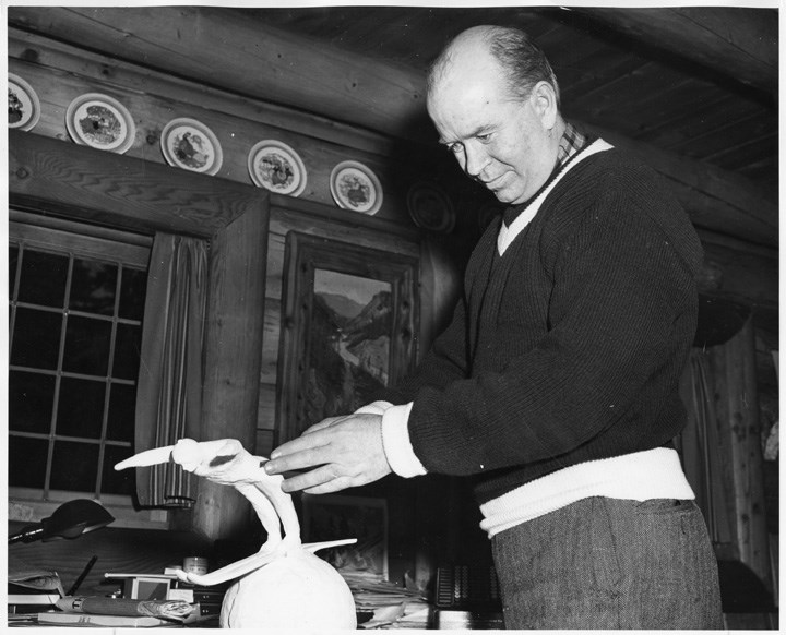
[Peter Whyte sculpting]
https://archives.whyte.org/en/permalink/descriptions50265
- Part Of
- Peter and Catharine Whyte fonds
- Scope & Content
- Image of Peter Whyte sculpting "Ski Jumper" trophy in 1949
- Date Range
- 1949
- Reference Code
- V683 / III / A / 1 / PA - 119
- Description Level
- 6 / Item
- GMD
- Photograph
1 image
- Part Of
- Peter and Catharine Whyte fonds
- Description Level
- 6 / Item
- Fonds Number
- M36 / V683 / S37
- Series
- V683 / III / A / 1 : Peter and Catharine Whyte: Personal Photographs
- Sous-Fonds
- V683
- Accession Number
- .
- Reference Code
- V683 / III / A / 1 / PA - 119
- GMD
- Photograph
- Date Range
- 1949
- Physical Description
- Photographs: 1 prints; b&w.
- Scope & Content
- Image of Peter Whyte sculpting "Ski Jumper" trophy in 1949
- Name Access
- Whyte, Peter
- Geographic Access
- Banff
- Language
- English
- Title Source
- Title based on item
- Processing Status
- Processed
Images
This material is presented as originally created; it may contain outdated cultural descriptions and
potentially offensive content.
Read more.
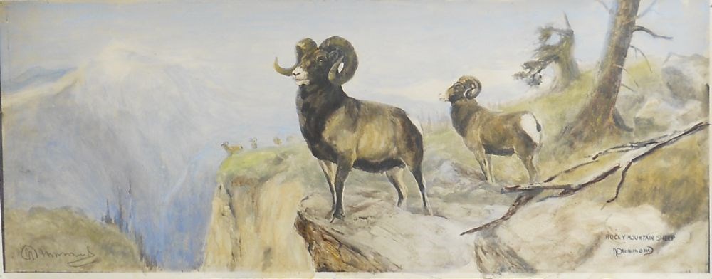
Rocky Mountain Sheep
https://archives.whyte.org/en/permalink/artifactdmn.04.02
- Date
- 1949
- Medium
- print on paper
- Catalogue Number
- DmN.04.02
- Description
- A coloured print of two sheep on a rock ledge in the foreground and four in the background (two clear sheep, two muted) on a grassy ledge. Left hand side a canyon, snow-covered mountain beyond and background sheep. Mid-to right the two larger sheep, rocks, tree branch, tree trunk and stunted tree i…
1 image
- Title
- Rocky Mountain Sheep
- Date
- 1949
- Medium
- print on paper
- Dimensions
- 13.7 x 35.2 cm
- Description
- A coloured print of two sheep on a rock ledge in the foreground and four in the background (two clear sheep, two muted) on a grassy ledge. Left hand side a canyon, snow-covered mountain beyond and background sheep. Mid-to right the two larger sheep, rocks, tree branch, tree trunk and stunted tree in the background. Blue and white hazy sky across the top.
- Subject
- landscape
- mountains
- Rocky Mountain sheep
- Credit
- Gift of Helen Shandruk, Banff, 1995
- Catalogue Number
- DmN.04.02
Images
This material is presented as originally created; it may contain outdated cultural descriptions and
potentially offensive content.
Read more.
Topographical Map
https://archives.whyte.org/en/permalink/catalogue24619
- Medium
- Library - Maps and blueprints (unannotated; published)
- Map
- Published Date
- 1948
- Publisher
- Dept. of Mines and Resources
- Call Number
- C3-2.4
- Publisher
- Dept. of Mines and Resources
- Published Date
- 1948
- Physical Description
- Colour
- Scale
- Scale: 1:63,360
- Relief: Contour interval 100'
- Subjects
- Lake Louise
- Accession Number
- 1105
- Call Number
- C3-2.4
- Collection
- Archives Library
This material is presented as originally created; it may contain outdated cultural descriptions and
potentially offensive content.
Read more.
Province of Alberta
https://archives.whyte.org/en/permalink/catalogue24409
- Medium
- Library - Maps and blueprints (unannotated; published)
- Map
- Published Date
- 1947
- Publisher
- Alberta Dept. of Lands and Mines
- Call Number
- C9-1.19
- Publisher
- Alberta Dept. of Lands and Mines
- Published Date
- 1947
- Physical Description
- 1 map
- Scale
- Scale: 1 inch = 16 miles
- Subjects
- Alberta
- Notes
- In oversize cabinet (rolled up)
- Accession Number
- 6406
- Call Number
- C9-1.19
- Collection
- Archives Library
This material is presented as originally created; it may contain outdated cultural descriptions and
potentially offensive content.
Read more.
Topographic Map
https://archives.whyte.org/en/permalink/catalogue24621
- Medium
- Library - Maps and blueprints (unannotated; published)
- Map
- Published Date
- 1947
- Publisher
- Dept. of Mines and Resources
- Call Number
- C3-3.1
- Publisher
- Dept. of Mines and Resources
- Published Date
- 1947
- Physical Description
- Colour
- Scale
- Scale: 1": 1 mile
- Relief: Contour interval 100'
- Subjects
- Sunwapta
- Accession Number
- 442
- Call Number
- C3-3.1
- Collection
- Archives Library
This material is presented as originally created; it may contain outdated cultural descriptions and
potentially offensive content.
Read more.
Jasper Park South Sheet
https://archives.whyte.org/en/permalink/catalogue23180
- Medium
- Library - Maps and blueprints (unannotated; published)
- Map
- Published Date
- 1947
- Publisher
- Dept. of Mines and Resources
- Call Number
- C2-2.7
- Publisher
- Dept. of Mines and Resources
- Published Date
- 1947
- Scale
- Scale: 3 miles to 1 inch
- Notes
- Relief: Contour Interval 200'
- Accession Number
- 400, 718
- Call Number
- C2-2.7
- Collection
- Archives Library
This material is presented as originally created; it may contain outdated cultural descriptions and
potentially offensive content.
Read more.
[Jasper Park]
https://archives.whyte.org/en/permalink/catalogue23181
- Medium
- Library - Maps and blueprints (unannotated; published)
- Map
- Published Date
- 1947
- Publisher
- Dept. of Mines and Technical Surveys
- Call Number
- C2-2.8
- Publisher
- Dept. of Mines and Technical Surveys
- Published Date
- 1947
- Physical Description
- 1 map : col
- Scale
- Scale: 1 inch : 3 miles
- Relief: Contour Interval 200 ft
- Subjects
- Jasper National Park
- Notes
- Dup. in Research Room/2 Dup. in Map Room
- Accession Number
- 3000
- 673
- 1153 M. 171
- 1096
- 3349
- Call Number
- C2-2.8
- Collection
- Archives Library
This material is presented as originally created; it may contain outdated cultural descriptions and
potentially offensive content.
Read more.
[Jasper Park (South Sheet)]
https://archives.whyte.org/en/permalink/catalogue23182
- Medium
- Library - Maps and blueprints (unannotated; published)
- Map
- Published Date
- 1947 (interim corrections 1974)
- Publisher
- Department of Mines and Technical Surveys
- Call Number
- C2-2.8 (a)
- Publisher
- Department of Mines and Technical Surveys
- Published Date
- 1947 (interim corrections 1974)
- Physical Description
- 1 map : col
- Scale
- Scale: I inch: 3 miles
- Relief: Counter interval 200 ft.
- Subjects
- Jasper National Park
- Accession Number
- 7000
- Call Number
- C2-2.8 (a)
- Collection
- Archives Library
This material is presented as originally created; it may contain outdated cultural descriptions and
potentially offensive content.
Read more.
[Deep Valley Creek South, Alberta]
https://archives.whyte.org/en/permalink/catalogue23579
- Medium
- Library - Maps and blueprints (unannotated; published)
- Map
- Published Date
- 1947
- Publisher
- Dept. of Mines & Technical Survey
- Call Number
- NTS
- 82K/4E
- Publisher
- Dept. of Mines & Technical Survey
- Published Date
- 1947
- Scale
- Scale: 1:50,000
- Subjects
- Deep Valley Creek
- Alberta
- Notes
- National Topographic System
- Accession Number
- 12000
- Call Number
- NTS
- 82K/4E
- Collection
- Archives Library
This material is presented as originally created; it may contain outdated cultural descriptions and
potentially offensive content.
Read more.
[Deep Valley Creek South, Alberta]
https://archives.whyte.org/en/permalink/catalogue23580
- Medium
- Library - Maps and blueprints (unannotated; published)
- Map
- Published Date
- 1947
- Publisher
- Dept. of Mines & Technical Survey
- Call Number
- NTS
- 83K/4W
- Publisher
- Dept. of Mines & Technical Survey
- Published Date
- 1947
- Scale
- Scale: 1:50,000
- Subjects
- Deep Valley Creek
- Alberta
- Notes
- National Topographic System
- Accession Number
- 12000
- Call Number
- NTS
- 83K/4W
- Collection
- Archives Library
This material is presented as originally created; it may contain outdated cultural descriptions and
potentially offensive content.
Read more.
Wapta Lodge brochure photograph
https://archives.whyte.org/en/permalink/descriptions56910
- Part Of
- Nicholas Morant fonds
- Scope & Content
- File consists of one photograph depicting Jean Thompson, Ann (Lawrence) Tomlinson, and four unidentified individuals posing inside Wapta Lodge. Photograph was produced by Nicholas Morant for use in a promotional brochure for Wapta Lodge in 1947.
- Date Range
- 1947
- Reference Code
- V500 / II / C / 5 / PA - 689
- Description Level
- 5 / File
- GMD
- Photograph
- Part Of
- Nicholas Morant fonds
- Description Level
- 5 / File
- Fonds Number
- M300
- S20
- V500
- Series
- V500 / II : Professional records
- Sous-Fonds
- V500
- Sub-Series
- V500 / II / C / 5 : Professional Photography
- Accession Number
- 8148
- Reference Code
- V500 / II / C / 5 / PA - 689
- GMD
- Photograph
- Responsibility
- Produced by Nicholas Morant
- Date Range
- 1947
- Physical Description
- 1 photograph : b&w print ; 25 x 20.5 cm
- Scope & Content
- File consists of one photograph depicting Jean Thompson, Ann (Lawrence) Tomlinson, and four unidentified individuals posing inside Wapta Lodge. Photograph was produced by Nicholas Morant for use in a promotional brochure for Wapta Lodge in 1947.
- Notes
- Annotated on front of photograph below image in blue ink: "WAPTA 1947 Jean + Ann are at the piano"
- Annotated [by Jean Thompson] in blue and black ink on back of photograph: "This photo was used in Wapta Brochures. I am at the piano + Ann Lawrence (now Tomlinson) is standing by piano."
- Photograph includes Nicholas Morant copyright stamp on back
- Name Access
- Thompson, Jean
- Lawrence, Ann
- Subject Access
- Promo
- Advertising
- Wapta Lodge
- Tourism
- Geographic Access
- Canada
- British Columbia
- Language
- English
- Category
- Tourism
- Title Source
- Title based on contents of file
- Processing Status
- Processed
This material is presented as originally created; it may contain outdated cultural descriptions and
potentially offensive content.
Read more.
Beta Sigma Phi social function
https://archives.whyte.org/en/permalink/descriptions55685
- Part Of
- Maryalice Harvey Stewart fonds
- Scope & Content
- File consists of one photograph depicting Maryalice Harvey Stewart and four friends at a Beta Sigma Phi social function in Tulsa, Oklahoma, 1947.
- Date Range
- 1947
- Reference Code
- V605 / II / PA - 11
- Description Level
- 5 / File
- GMD
- Photograph
- Part Of
- Maryalice Harvey Stewart fonds
- Description Level
- 5 / File
- Fonds Number
- M9
- S13
- V605
- Series
- V605 / II : Personal records
- Sous-Fonds
- V605
- Accession Number
- 7412
- Reference Code
- V605 / II / PA - 11
- GMD
- Photograph
- Date Range
- 1947
- Physical Description
- 1 photograph : b&w print ; 25 x 20 cm
- Scope & Content
- File consists of one photograph depicting Maryalice Harvey Stewart and four friends at a Beta Sigma Phi social function in Tulsa, Oklahoma, 1947.
- Material Details
- Annotated on back: "#1 Thelma Vancleave Thelma Fancher Beta Sigma Phi Social Function Tulsa, OK. c 1947 Maryalice Stewart, Centre"
- Subject Access
- Family and personal life
- Religions
- Organizations
- Events
- Geographic Access
- United States of America
- Oklahoma
- Tulsa
- Language
- English
- Category
- Family and personal life
- Religions
- Title Source
- Title retrieved from back of photograph in file
- Processing Status
- Processed
This material is presented as originally created; it may contain outdated cultural descriptions and
potentially offensive content.
Read more.
[United States]
https://archives.whyte.org/en/permalink/catalogue24812
- Medium
- Library - Maps and blueprints (unannotated; published)
- Map
- Published Date
- 1946
- Publisher
- National Geographic Society
- Call Number
- C13-1.1(d)
- Publisher
- National Geographic Society
- Published Date
- 1946
- Scale
- Scale: 78.91 miles to 1 inch
- Relief: Bench marks
- Subjects
- United States
- Accession Number
- 495
- Call Number
- C13-1.1(d)
- Collection
- Archives Library
This material is presented as originally created; it may contain outdated cultural descriptions and
potentially offensive content.
Read more.
[RECONNAISSANCE PLAN: BANFF_MT. ASSINIBOINE PARK ROUTE 4 via Healy Creek, Sunshine Lodge, Citadel Pass]
https://archives.whyte.org/en/permalink/catalogue24909
- Medium
- Library - Maps and blueprints (unannotated; published)
- Map
- Published Date
- 1946 (transfered to manuscript Oct. 1994)
- Call Number
- C2-10.1 (d)
- Published Date
- 1946 (transfered to manuscript Oct. 1994)
- Scale
- 1) Scale: 4 ": 1 mile
- Relief - Counter interval 50 ft.
- 2) Scale: 1 ": 200 ft.
- Relief - Counter interval: 5 ft.
- Subjects
- Mount Assiniboine Provincial Park
- Notes
- 2) = Plan of Healy Creek_Mt. Assiniboine Proposed Location Class "C" Highway Survey 1946/Section 1_Banff to Healy Creek
- 5) Sunshine to Quartz Hill
- 6) 3 sections
- Accession Number
- 2158
- Call Number
- C2-10.1 (d)
- Collection
- Archives Library
This material is presented as originally created; it may contain outdated cultural descriptions and
potentially offensive content.
Read more.
Map showing Coalfields, Potential Coal Areas and Coal occurences of Canada
https://archives.whyte.org/en/permalink/catalogue21472
- Medium
- Library - Book (including soft-cover and pamphlets)
- Map
- Published Date
- 1946
- Publisher
- Dept. of Mines and Resources
- Call Number
- C7-5.7
- Publisher
- Dept. of Mines and Resources
- Published Date
- 1946
- Subjects
- Canada - Coal Areas
- Accession Number
- 3071
- Call Number
- C7-5.7
- Collection
- Archives Library
This material is presented as originally created; it may contain outdated cultural descriptions and
potentially offensive content.
Read more.
Glacier Park, B.C.
https://archives.whyte.org/en/permalink/catalogue23225
- Medium
- Library - Maps and blueprints (unannotated; published)
- Map
- Published Date
- 1946
- Publisher
- Ottawa, Tophographical Survey of Canada
- Call Number
- C2-7.5a
- Publisher
- Ottawa, Tophographical Survey of Canada
- Published Date
- 1946
- Physical Description
- 1 map : col
- Scale
- Scale: 1:126,720
- Subjects
- Glacier National Park
- Accession Number
- 3349
- Call Number
- C2-7.5a
- Collection
- Archives Library
This material is presented as originally created; it may contain outdated cultural descriptions and
potentially offensive content.
Read more.
[Blairmore 82G/9 West, Alberta]
https://archives.whyte.org/en/permalink/catalogue23501
- Medium
- Library - Maps and blueprints (unannotated; published)
- Map
- Published Date
- 1946
- Publisher
- Dept. of Mines and Techinical Surveys
- Call Number
- NTS
- 82G/9W
- Publisher
- Dept. of Mines and Techinical Surveys
- Published Date
- 1946
- Physical Description
- 1 map : col
- Scale
- Scale: 1:50,000
- Relief: Contour interval 100'
- Subjects
- Blairmore
- Western Alberta
- Notes
- National Topographic System
- Call Number
- NTS
- 82G/9W
- Collection
- Archives Library
This material is presented as originally created; it may contain outdated cultural descriptions and
potentially offensive content.
Read more.
[Moberly Creek - Alberta]
https://archives.whyte.org/en/permalink/catalogue23741
- Medium
- Library - Maps and blueprints (unannotated; published)
- Map
- Published Date
- 1946
- Publisher
- Dept. of Mines & Technical Surveys
- Call Number
- NTS
- 83E/9
- Publisher
- Dept. of Mines & Technical Surveys
- Published Date
- 1946
- Scale
- 1:50,000
- Subjects
- Moberly Creek - Alberta
- Notes
- National Topographic System
- Provisional Map
- Accession Number
- 12000
- Call Number
- NTS
- 83E/9
- Collection
- Archives Library
This material is presented as originally created; it may contain outdated cultural descriptions and
potentially offensive content.
Read more.