Narrow Results By
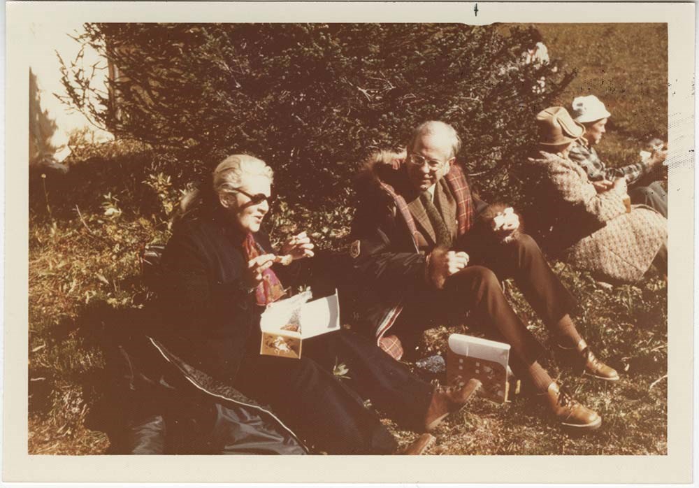
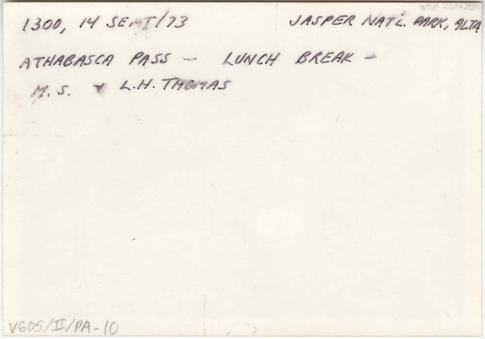
Athabasca Pass trip
https://archives.whyte.org/en/permalink/descriptions55684
- Part Of
- Maryalice Harvey Stewart fonds
- Scope & Content
- File consists of 10 photographs depicting Maryalice Harvey Stewart and friends during a trip to Athabasca Pass in Jasper National Park to celebrate the unveiling of a historic site plaque.
- Date Range
- 1973
- Reference Code
- V605 / II / PA - 1 to 10
- Description Level
- 5 / File
- GMD
- Photograph
2 images
- Part Of
- Maryalice Harvey Stewart fonds
- Description Level
- 5 / File
- Fonds Number
- M9
- S13
- V605
- Series
- V605 / II: Personal records
- Sous-Fonds
- V605
- Accession Number
- 2014.8310
- Reference Code
- V605 / II / PA - 1 to 10
- GMD
- Photograph
- Date Range
- 1973
- Physical Description
- 11 photographs : col. prints ; 12.5 x 9 cm and 9 x 9 cm
- Scope & Content
- File consists of 10 photographs depicting Maryalice Harvey Stewart and friends during a trip to Athabasca Pass in Jasper National Park to celebrate the unveiling of a historic site plaque.
- Name Access
- Stewart, Maryalice Harvey
- Subject Access
- Family and personal life
- Travel
- History
- National parks and reserves
- Events
- Geographic Access
- Canada
- Alberta
- Jasper National Park
- Athabasca
- Language
- English
- Conservation
- Items stored in mylar
- Title Source
- Title based on contents of file
- Processing Status
- Processed
Images
This material is presented as originally created; it may contain outdated cultural descriptions and
potentially offensive content.
Read more.
Travel guides and maps
https://archives.whyte.org/en/permalink/descriptions56361
- Part Of
- Ben Gadd fonds
- Scope & Content
- Sub-series consists of travel brochures and maps which were collected and used by Ben Gadd. Sub-series contains five sub-sub series: M590 / I / A / i : Travel guides and pocket maps M590 / I / A / ii : Topographical maps M590 / I / A / iii : Geological maps M590 / I / A / iv : Highway maps M590 / …
- Date Range
- [ca.1920-2010]
- Reference Code
- M590 / I / A
- Description Level
- 4 / Sub-series
- GMD
- Map
- Textual record
- Part Of
- Ben Gadd fonds
- Description Level
- 4 / Sub-series
- Fonds Number
- M590
- V810
- S61
- Series
- M590 / I : Personal records
- Sous-Fonds
- M590
- Sub-Series
- M590 / I / A : Travel guides and maps
- Accession Number
- 2021.20
- Reference Code
- M590 / I / A
- GMD
- Map
- Textual record
- Date Range
- [ca.1920-2010]
- Physical Description
- ca. 274 maps -- ca. 61 travel guides, brochures
- Scope & Content
- Sub-series consists of travel brochures and maps which were collected and used by Ben Gadd. Sub-series contains five sub-sub series: M590 / I / A / i : Travel guides and pocket maps M590 / I / A / ii : Topographical maps M590 / I / A / iii : Geological maps M590 / I / A / iv : Highway maps M590 / I / A / v : Index maps, other
- Notes
- Some materials in sub-series are annotated with notes by Ben Gadd
- Name Access
- Gadd, Ben
- Subject Access
- Geography
- Geology
- Environment
- Map
- Tourism
- Tourist information
- Travel
- Trails
- Roads
- Transportation
- Natural history
- National parks and reserves
- Provincial parks and reserves
- Government
- Sports
- Recreation
- Hiking
- Geographic Access
- Canada
- Alberta
- British Columbia
- Banff National Park
- Jasper National Park
- Kootenay National Park
- Yoho National Park
- Waterton Lakes National Park
- Columbia Icefields
- United States of America
- Colorado
- Montana
- Yellowstone National Park
- Access Restrictions
- Restrictions may apply - some materials are fragile
- Reproduction Restrictions
- Restrictions may apply
- Language
- English
- Conservation
- Some fragile/torn materials stored in mylar
- Category
- Environment
- Exploration, discovery and travel
- Government
- Sports, recreation and leisure
- Transportation
- Tourism
- Title Source
- Title based on contents of sub-series
- Processing Status
- Processed
This material is presented as originally created; it may contain outdated cultural descriptions and
potentially offensive content.
Read more.
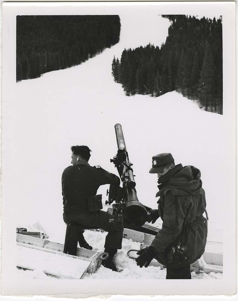
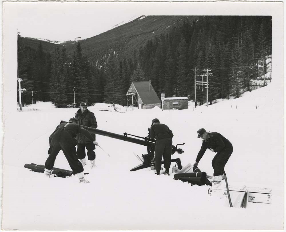
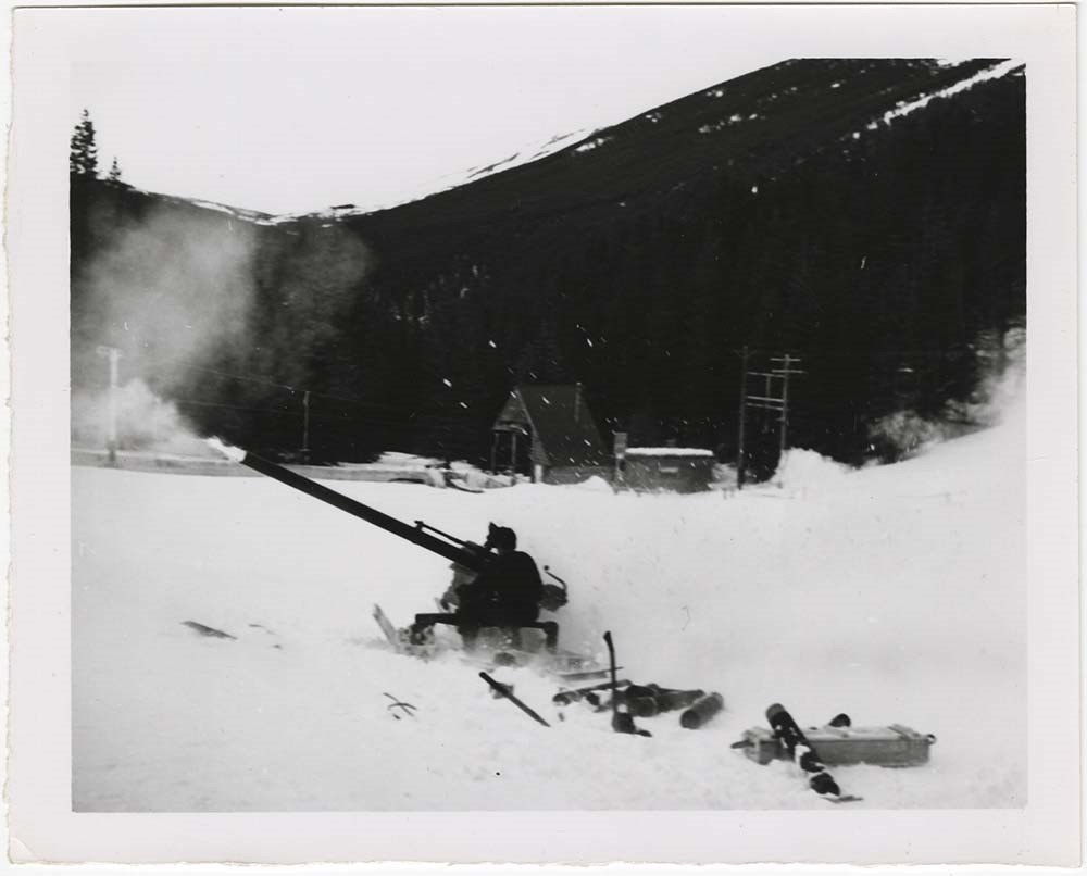
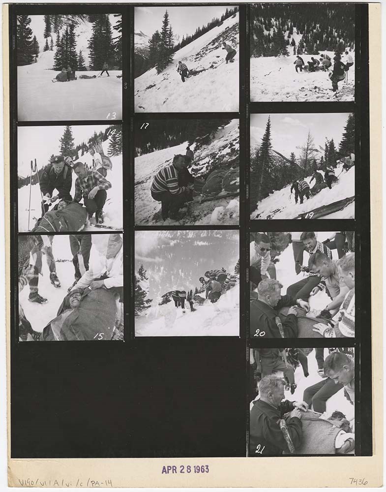
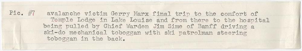
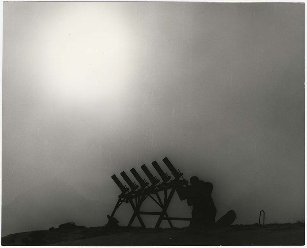
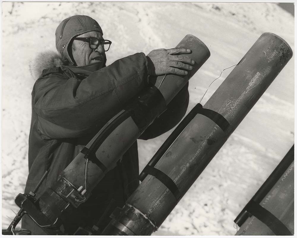
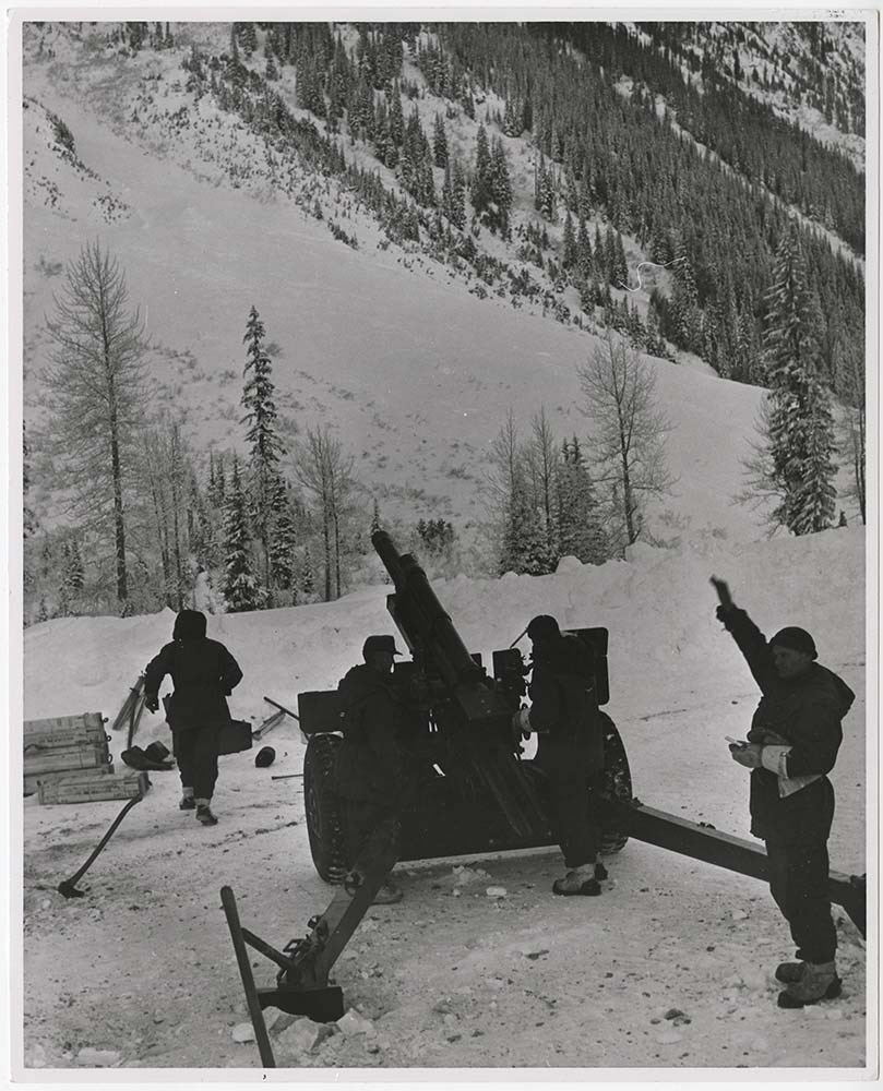
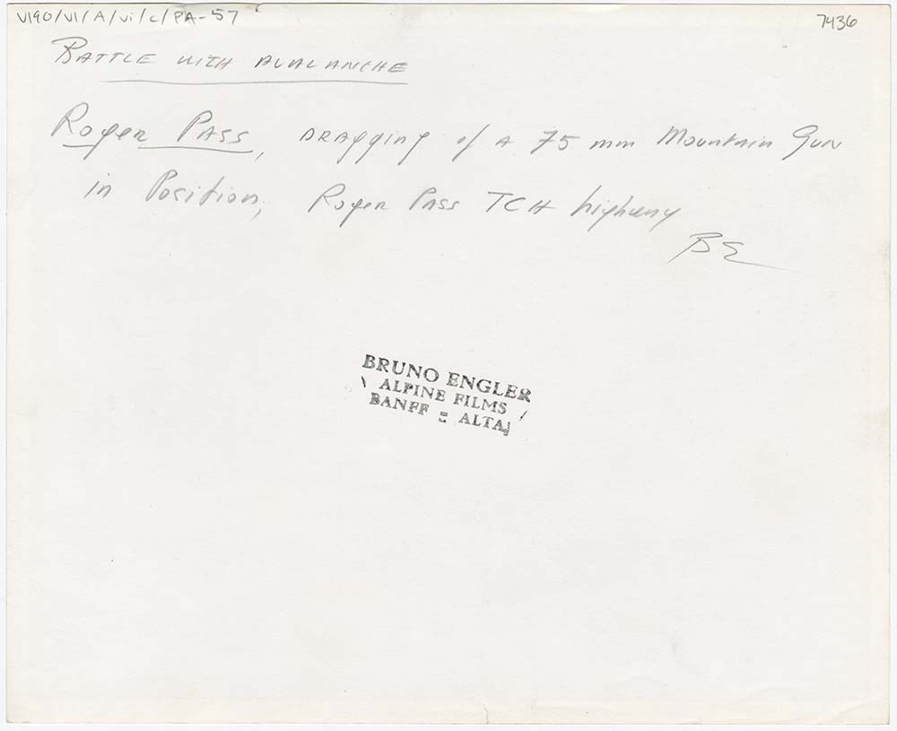
Avalanche Control [1/2]
https://archives.whyte.org/en/permalink/descriptions56748
- Part Of
- Bruno Engler fonds
- Scope & Content
- File pertains to 62 b&w prints of various avalanche control operations around Banff National Park, usually along highways and around ski hills. Also includes photographs from a rescue operation and accompanying news clippings pertaining to that rescue.
- Date Range
- 1956-1979
- Reference Code
- V190 / VI / A / vi / c / PA - 01 to PA - 62
- Description Level
- 5 / File
- GMD
- Photograph
17 images
- Part Of
- Bruno Engler fonds
- Description Level
- 5 / File
- Fonds Number
- M323 / S40 / V190
- Series
- VI : Retained file, A : Alphabetical order
- Sous-Fonds
- V190
- Sub-Series
- vi : Avalanches, c : Control
- Accession Number
- 7436
- Reference Code
- V190 / VI / A / vi / c / PA - 01 to PA - 62
- GMD
- Photograph
- Date Range
- 1956-1979
- Physical Description
- 62 photographs : b&w ; 20.3 x 25.4 cm or smaller
- History / Biographical
- See fonds level description
- Scope & Content
- File pertains to 62 b&w prints of various avalanche control operations around Banff National Park, usually along highways and around ski hills. Also includes photographs from a rescue operation and accompanying news clippings pertaining to that rescue.
- Notes
- Photographs included in this entry were originally housed in a photo paper box identified by Bruno Engler prior to accessioning.
- Subject Access
- Aerial photography
- Avalanches
- Banff-Jasper Highway
- Lake Louise Ski Area
- Mountains
- Rescue
- Rogers Pass
- Ski areas
- Sunshine Ski Resort
- Winter
- Geographic Access
- Banff National Park
- Jasper National Park
- Alberta
- Language
- English
- Conservation
- PA - 25 has two overlapping pieces of masking tape on the back, holding the two torn pieces of the print together
- Creator
- Engler, Bruno
- Title Source
- Original title kept
- Processing Status
- Processed
Images


This material is presented as originally created; it may contain outdated cultural descriptions and
potentially offensive content.
Read more.
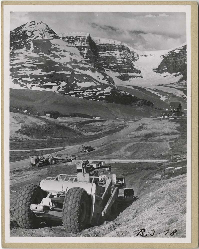
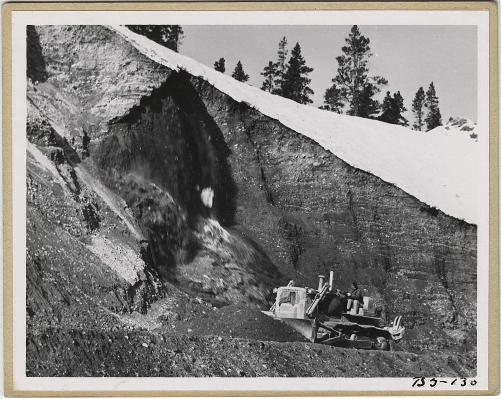
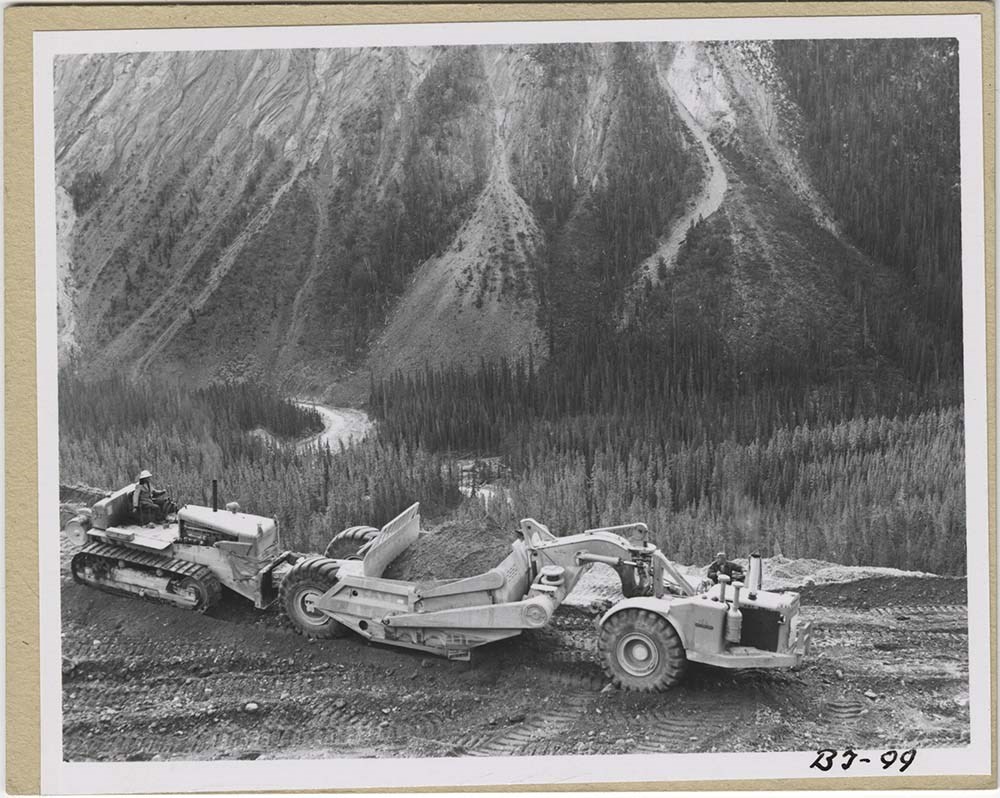
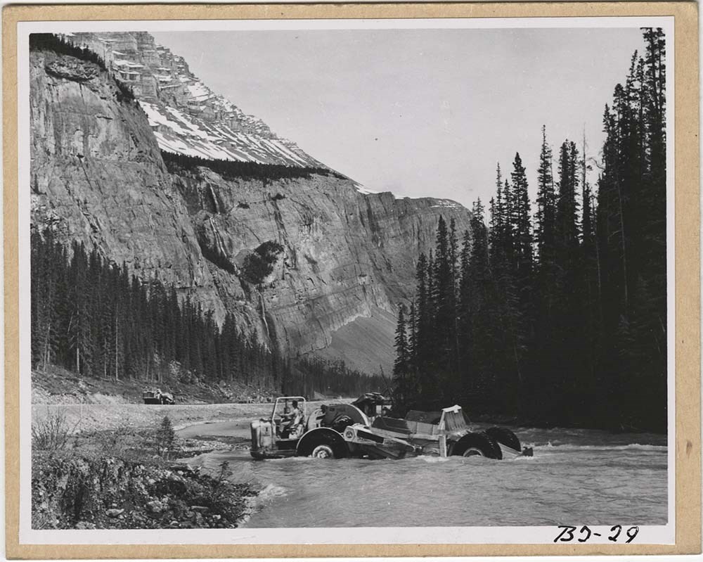
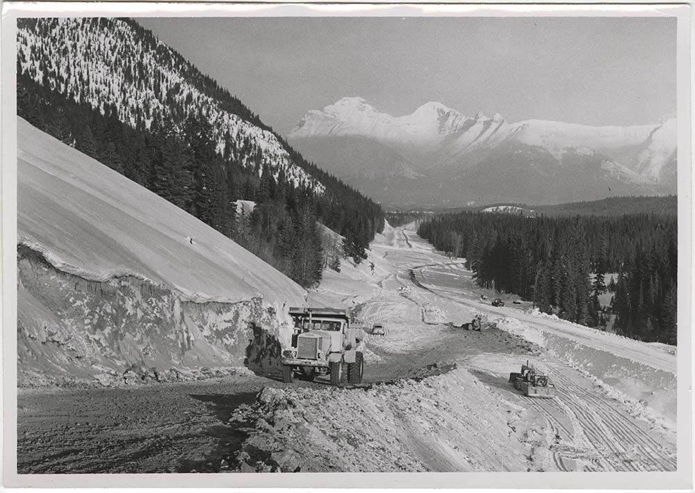
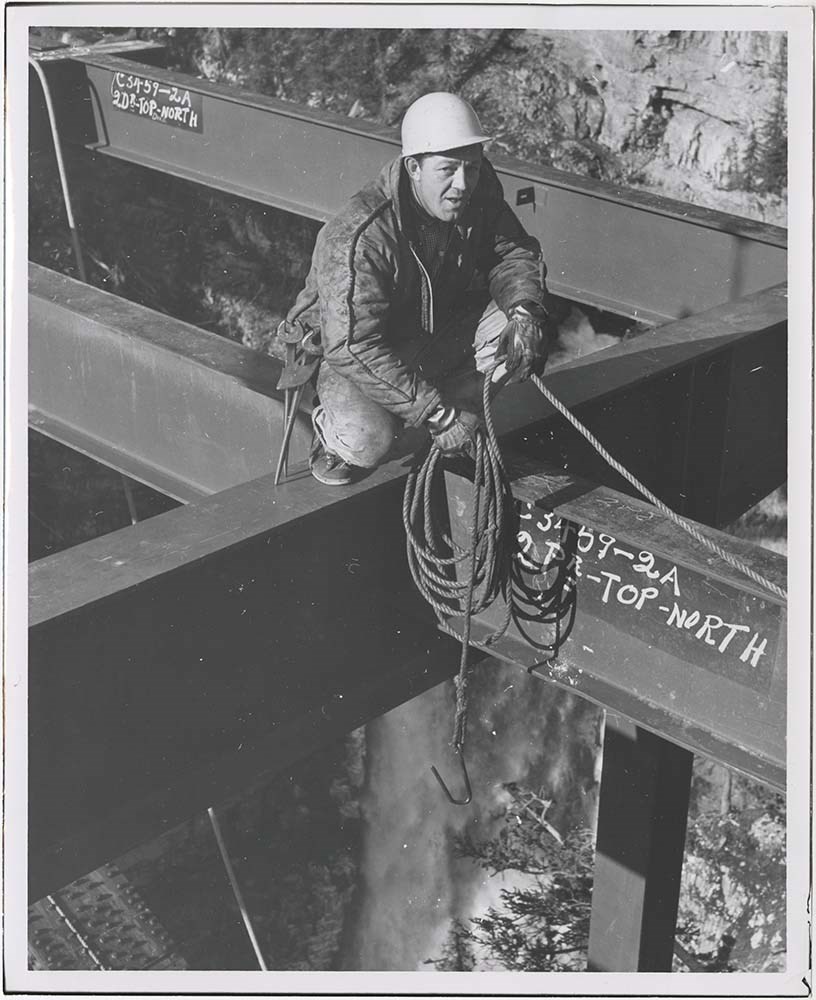
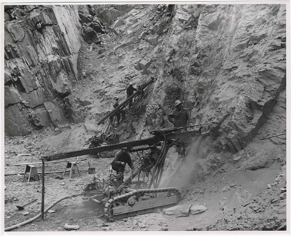
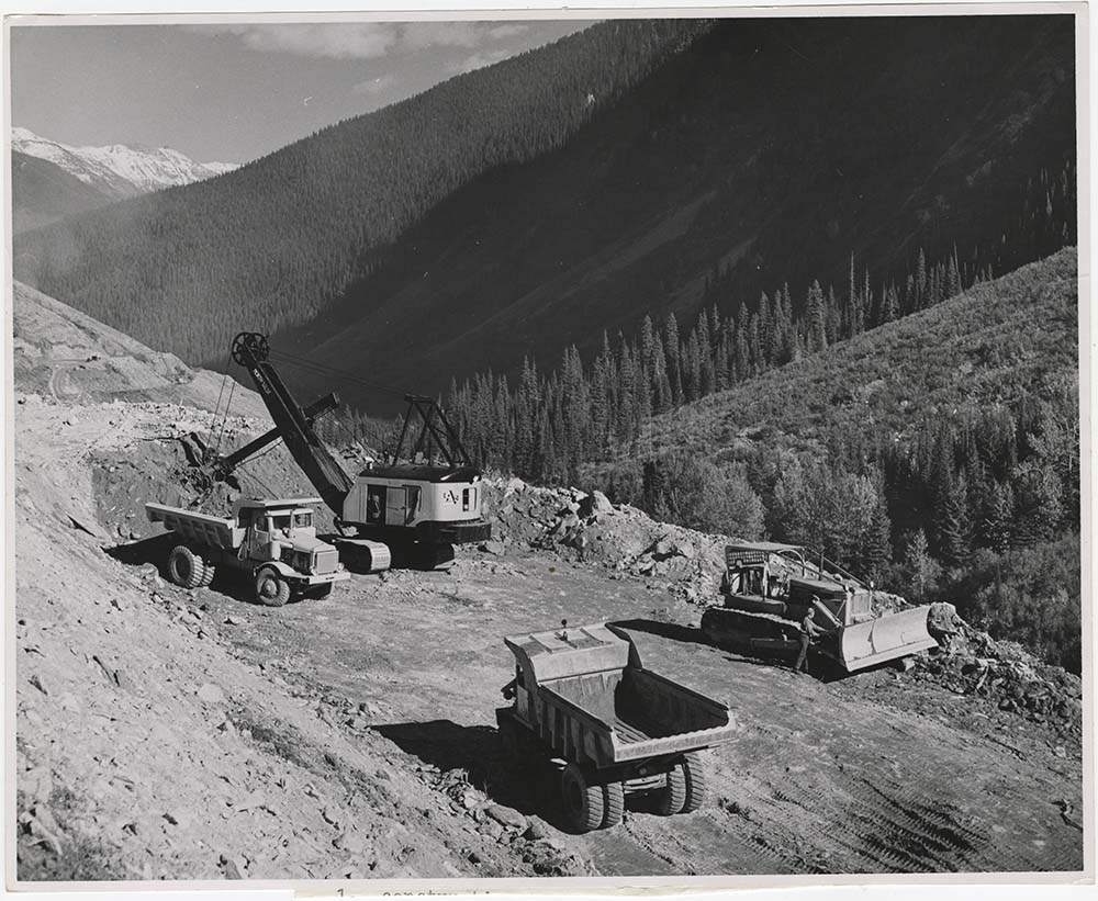
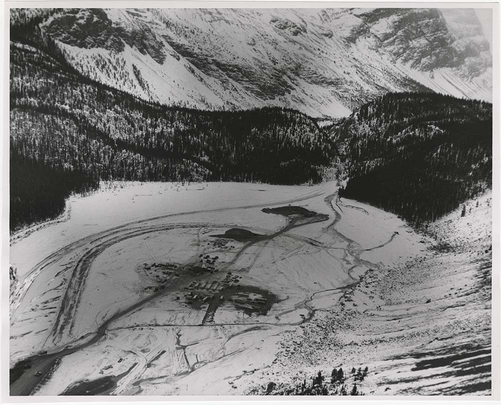
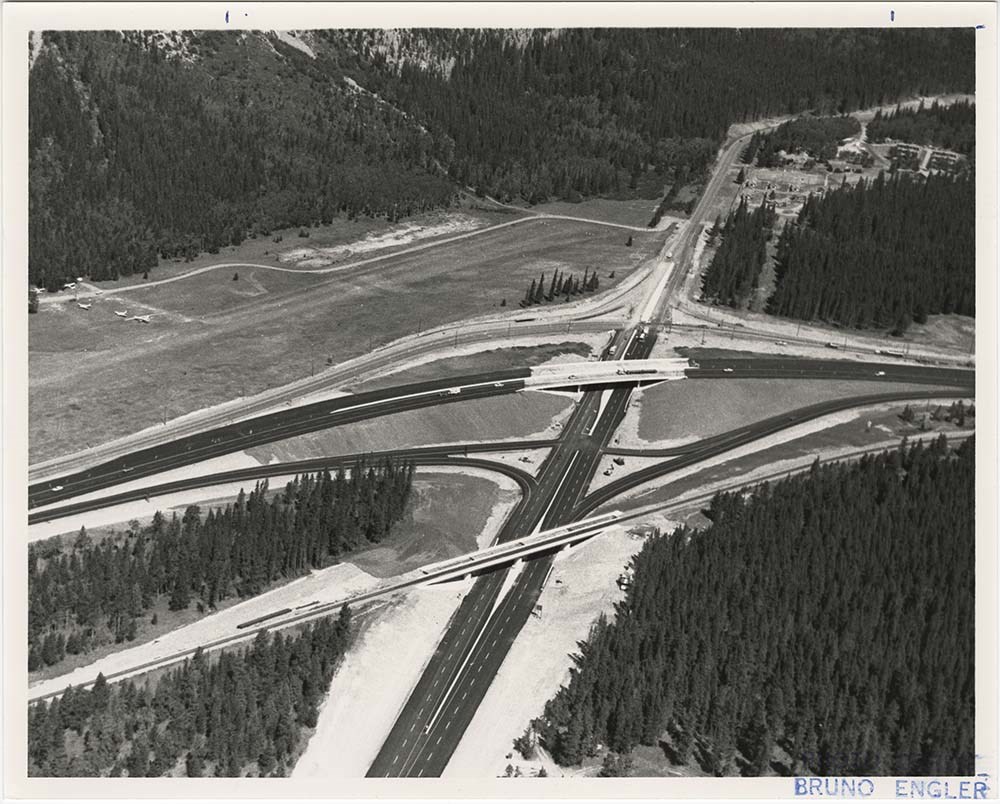
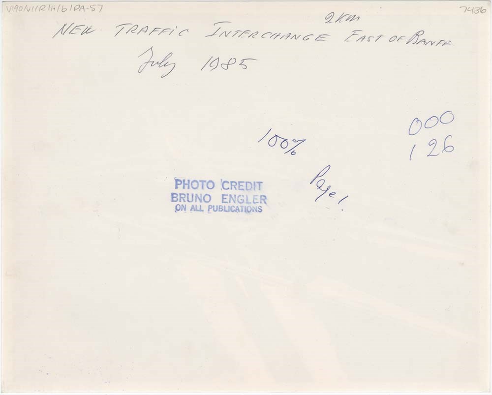
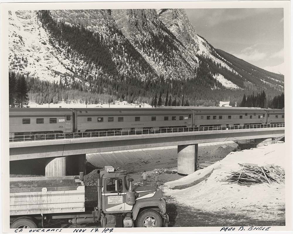
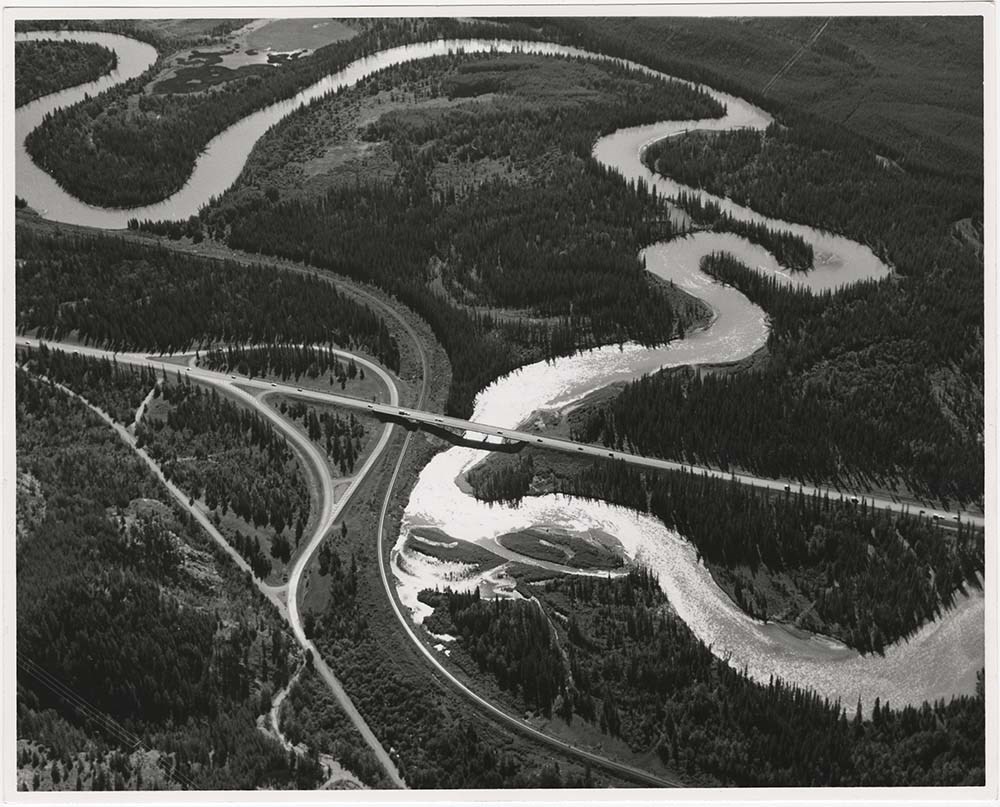
Road Constructions
https://archives.whyte.org/en/permalink/descriptions57427
- Part Of
- Bruno Engler fonds
- Scope & Content
- File pertains to 62 b&w prints of construction of the Banff-Jasper Highway [the Icefield Parkway], as well as a few shots of the Trans-Canada Highway construction just west of the town of Banff.
- Date Range
- 1957-1962
- Reference Code
- V190 / VI / R / ii / b / PA - 01 to PA - 62
- Description Level
- 5 / File
- GMD
- Photograph
14 images
- Part Of
- Bruno Engler fonds
- Description Level
- 5 / File
- Fonds Number
- M323 / S40 / V190
- Series
- VI : Retained file, R : Alphabetical order
- Sous-Fonds
- V190
- Sub-Series
- ii : Roads, b : Construction
- Accession Number
- 7436
- Reference Code
- V190 / VI / R / ii / b / PA - 01 to PA - 62
- GMD
- Photograph
- Date Range
- 1957-1962
- Physical Description
- 62 photographs : b&w ; 25.2 x 20.2 cm or smaller
- History / Biographical
- See fonds level description
- Scope & Content
- File pertains to 62 b&w prints of construction of the Banff-Jasper Highway [the Icefield Parkway], as well as a few shots of the Trans-Canada Highway construction just west of the town of Banff.
- Subject Access
- Athabasca Glacier
- Banff-Jasper Highway
- Bridges
- Construction
- Glaciers
- Mountains
- Trans-Canada Highway
- Roads
- Geographic Access
- Banff
- Banff National Park
- Jasper National Park
- Alberta
- Language
- English
- Creator
- Engler, Bruno
- Title Source
- Original title kept
- Processing Status
- Processed
Images


This material is presented as originally created; it may contain outdated cultural descriptions and
potentially offensive content.
Read more.
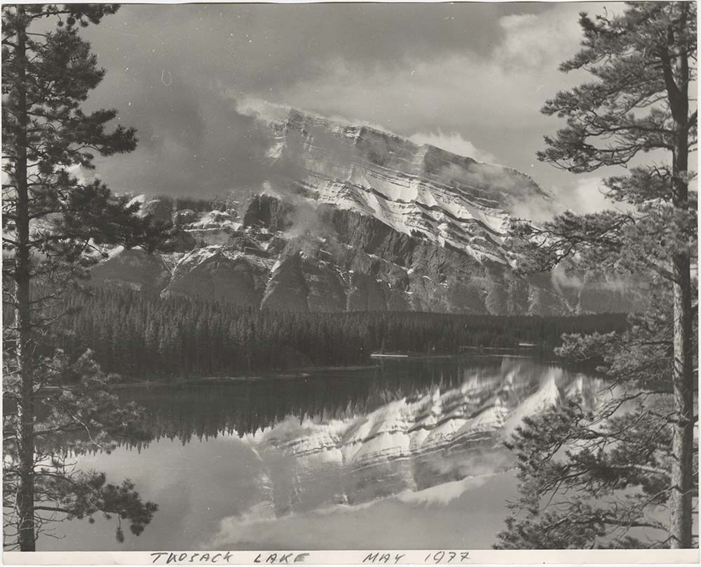
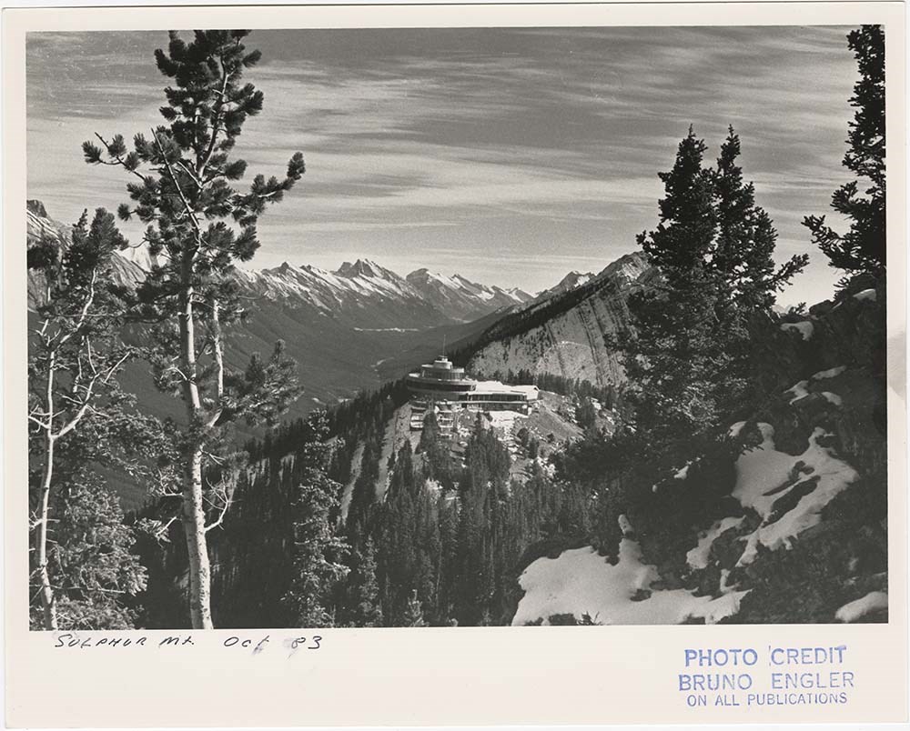
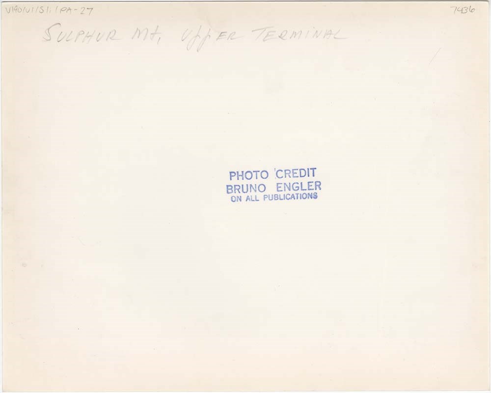
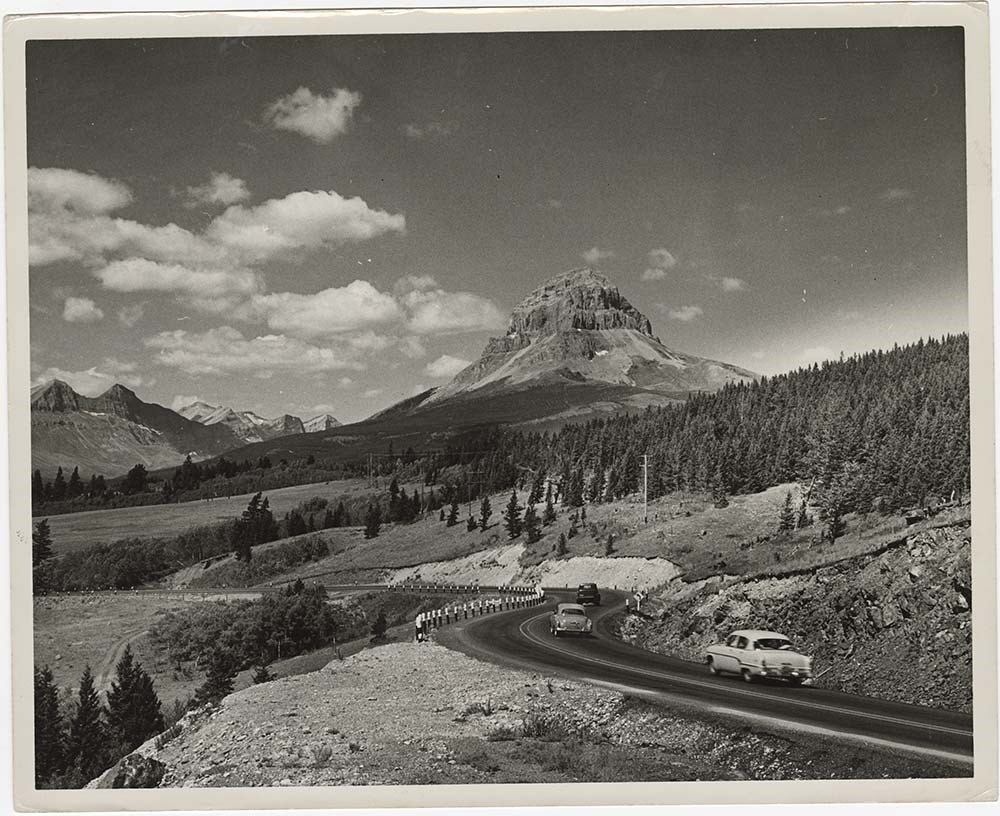
- Part Of
- Bruno Engler fonds
- Scope & Content
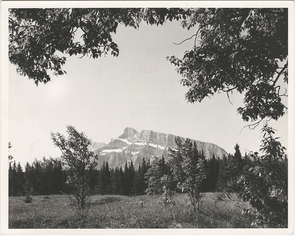
- File pertains to 40 b&w prints of various scenic views from throught the Canadian Rockies. Includes several mountains [including Rundle, Cascade, Mount Lougheed, Ha Ling, Sulphur ], lakes [including Two Jack, Vermillion, Bow, Peyto, and Waterton], and various other views like highways, rivers, hood…
- Date Range
- [ca. 1950-1988]
- Reference Code
- V190 / VI / S / i / PA - 01 to PA - 40
- Description Level
- 5 / File
- GMD
- Photograph
10 images
- Part Of
- Bruno Engler fonds
- Description Level
- 5 / File
- Fonds Number
- M323 / S40 / V190
- Series
- VI : Retained file, S : Alphabetical order
- Sous-Fonds
- V190
- Sub-Series
- i : Scenic Park
- Accession Number
- 7436
- Reference Code
- V190 / VI / S / i / PA - 01 to PA - 40
- GMD
- Photograph
- Date Range
- [ca. 1950-1988]
- Physical Description
- 40 photographs : b&w ; 25.2 x 20.2 cm or smaller
- History / Biographical
- See fonds level description
- Scope & Content
- File pertains to 40 b&w prints of various scenic views from throught the Canadian Rockies. Includes several mountains [including Rundle, Cascade, Mount Lougheed, Ha Ling, Sulphur ], lakes [including Two Jack, Vermillion, Bow, Peyto, and Waterton], and various other views like highways, rivers, hoodoos, tunnels, and valleys.
- Subject Access
- Automobiles
- Banff townsite
- Banff-Jasper Highway
- Bow River
- Bow Valley
- Cascade Mountain
- Cascades of Time Garden
- Fishing
- Glaciers
- Hoodoos
- Icefield Parkway
- Mountains
- North Saskatchewan River
- Rivers
- Roads
- Rundle Mountain
- scenic
- Sulphur Mountain
- Sulphur Mountain Gondola
- Trans-Canada Highway
- Two Jack Lake
- Geographic Access
- Banff
- Bow Lake
- Peyto Lake
- Banff National Park
- Jasper National Park
- Waterton
- Alberta
- Bugaboos
- British Columbia
- Language
- English
- Creator
- Engler, Bruno
- Title Source
- Original title kept
- Processing Status
- Processed
Images


This material is presented as originally created; it may contain outdated cultural descriptions and
potentially offensive content.
Read more.
Avalanche Control [2/2]
https://archives.whyte.org/en/permalink/descriptions57495
- Part Of
- Bruno Engler fonds
- Scope & Content
- File pertains to 6 boards with b&w negative contact sheets adhered to them depicting various areas prone to avalanches taken from a plane or helicopter. Includes views of ski areas and roads.
- Date Range
- 1956-1979
- Reference Code
- V190 / VI / A / vi / c / PA - 63 to PA - 68
- Description Level
- 5 / File
- GMD
- Photograph
- Part Of
- Bruno Engler fonds
- Description Level
- 5 / File
- Fonds Number
- M323 / S40 / V190
- Series
- VI : Retained file, A : Alphabetical order
- Sous-Fonds
- V190
- Sub-Series
- vi : Avalanches, c : Control
- Accession Number
- 7436
- Reference Code
- V190 / VI / A / vi / c / PA - 63 to PA - 68
- GMD
- Photograph
- Date Range
- 1956-1979
- Physical Description
- 6 photographs : b&w ; 23.4 x 34.2 cm or smaller
- History / Biographical
- See fonds level description
- Scope & Content
- File pertains to 6 boards with b&w negative contact sheets adhered to them depicting various areas prone to avalanches taken from a plane or helicopter. Includes views of ski areas and roads.
- Notes
- File came from box XVI, separate from alphabetised boxes
- Subject Access
- Aerial photography
- Avalanches
- Banff-Jasper Highway
- Lake Louise Ski Area
- Mountains
- Rescue
- Rogers Pass
- Ski areas
- Sunshine Ski Resort
- Winter
- Geographic Access
- Banff National Park
- Jasper National Park
- Alberta
- Language
- English
- Creator
- Engler, Bruno
- Title Source
- Original title kept
- Processing Status
- Processed
This material is presented as originally created; it may contain outdated cultural descriptions and
potentially offensive content.
Read more.
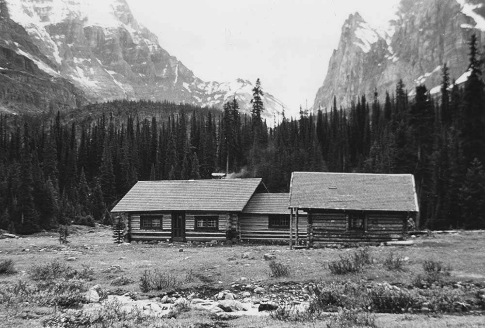
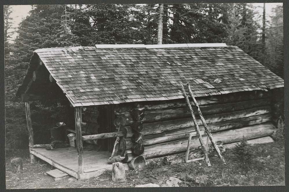
Existing huts, hut photos
https://archives.whyte.org/en/permalink/descriptions6577
- Part Of
- Alpine Club of Canada fonds
- Scope & Content
- File includes letters and photographs, slides, and negatives of huts.
- Date Range
- 1964-1979
- Reference Code
- M200 / AC 421 / 161
- V14 / AC 421P / 106 - 161
- Description Level
- 5 / File
- GMD
- Photograph
- Photograph print
1 image
- Part Of
- Alpine Club of Canada fonds
- Description Level
- 5 / File
- Fonds Number
- M200 / S6 / V14
- Series
- I.A.2.e. Administration: huts / properties
- Sous-Fonds
- V14
- Accession Number
- 5200
- Reference Code
- M200 / AC 421 / 161
- V14 / AC 421P / 106 - 161
- Date Range
- 1964-1979
- Physical Description
- 1 file of textual records. -- 55 photographs (47 prints, 6 negatives, 2 transparencies).
- Scope & Content
- File includes letters and photographs, slides, and negatives of huts.
- Name Access
- Alpine Club of Canada
- Subject Access
- Abbot Pass Hut
- Activities
- Administration
- Advertising
- Alpine Club of Canada
- Alpine Club House
- Cabins
- Cabins and shelters
- Camps
- Club
- Competition
- Discovery and exploration
- Environment
- Environment and Nature
- Exploration
- Guide
- Guides
- Hiking
- Huts
- Mountain
- Mountain guides
- Mountaineering
- Mountaineers
- Mountains
- National parks and reserves
- Organizations
- Photography
- Scenery
- Sports and recreation
- Summit
- Geographic Access
- Banff National Park
- Jasper National Park
- Yoho National Park
- Alberta
- British Columbia
- Canada
- Access Restrictions
- Access to negatives is by appointment only
- Language
- English
- Title Source
- Title based on contents of file
- Processing Status
- Processed
Images
This material is presented as originally created; it may contain outdated cultural descriptions and
potentially offensive content.
Read more.
- Part Of
- Murray Hay fonds
- Scope & Content
- File consists of 2 prints : col. ; 35 x 28 cm. File pertains to Murray Hay's rendering of Marmot Basin ski area in Jasper National Park. File includes two iterations of reproduction draft prints of Hay's map of Marmot Basin.
- Date Range
- ca.1976-ca.2000
- Reference Code
- V795 / II / B / i / 1
- Description Level
- 5 / File
- GMD
- Map
- Private record
- Part Of
- Murray Hay fonds
- Description Level
- 5 / File
- Fonds Number
- M570 / V795
- Series
- V795 / II : Unpublished Material
- Sous-Fonds
- V795
- Sub-Series
- V795 / II / B : Alberta / i : Jasper National Park
- Accession Number
- 2019.41
- Reference Code
- V795 / II / B / i / 1
- GMD
- Map
- Private record
- Date Range
- ca.1976-ca.2000
- Physical Description
- 2 prints : col. ; 35 x 28 cm
- Scope & Content
- File consists of 2 prints : col. ; 35 x 28 cm. File pertains to Murray Hay's rendering of Marmot Basin ski area in Jasper National Park. File includes two iterations of reproduction draft prints of Hay's map of Marmot Basin.
- Name Access
- Hay, Murray
- Subject Access
- Advertising
- Artist
- Ski Maps
- Ski area
- Map
- Cartography
- Sports and recreation
- Tourism
- Tourist information
- Winter
- Winter sports
- Geographic Access
- Jasper Marmot Basin
- Jasper National Park
- Alberta
- Canada
- Canadian Rocky Mountains
- Language
- English
- Related Material
- M570 / III / B / iii / 1
- Creator
- Hay, Murray
- Title Source
- Title based on contents of file
- Processing Status
- Processed
This material is presented as originally created; it may contain outdated cultural descriptions and
potentially offensive content.
Read more.
Margaret Oliver fonds
https://archives.whyte.org/en/permalink/descriptions55186
- Part Of
- Margaret Oliver fonds
- Scope & Content
- Fonds consists of transparency slides, maps, handwritten notes and club records, song books, and scrapbooks pertaining to Margaret Ruth Oliver and the Tuesday Hikers club.
- Date Range
- 1971-2010
- Reference Code
- M569 / V793
- Description Level
- 1 / Fonds
- GMD
- Textual record
- Photograph
- Transparency
- Published record
- Private record
- Scrapbook
- Map
- Organization record
- Part Of
- Margaret Oliver fonds
- Description Level
- 1 / Fonds
- Fonds Number
- M569 / V793
- Sous-Fonds
- M569
- V793
- Accession Number
- 2017.8656
- Reference Code
- M569 / V793
- GMD
- Textual record
- Photograph
- Transparency
- Published record
- Private record
- Scrapbook
- Map
- Organization record
- Date Range
- 1971-2010
- Physical Description
- 28 photographs : col. slides -- 1.5 m of textual records (3 binders -- 1 record book -- 10 song books -- maps, annotated -- 11 scrapbooks)
- History / Biographical
- Margaret Ruth Oliver was born on December 19, 1927 to parents Edgar and Gladys (Brazier) Hammett in Winnipeg, Manitoba. Margaret's siblings include Dorothy (1922), Muriel "Miv" (1923), John (1929), and Jean (1933). Margaret graduated from United College (Winnipeg) in 1949 with a B.Sc. degree, and worked as an Assistant Librarian at the University of Manitoba afterwards. Margaret later enrolled in a Laboratory Technician program at the University of Manitoba Medical College. Margaret married Thomas Albert Oliver, a fellow University of Manitoba alumnus, on September 25, 1954. The couple moved to Calgary for work (Thomas taught at the University of Calgary, and Margaret worked for a geophysical company). Margaret travelled extensively following the death of her husband in 1997, visiting places such as Nepal, Cambodia, Russia, Egypt and Greenland. In 1971, Margaret formed a hiking group within the University Faculty Women's Club (F.W.C.) through the University of Calgary. In 1976, this group became a private club called the Tuesday Hikers, which no longer held any affiliation to the F.W.C. Trips included weekly hikes and/or ski trips, as well as longer backpacking excursions.The club is still active as of 2022.
- Scope & Content
- Fonds consists of transparency slides, maps, handwritten notes and club records, song books, and scrapbooks pertaining to Margaret Ruth Oliver and the Tuesday Hikers club.
- Notes
- Materials are unprocessed and stored in three boxes: Box 1: 1 envelope "T. Hikers' Slides" - 28 film transparencies and printed notes; various maps with handwritten notes Box 2: 1 record book "T.H. Record Book" - handwritten lists and statistics of trips, attendance, miles; 2 binders with handwritten notes, titled "National Parks - Banff and Assiniboine" and "Nat'l Parks - Glacier + Jasper" Box 3: 1 binder titled "Tues. Hikers- Past Members and Guests"; 10 song books; trail, park and road maps; 11 scrapbooks, 1971-2010
- Name Access
- Oliver, Margaret
- Subject Access
- Hiking
- Travel
- Recreation
- Club
- Map
- Trails
- Music
- Entertainment
- Geography
- Geographic Access
- Canada
- Alberta
- Banff National Park
- Jasper National Park
- Assiniboine
- British Columbia
- Glacier National Park
- Language
- English
- Biographical Source Notes
- https://biblio.uottawa.ca/en/node/16056
- Title Source
- Title based on content in fonds
- Processing Status
- Unprocessed
This material is presented as originally created; it may contain outdated cultural descriptions and
potentially offensive content.
Read more.
Club photographs
https://archives.whyte.org/en/permalink/descriptions7214
- Part Of
- Alpine Club of Canada fonds
- Scope & Content
- Includes photographs of ACC property at Mount Assiniboine (accompanied by 2 maps - AC 018P); clubhouse view; move of library to Vancouver Public Library; Board meeting; closing party at the old clubhouse (AC 421P / 09-37); office staff.
- Date Range
- 1953-1983
- Reference Code
- V14 / AC 018P / 1-7
- V14 / AC 041P / 1
- V14 / AC 345P / 1-3
- V14 / AC 363P / 1
- V14 / AC 421P / 09-37
- V14 / AC 421P / 52-53
- Description Level
- 5 / File
- GMD
- Photograph
- Photograph print
5 images
- Part Of
- Alpine Club of Canada fonds
- Description Level
- 5 / File
- Fonds Number
- M200 / S6 / V14
- Series
- I.A.2.i. Administration: photography and photographs
- Sous-Fonds
- V14
- Accession Number
- 5200
- Reference Code
- V14 / AC 018P / 1-7
- V14 / AC 041P / 1
- V14 / AC 345P / 1-3
- V14 / AC 363P / 1
- V14 / AC 421P / 09-37
- V14 / AC 421P / 52-53
- Date Range
- 1953-1983
- Physical Description
- ca.44 photographs : prints
- Scope & Content
- Includes photographs of ACC property at Mount Assiniboine (accompanied by 2 maps - AC 018P); clubhouse view; move of library to Vancouver Public Library; Board meeting; closing party at the old clubhouse (AC 421P / 09-37); office staff.
- Name Access
- Alpine Club of Canada
- Subject Access
- Abbot Pass Hut
- Activities
- Administration
- Advertising
- Alpine Club of Canada
- Alpine Club House
- Cabins
- Cabins and shelters
- Camps
- Club
- Competition
- Discovery and exploration
- Environment
- Environment and Nature
- Exploration
- Guide
- Guides
- Hiking
- Huts
- Mountain
- Mountain guides
- Mountaineering
- Mountaineers
- Mountains
- Mount Assiniboine
- National parks and reserves
- Organizations
- Photography
- Scenery
- Sports and recreation
- Summit
- Geographic Access
- Banff National Park
- Jasper National Park
- Yoho National Park
- Alberta
- British Columbia
- Canada
- Language
- English
- Title Source
- Title based on material
- Processing Status
- Processed
Images


This material is presented as originally created; it may contain outdated cultural descriptions and
potentially offensive content.
Read more.