Narrow Results By
- Luxton family fonds 102
- Moore family fonds 36
- Nicholas Morant fonds 16
- Kidney family fonds 11
- Malcolm Geddes fonds 11
- Alpine Club of Canada fonds 9
- Archives General File Collection 8
- Dorothy Wardle fonds 6
- John Murray Gibbon fonds 6
- Aileen Harmon fonds 5
- Crosby family fonds 4
- Elmer and Grace Charlton fonds 4
Byron Harmon house fonds
https://archives.whyte.org/en/permalink/descriptions207
- Part Of
- Byron Harmon house fonds
- Scope & Content
- Fonds consists of plans of elevations and details of residence for Byron Harmon, by Benjamin S. Parker, architect, San Marino, California. The residence was built on St. Julien Road at Banff.
- Date Range
- 1929
- Reference Code
- M256
- Description Level
- 1 / Fonds
- GMD
- Textual record
- Plan
- Part Of
- Byron Harmon house fonds
- Description Level
- 1 / Fonds
- Fonds Number
- M 256
- Sous-Fonds
- M 256
- Accession Number
- 1821
- Reference Code
- M256
- GMD
- Textual record
- Plan
- Date Range
- 1929
- Physical Description
- 7 textual records
- History / Biographical
- Byron Harmon, 1876-1942, was a professional photographer at Banff, Alberta, Canada.
- Scope & Content
- Fonds consists of plans of elevations and details of residence for Byron Harmon, by Benjamin S. Parker, architect, San Marino, California. The residence was built on St. Julien Road at Banff.
- Name Access
- Harmon, Byron
- Parker, Benjamin S.
- Subject Access
- Buildings and facilities
- Family and personal life
- Access Restrictions
- No restrictions on access
- Copyright, privacy, commercial use and other restrictions may apply
- Language
- Language is English
- Related Material
- The Byron Harmon fonds (V263) contains Harmon's professional work as a photographer.
- Creator
- Harmon, Byron
- Category
- Family and personal life
- Title Source
- Title based on items.
- Processing Status
- Processed
This material is presented as originally created; it may contain outdated cultural descriptions and
potentially offensive content.
Read more.
[Northwest Territories]
https://archives.whyte.org/en/permalink/catalogue24375
- Medium
- Library - Maps and blueprints (unannotated; published)
- Map
- Published Date
- 1929
- Publisher
- Dept. of the Interior
- Call Number
- C8-3.1
- Publisher
- Dept. of the Interior
- Published Date
- 1929
- Physical Description
- 1 map : col
- Scale
- Scale: 60 miles to 1 inch
- Subjects
- Northwest Territories
- Notes
- R.C.M.P. posts, Radio Stations, Trading Posts, Boundaries and Names of Preserves
- Call Number
- C8-3.1
- Collection
- Archives Library
This material is presented as originally created; it may contain outdated cultural descriptions and
potentially offensive content.
Read more.
[Chipewyan, Alberta] Topographical Survey
https://archives.whyte.org/en/permalink/catalogue24413
- Medium
- Library - Maps and blueprints (unannotated; published)
- Map
- Published Date
- 1929
- Publisher
- Dept. of the Interior
- Call Number
- C9-2.1
- Publisher
- Dept. of the Interior
- Published Date
- 1929
- Physical Description
- 1 map : col
- Scale
- Scale: 4 miles: 1 inch
- Relief: Spot heights
- Subjects
- Chipewyan, Alberta
- Accession Number
- 400
- Call Number
- C9-2.1
- Collection
- Archives Library
This material is presented as originally created; it may contain outdated cultural descriptions and
potentially offensive content.
Read more.
[Stikine River, Northern B.C.]
https://archives.whyte.org/en/permalink/catalogue24528
- Medium
- Library - Maps and blueprints (unannotated; published)
- Map
- Published Date
- 1929
- Publisher
- Department of Lands, B.C.
- Call Number
- C10-3.6
- Publisher
- Department of Lands, B.C.
- Published Date
- 1929
- Scale
- Scale: 5 miles: 1 inch
- Relief: contour interval 500 ft.
- Subjects
- Northern British Columbia
- Stikine River
- Accession Number
- 495
- Call Number
- C10-3.6
- Collection
- Archives Library
This material is presented as originally created; it may contain outdated cultural descriptions and
potentially offensive content.
Read more.
[Europe and the Near East]
https://archives.whyte.org/en/permalink/catalogue24854
- Medium
- Library - Maps and blueprints (unannotated; published)
- Map
- Published Date
- 1929
- Publisher
- National Geographic Society
- Call Number
- C13-12.1
- Publisher
- National Geographic Society
- Published Date
- 1929
- Scale
- 94.7 miles to 1 inch
- Subjects
- Europe and the Near East
- Accession Number
- 400
- Call Number
- C13-12.1
- Collection
- Archives Library
This material is presented as originally created; it may contain outdated cultural descriptions and
potentially offensive content.
Read more.
Banff National Park, Yoho Park and Kootenay Park
https://archives.whyte.org/en/permalink/catalogue21447
- Medium
- Library - Maps and blueprints (unannotated; published)
- Map
- Published Date
- 1929
- Publisher
- Canadian Pacific Railway
- Call Number
- C3-6.3(a)
- Publisher
- Canadian Pacific Railway
- Published Date
- 1929
- Physical Description
- Colour
- Subjects
- Canadian Rockies
- Notes
- Panoramic map showing main and branch lines of C.P.R.
- 3 duplicates in Map Room
- Accession Number
- 131
- 110
- 1120
- 3072
- Call Number
- C3-6.3(a)
- Collection
- Archives Library
This material is presented as originally created; it may contain outdated cultural descriptions and
potentially offensive content.
Read more.
[Rocky Mountains and Jasper Parks] Showing areas which it is proposed to withdraw from
https://archives.whyte.org/en/permalink/catalogue23194
- Medium
- Library - Maps and blueprints (unannotated; published)
- Map
- Published Date
- 1929
- Publisher
- Dept. of the Interior
- Call Number
- C2-3.8
- Publisher
- Dept. of the Interior
- Published Date
- 1929
- Physical Description
- 1 map : col
- Scale
- Scale: 1:792,000
- Subjects
- Rocky Mountains and Jasper Parks
- Accession Number
- 1230
- Call Number
- C2-3.8
- Collection
- Archives Library
This material is presented as originally created; it may contain outdated cultural descriptions and
potentially offensive content.
Read more.
(Canmore area)
https://archives.whyte.org/en/permalink/catalogue24469
- Medium
- Library - Maps and blueprints (unannotated; published)
- Map
- Published Date
- October 22, 1928
- Publisher
- Dept. of the Interior
- Call Number
- C9-7.24
- Publisher
- Dept. of the Interior
- Published Date
- October 22, 1928
- Physical Description
- 1 map : black and white
- Scale
- 40 chains: 1 "
- Accession Number
- SG7500
- Call Number
- C9-7.24
- Collection
- Archives Library
This material is presented as originally created; it may contain outdated cultural descriptions and
potentially offensive content.
Read more.
[Northern Peace River Sheet] Pre-emptor's map
https://archives.whyte.org/en/permalink/catalogue24525
- Medium
- Library - Maps and blueprints (unannotated; published)
- Map
- Published Date
- 1928
- Publisher
- Department of Lands, B.C.
- Call Number
- C10-3.3
- Publisher
- Department of Lands, B.C.
- Published Date
- 1928
- Scale
- Scale: 4 miles: 1 inch
- Subjects
- British Columbia
- Northern Peace River
- Accession Number
- 495
- Call Number
- C10-3.3
- Collection
- Archives Library
This material is presented as originally created; it may contain outdated cultural descriptions and
potentially offensive content.
Read more.
- Medium
- Library - Maps and blueprints (unannotated; published)
- Map
- Published Date
- 1928
- Publisher
- Source: Canadian Geographica Survey
- Call Number
- C3-4.2
- Publisher
- Source: Canadian Geographica Survey
- Published Date
- 1928
- Scale
- Scale: 2 miles to 1 inch
- Relief: Contour interval 200'
- Subjects
- Windermere
- Accession Number
- 400
- Call Number
- C3-4.2
- Collection
- Archives Library
This material is presented as originally created; it may contain outdated cultural descriptions and
potentially offensive content.
Read more.
Boston in picture and story
https://archives.whyte.org/en/permalink/catalogue21516
- Medium
- Library - Maps and blueprints (unannotated; published)
- Map
- Published Date
- 1928
- Call Number
- C13-1.14
- Published Date
- 1928
- Subjects
- Boston, United States
- Notes
- 300 years of progress
- Accession Number
- 400
- Call Number
- C13-1.14
- Collection
- Archives Library
This material is presented as originally created; it may contain outdated cultural descriptions and
potentially offensive content.
Read more.
Kootenay Park
https://archives.whyte.org/en/permalink/catalogue23208
- Medium
- Library - Maps and blueprints (unannotated; published)
- Map
- Published Date
- 1928
- Publisher
- Ottawa: Office of the Surveyor General
- Call Number
- C2-5.3a
- Publisher
- Ottawa: Office of the Surveyor General
- Published Date
- 1928
- Physical Description
- 1 map : col
- Scale
- Scale: 1:126,720
- Subjects
- Kootenay National Park
- Accession Number
- 3206
- Call Number
- C2-5.3a
- Collection
- Archives Library
This material is presented as originally created; it may contain outdated cultural descriptions and
potentially offensive content.
Read more.
[Waterton Lakes Park]
https://archives.whyte.org/en/permalink/catalogue23215
- Medium
- Library - Maps and blueprints (unannotated; published)
- Map
- Published Date
- 1928
- Publisher
- Dept. of Mines and Technical Surveys
- Call Number
- C2-6.4(a)
- Publisher
- Dept. of Mines and Technical Surveys
- Published Date
- 1928
- Physical Description
- 1 map : col
- Scale
- Scale: 1 mile to 1 inch
- Subjects
- Waterton Lakes National Park
- Accession Number
- 2781
- Call Number
- C2-6.4(a)
- Collection
- Archives Library
This material is presented as originally created; it may contain outdated cultural descriptions and
potentially offensive content.
Read more.
Waterton Lakes Park
https://archives.whyte.org/en/permalink/catalogue23216
- Medium
- Library - Maps and blueprints (unannotated; published)
- Map
- Published Date
- 1928
- Publisher
- Ottawa : Topographical Survey of Canada
- Call Number
- C2-6.4b
- Publisher
- Ottawa : Topographical Survey of Canada
- Published Date
- 1928
- Physical Description
- 1 map : col
- Scale
- Scale: 1:63,360
- Subjects
- Waterton Lakes National Park
- Accession Number
- 3206
- Call Number
- C2-6.4b
- Collection
- Archives Library
This material is presented as originally created; it may contain outdated cultural descriptions and
potentially offensive content.
Read more.
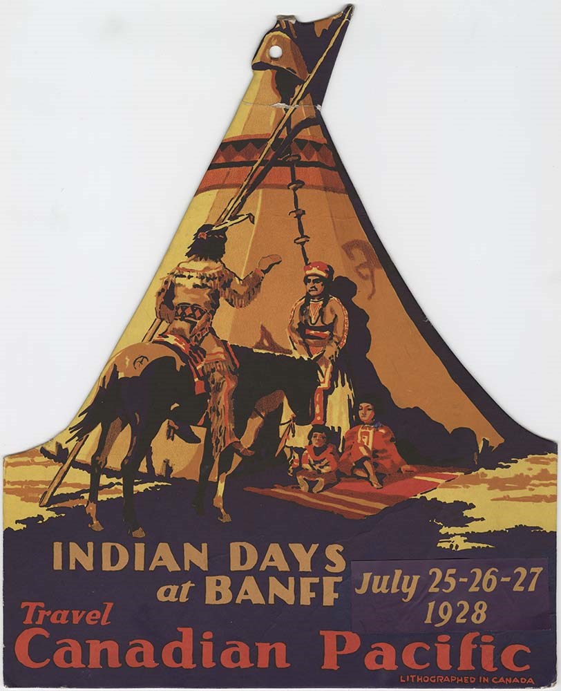
Banff Indian Days 1928 poster
https://archives.whyte.org/en/permalink/descriptions54784
- Part Of
- Luxton family fonds
- Scope & Content
- File consists of one lithograph colour poster advertisement for Banff Indian Days celebrations in 1928, promoted by Canadian Pacific. Poster depicts four Indigenous people outside of teepee [one man on horseback, one woman standing, two children sitting] with text in large print at bottom.
- Date Range
- 1928
- Reference Code
- LUX / II / F1 / 47
- Description Level
- 5 / File
- GMD
- Textual record
- Published record
- Poster
1 image
- Part Of
- Luxton family fonds
- Description Level
- 5 / File
- Fonds Number
- LUX
- Series
- LUX / II / F : Collected material
- Sous-Fonds
- LUX / II : Eleanor Luxton sous-fonds
- Sub-Series
- LUX / II / F1 : Textual
- Accession Number
- LUX
- Reference Code
- LUX / II / F1 / 47
- Responsibility
- Produced by Canadian Pacific
- Date Range
- 1928
- Physical Description
- 1 col. lithography poster on cardboard; 27 x 33 cm
- Scope & Content
- File consists of one lithograph colour poster advertisement for Banff Indian Days celebrations in 1928, promoted by Canadian Pacific. Poster depicts four Indigenous people outside of teepee [one man on horseback, one woman standing, two children sitting] with text in large print at bottom.
- Material Details
- Poster has foldable cardboard stand at back to place upright on surface
- Name Access
- Canadian Pacific Railway
- Subject Access
- Activities
- Advertising
- Cultural pluralism
- Community events
- Banff Indian Days
- Indigenous Peoples
- Tourism
- Geographic Access
- Canada
- Alberta
- Banff
- Language
- English
- Title Source
- Title based on contents of file
- Processing Status
- Processed
Images
This material is presented as originally created; it may contain outdated cultural descriptions and
potentially offensive content.
Read more.
Geographic Board of Canada Map
https://archives.whyte.org/en/permalink/catalogue24354
- Medium
- Library - Maps and blueprints (unannotated; published)
- Map
- Published Date
- 1927
- Publisher
- Geographic Board of Canada
- Call Number
- C6-7.5(a)
- Publisher
- Geographic Board of Canada
- Published Date
- 1927
- Scale
- 35 miles to 1 inch
- Subjects
- Alberta
- Notes
- Illustrating "Place Names of Alberta"
- Accession Number
- 576
- Call Number
- C6-7.5(a)
- Collection
- Archives Library
This material is presented as originally created; it may contain outdated cultural descriptions and
potentially offensive content.
Read more.
- Medium
- Library - Maps and blueprints (unannotated; published)
- Map
- Published Date
- 1927
- Publisher
- Dept. of the Interior, Ottawa
- Call Number
- C9-1.2
- Publisher
- Dept. of the Interior, Ottawa
- Published Date
- 1927
- Physical Description
- 1 map: col
- Scale
- Scale: 12 1/2 miles: 1 inch
- Subjects
- Alberta
- Accession Number
- 400
- Call Number
- C9-1.2
- Collection
- Archives Library
This material is presented as originally created; it may contain outdated cultural descriptions and
potentially offensive content.
Read more.
Canadian Pacific Railway and connecting lines
https://archives.whyte.org/en/permalink/catalogue24565
- Medium
- Library - Maps and blueprints (unannotated; published)
- Map
- Published Date
- 1927
- Publisher
- [Montreal] : C.P.R.
- Call Number
- C11-3.17
- Publisher
- [Montreal] : C.P.R.
- Published Date
- 1927
- Physical Description
- 1 map : col
- Scale
- 1 inch = 110 miles
- Subjects
- Canadian Pacific Railway
- Accession Number
- 6596
- Call Number
- C11-3.17
- Collection
- Archives Library
This material is presented as originally created; it may contain outdated cultural descriptions and
potentially offensive content.
Read more.
Topographical Map
https://archives.whyte.org/en/permalink/catalogue24618
- Medium
- Library - Maps and blueprints (unannotated; published)
- Map
- Published Date
- 1927
- Publisher
- Dept. of the Interior
- Call Number
- C3-2.3
- Publisher
- Dept. of the Interior
- Published Date
- 1927
- Physical Description
- Colour
- Scale
- Scale: 1:63,360
- Relief: Contour interval 100ft.
- Subjects
- Lake Louise
- Notes
- Duplicates (3) in Map Room
- Accession Number
- 626
- 3069
- 3349
- 400 (2)
- 1113 (1)
- Call Number
- C3-2.3
- Collection
- Archives Library
This material is presented as originally created; it may contain outdated cultural descriptions and
potentially offensive content.
Read more.
Map of the mountains from Calgary to Sicamous
https://archives.whyte.org/en/permalink/catalogue21446
- Medium
- Library - Maps and blueprints (unannotated; published)
- Map
- Published Date
- 1927
- Publisher
- Canadian Pacific Railway
- Call Number
- C3-6.2
- Publisher
- Canadian Pacific Railway
- Published Date
- 1927
- Physical Description
- Colour
- Subjects
- Canadian Pacific Rockies
- Notes
- Panoramic map
- Accession Number
- 74
- 3069
- 2933
- Call Number
- C3-6.2
- Collection
- Archives Library
This material is presented as originally created; it may contain outdated cultural descriptions and
potentially offensive content.
Read more.