Narrow Results By
- Peter Whyte (1905 – 1966, Canadian) 119
- Catharine Robb Whyte, O. C. (1906 – 1979, Canadian) 114
- Andreas Roth 3
- Belmore Browne (1880 – 1954, American) 3
- Carl Clemens Moritz Rungius (1869 – 1959, American) 3
- Aldro T. Hibbard (1886 – 1972, American) 2
- Alfred Crocker Leighton, R. C. A. (1901 – 1965, Canadian) 2
- Cornelius David Krieghoff (1815 – 1872, Canadian) 2
- MacKay, B.R. 2
- Morant, Nicholas 2
- Robert J. McGuinness (1886 – 1961, Canadian) 2
- Schaffer, Mary 2
[Hightower Creek - Alberta]
https://archives.whyte.org/en/permalink/catalogue23660
- Medium
- Library - Maps and blueprints (unannotated; published)
- Map
- Published Date
- 1949
- Publisher
- Dept. of Mines & Technical Surv.
- Call Number
- NTS
- 83F/13E
- Publisher
- Dept. of Mines & Technical Surv.
- Published Date
- 1949
- Scale
- 1:50,000
- Subjects
- Hightower Creek - Alberta
- Notes
- National Topographic System
- Accession Number
- 12000
- Call Number
- NTS
- 83F/13E
- Collection
- Archives Library
This material is presented as originally created; it may contain outdated cultural descriptions and
potentially offensive content.
Read more.
[Hightower Creek - Alberta]
https://archives.whyte.org/en/permalink/catalogue23661
- Medium
- Library - Maps and blueprints (unannotated; published)
- Map
- Published Date
- 1949
- Publisher
- Dept. of Mines & Technical Survey
- Call Number
- NTS
- 83F/13W
- Publisher
- Dept. of Mines & Technical Survey
- Published Date
- 1949
- Scale
- 1:50,000
- Subjects
- Hightower Creek - Alberta
- Notes
- National Topographic System
- Accession Number
- 12000
- Call Number
- NTS
- 83F/13W
- Collection
- Archives Library
This material is presented as originally created; it may contain outdated cultural descriptions and
potentially offensive content.
Read more.
Topographical Map
https://archives.whyte.org/en/permalink/catalogue24619
- Medium
- Library - Maps and blueprints (unannotated; published)
- Map
- Published Date
- 1948
- Publisher
- Dept. of Mines and Resources
- Call Number
- C3-2.4
- Publisher
- Dept. of Mines and Resources
- Published Date
- 1948
- Physical Description
- Colour
- Scale
- Scale: 1:63,360
- Relief: Contour interval 100'
- Subjects
- Lake Louise
- Accession Number
- 1105
- Call Number
- C3-2.4
- Collection
- Archives Library
This material is presented as originally created; it may contain outdated cultural descriptions and
potentially offensive content.
Read more.
- Date
- 1948
- Medium
- oil on board
- Catalogue Number
- LoT.02.09
- Description
- The bottom two thirds is a marshy scene with water, shrubs and a beaver dam; greens, yellow and oranges; the right side has a tall tree; the top third is mountain slopes with a snow covered mountain down the valley.
- Title
- Untitled
- Date
- 1948
- Medium
- oil on board
- Dimensions
- 35.4 x 38.2 cm
- Description
- The bottom two thirds is a marshy scene with water, shrubs and a beaver dam; greens, yellow and oranges; the right side has a tall tree; the top third is mountain slopes with a snow covered mountain down the valley.
- Subject
- landscape, mountain
- Credit
- Gift of Mary and William Allan, Calgary, 1989
- Catalogue Number
- LoT.02.09
This material is presented as originally created; it may contain outdated cultural descriptions and
potentially offensive content.
Read more.
Province of Alberta
https://archives.whyte.org/en/permalink/catalogue24409
- Medium
- Library - Maps and blueprints (unannotated; published)
- Map
- Published Date
- 1947
- Publisher
- Alberta Dept. of Lands and Mines
- Call Number
- C9-1.19
- Publisher
- Alberta Dept. of Lands and Mines
- Published Date
- 1947
- Physical Description
- 1 map
- Scale
- Scale: 1 inch = 16 miles
- Subjects
- Alberta
- Notes
- In oversize cabinet (rolled up)
- Accession Number
- 6406
- Call Number
- C9-1.19
- Collection
- Archives Library
This material is presented as originally created; it may contain outdated cultural descriptions and
potentially offensive content.
Read more.
Topographic Map
https://archives.whyte.org/en/permalink/catalogue24621
- Medium
- Library - Maps and blueprints (unannotated; published)
- Map
- Published Date
- 1947
- Publisher
- Dept. of Mines and Resources
- Call Number
- C3-3.1
- Publisher
- Dept. of Mines and Resources
- Published Date
- 1947
- Physical Description
- Colour
- Scale
- Scale: 1": 1 mile
- Relief: Contour interval 100'
- Subjects
- Sunwapta
- Accession Number
- 442
- Call Number
- C3-3.1
- Collection
- Archives Library
This material is presented as originally created; it may contain outdated cultural descriptions and
potentially offensive content.
Read more.
Jasper Park South Sheet
https://archives.whyte.org/en/permalink/catalogue23180
- Medium
- Library - Maps and blueprints (unannotated; published)
- Map
- Published Date
- 1947
- Publisher
- Dept. of Mines and Resources
- Call Number
- C2-2.7
- Publisher
- Dept. of Mines and Resources
- Published Date
- 1947
- Scale
- Scale: 3 miles to 1 inch
- Notes
- Relief: Contour Interval 200'
- Accession Number
- 400, 718
- Call Number
- C2-2.7
- Collection
- Archives Library
This material is presented as originally created; it may contain outdated cultural descriptions and
potentially offensive content.
Read more.
[Jasper Park]
https://archives.whyte.org/en/permalink/catalogue23181
- Medium
- Library - Maps and blueprints (unannotated; published)
- Map
- Published Date
- 1947
- Publisher
- Dept. of Mines and Technical Surveys
- Call Number
- C2-2.8
- Publisher
- Dept. of Mines and Technical Surveys
- Published Date
- 1947
- Physical Description
- 1 map : col
- Scale
- Scale: 1 inch : 3 miles
- Relief: Contour Interval 200 ft
- Subjects
- Jasper National Park
- Notes
- Dup. in Research Room/2 Dup. in Map Room
- Accession Number
- 3000
- 673
- 1153 M. 171
- 1096
- 3349
- Call Number
- C2-2.8
- Collection
- Archives Library
This material is presented as originally created; it may contain outdated cultural descriptions and
potentially offensive content.
Read more.
[Jasper Park (South Sheet)]
https://archives.whyte.org/en/permalink/catalogue23182
- Medium
- Library - Maps and blueprints (unannotated; published)
- Map
- Published Date
- 1947 (interim corrections 1974)
- Publisher
- Department of Mines and Technical Surveys
- Call Number
- C2-2.8 (a)
- Publisher
- Department of Mines and Technical Surveys
- Published Date
- 1947 (interim corrections 1974)
- Physical Description
- 1 map : col
- Scale
- Scale: I inch: 3 miles
- Relief: Counter interval 200 ft.
- Subjects
- Jasper National Park
- Accession Number
- 7000
- Call Number
- C2-2.8 (a)
- Collection
- Archives Library
This material is presented as originally created; it may contain outdated cultural descriptions and
potentially offensive content.
Read more.
[Deep Valley Creek South, Alberta]
https://archives.whyte.org/en/permalink/catalogue23579
- Medium
- Library - Maps and blueprints (unannotated; published)
- Map
- Published Date
- 1947
- Publisher
- Dept. of Mines & Technical Survey
- Call Number
- NTS
- 82K/4E
- Publisher
- Dept. of Mines & Technical Survey
- Published Date
- 1947
- Scale
- Scale: 1:50,000
- Subjects
- Deep Valley Creek
- Alberta
- Notes
- National Topographic System
- Accession Number
- 12000
- Call Number
- NTS
- 82K/4E
- Collection
- Archives Library
This material is presented as originally created; it may contain outdated cultural descriptions and
potentially offensive content.
Read more.
[Deep Valley Creek South, Alberta]
https://archives.whyte.org/en/permalink/catalogue23580
- Medium
- Library - Maps and blueprints (unannotated; published)
- Map
- Published Date
- 1947
- Publisher
- Dept. of Mines & Technical Survey
- Call Number
- NTS
- 83K/4W
- Publisher
- Dept. of Mines & Technical Survey
- Published Date
- 1947
- Scale
- Scale: 1:50,000
- Subjects
- Deep Valley Creek
- Alberta
- Notes
- National Topographic System
- Accession Number
- 12000
- Call Number
- NTS
- 83K/4W
- Collection
- Archives Library
This material is presented as originally created; it may contain outdated cultural descriptions and
potentially offensive content.
Read more.
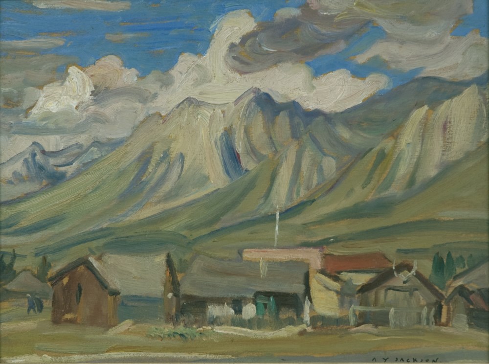
Canmore, Alberta
https://archives.whyte.org/en/permalink/artifactjaa.02.01
- Date
- 1947
- Medium
- oil on canvas
- Catalogue Number
- JaA.02.01
- Description
- General colour: green greys, blue. Cluster of buildings across the lower third. Mountains sweeps up behind to a clouded blue sky.
1 image
- Title
- Canmore, Alberta
- Date
- 1947
- Medium
- oil on canvas
- Dimensions
- 52.8 x 43.8 cm
- Description
- General colour: green greys, blue. Cluster of buildings across the lower third. Mountains sweeps up behind to a clouded blue sky.
- Credit
- Gift of Catharine Robb Whyte, O. C., Banff, 1977
- Catalogue Number
- JaA.02.01
- Notes
- Artistry Revealed: Peter Whyte, Catharine Robb Whyte and Their Contemporaries; June 17, 2018 to October 21, 2018
Images
This material is presented as originally created; it may contain outdated cultural descriptions and
potentially offensive content.
Read more.
[Moberly Creek - Alberta]
https://archives.whyte.org/en/permalink/catalogue23741
- Medium
- Library - Maps and blueprints (unannotated; published)
- Map
- Published Date
- 1946
- Publisher
- Dept. of Mines & Technical Surveys
- Call Number
- NTS
- 83E/9
- Publisher
- Dept. of Mines & Technical Surveys
- Published Date
- 1946
- Scale
- 1:50,000
- Subjects
- Moberly Creek - Alberta
- Notes
- National Topographic System
- Provisional Map
- Accession Number
- 12000
- Call Number
- NTS
- 83E/9
- Collection
- Archives Library
This material is presented as originally created; it may contain outdated cultural descriptions and
potentially offensive content.
Read more.
[United States]
https://archives.whyte.org/en/permalink/catalogue24812
- Medium
- Library - Maps and blueprints (unannotated; published)
- Map
- Published Date
- 1946
- Publisher
- National Geographic Society
- Call Number
- C13-1.1(d)
- Publisher
- National Geographic Society
- Published Date
- 1946
- Scale
- Scale: 78.91 miles to 1 inch
- Relief: Bench marks
- Subjects
- United States
- Accession Number
- 495
- Call Number
- C13-1.1(d)
- Collection
- Archives Library
This material is presented as originally created; it may contain outdated cultural descriptions and
potentially offensive content.
Read more.
[RECONNAISSANCE PLAN: BANFF_MT. ASSINIBOINE PARK ROUTE 4 via Healy Creek, Sunshine Lodge, Citadel Pass]
https://archives.whyte.org/en/permalink/catalogue24909
- Medium
- Library - Maps and blueprints (unannotated; published)
- Map
- Published Date
- 1946 (transfered to manuscript Oct. 1994)
- Call Number
- C2-10.1 (d)
- Published Date
- 1946 (transfered to manuscript Oct. 1994)
- Scale
- 1) Scale: 4 ": 1 mile
- Relief - Counter interval 50 ft.
- 2) Scale: 1 ": 200 ft.
- Relief - Counter interval: 5 ft.
- Subjects
- Mount Assiniboine Provincial Park
- Notes
- 2) = Plan of Healy Creek_Mt. Assiniboine Proposed Location Class "C" Highway Survey 1946/Section 1_Banff to Healy Creek
- 5) Sunshine to Quartz Hill
- 6) 3 sections
- Accession Number
- 2158
- Call Number
- C2-10.1 (d)
- Collection
- Archives Library
This material is presented as originally created; it may contain outdated cultural descriptions and
potentially offensive content.
Read more.
Map showing Coalfields, Potential Coal Areas and Coal occurences of Canada
https://archives.whyte.org/en/permalink/catalogue21472
- Medium
- Library - Book (including soft-cover and pamphlets)
- Map
- Published Date
- 1946
- Publisher
- Dept. of Mines and Resources
- Call Number
- C7-5.7
- Publisher
- Dept. of Mines and Resources
- Published Date
- 1946
- Subjects
- Canada - Coal Areas
- Accession Number
- 3071
- Call Number
- C7-5.7
- Collection
- Archives Library
This material is presented as originally created; it may contain outdated cultural descriptions and
potentially offensive content.
Read more.
Glacier Park, B.C.
https://archives.whyte.org/en/permalink/catalogue23225
- Medium
- Library - Maps and blueprints (unannotated; published)
- Map
- Published Date
- 1946
- Publisher
- Ottawa, Tophographical Survey of Canada
- Call Number
- C2-7.5a
- Publisher
- Ottawa, Tophographical Survey of Canada
- Published Date
- 1946
- Physical Description
- 1 map : col
- Scale
- Scale: 1:126,720
- Subjects
- Glacier National Park
- Accession Number
- 3349
- Call Number
- C2-7.5a
- Collection
- Archives Library
This material is presented as originally created; it may contain outdated cultural descriptions and
potentially offensive content.
Read more.
[Blairmore 82G/9 West, Alberta]
https://archives.whyte.org/en/permalink/catalogue23501
- Medium
- Library - Maps and blueprints (unannotated; published)
- Map
- Published Date
- 1946
- Publisher
- Dept. of Mines and Techinical Surveys
- Call Number
- NTS
- 82G/9W
- Publisher
- Dept. of Mines and Techinical Surveys
- Published Date
- 1946
- Physical Description
- 1 map : col
- Scale
- Scale: 1:50,000
- Relief: Contour interval 100'
- Subjects
- Blairmore
- Western Alberta
- Notes
- National Topographic System
- Call Number
- NTS
- 82G/9W
- Collection
- Archives Library
This material is presented as originally created; it may contain outdated cultural descriptions and
potentially offensive content.
Read more.
Georgia Engelhard
https://archives.whyte.org/en/permalink/artifactfoe.02.01
- Artist
- Edward Forn
- Date
- 1946
- Medium
- oil on canvas
- Catalogue Number
- FoE.02.01
- Description
- A woman, Georgia Engelhard, stands in the centre of the picture, her legs cut off at centre thigh at bottom of picture, she is wearing blue pants and red checkered shirt, a blue/green hat in her right hand at her waist, she is looking straight forward, short blond hair, blue eyes and rosy cheeks, …
1 image
- Artist
- Edward Forn
- Title
- Georgia Engelhard
- Date
- 1946
- Medium
- oil on canvas
- Dimensions
- 81.0 x 66.0 cm
- Description
- A woman, Georgia Engelhard, stands in the centre of the picture, her legs cut off at centre thigh at bottom of picture, she is wearing blue pants and red checkered shirt, a blue/green hat in her right hand at her waist, she is looking straight forward, short blond hair, blue eyes and rosy cheeks, the background top quarter is a cloudy sky, centre a range of mountains (Mount Assiniboine), a line of green and yellow trees, the bottom of the picture behind the lady is a lake
- Subject
- portrait
- female
- Georgia Engelhard
- Credit
- Gift of Eaton Cromwell, Bryn Mawr, USA, 1988
- Catalogue Number
- FoE.02.01
Images

This material is presented as originally created; it may contain outdated cultural descriptions and
potentially offensive content.
Read more.
[Waterton Lakes Park]
https://archives.whyte.org/en/permalink/catalogue23214
- Medium
- Library - Maps and blueprints (unannotated; published)
- Map
- Published Date
- 1945
- Publisher
- Dept. of Mines and Resources
- Call Number
- C2-6.4
- Publisher
- Dept. of Mines and Resources
- Published Date
- 1945
- Physical Description
- 1 map : col
- Scale
- Scale: 1 inch : 1 mile
- Contour Interval 100 ft.
- Subjects
- Waterton Lakes National Park
- Notes
- 1 duplicate - Accn. 2781
- Accession Number
- 718
- 2781
- Call Number
- C2-6.4
- Collection
- Archives Library
This material is presented as originally created; it may contain outdated cultural descriptions and
potentially offensive content.
Read more.