Narrow Results By
- Boorne and May fonds 106
- Luxton family fonds 65
- Joe Kootenay fonds 24
- Kidney family fonds 17
- Peter and Catharine Whyte fonds 16
- Eliza Hunter fonds 14
- Alpine Club of Canada fonds 8
- Malcolm Geddes fonds 4
- Walter S. Painter fonds 4
- Archives General File Collection 3
- Barbara Whyte fonds 3
- Bert Riggall fonds 3
Sectional map
https://archives.whyte.org/en/permalink/catalogue24461
- Medium
- Library - Maps and blueprints (unannotated; published)
- Map
- Published Date
- 1909
- Publisher
- Dept. of the Interior, Ottawa
- Call Number
- C9-6.1
- Publisher
- Dept. of the Interior, Ottawa
- Published Date
- 1909
- Scale
- 6 miles: 1 inch
- Subjects
- Pincher Creek Sheet
- Accession Number
- 400
- Call Number
- C9-6.1
- Collection
- Archives Library
This material is presented as originally created; it may contain outdated cultural descriptions and
potentially offensive content.
Read more.
Sectional map
https://archives.whyte.org/en/permalink/catalogue24462
- Medium
- Library - Maps and blueprints (unannotated; published)
- Map
- Published Date
- 1909
- Publisher
- Dept. of the Interior, Ottawa
- Call Number
- C9-6.2
- Publisher
- Dept. of the Interior, Ottawa
- Published Date
- 1909
- Scale
- 6 miles: 1 inch
- Subjects
- Lethbridge Sheet
- Accession Number
- 400
- Call Number
- C9-6.2
- Collection
- Archives Library
This material is presented as originally created; it may contain outdated cultural descriptions and
potentially offensive content.
Read more.
Sectional Map, Special Edition showing Lands disposed of
https://archives.whyte.org/en/permalink/catalogue24589
- Medium
- Library - Maps and blueprints (unannotated; published)
- Map
- Published Date
- 1909
- Call Number
- C11-6.12
- Published Date
- 1909
- Scale
- 6 miles - 1 inch
- Notes
- References: Trails, Trails surveyed, Post Offices, Railway Stations, Range numbers, Township numbers......
- Accession Number
- 400
- Call Number
- C11-6.12
- Collection
- Archives Library
This material is presented as originally created; it may contain outdated cultural descriptions and
potentially offensive content.
Read more.
CPR Plan and Profile of Line Change, Rogers Pass
https://archives.whyte.org/en/permalink/catalogue24796
- Medium
- Library - Maps and blueprints (unannotated; published)
- Map
- Published Date
- 1909
- Call Number
- C12-1.28
- Published Date
- 1909
- Scale
- 400 feet to the inch
- Subjects
- Rogers Pass
- Notes
- Photostatic copy from the B.C. Provincial Archives
- Accession Number
- 2353
- Call Number
- C12-1.28
- Collection
- Archives Library
This material is presented as originally created; it may contain outdated cultural descriptions and
potentially offensive content.
Read more.
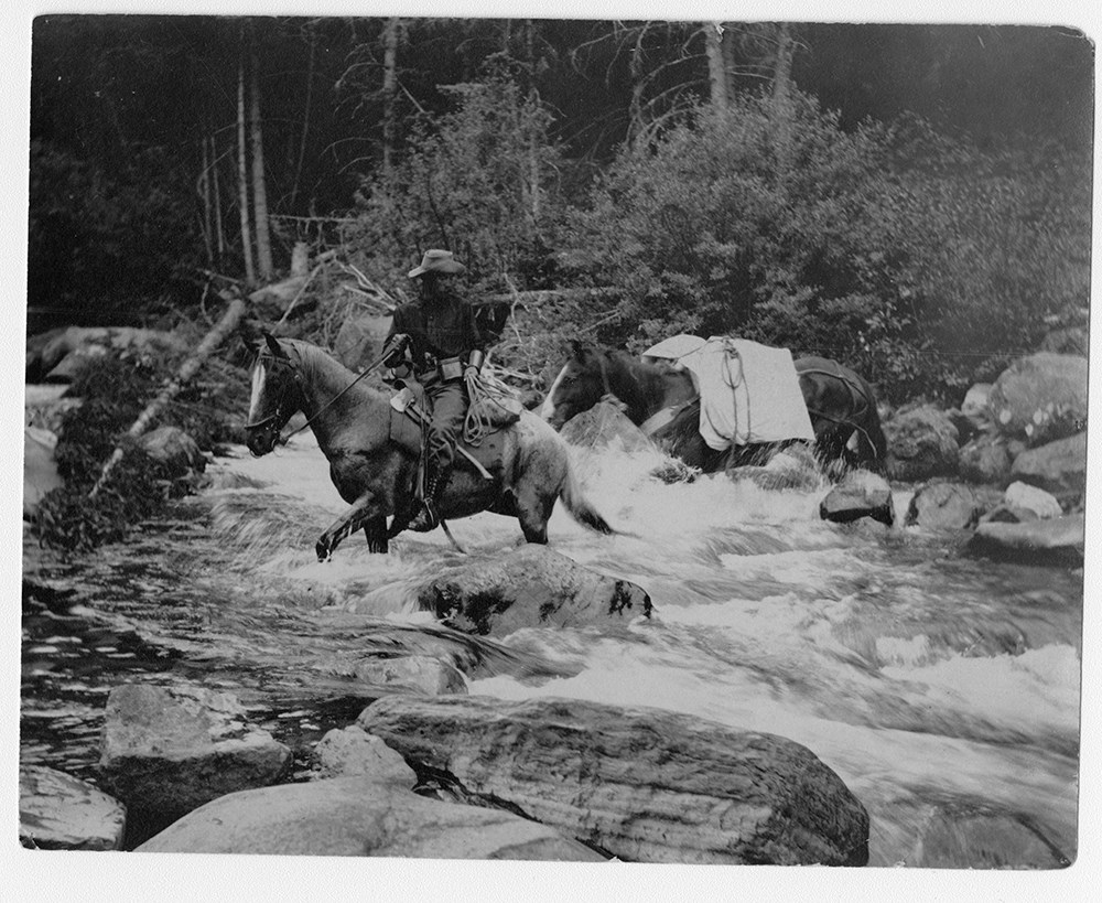
F.H. Riggall and packhourse crossing Boundary Creek
https://archives.whyte.org/en/permalink/descriptions53797
- Part Of
- Bert Riggall fonds
- Scope & Content
- Image depicts Bert Riggall and packhorse crossing Boundary Creek with Phillip R. Goodwin, artist of New York, in August, 1909.
- Date Range
- 1909
- Reference Code
- V26 / III / A1 / PA - 7
- Description Level
- 6 / Item
- GMD
- Photograph
- Photograph print
1 image
- Part Of
- Bert Riggall fonds
- Description Level
- 6 / Item
- Fonds Number
- M376 / V26
- Series
- III. Professional Photography: Guiding and Hunting Trips
- Sous-Fonds
- V26
- Sub-Series
- Goodwin and Proctor Trips
- Accession Number
- 7201
- Reference Code
- V26 / III / A1 / PA - 7
- Date Range
- 1909
- Physical Description
- 1 photograph : b&w print
- Scope & Content
- Image depicts Bert Riggall and packhorse crossing Boundary Creek with Phillip R. Goodwin, artist of New York, in August, 1909.
- Name Access
- Goodwin, Phillip R.
- Riggall, Bert
- Subject Access
- Environment and Nature
- Pack trips
- Exploration
- Horses
- Horse packing
- Geographic Access
- Canada
- British Columbia
- Boundary Creek
- Language
- N/A
- Title Source
- Title based on subject of item
- Processing Status
- Processed
Images
This material is presented as originally created; it may contain outdated cultural descriptions and
potentially offensive content.
Read more.
- Part Of
- Archives General File Collection
- Scope & Content
- File consists of one sketchbook. Sketch book consists of watercolour paintings
- Date Range
- 1909
- Reference Code
- M8 / 134
- Description Level
- 5 / File
- GMD
- Photograph
- Photograph print
- Part Of
- Archives General File Collection
- Description Level
- 5 / File
- Fonds Number
- M8 / V8 / S8
- Series
- 134
- Sous-Fonds
- M8
- Accession Number
- M8 / 134
- Reference Code
- M8 / 134
- Date Range
- 1909
- Physical Description
- 2.5 cm of textual records
- Scope & Content
- File consists of one sketchbook. Sketch book consists of watercolour paintings
- Name Access
- Welby, W.A
- Geographic Access
- Alberta
- Banff National Park
- Language
- English
- Creator
- Welby, W.A
- Title Source
- Title based on contents
- Processing Status
- Processed
This material is presented as originally created; it may contain outdated cultural descriptions and
potentially offensive content.
Read more.
Sectional map
https://archives.whyte.org/en/permalink/catalogue24463
- Medium
- Library - Maps and blueprints (unannotated; published)
- Map
- Published Date
- 1908
- Publisher
- Dept. of the Interior, Ottawa
- Call Number
- C9-6.3
- Publisher
- Dept. of the Interior, Ottawa
- Published Date
- 1908
- Scale
- 6 miles: 1 inch
- Subjects
- Porcupine Sheet
- Accession Number
- 400
- Call Number
- C9-6.3
- Collection
- Archives Library
This material is presented as originally created; it may contain outdated cultural descriptions and
potentially offensive content.
Read more.
Special edition map showing lands disposed of
https://archives.whyte.org/en/permalink/catalogue24586
- Medium
- Library - Maps and blueprints (unannotated; published)
- Map
- Published Date
- 1908
- Publisher
- Dept. of the Interior
- Call Number
- C11-6.9
- Publisher
- Dept. of the Interior
- Published Date
- 1908
- Scale
- 6 miles - 1 inch
- Subjects
- Canada - Prairie Region
- Manitoba
- Notes
- Sectional map
- References: Trails, Trails surveyed, Post Offices, Railway Stations, Range Numbers, Township numbers.....
- Accession Number
- 400
- Call Number
- C11-6.9
- Collection
- Archives Library
This material is presented as originally created; it may contain outdated cultural descriptions and
potentially offensive content.
Read more.
Special edition map showing lands disposed of
https://archives.whyte.org/en/permalink/catalogue24587
- Medium
- Library - Maps and blueprints (unannotated; published)
- Map
- Published Date
- 1908
- Publisher
- Dept. of the Interior
- Call Number
- C11-6.10
- Publisher
- Dept. of the Interior
- Published Date
- 1908
- Scale
- 6 miles - 1 inch
- Notes
- Sectional map
- References: Trails, Trails surveyed, Post Offices, Railway Stations, Range numbers, Township numbers...
- Accession Number
- 400
- Call Number
- C11-6.10
- Collection
- Archives Library
This material is presented as originally created; it may contain outdated cultural descriptions and
potentially offensive content.
Read more.
Special edition map showing lands disposed of
https://archives.whyte.org/en/permalink/catalogue24588
- Medium
- Library - Maps and blueprints (unannotated; published)
- Map
- Published Date
- 1908
- Publisher
- Dept. of the Interior
- Call Number
- C11-6.11
- Publisher
- Dept. of the Interior
- Published Date
- 1908
- Scale
- 6 miles - 1 inch
- Notes
- Sectional map
- References: Trails, Trails surveyed, Post Offices, Railway Stations, Range numbers, Township numbers....
- Accession Number
- 400
- Call Number
- C11-6.11
- Collection
- Archives Library
This material is presented as originally created; it may contain outdated cultural descriptions and
potentially offensive content.
Read more.
A sectional map, special edition showing Lands disposed of
https://archives.whyte.org/en/permalink/catalogue24590
- Medium
- Library - Maps and blueprints (unannotated; published)
- Map
- Published Date
- 1908
- Publisher
- Dept. of the Interior
- Call Number
- C11-6.13
- Publisher
- Dept. of the Interior
- Published Date
- 1908
- Scale
- 6 miles - 1 inch
- Notes
- References: Trails, Trails surveyed, Post Offices, Railway Stations, Range numbers, Township numbers....
- Accession Number
- 400
- Call Number
- C11-6.13
- Collection
- Archives Library
This material is presented as originally created; it may contain outdated cultural descriptions and
potentially offensive content.
Read more.
Sectional Map Showing Lands disposed of
https://archives.whyte.org/en/permalink/catalogue24591
- Medium
- Library - Maps and blueprints (unannotated; published)
- Map
- Published Date
- 1908
- Publisher
- Department of the Interior, Ottawa
- Call Number
- C11-6.14
- Publisher
- Department of the Interior, Ottawa
- Published Date
- 1908
- Scale
- 6 miles - 1 inch
- Notes
- References: Trails, Trails surveyed, Post Offices, Railway Stations, Range
- Accession Number
- 400
- Call Number
- C11-6.14
- Collection
- Archives Library
This material is presented as originally created; it may contain outdated cultural descriptions and
potentially offensive content.
Read more.
Sectional map, special edition, showing lands disposed of
https://archives.whyte.org/en/permalink/catalogue24592
- Medium
- Library - Maps and blueprints (unannotated; published)
- Map
- Published Date
- 1908
- Publisher
- Department of the Interior
- Call Number
- C11-6.15
- Publisher
- Department of the Interior
- Published Date
- 1908
- Scale
- 6 miles - 1 inch
- Notes
- References: Trails, Trails surveyed, Post Offices, Railway Stations, Range numbers
- Accession Number
- 400
- Call Number
- C11-6.15
- Collection
- Archives Library
This material is presented as originally created; it may contain outdated cultural descriptions and
potentially offensive content.
Read more.
Sectional map, special edition, showing lands disposed of
https://archives.whyte.org/en/permalink/catalogue24593
- Medium
- Library - Maps and blueprints (unannotated; published)
- Map
- Published Date
- 1908
- Publisher
- Department of the Interior
- Call Number
- C11-6.16
- Publisher
- Department of the Interior
- Published Date
- 1908
- Scale
- 6 miles - 1 inch
- Notes
- References: Trails, Trails surveyed, Post Offices, Railway Stations, Range numbers
- Accession Number
- 400
- Call Number
- C11-6.16
- Collection
- Archives Library
This material is presented as originally created; it may contain outdated cultural descriptions and
potentially offensive content.
Read more.
Sectional map, special edition, showing lands disposed of
https://archives.whyte.org/en/permalink/catalogue24594
- Medium
- Library - Maps and blueprints (unannotated; published)
- Map
- Published Date
- 1908
- Publisher
- Department of the Interior
- Call Number
- C11-6.17
- Publisher
- Department of the Interior
- Published Date
- 1908
- Scale
- 6 miles - 1 inch
- Notes
- References: Trails, Trails surveyed, Post Offices, Railway Stations, Range numbers
- Accession Number
- 400
- Call Number
- C11-6.17
- Collection
- Archives Library
This material is presented as originally created; it may contain outdated cultural descriptions and
potentially offensive content.
Read more.
Sectional map, special edition, showing lands disposed of
https://archives.whyte.org/en/permalink/catalogue24595
- Medium
- Library - Maps and blueprints (unannotated; published)
- Map
- Published Date
- 1908
- Publisher
- Department of the Interior
- Call Number
- C11-6.18
- Publisher
- Department of the Interior
- Published Date
- 1908
- Scale
- 6 miles - 1 inch
- Notes
- References: Trails, Trails surveyed, Post Offices, Railway Stations, Range Nos.
- Accession Number
- 400
- Call Number
- C11-6.18
- Collection
- Archives Library
This material is presented as originally created; it may contain outdated cultural descriptions and
potentially offensive content.
Read more.
Sectional map, special edition, showing lands disposed
https://archives.whyte.org/en/permalink/catalogue24596
- Medium
- Library - Maps and blueprints (unannotated; published)
- Map
- Published Date
- 1908
- Publisher
- Department of the Interior
- Call Number
- C11-6.19
- Publisher
- Department of the Interior
- Published Date
- 1908
- Scale
- 6 miles - 1 inch
- Notes
- References: Trails, Trails surveyed, Post Offices, Railway Stations, Range numbers
- Accession Number
- 400
- Call Number
- C11-6.19
- Collection
- Archives Library
This material is presented as originally created; it may contain outdated cultural descriptions and
potentially offensive content.
Read more.
[Photostat map of Kananaskis region]
https://archives.whyte.org/en/permalink/catalogue24799
- Medium
- Library - Maps and blueprints (unannotated; published)
- Map
- Published Date
- 1908
- Publisher
- [Ottawa : Dept. of the Interior?]
- Call Number
- C12-1.30
- Publisher
- [Ottawa : Dept. of the Interior?]
- Published Date
- 1908
- Physical Description
- 1 map : photostat
- Scale
- 1 inch = 3 miles
- Subjects
- Kananaskis Valley
- Notes
- Signed T.J.K.
- Shows coal leases, quarries and mineral applications
- Photostat from National Map Collection, Public Archives Canada, 1968
- Call Number
- C12-1.30
- Collection
- Archives Library
This material is presented as originally created; it may contain outdated cultural descriptions and
potentially offensive content.
Read more.
Morley sheet special edition shewing lands disposed of to Mar. 15th, 1908
https://archives.whyte.org/en/permalink/catalogue21410
- Medium
- Library - Maps and blueprints (unannotated; published)
- Map
- Published Date
- 1908
- Publisher
- Dept. of the Interior
- Edition
- special edition
- Call Number
- C9-7.8
- Edition
- special edition
- Publisher
- Dept. of the Interior
- Published Date
- 1908
- Subjects
- Morley
- Notes
- photostatic copy from P.A.C.
- Accession Number
- 675
- Call Number
- C9-7.8
- Collection
- Archives Library
This material is presented as originally created; it may contain outdated cultural descriptions and
potentially offensive content.
Read more.
A special map showing townsite and area surrounding area of Rossland, B.C.
https://archives.whyte.org/en/permalink/catalogue23291
- Medium
- Library - Maps and blueprints (unannotated; published)
- Map
- Published Date
- 1908
- Publisher
- Dept. of the Interior
- Call Number
- C4-5.1
- Publisher
- Dept. of the Interior
- Published Date
- 1908
- Scale
- Relief: Contour interval 20'
- Subjects
- Rossland, BC
- Accession Number
- 400
- Call Number
- C4-5.1
- Collection
- Archives Library
This material is presented as originally created; it may contain outdated cultural descriptions and
potentially offensive content.
Read more.