Narrow Results By
Glass negatives
https://archives.whyte.org/en/permalink/descriptions803
- Part Of
- Mary Schaffer fonds
- Scope & Content
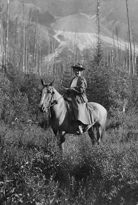
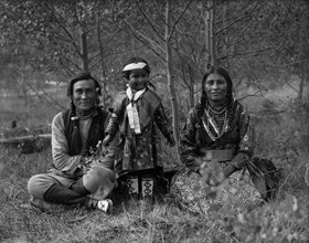
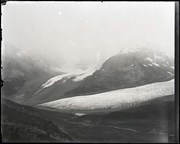
- Negatives pertain mainly to flora and explorations. Many mountain and plant views are unidentified. Includes two photographs of the Sampson Beaver family
- Date Range
- 1905-[ca.1906]
- Reference Code
- V527 / NG - 1 to 181
- Description Level
- 5 / File
- GMD
- Photograph
- Negative
6 images
- Part Of
- Mary Schaffer fonds
- Description Level
- 5 / File
- Fonds Number
- M79 / V527
- Series
- II.C. Photographs: negatives
- Sous-Fonds
- V527
- Accession Number
- 275, 2764, 5248
- Reference Code
- V527 / NG - 1 to 181
- GMD
- Photograph
- Negative
- Date Range
- 1905-[ca.1906]
- Physical Description
- 181 photographs : negatives; glass
- Scope & Content
- Negatives pertain mainly to flora and explorations. Many mountain and plant views are unidentified. Includes two photographs of the Sampson Beaver family
- Access Restrictions
- Access by appointment only
- Finding Aid
- Item list available. Some reference prints are available.
- Title Source
- Title based on contents of file
- Content Details
- This material is presented as originally created, it contains outdated cultural descriptions and potentially offensive content. Materials in historical collections reflect the attitudes, ideas, and norms of the era and culture in which they were created or collected. Offensive or harmful terms are retained for historical accuracy or to document the issues and social context of a specific time and the attitudes and opinions of the people who created the material. LIST OF NEGATIVES (V527/NG) :
- 1 [Plant] / Mary Schaffer. -- 1906
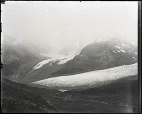
- 2 Mt. Forbes and Lyall Ice Fields from junction of Bear Creek and Saskatchewan River / Mary Schaffer. -- 1906
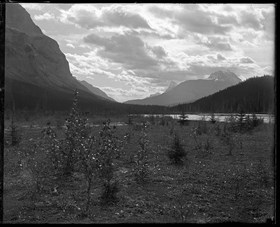
- 3, 5-7, 9 [Unidentified mountain scene] / Mary Schaffer. -- 1906
- 4 Athabasca and Dome Glaciers / Mary Schaffer. -- 1906
- 8 The Beacon in Cataract Valley / Mary Schaffer. -- 1906
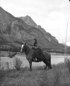
- 10 [Mary Schaffer on horse]. -- 1906
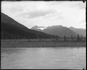
- 11 Looking south from near Graveyard Flats on the North Saskatchewan River / Mary Schaffer. -- 1906
- 12 [Cones] / Mary Schaffer. -- 1906
- 13-16 [Unidentified mountain scene] / Mary Schaffer. -- 1906
- 17 [Mary Schaffer on horse]. -- 1906?
- 18 Mt. Saskatchewan from overflow lakes on the North Saskatchewan near Rampart Creek / Mary Schaffer. -- 1906?
- 19 Look south on the North Fork of the Saskatchewan River / Mary Schaffer. -- 1906
- 20-22 [Unidentified mountain scene] / Mary Schaffer. -- 1906?
- 23 Billy Warren, right, and [Joe?] Barker, left in camp with fish / Mary Schaffer. -- 1906?
- 24,25 [Unidentified mountain scene] / Mary Schaffer. -- 1906?
- 26,27 Coral Canyon, Cline River area / Mary Schaffer. -- 1906?
- 28 [Plant] / Mary Schaffer. -- 1906
- 29 [Unidentified mountain scene] / Mary Schaffer. -- 1906
- 30 [Plant] / Mary Schaffer. -- 1906
- 31-47 [Plant] / Mary Schaffer
- 48 Primula, Banff / Mary Schaffer. -- 6/10/05
- 49 Amelachier florida, Bankhead / Mary Schaffer. -- 6/19/05
- 50-53 [Plant]
- 54 Pinus albicaulis, Tunnel / Mary Schaffer. -- 6/5/05
- 55 Kruhsea Tilingiana, Glacier / Mary Schaffer. -- 5/26/05
- 56 Pentstemon conferlus, Banff / Mary Schaffer. -- 6/23/05
- 57 Draba, Sulphur Mtn / Mary Schaffer -- 6/22/05
- 58 Sheperdia canadensis, Banff / Mary Schaffer. -- 5/31/05
- 59 Berberis Aquisulium Field / Mary Schaffer. -- 6/7/05
- 60 Colliusia bicolor, Lake Louise / Mary Schaffer. -- 6/11/05
- 61 Primula, Banff / Mary Schaffer. -- 6/8/05
- 62 Vagnera stellata, Banff / Mary Schaffer. -- 6/9/05
- 63-65 [Plant] / Mary Schaffer
- 66 Plant - Dodecatheon / Mary Schaffer
- 67 Plant - Picaea alba - Tunnel Mtn / Mary Schaffer. -- 6/9/05
- 68 [Statue, Greek?] / Mary Schaffer
- 69 [Wall carving] / Mary Schaffer
- 70 [Head of statute] / Mary Schaffer
- 71 [Statue] / Mary Schaffer
- 72 [Sculpture of man] / Mary Schaffer
- 73 [Sculpture - boy & goose] / Mary Schaffer
- 74,75 [Sculpture] / Mary Schaffer
- 76 [Head of statue] / Mary Schaffer
- 77 Ledium palustre, L. latifolium : [plant] / Mary Schaffer
- 78-82 [Plant] / Mary Schaffer
- 83 Pachystima macrophyllium (Bear Cr.) : [plant] / Mary Schaffer. -- 5/25/05
- 84-86 [Plant] / Mary Schaffer
- 87 Draba aurea; Stoney Squaw : [plant] / Mary Schaffer. -- 6/24/05
- 88-92 [Plant] / Mary Schaffer
- 93 Vacinium microphyllum : [plant] / Mary Schaffer
- 94 Observation Peak & Bow Pass from North? / Mary Schaffer
- 95 [Camp scene, Mary Schaffer at left]
- 96 [Teepee frame] / Mary Schaffer
- 97 [Unidentified mountains] / Mary Schaffer
- 98 Mt. Saskatchewan / Mary Schaffer
- 99,100 [Unidentified mountain scene] / Mary Schaffer
- 101,102 [Unidentified mountains and lake] / Mary Schaffer
- 103 [Unidentified valley and mountains] / Mary Schaffer
- 104 [Train in the mountains] / Mary Schaffer
- 105,106 [Unidentified mountain scene] / Mary Schaffer
- 107 [Plant] / Mary Schaffer
- 108 [Mountain scene] / Mary Schaffer
- 109 [Saskatchewan River Valley?]. -- [1906]
- 110,111 [Saskatchewan Glacier?]. -- [1906]
- 112 [Mary Schaffer on her horse Nibs]
- 113 [Teepee at Maligne Lake?]
- 114 [Boat on shore of Maligne Lake]
- 115,116 [Joe Barker?]
- 117,118 [Camp at base of unidentified mountains]
- 119 [Camp on shore of unidentified lake]
- 120 [Man with pole at edge of lake]
- 121 [Man in door of shelter made with trees]
- 122 [Teepee at foot of unidentified mountain]
- 123 [Camp in burnt timber]
- 124 [Sampson Beaver family, 1906]
- 125 [Sampson Beaver family]
- 126 baby on Kootenai Plains : [Frances Louise Beaver]. -- [1906]
- 127-132 [Unidentified mountains]
- 133 [Unidentified lake]
- 134 [Unidentified river]
- 135,136 [Unidentified river and mountains]
- 137,138 [Unidentified lake and mountains]
- 139 [Map of Canadian Rockies]
- 140 [Duck]
- 141-155 [Plants - identified and dated]
- 156-159 [Plants - identified]
- 160-180 [Plants - unidentified]
- 181 [Cones]
- Processing Status
- Processed
Images
This material is presented as originally created; it may contain outdated cultural descriptions and
potentially offensive content.
Read more.
Wartime work for the National Film Board of Canada
https://archives.whyte.org/en/permalink/descriptions9421
- Part Of
- Ron Duke fonds
- Scope & Content
- Sub-series pertains to 131 black & white negatives of various military training operations, mostly around Ottawa [?] taken by Ron Duke while working for the National Film Board during World War II. Includes landscapes, airplanes, truck convoys, military bases and camps, parades, and group shots in …
- Date Range
- [ca. 1940-1945]
- Reference Code
- V180 / I / B / iii / NA - 01 to 19
- Description Level
- 5 / File
- GMD
- Film
- Negative
- Part Of
- Ron Duke fonds
- Description Level
- 5 / File
- Fonds Number
- M16 / V180
- Series
- I. Early material
- Sous-Fonds
- V180
- Accession Number
- 5772
- Reference Code
- V180 / I / B / iii / NA - 01 to 19
- Date Range
- [ca. 1940-1945]
- Physical Description
- 131 photographs : b&w nitrate negatives ; 10 x 12.5 cm or smaller
- Scope & Content
- Sub-series pertains to 131 black & white negatives of various military training operations, mostly around Ottawa [?] taken by Ron Duke while working for the National Film Board during World War II. Includes landscapes, airplanes, truck convoys, military bases and camps, parades, and group shots in various settings - includes multiple negatives per envelope. [1] - [Group of people holding a “Welcome West” sign] [2] - [Military gun manufacture] [3] - [Military plane in flight] [4] - [Military trucks on road – one rolled over in ditch] [5] - [Truck convoy] [6] - [Forest training camp] [7] - [Military plane in flight – dropping bombs?] [8] - [Portraits of men in safety equipment] [9] - [Machinery] [10] - [Men at work in workshops] [11] - [Skiing?] [12] - [Aerial view of forest] [13] - [Deep snow on steps and car] [14] - [People looking out train windows at station] [15] - [Collection of buildings – military base?] [16] - [Group shots of people – mostly men in military uniforms] [17] - [People on military base] [18] - [Military parade] [19] - [Prairie landscape]
- Subject Access
- Airplanes
- Automobiles
- Buildings
- Camps
- Military
- War
- Winter
- World War II
- WWII
- Geographic Access
- Ontario
- Canada
- Language
- English
- Title Source
- Title based on sub-series
- Processing Status
- Processed
This material is presented as originally created; it may contain outdated cultural descriptions and
potentially offensive content.
Read more.
Personal photographs - friends and family
https://archives.whyte.org/en/permalink/descriptions9422
- Part Of
- Ron Duke fonds
- Date Range
- [ca. 1940-1944]
- Reference Code
- V180 / I / B / i / NA - 01 to 12
- Description Level
- 5 / File
- GMD
- Film
- Negative
- Part Of
- Ron Duke fonds
- Description Level
- 5 / File
- Fonds Number
- M16 / V180
- Series
- I. Early material
- Sous-Fonds
- V180
- Accession Number
- 5772
- Reference Code
- V180 / I / B / i / NA - 01 to 12
- Date Range
- [ca. 1940-1944]
- Physical Description
- 43 photographs : b&w nitrate negatives ; 11.3 x 8 cm or smaller
- Subject Access
- Activities
- Children
- Family and personal life
- Photography
- Portrait
- Geographic Access
- Ottawa
- Ontario
- Manitoba
- Canada
- Language
- NA
- Title Source
- Title based on contents of sub-series
- Processing Status
- Processed
This material is presented as originally created; it may contain outdated cultural descriptions and
potentially offensive content.
Read more.
Misc. negatives
https://archives.whyte.org/en/permalink/descriptions9423
- Part Of
- Ron Duke fonds
- Scope & Content
- Sub-series pertains to 9 black & white negatives of train tracks in mountains and posed plates with food in personal homes. [1] - [Mountain scenes with train tracks] [2] - [Plates of food in domestic settings]
- Date Range
- [ca. 1940-1945]
- Reference Code
- V180 / I / B / ii / NA - 01 to 02
- Description Level
- 5 / File
- GMD
- Film
- Negative
- Part Of
- Ron Duke fonds
- Description Level
- 5 / File
- Fonds Number
- M16 / V180
- Series
- I. Early material
- Sous-Fonds
- V1180
- Accession Number
- 5772
- Reference Code
- V180 / I / B / ii / NA - 01 to 02
- Date Range
- [ca. 1940-1945]
- Physical Description
- 9 photographs : b&w nitrate negatives ; 11.3 x 8 cm or smaller
- Scope & Content
- Sub-series pertains to 9 black & white negatives of train tracks in mountains and posed plates with food in personal homes. [1] - [Mountain scenes with train tracks] [2] - [Plates of food in domestic settings]
- Geographic Access
- Alberta
- Language
- NA
- Title Source
- Title based on sub-series
- Processing Status
- Processed
This material is presented as originally created; it may contain outdated cultural descriptions and
potentially offensive content.
Read more.
(part of Cascade River)
https://archives.whyte.org/en/permalink/catalogue24478
- Medium
- Library - Maps and blueprints (unannotated; published)
- Map
- Published Date
- July 3rd, 1907
- Publisher
- Department of the Interior
- Call Number
- C9-7.27
- Publisher
- Department of the Interior
- Published Date
- July 3rd, 1907
- Physical Description
- 1 map : black and white
- Scale
- 40 chains: 1 "
- Accession Number
- SG7500
- Call Number
- C9-7.27
- Collection
- Archives Library
This material is presented as originally created; it may contain outdated cultural descriptions and
potentially offensive content.
Read more.
(Part of Cascade River)
https://archives.whyte.org/en/permalink/catalogue24479
- Medium
- Library - Maps and blueprints (unannotated; published)
- Map
- Published Date
- May 6th, 1907
- Publisher
- Depatrment of the Interior
- Call Number
- C9-7.27
- Publisher
- Depatrment of the Interior
- Published Date
- May 6th, 1907
- Physical Description
- 1 map : black and white
- Scale
- 40 chains 1 "
- Accession Number
- SG7500
- Call Number
- C9-7.27
- Collection
- Archives Library
This material is presented as originally created; it may contain outdated cultural descriptions and
potentially offensive content.
Read more.
(part of Cascade River)
https://archives.whyte.org/en/permalink/catalogue24482
- Medium
- Library - Maps and blueprints (unannotated; published)
- Map
- Published Date
- May 6, 1907
- Publisher
- Department of the Interior
- Call Number
- C9-7.28
- Publisher
- Department of the Interior
- Published Date
- May 6, 1907
- Physical Description
- 1 map : black and white
- Scale
- 40 chains: 1 inch
- Accession Number
- SG7500
- Call Number
- C9-7.28
- Collection
- Archives Library
This material is presented as originally created; it may contain outdated cultural descriptions and
potentially offensive content.
Read more.
(Lake Louise Forest Park)
https://archives.whyte.org/en/permalink/catalogue24484
- Medium
- Library - Maps and blueprints (unannotated; published)
- Map
- Published Date
- February 10, 1896
- Publisher
- Department of the Interior
- Call Number
- C9-7.28
- Publisher
- Department of the Interior
- Published Date
- February 10, 1896
- Physical Description
- 1 map : black and white
- Scale
- 40 chains: 1 inch
- Notes
- xerox copy
- Accession Number
- SG7500
- Call Number
- C9-7.28
- Collection
- Archives Library
This material is presented as originally created; it may contain outdated cultural descriptions and
potentially offensive content.
Read more.
(edge of Lake Louise Forest Park)
https://archives.whyte.org/en/permalink/catalogue24485
- Medium
- Library - Maps and blueprints (unannotated; published)
- Map
- Published Date
- January 7th, 1896
- Publisher
- Department of the Interior
- Call Number
- C9-7.29
- Publisher
- Department of the Interior
- Published Date
- January 7th, 1896
- Physical Description
- 1 map : black and white
- Scale
- 40 chains: 1 inch
- Notes
- xerox copy
- Accession Number
- SG7500
- Call Number
- C9-7.29
- Collection
- Archives Library
This material is presented as originally created; it may contain outdated cultural descriptions and
potentially offensive content.
Read more.
Cart trail from Calgary to Edmonton
https://archives.whyte.org/en/permalink/catalogue24486
- Medium
- Library - Maps and blueprints (unannotated; published)
- Map
- Published Date
- 1890
- Publisher
- Dept. of the Interior
- Call Number
- C9-7.31
- Publisher
- Dept. of the Interior
- Published Date
- 1890
- Scale
- 1 mile: 2 inches
- Notes
- photostatic copy from Public Archives
- Accession Number
- 675
- Call Number
- C9-7.31
- Collection
- Archives Library
This material is presented as originally created; it may contain outdated cultural descriptions and
potentially offensive content.
Read more.
Morleyville Trail and Cart Trail from Calgary to Edmonton
https://archives.whyte.org/en/permalink/catalogue24488
- Medium
- Library - Maps and blueprints (unannotated; published)
- Map
- Published Date
- 1890
- Publisher
- Dept. of the Interior
- Call Number
- C9-7.32
- Publisher
- Dept. of the Interior
- Published Date
- 1890
- Scale
- 1 mile: 2 inches
- Notes
- photostatic copy from Public Archives
- Accession Number
- 675
- Call Number
- C9-7.32
- Collection
- Archives Library
This material is presented as originally created; it may contain outdated cultural descriptions and
potentially offensive content.
Read more.
Morleyville Traill; Calgary-Edmonton Rwy.
https://archives.whyte.org/en/permalink/catalogue24489
- Medium
- Library - Maps and blueprints (unannotated; published)
- Map
- Published Date
- 1893
- Publisher
- Dept. of the Interior
- Call Number
- C9-7.33
- Publisher
- Dept. of the Interior
- Published Date
- 1893
- Scale
- 1 mile: 2 inches
- Notes
- photostatic opy from Public Archives
- Accession Number
- 675
- Call Number
- C9-7.33
- Collection
- Archives Library
This material is presented as originally created; it may contain outdated cultural descriptions and
potentially offensive content.
Read more.
Range 1, West of Fifth Meridian, Trail from Calgary to Edmonton (Railway)
https://archives.whyte.org/en/permalink/catalogue24491
- Medium
- Library - Maps and blueprints (unannotated; published)
- Map
- Published Date
- 1896
- Publisher
- Dept. of the Interior
- Call Number
- C9-7.34(a)
- Publisher
- Dept. of the Interior
- Published Date
- 1896
- Scale
- 1 mile: 2 inches
- Subjects
- Township #34
- Notes
- photostatic copy from Public Archives
- Accession Number
- 675
- Call Number
- C9-7.34(a)
- Collection
- Archives Library
This material is presented as originally created; it may contain outdated cultural descriptions and
potentially offensive content.
Read more.
Trail from Calgary to Edmonton and Railway
https://archives.whyte.org/en/permalink/catalogue24493
- Medium
- Library - Maps and blueprints (unannotated; published)
- Map
- Published Date
- 1897
- Publisher
- Dept. of the Interior
- Call Number
- C9-7.35
- Publisher
- Dept. of the Interior
- Published Date
- 1897
- Scale
- 1 mile: 2 inches
- Notes
- Photostatic oopy from Public Archives
- Accession Number
- 675
- Call Number
- C9-7.35
- Collection
- Archives Library
This material is presented as originally created; it may contain outdated cultural descriptions and
potentially offensive content.
Read more.
[British Columbia, Highways] Alberta Motor Association
https://archives.whyte.org/en/permalink/catalogue24512
- Medium
- Library - Maps and blueprints (unannotated; published)
- Map
- Published Date
- 1941
- Call Number
- C10-1.1
- Published Date
- 1941
- Scale
- 1 inch-40 miles
- Subjects
- British Columbia
- Highways
- Notes
- Tourist information for 1941 on reverse side of map
- Accession Number
- 400
- Call Number
- C10-1.1
- Collection
- Archives Library
This material is presented as originally created; it may contain outdated cultural descriptions and
potentially offensive content.
Read more.
Map of the Kootenay District - A mining recording divisions map
https://archives.whyte.org/en/permalink/catalogue24533
- Medium
- Library - Maps and blueprints (unannotated; published)
- Map
- Published Date
- 1897
- Publisher
- Dept. of Lands and Works, Victoria
- Call Number
- C10-6.3
- Publisher
- Dept. of Lands and Works, Victoria
- Published Date
- 1897
- Scale
- Scale: 12 miles - 1 inch
- Subjects
- Central British Columbia
- Notes
- Photostatic copy from Public Archives
- Accession Number
- 675
- Call Number
- C10-6.3
- Collection
- Archives Library
This material is presented as originally created; it may contain outdated cultural descriptions and
potentially offensive content.
Read more.
Central British Columbia
https://archives.whyte.org/en/permalink/catalogue24534
- Medium
- Library - Maps and blueprints (unannotated; published)
- Map
- Published Date
- 1940
- Publisher
- Dept. of Lands, B.C.
- Call Number
- C10-6.5
- Publisher
- Dept. of Lands, B.C.
- Published Date
- 1940
- Scale
- Scale: 1:1,000,000
- Subjects
- Central British Columbia
- Accession Number
- 540
- 3349?
- Call Number
- C10-6.5
- Collection
- Archives Library
This material is presented as originally created; it may contain outdated cultural descriptions and
potentially offensive content.
Read more.
[Canada] Relief map
https://archives.whyte.org/en/permalink/catalogue24548
- Medium
- Library - Maps and blueprints (unannotated; published)
- Map
- Published Date
- 1904
- Publisher
- Dept. of the Interior
- Call Number
- C11-2.1
- Publisher
- Dept. of the Interior
- Published Date
- 1904
- Scale
- Scale: 100 miles to 1 inch
- Relief: Altitude tints
- Subjects
- Canada
- Accession Number
- 400
- Call Number
- C11-2.1
- Collection
- Archives Library
This material is presented as originally created; it may contain outdated cultural descriptions and
potentially offensive content.
Read more.
Dominion of Canada and Newfoundland
https://archives.whyte.org/en/permalink/catalogue24550
- Medium
- Library - Maps and blueprints (unannotated; published)
- Map
- Published Date
- 1898
- Publisher
- Rand McNally and Co. Republished by the Royal Canadian Geographical Society in 1967 in recognition of Canada's Centennial
- Call Number
- C11-2.3
- Publisher
- Rand McNally and Co. Republished by the Royal Canadian Geographical Society in 1967 in recognition of Canada's Centennial
- Published Date
- 1898
- Scale
- Scale: 180 miles - 1 inch
- Subjects
- Canada
- Notes
- Duplicate in map room/Accn: 400)
- Accession Number
- 400
- 673
- Call Number
- C11-2.3
- Collection
- Archives Library
This material is presented as originally created; it may contain outdated cultural descriptions and
potentially offensive content.
Read more.
[Canada] National Transcontinental Railway route
https://archives.whyte.org/en/permalink/catalogue24553
- Medium
- Library - Maps and blueprints (unannotated; published)
- Map
- Published Date
- 1901
- Publisher
- Dept. of the Interior
- Call Number
- C11-3.3
- Publisher
- Dept. of the Interior
- Published Date
- 1901
- Scale
- Scale: 100 miles to 1 inch
- Subjects
- Canada
- Railway routes
- Accession Number
- 400
- Call Number
- C11-3.3
- Collection
- Archives Library
This material is presented as originally created; it may contain outdated cultural descriptions and
potentially offensive content.
Read more.

