Narrow Results By
- Luxton family fonds 109
- George McLean fonds 37
- Nicholas Morant fonds 33
- Kidney family fonds 32
- Archives General File Collection 27
- Joe Kootenay fonds 24
- Trail Riders of the Canadian Rockies fonds 18
- Eliza Hunter fonds 14
- Peter and Catharine Whyte fonds 13
- Lawrence Grassi fonds 10
- Alpine Club of Canada fonds 9
- Bruno Engler fonds 9
Extended family records
https://archives.whyte.org/en/permalink/descriptions22344
- Part Of
- Luxton family fonds
- Scope & Content
- Records in this series consist of three sub-series: C.1. William Luxton family papers and photographs; C.2. McDougall and Ross families papers, correspondence, and photographs; C.3. Other extended family records. Sub-series C.1. consists of four sub-sub-series: William Luxton; Sarah Luxton; Geor…
- Date Range
- 1893-1970
- Reference Code
- LUX / III / C
- Description Level
- 3 / Series
- GMD
- Textual record
- Private record
- Photograph
- Photograph print
- Part Of
- Luxton family fonds
- Description Level
- 3 / Series
- Fonds Number
- LUX
- Series
- III.C. Extended Family
- Sous-Fonds
- III. Luxton Family sous-fonds
- Accession Number
- LUX
- Reference Code
- LUX / III / C
- Date Range
- 1893-1970
- Physical Description
- 0.28 m textual records ; ca.147 photographs : b&w prints; 15 x 21 cm or smaller
- Scope & Content
- Records in this series consist of three sub-series: C.1. William Luxton family papers and photographs; C.2. McDougall and Ross families papers, correspondence, and photographs; C.3. Other extended family records. Sub-series C.1. consists of four sub-sub-series: William Luxton; Sarah Luxton; George Luxton; Louis Luxton. Sub-series C.2. consists of two sub-sub-series: McDougall family; Ross family.
- Language
- English
- Category
- Family and personal life
- Communications
- Title Source
- Title based on contents of series
- Processing Status
- Processed
This material is presented as originally created; it may contain outdated cultural descriptions and
potentially offensive content.
Read more.
Bennett Trips 1931 to 1936
https://archives.whyte.org/en/permalink/descriptions23415
- Part Of
- Bert Riggall fonds
- Scope & Content
- File consists of 22 b&w photographs, some captioned. Photographs pertain to the Bennett trips guided and outfitted by Riggall of 1931, 1933, 1934, 1935, and 1936. The photographs document packtrains, camp life, hiking, Herbst glacier, and fishing. Locations of photographs include: Wall Lake, Mount …
- Date Range
- 1931
- 1933-1936
- Reference Code
- V26 / II / A4 / PA - 130 to 152
- Description Level
- 5 / File
- GMD
- Photograph
- Photograph print
- Part Of
- Bert Riggall fonds
- Description Level
- 5 / File
- Fonds Number
- M376 / V26
- Series
- II.Business and Financial: Client Papers and Photographs
- Sous-Fonds
- V26
- Accession Number
- 7201
- Reference Code
- V26 / II / A4 / PA - 130 to 152
- Date Range
- 1931
- 1933-1936
- Physical Description
- Photographs: 22 b&w prints
- Scope & Content
- File consists of 22 b&w photographs, some captioned. Photographs pertain to the Bennett trips guided and outfitted by Riggall of 1931, 1933, 1934, 1935, and 1936. The photographs document packtrains, camp life, hiking, Herbst glacier, and fishing. Locations of photographs include: Wall Lake, Mount Festubert, Great Divide at South Kootenay Pass.
- Subject Access
- Guiding, Camping, Packtrains
- Hiking
- Camping
- Recreation
- Sports
- Fishing
- Geographic Access
- Canada
- Canadian Rocky Mountains
- British Columbia
- Kootenay National Park
- Great Divide
- Language
- N/A
- Title Source
- Title based on contents of file
- Processing Status
- Processed
This material is presented as originally created; it may contain outdated cultural descriptions and
potentially offensive content.
Read more.
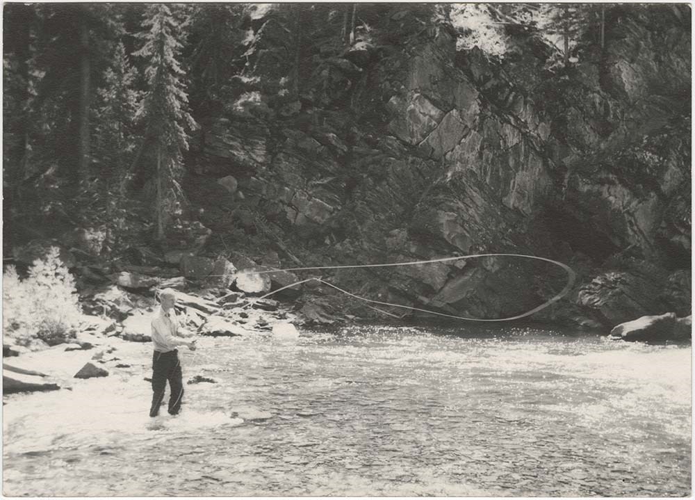
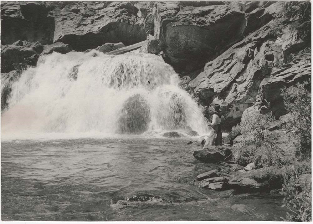
Bovey trips 1939 to 1941
https://archives.whyte.org/en/permalink/descriptions23425
- Part Of
- Bert Riggall fonds
- Scope & Content
- File consists of 26 b&w photographs, some captioned. Photographs pertain to the Bovey trips guided and outfitted by Riggall of 1939, 1940, and 1941. The photographs document the Bovey party in camp covered with snow, fishing, fishing, and making movies. Locations of photographs include Twin Lakes, …
- Date Range
- 1939, 1940, 1941
- Reference Code
- V26 / II / A4 / PA - 353 to 378
- Description Level
- 5 / File
- GMD
- Photograph
- Photograph print
4 images
- Part Of
- Bert Riggall fonds
- Description Level
- 5 / File
- Fonds Number
- M376 / V26
- Series
- II.Business and Financial: Client Papers and Photographs
- Sous-Fonds
- V26
- Reference Code
- V26 / II / A4 / PA - 353 to 378
- Date Range
- 1939, 1940, 1941
- Physical Description
- Photographs: 26 prints, b&w
- Scope & Content
- File consists of 26 b&w photographs, some captioned. Photographs pertain to the Bovey trips guided and outfitted by Riggall of 1939, 1940, and 1941. The photographs document the Bovey party in camp covered with snow, fishing, fishing, and making movies. Locations of photographs include Twin Lakes, Profanity Creek, and Larch Creek.
- Subject Access
- Guiding, Fishing, Camp
- Title Source
- Title based on contents of file
- Processing Status
- Processed
Images
This material is presented as originally created; it may contain outdated cultural descriptions and
potentially offensive content.
Read more.
Faegre and Dorsey Trips 1935 to 1945
https://archives.whyte.org/en/permalink/descriptions23467
- Part Of
- Bert Riggall fonds
- Scope & Content
- File consists of 32 b&w photographs, some captioned. Photographs pertain to the Faegre and Dorsey Trips 1935 to 1945. The photographs document camp life, hiking, climbing, pack trains, and fishing. Locations of photographs include Boundary Meadow, Herbst Glacier, Kishinena, Wall Lake, and the Oldma…
- Date Range
- 1935, 1939, 1942, 1945
- Reference Code
- V26 / III / A15 / PA - 1 to 32
- Description Level
- 5 / File
- GMD
- Photograph
- Photograph print
2 images
- Part Of
- Bert Riggall fonds
- Description Level
- 5 / File
- Fonds Number
- M376 / V26
- Series
- III. Professional Photography: Guiding and Hunting Trips
- Sous-Fonds
- V26
- Reference Code
- V26 / III / A15 / PA - 1 to 32
- Date Range
- 1935, 1939, 1942, 1945
- Physical Description
- Photographs: 32 prints, b&w
- Scope & Content
- File consists of 32 b&w photographs, some captioned. Photographs pertain to the Faegre and Dorsey Trips 1935 to 1945. The photographs document camp life, hiking, climbing, pack trains, and fishing. Locations of photographs include Boundary Meadow, Herbst Glacier, Kishinena, Wall Lake, and the Oldman River.
- Subject Access
- Hunting, Guiding, Climbing
- Title Source
- Title based on contents of file
- Processing Status
- Processed
Images

This material is presented as originally created; it may contain outdated cultural descriptions and
potentially offensive content.
Read more.
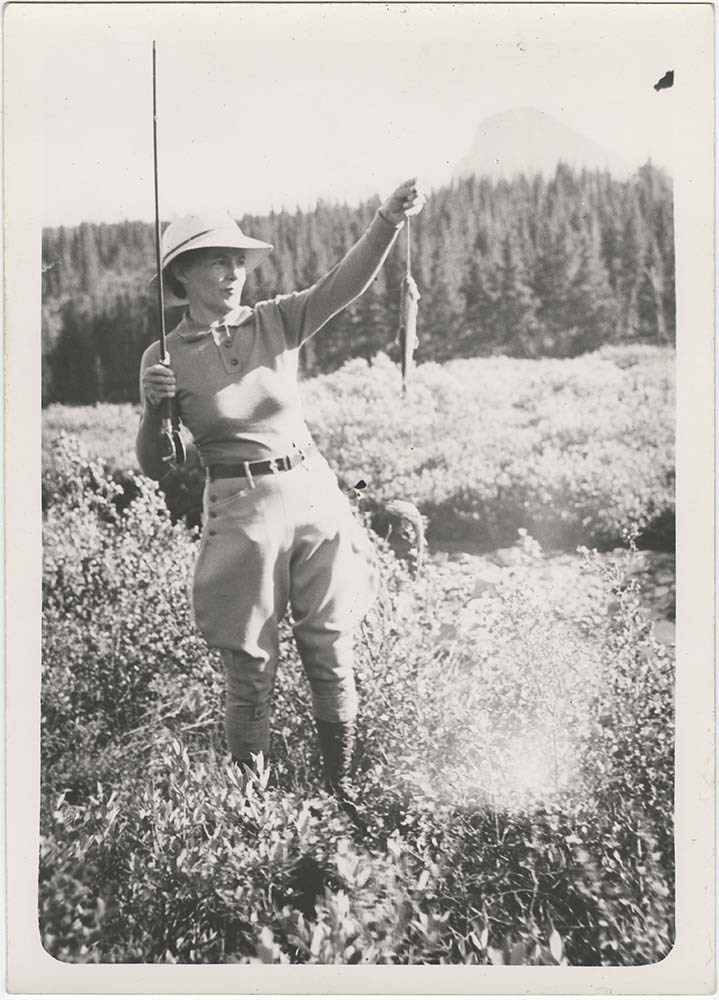
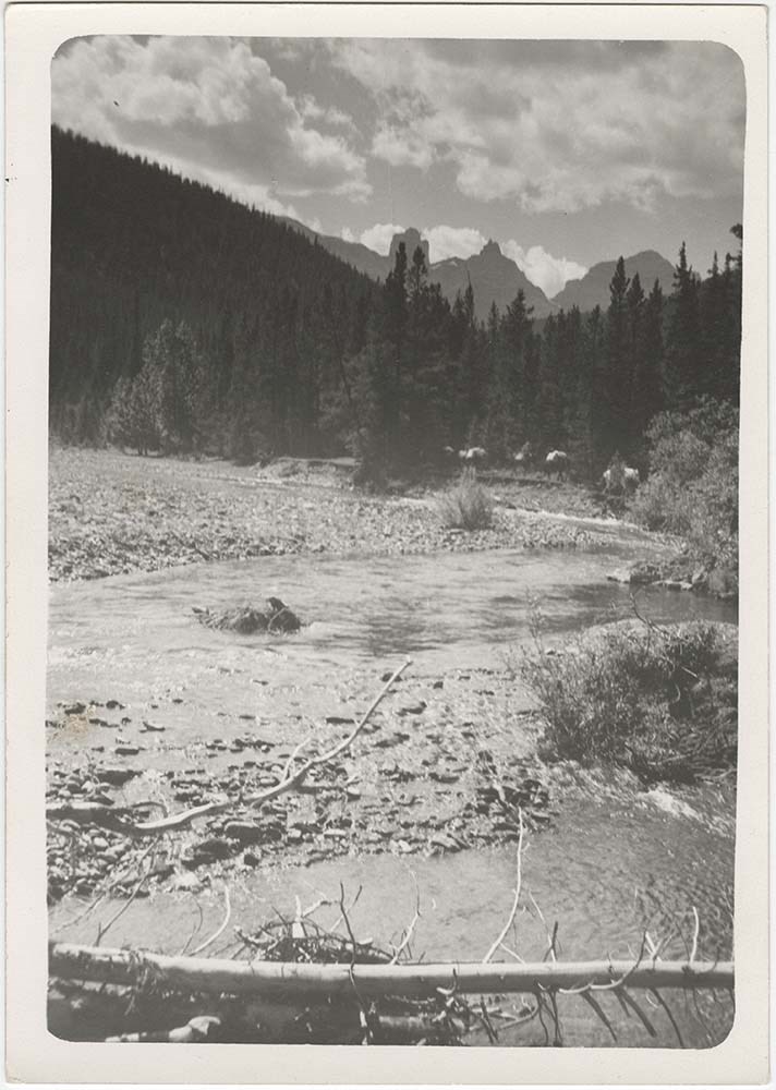
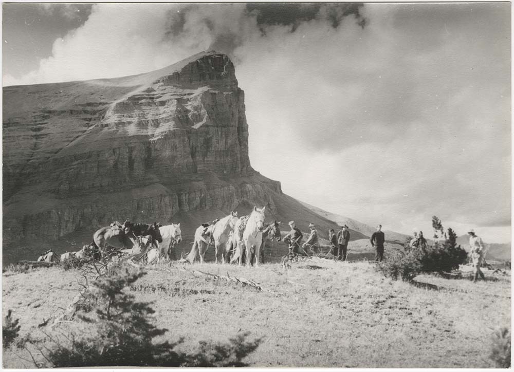
Various Client Trips
https://archives.whyte.org/en/permalink/descriptions23468
- Part Of
- Bert Riggall fonds
- Scope & Content
- File consists of 30 b&w photographs, some captioned. Photographs pertain to the following client trips: Mrs. Vincent's Trip, 1936; Brandeis Trip, 1936; Janey Harper, 1936; Lockwood, 1937. The photographs document camp life, hiking, climbing, pack trains, and marmot hunting. Locations of photographs…
- Date Range
- 1936, 1937
- Reference Code
- V26 / III / A16 / PA - 1 to V26 / III / A19 / PA - 19
- Description Level
- 5 / File
- GMD
- Photograph
- Photograph print
3 images
- Part Of
- Bert Riggall fonds
- Description Level
- 5 / File
- Fonds Number
- M376 / V26
- Series
- III. Professional Photography: Guiding and Hunting Trips
- Sous-Fonds
- V26
- Reference Code
- V26 / III / A16 / PA - 1 to V26 / III / A19 / PA - 19
- Date Range
- 1936, 1937
- Physical Description
- Photographs: 30 prints, b&w
- Scope & Content
- File consists of 30 b&w photographs, some captioned. Photographs pertain to the following client trips: Mrs. Vincent's Trip, 1936; Brandeis Trip, 1936; Janey Harper, 1936; Lockwood, 1937. The photographs document camp life, hiking, climbing, pack trains, and marmot hunting. Locations of photographs include Elysian Lake, Oyster Creek, Twin Lakes, Kishinena Creek, Beehive mountain, Profanity Range, and Slacker Creek.
- Subject Access
- Hunting, Guiding, Climbing
- Title Source
- Title based on contents of file
- Content Details
- V26 / III / A16 / PA - 1 to 2 Pertain to Mrs. Vincent's trip, 1936.
- V26 / III / A17 / PA - 1 to 3 Pertain to the Brandeis trip, 1936.
- V26 / III / A18 / PA - 1 to 6 Pertain to Janey Harper's trip, 1936.
- V26 / III / A19 / PA - 1 to 19 Pertain to the Lockwood trip, 1937.
- Riggall's Grandson John Russell has captioned an image as follows:
- V26 / III / A18 / PA - 4 Upper Twin Lake
- Processing Status
- Processed
Images

This material is presented as originally created; it may contain outdated cultural descriptions and
potentially offensive content.
Read more.
Walcott Trip, 1938
https://archives.whyte.org/en/permalink/descriptions23469
- Part Of
- Bert Riggall fonds
- Scope & Content
- File consists of 24 b&w photographs, some captioned. Photographs pertain to the Walcott family trip, 1938. The photographs document camp life, hiking, climbing, pack trains, horses and landscapes. Locations of photographs include Panorama Peak, Savannah Creek, Beehive Mountain, the "Gap" district, …
- Date Range
- 1938
- Reference Code
- V26 / III / A20 / PA - 1 to 24
- Description Level
- 5 / File
- GMD
- Photograph
- Photograph print
1 image
- Part Of
- Bert Riggall fonds
- Description Level
- 5 / File
- Fonds Number
- M376 / V26
- Series
- III. Professional Photography: Guiding and Hunting Trips
- Sous-Fonds
- V26
- Reference Code
- V26 / III / A20 / PA - 1 to 24
- Date Range
- 1938
- Physical Description
- Photographs: 24 prints, b&w
- Scope & Content
- File consists of 24 b&w photographs, some captioned. Photographs pertain to the Walcott family trip, 1938. The photographs document camp life, hiking, climbing, pack trains, horses and landscapes. Locations of photographs include Panorama Peak, Savannah Creek, Beehive Mountain, the "Gap" district, Oldman River, and Racehorse Creek.
- Subject Access
- Guiding, Climbing, Hiking
- Title Source
- Title based on contents of file
- Processing Status
- Processed
Images
This material is presented as originally created; it may contain outdated cultural descriptions and
potentially offensive content.
Read more.
[Mount Peck 82 J/3 East - B.C.]
https://archives.whyte.org/en/permalink/catalogue23762
- Medium
- Library - Maps and blueprints (unannotated; published)
- Map
- Published Date
- 1966
- Publisher
- Dept. of Mines and Technical Surveys
- Call Number
- NTS
- 82J/3E
- Publisher
- Dept. of Mines and Technical Surveys
- Published Date
- 1966
- Physical Description
- Colour
- Scale
- Scale: 1:50,000
- Relief: Contour interval 100'
- Subjects
- Mount Peck 82 J/3 East - B.C.
- Notes
- National Topographic System
- Accession Number
- 718
- Call Number
- NTS
- 82J/3E
- Collection
- Archives Library
This material is presented as originally created; it may contain outdated cultural descriptions and
potentially offensive content.
Read more.
[Mount Peck 82 J/3 West - B.C.]
https://archives.whyte.org/en/permalink/catalogue23763
- Medium
- Library - Maps and blueprints (unannotated; published)
- Map
- Published Date
- 1966
- Publisher
- Dept. of Mines and Technical Surveys
- Call Number
- NTS
- 82J/3W
- Publisher
- Dept. of Mines and Technical Surveys
- Published Date
- 1966
- Physical Description
- Colour
- Scale
- Scale: 1:50,000
- Relief: Contour interval 100'
- Subjects
- Mount Peck 82 J/3 West - B.C.
- Notes
- National Topographic System
- Accession Number
- 718
- Call Number
- NTS
- 82J/3W
- Collection
- Archives Library
This material is presented as originally created; it may contain outdated cultural descriptions and
potentially offensive content.
Read more.
[Mount Queen Bess 92 N/7 East - B.C.]
https://archives.whyte.org/en/permalink/catalogue23764
- Medium
- Library - Maps and blueprints (unannotated; published)
- Map
- Published Date
- 1968
- Publisher
- Department of Energy, Mines and Resources
- Call Number
- NTS
- 92N/7E
- Publisher
- Department of Energy, Mines and Resources
- Published Date
- 1968
- Physical Description
- Colour
- Scale
- Scale: 1:50,000
- Relief: Contour Interval 100 ft.
- Subjects
- Mount Queen Bess 92 N/7 East - B.C.
- Notes
- National Topographic System
- Accession Number
- 3000
- Call Number
- NTS
- 92N/7E
- Collection
- Archives Library
This material is presented as originally created; it may contain outdated cultural descriptions and
potentially offensive content.
Read more.
[Mount Queen Bess 92 N/7 West - B.C.]
https://archives.whyte.org/en/permalink/catalogue23765
- Medium
- Library - Maps and blueprints (unannotated; published)
- Map
- Published Date
- 1968
- Publisher
- Dept. of Energy, Mines and Resources
- Call Number
- NTS
- 92N/7W
- Publisher
- Dept. of Energy, Mines and Resources
- Published Date
- 1968
- Physical Description
- Colour
- Scale
- Scale: 1:50,000
- Relief: Contour Interval 100 ft.
- Subjects
- Mount Queen Bess 92 N/7 West - B.C.
- Notes
- National Topographic System
- Accession Number
- 3000
- Call Number
- NTS
- 92N/7W
- Collection
- Archives Library
This material is presented as originally created; it may contain outdated cultural descriptions and
potentially offensive content.
Read more.
[Mount Revelstoke 82 M/1 East - B.C.]
https://archives.whyte.org/en/permalink/catalogue23768
- Medium
- Library - Maps and blueprints (unannotated; published)
- Map
- Published Date
- 1963
- Publisher
- Dept. of Mines and Technical Surveys
- Call Number
- NTS
- 82M/1E
- Publisher
- Dept. of Mines and Technical Surveys
- Published Date
- 1963
- Physical Description
- Colour
- Scale
- Scale: 1:50,000
- Relief: Contour interval 100'
- Subjects
- Mount Revelstoke 82 M/1 East - B.C.
- Notes
- National Topographic System
- Call Number
- NTS
- 82M/1E
- Collection
- Archives Library
This material is presented as originally created; it may contain outdated cultural descriptions and
potentially offensive content.
Read more.
[Mount Revelstoke 82 M/1 West - B.C.]
https://archives.whyte.org/en/permalink/catalogue23769
- Medium
- Library - Maps and blueprints (unannotated; published)
- Map
- Published Date
- 1963
- Publisher
- Dept. of Mines and Technical Surveys
- Call Number
- NTS
- 82M/1W
- Publisher
- Dept. of Mines and Technical Surveys
- Published Date
- 1963
- Physical Description
- Colour
- Scale
- Scale: 1:50,000
- Relief: Contour interval 100'
- Subjects
- Mount Revelstoke 82 M/1 West - B.C.
- Notes
- National Topographic System
- Call Number
- NTS
- 82M/1W
- Collection
- Archives Library
This material is presented as originally created; it may contain outdated cultural descriptions and
potentially offensive content.
Read more.
[Mount Robson 83 E/3 East - B.C.-Alta.]
https://archives.whyte.org/en/permalink/catalogue23770
- Medium
- Library - Maps and blueprints (unannotated; published)
- Map
- Published Date
- 1966
- Publisher
- Dept. of Mines and Technical Surveys
- Call Number
- NTS
- 83E/3E
- Publisher
- Dept. of Mines and Technical Surveys
- Published Date
- 1966
- Physical Description
- Colour
- Scale
- Scale: 1:50,000
- Relief: Contour interval 100'
- Notes
- National Topographic System
- Call Number
- NTS
- 83E/3E
- Collection
- Archives Library
This material is presented as originally created; it may contain outdated cultural descriptions and
potentially offensive content.
Read more.
[Mount Robson 83 E/3 West - B.C.-Alta.]
https://archives.whyte.org/en/permalink/catalogue23771
- Medium
- Library - Maps and blueprints (unannotated; published)
- Map
- Published Date
- 1966
- Publisher
- Dept. of Mines and Technical Surveys
- Call Number
- NTS
- 83E/3W
- Publisher
- Dept. of Mines and Technical Surveys
- Published Date
- 1966
- Physical Description
- Colour
- Scale
- Scale: 1:50,000
- Relief: Contour interval 100'
- Notes
- National Topographic System
- Call Number
- NTS
- 83E/3W
- Collection
- Archives Library
This material is presented as originally created; it may contain outdated cultural descriptions and
potentially offensive content.
Read more.
[Mount Sir Sandford 82 N/12 East - B.C.]
https://archives.whyte.org/en/permalink/catalogue23774
- Medium
- Library - Maps and blueprints (unannotated; published)
- Map
- Published Date
- 1964
- Publisher
- Dept. of Mines and Technical Surveys
- Call Number
- NTS
- 82N/12E
- Publisher
- Dept. of Mines and Technical Surveys
- Published Date
- 1964
- Physical Description
- Colour
- Scale
- Scale: 1:50,000
- Relief: Contour interval 100'
- Notes
- National Topographic System
- Accession Number
- 717
- Call Number
- NTS
- 82N/12E
- Collection
- Archives Library
This material is presented as originally created; it may contain outdated cultural descriptions and
potentially offensive content.
Read more.
[Mount Sir Sandford 82 N/12 West - B.C.]
https://archives.whyte.org/en/permalink/catalogue23775
- Medium
- Library - Maps and blueprints (unannotated; published)
- Map
- Published Date
- 1964
- Publisher
- Dept. of Mines and Technical Surveys
- Call Number
- NTS
- 82N/12W
- Publisher
- Dept. of Mines and Technical Surveys
- Published Date
- 1964
- Physical Description
- Colour
- Scale
- Scale: 1:50,000
- Relief: Contour interval 100'
- Notes
- National Topographic System
- Accession Number
- 717
- Call Number
- NTS
- 82N/12W
- Collection
- Archives Library
This material is presented as originally created; it may contain outdated cultural descriptions and
potentially offensive content.
Read more.
[Mount Urquhart 92H/12West - B.C]
https://archives.whyte.org/en/permalink/catalogue23778
- Medium
- Library - Maps and blueprints (unannotated; published)
- Map
- Published Date
- 1960
- Publisher
- Department of Mines and Technical Surveys
- Call Number
- NTS
- 92H/12W
- Publisher
- Department of Mines and Technical Surveys
- Published Date
- 1960
- Physical Description
- Colour
- Scale
- Scale: 1:50,000
- Relief: Contour interval 100 ft.
- Subjects
- Mount Urquhart 92H/12West - B.C
- Notes
- National Topographic System
- Accession Number
- 7000
- Call Number
- NTS
- 92H/12W
- Collection
- Archives Library
This material is presented as originally created; it may contain outdated cultural descriptions and
potentially offensive content.
Read more.
[Mount Wheeler 82 N/3 East - B.C.]
https://archives.whyte.org/en/permalink/catalogue23781
- Medium
- Library - Maps and blueprints (unannotated; published)
- Map
- Published Date
- 1961
- Publisher
- Dept. of Mines and Technical Surveys
- Call Number
- NTS
- 82N/3E
- Publisher
- Dept. of Mines and Technical Surveys
- Published Date
- 1961
- Physical Description
- Colour
- Scale
- Scale: 1:50,000
- Relief: Contour interval 100'
- Subjects
- Mount Wheeler 82 N/3 East - B.C.
- Notes
- National Topographic System
- Call Number
- NTS
- 82N/3E
- Collection
- Archives Library
This material is presented as originally created; it may contain outdated cultural descriptions and
potentially offensive content.
Read more.
[Mount Wheeler 82 N/3 West - B.C.]
https://archives.whyte.org/en/permalink/catalogue23782
- Medium
- Library - Maps and blueprints (unannotated; published)
- Map
- Published Date
- 1961
- Publisher
- Dept. of Mines and Technical Surveys
- Call Number
- NTS
- 82N/3W
- Publisher
- Dept. of Mines and Technical Surveys
- Published Date
- 1961
- Physical Description
- Colour
- Scale
- Scale: 1:50,000
- Relief: contour interval 100'
- Subjects
- Mount Wheeler 82 N/3 West - B.C.
- Notes
- National Topographic System
- Accession Number
- 7030 (dup)
- Call Number
- NTS
- 82N/3W
- Collection
- Archives Library
This material is presented as originally created; it may contain outdated cultural descriptions and
potentially offensive content.
Read more.
[Moyie Lake 82G/5E - B.C.]
https://archives.whyte.org/en/permalink/catalogue23787
- Medium
- Library - Maps and blueprints (unannotated; published)
- Map
- Published Date
- 1960
- Publisher
- Department of Mines and Technical Surveys
- Call Number
- NTS
- 82G/5E
- Publisher
- Department of Mines and Technical Surveys
- Published Date
- 1960
- Physical Description
- Colour
- Scale
- Scale: 1:50,000
- Relief: Contour interval 100 ft.
- Subjects
- Moyie Lake 82G/5E - B.C.
- Notes
- National Topographic System
- Accession Number
- 5500
- Call Number
- NTS
- 82G/5E
- Collection
- Archives Library
This material is presented as originally created; it may contain outdated cultural descriptions and
potentially offensive content.
Read more.