Narrow Results By
A general map of the routes in British North America explored by the expedition under Captain Palliser, 1857-1860
https://archives.whyte.org/en/permalink/catalogue24301
- Medium
- Library - Maps and blueprints (unannotated; published)
- Map
- Published Date
- 1865
- Publisher
- Stanford's, London, England
- Call Number
- C6-3.4
- Publisher
- Stanford's, London, England
- Published Date
- 1865
- Scale
- 1' - 28 miles
- Subjects
- Palliser Route
- Notes
- Bench marks
- Accession Number
- 956
- Call Number
- C6-3.4
- Collection
- Archives Library
This material is presented as originally created; it may contain outdated cultural descriptions and
potentially offensive content.
Read more.
British Columbia
https://archives.whyte.org/en/permalink/catalogue24540
- Medium
- Library - Maps and blueprints (unannotated; published)
- Map
- Published Date
- August, 1862
- Publisher
- Prepared under the direction of Captain Parsons of the Dept. of Lands and Works, New Westminster
- Call Number
- C10-10.3
- Publisher
- Prepared under the direction of Captain Parsons of the Dept. of Lands and Works, New Westminster
- Published Date
- August, 1862
- Physical Description
- 1 map
- Scale
- Scale: 1 inch = 50 miles
- Subjects
- British Columbia
- Notes
- Facsimilie/Association of Canadian Map Libraries ; no. 8)
- East of Columbia River from Captain Palliser
- Accession Number
- 5566
- Call Number
- C10-10.3
- Collection
- Archives Library
This material is presented as originally created; it may contain outdated cultural descriptions and
potentially offensive content.
Read more.
A map of America ... exhibiting Mackenzie's track from Montreal to Fort Chipewyan and from thence to the North Sea in 1789 & to the West Pacific Ocean in 1793
https://archives.whyte.org/en/permalink/catalogue24546
- Medium
- Library - Maps and blueprints (unannotated; published)
- Map
- Published Date
- 1801
- Publisher
- London : A.M.
- Call Number
- C11-1.8
- Publisher
- London : A.M.
- Published Date
- 1801
- Physical Description
- 1 map
- Scale
- Scale indeterminable
- Subjects
- Mackenzie, Alexander
- Accession Number
- 5241
- Call Number
- C11-1.8
- Collection
- Archives Library
This material is presented as originally created; it may contain outdated cultural descriptions and
potentially offensive content.
Read more.
Map of North America engraved to illustrate Mitchell's school and family geography
https://archives.whyte.org/en/permalink/catalogue24834
- Medium
- Library - Maps and blueprints (unannotated; published)
- Map
- Published Date
- 1852
- Publisher
- Pennsylvania : S. Augustus Mitchell
- Call Number
- C13.4.6
- Publisher
- Pennsylvania : S. Augustus Mitchell
- Published Date
- 1852
- Physical Description
- 1 map : col
- Scale
- 1 inch = ca 600 miles
- Subjects
- North America
- Hooker, Mount
- Brown, Mount
- Notes
- Map shows Mts. Hooker and Brown, and gives altitudes of same
- Accession Number
- 3612
- Call Number
- C13.4.6
- Collection
- Archives Library
This material is presented as originally created; it may contain outdated cultural descriptions and
potentially offensive content.
Read more.
[British North America]
https://archives.whyte.org/en/permalink/catalogue21422
- Medium
- Library - Maps and blueprints (unannotated; published)
- Map
- Published Date
- 1863
- Publisher
- John Arrowsmith. Republished by the Royal Canadian Geographical Society in 1967 in recognition of Canada's Centennial
- Call Number
- C11-1.3
- Publisher
- John Arrowsmith. Republished by the Royal Canadian Geographical Society in 1967 in recognition of Canada's Centennial
- Published Date
- 1863
- Subjects
- British North America
- Accession Number
- 495
- Call Number
- C11-1.3
- Collection
- Archives Library
This material is presented as originally created; it may contain outdated cultural descriptions and
potentially offensive content.
Read more.
French map showing various districts
https://archives.whyte.org/en/permalink/catalogue21477
- Medium
- Library - Maps and blueprints (unannotated; published)
- Map
- Published Date
- 1869
- Call Number
- C12-1.4
- Published Date
- 1869
- Subjects
- Western Canada
- Notes
- Photostatic copy from Public Archives
- Accession Number
- 675
- Call Number
- C12-1.4
- Collection
- Archives Library
This material is presented as originally created; it may contain outdated cultural descriptions and
potentially offensive content.
Read more.
Stations of the Church Missionary Society
https://archives.whyte.org/en/permalink/catalogue21486
- Medium
- Library - Maps and blueprints (unannotated; published)
- Map
- Published Date
- 1852
- Call Number
- C12-1.10
- Published Date
- 1852
- Subjects
- Hudson's Bay Company's Territories
- Notes
- Route of the Bishop of Montreal from Quebec to Red River in 1844
- Photostatic copy from Public Archives
- Accession Number
- 675
- Call Number
- C12-1.10
- Collection
- Archives Library
This material is presented as originally created; it may contain outdated cultural descriptions and
potentially offensive content.
Read more.
Routes in British North America explored by Captain Palliser, 1857-60
https://archives.whyte.org/en/permalink/catalogue21490
- Medium
- Library - Maps and blueprints (unannotated; published)
- Map
- Published Date
- 1857-60
- Call Number
- C12-1.15
- Published Date
- 1857-60
- Subjects
- Captain Palliser
- Notes
- Photostatic copy from Public Archives
- three sections
- Accession Number
- 675
- Call Number
- C12-1.15
- Collection
- Archives Library
This material is presented as originally created; it may contain outdated cultural descriptions and
potentially offensive content.
Read more.
New discoveries in the Interior
https://archives.whyte.org/en/permalink/catalogue21493
- Medium
- Library - Maps and blueprints (unannotated; published)
- Map
- Published Date
- 1802
- Call Number
- C12-1.18
- Published Date
- 1802
- Subjects
- North America
- Notes
- four sections
- Photostatic copy from Public Archives
- Accession Number
- 675
- Call Number
- C12-1.18
- Collection
- Archives Library
This material is presented as originally created; it may contain outdated cultural descriptions and
potentially offensive content.
Read more.
Area of the Upper Missouri and Rocky Mts.
https://archives.whyte.org/en/permalink/catalogue21495
- Medium
- Library - Maps and blueprints (unannotated; published)
- Map
- Published Date
- 1801
- Call Number
- C12-1.20
- Published Date
- 1801
- Subjects
- Indian Map
- Notes
- Photostatic copy from Public Archives
- two sections
- Accession Number
- 675
- Call Number
- C12-1.20
- Collection
- Archives Library
This material is presented as originally created; it may contain outdated cultural descriptions and
potentially offensive content.
Read more.
Outline of slave-holding States
https://archives.whyte.org/en/permalink/catalogue21512
- Medium
- Library - Maps and blueprints (unannotated; published)
- Map
- Published Date
- 1862
- Call Number
- C13-1.1
- Published Date
- 1862
- Subjects
- United States
- Accession Number
- 400
- Call Number
- C13-1.1
- Collection
- Archives Library
This material is presented as originally created; it may contain outdated cultural descriptions and
potentially offensive content.
Read more.
- Medium
- Library - Maps and blueprints (unannotated; published)
- Map
- Published Date
- 1864
- Publisher
- Bacon and Co.
- Call Number
- C13-1.10
- Publisher
- Bacon and Co.
- Published Date
- 1864
- Subjects
- Virginia/Maryland, United States
- Notes
- "Bacon's New Shilling War Map"
- Accession Number
- 400
- Call Number
- C13-1.10
- Collection
- Archives Library
This material is presented as originally created; it may contain outdated cultural descriptions and
potentially offensive content.
Read more.
Danubian Principalities
https://archives.whyte.org/en/permalink/catalogue21541
- Medium
- Library - Maps and blueprints (unannotated; published)
- Map
- Published Date
- 1854
- Publisher
- W and A.K. Johnston, Edinburgh
- Call Number
- C13-12.17
- Publisher
- W and A.K. Johnston, Edinburgh
- Published Date
- 1854
- Subjects
- Europe - Central & Eastern
- Accession Number
- 400
- Call Number
- C13-12.17
- Collection
- Archives Library
This material is presented as originally created; it may contain outdated cultural descriptions and
potentially offensive content.
Read more.
"Skeleton plan showing location of 'Kootenae House' built by David Thompson, 1807"
https://archives.whyte.org/en/permalink/catalogue23292
- Medium
- Library - Maps and blueprints (unannotated; published)
- Map
- Published Date
- 1807
- Publisher
- J.B. Tyrrell papers
- Call Number
- C4-5.3
- Responsibility
- Basil G. Hamilton, Invermere, B.C.
- Publisher
- J.B. Tyrrell papers
- Published Date
- 1807
- Scale
- 606' - 1"
- Subjects
- Kootenae
- Notes
- Photostatistic copy from Public Archives From J.B. Tyrrell papers, transfered from the manuscript division Nov. 6, 1962
- Accession Number
- 675
- Call Number
- C4-5.3
- Collection
- Archives Library
This material is presented as originally created; it may contain outdated cultural descriptions and
potentially offensive content.
Read more.
Antique Maps of India and Germany, Walter Wilcox Mounts
https://archives.whyte.org/en/permalink/descriptions54204
- Part Of
- Nicholas Morant fonds
- Scope & Content
- File consists of 13 antique maps, 6 of which depict regions in India and 7 which depict regions in Germany. Content pertains to a small map collection originally issued to Tim Ffrench (?) during WWII which were later owned by Nicholas Morant. Some maps of reserves contain personal annotations and h…
- Date Range
- 1868
- 1892
- 1894
- 1903
- 1904
- 1917
- 1921
- 1950
- Reference Code
- M300 / III / D / 5 / 54 to 66 O.S. & V500 / III / D / 5 / PA - 96 O.S.
- Description Level
- 5 / File
- GMD
- Map
- Textual record
- Part Of
- Nicholas Morant fonds
- Description Level
- 5 / File
- Fonds Number
- V500
- Sous-Fonds
- V500
- Sub-Series
- M300 & V500 / III / D / 5 : Personal Interest and Gifts
- Accession Number
- 7784
- Reference Code
- M300 / III / D / 5 / 54 to 66 O.S. & V500 / III / D / 5 / PA - 96 O.S.
- GMD
- Map
- Textual record
- Other Title Info
- Parallel title is original title
- Responsibility
- Nicholas Morant
- Date Range
- 1868
- 1892
- 1894
- 1903
- 1904
- 1917
- 1921
- 1950
- Physical Description
- 13 Maps: print; b&w, and set of 4 rag paper mounts
- Scope & Content
- File consists of 13 antique maps, 6 of which depict regions in India and 7 which depict regions in Germany. Content pertains to a small map collection originally issued to Tim Ffrench (?) during WWII which were later owned by Nicholas Morant. Some maps of reserves contain personal annotations and highlighted/coloured routes; none of German maps are annotated. File also contains set of 4 rag paper mounts, annotated. 3 naming artist Walter Wilcox (likely formerly held his works but are now blank). One labelled 'Model'.
- Notes
- Maps were originally stored together in one poster tube labelled: "MAPS OF GERMANY INDIA See notes inside" Shipping label: PLS HOLD Armand To Nicholas Morant 222 Melville Ave Westmount Montreal" (with two 3 - cent stamps attached) Note inside, written by Nicholas Morant: "These maps were among those issued to Capt. Tim Ffrench (?) preparatory to intelligence work done during W. War II" Signed "Nick M." Wilcox mounts were stored in brown paper packaging with several other blank mounts (disposed of). Labelled section of original paper packaging has been stored with mounts in oversize box for reference.
- Geographic Access
- Germany
- India
- Access Restrictions
- Items in this file are not to be accessed or distributed without the explicit permission of their identified owners
- Reproduction Restrictions
- Items in this file are not to be reproduced without the explicit permission of their identified owners.
- Language
- English
- German
- Conservation
- Items must be kept only with items of similar materials, and stored with protective acid-free barriers to prevent further damage.
- Title Source
- Title based on contents of file
- Processing Status
- Processed
This material is presented as originally created; it may contain outdated cultural descriptions and
potentially offensive content.
Read more.
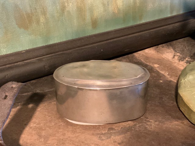
- Date
- 1800 – 1860
- Material
- metal
- Catalogue Number
- 102.04.0198
- Description
- An oval, flat-based box, with a flanged, hinged lid attached on the long side of the box which fits flushly into the box when closed. The lid is simply domed, as is the base which descends from the seam a few millimeters before extending flat.
1 image
- Title
- Trinket Box
- Date
- 1800 – 1860
- Material
- metal
- Dimensions
- 4.4 x 6.0 x 8.5 cm
- Description
- An oval, flat-based box, with a flanged, hinged lid attached on the long side of the box which fits flushly into the box when closed. The lid is simply domed, as is the base which descends from the seam a few millimeters before extending flat.
- Subject
- households
- decorative
- Credit
- Gift of Catharine Robb Whyte, O. C., Banff, 1979
- Catalogue Number
- 102.04.0198
Images
This material is presented as originally created; it may contain outdated cultural descriptions and
potentially offensive content.
Read more.
- Date
- 1850 – 1900
- Material
- wood
- Catalogue Number
- 102.04.0200
- Description
- A lathe-turned round-dish, flat-bottomed box with a domed, lapping lid which fits flushly over a flange on the box body. Box and lid are painted a boxcar red and decorated with designs of circles and flowers, varnish over paint has oxidized. Interior of box has been painted a dark green.
1 image
- Title
- Trinket Box
- Date
- 1850 – 1900
- Material
- wood
- Dimensions
- 6.3 x 13.0 cm
- Description
- A lathe-turned round-dish, flat-bottomed box with a domed, lapping lid which fits flushly over a flange on the box body. Box and lid are painted a boxcar red and decorated with designs of circles and flowers, varnish over paint has oxidized. Interior of box has been painted a dark green.
- Subject
- households
- decorative
- Credit
- Gift of Catharine Robb Whyte, O. C., Banff, 1979
- Catalogue Number
- 102.04.0200
Images

This material is presented as originally created; it may contain outdated cultural descriptions and
potentially offensive content.
Read more.
- Date
- 1800 – 1900
- Material
- metal
- Catalogue Number
- 102.04.0203
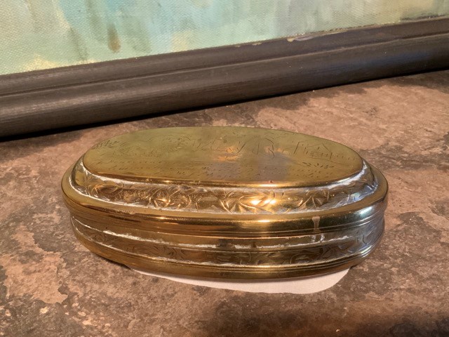
- Description
- An oval shaped brass box with lid attached by hinges so it can open completely. Lid fits flushly and smoothly over the lip of the body. Its overall appearance is of an oval with two domes that flatten for top and base. Picture inscribed in brass on top of a man and woman fighting while some rather …
1 image
- Title
- Trinket Box
- Date
- 1800 – 1900
- Material
- metal
- Dimensions
- 4.0 x 7.0 x 12.5 cm
- Description
- An oval shaped brass box with lid attached by hinges so it can open completely. Lid fits flushly and smoothly over the lip of the body. Its overall appearance is of an oval with two domes that flatten for top and base. Picture inscribed in brass on top of a man and woman fighting while some rather anthropomorphized animals smile on, a lion, bear, and monkey (?) the text accompanying translates from the Dutch: "Living animals you can tame, but in the world lives no man who can tame his wife.” On the base is an image of a man upon whom two women are spilling "slops" from a window, at left, while at right a harried man in a cave-break is being attacked by a gryphon and a lion, and a text, translated from the Dutch reads "I would rather not love or drink than make my resting place and home with an angry woman." Interior of box is painted black, which has blistered. Some of design has been polished away.
- Subject
- households
- decorative
- Credit
- Gift of Catharine Robb Whyte, O. C., Banff, 1979
- Catalogue Number
- 102.04.0203
Images
This material is presented as originally created; it may contain outdated cultural descriptions and
potentially offensive content.
Read more.
- Date
- 1800 – 1890
- Material
- wood
- Catalogue Number
- 102.04.0241
- Description
- Two-piece, egg-shaped, all black container. Deep lidded or two equal fitting parts. "No 39" sticker on flat end and other end footed, exterior lacquer has lost its gloss. Drawstring bag made from blue silk with gold embroidered pattern and green inner lining.
1 image
- Title
- Trinket Box
- Date
- 1800 – 1890
- Material
- wood
- Dimensions
- 9.6 cm
- Description
- Two-piece, egg-shaped, all black container. Deep lidded or two equal fitting parts. "No 39" sticker on flat end and other end footed, exterior lacquer has lost its gloss. Drawstring bag made from blue silk with gold embroidered pattern and green inner lining.
- Subject
- households
- decorative
- Japanese
- E. S. Morse
- Credit
- Gift of Catharine Robb Whyte, O. C., Banff, 1979
- Catalogue Number
- 102.04.0241
Images

This material is presented as originally created; it may contain outdated cultural descriptions and
potentially offensive content.
Read more.
Pat Brewster fonds
https://archives.whyte.org/en/permalink/descriptions15
- Part Of
- Pat Brewster fonds
- Scope & Content
- Fonds consists of four series: I. Personal, II. Professional, III. Activities, IV. Brewster family. I. Personal series, 1905-1982, 18 cm of textual records, 160 photographs, 2 sound recordings. Includes correspondence, interview and recorded conversation, address/notebook, artwork, other textua…
- Date Range
- 1841-1983
- Reference Code
- M2 / S21 / V91
- Description Level
- 1 / Fonds
- GMD
- Photograph
- Album
- Negative
- Photograph print
- Postcard
- Transparency
- Sound recording
- Cassette
- Textual record
- Drawing
- Map
- Poster
- Private record
- Part Of
- Pat Brewster fonds
- Description Level
- 1 / Fonds
- Fonds Number
- M2 / V91 / S21
- Sous-Fonds
- V91
- Accession Number
- 12, 13, 80, 93, 110, 145, 340, 380, 899, 1006, 1110, 1179, 1210, 1235, 1398, 1409, 1440, 1505, 1784, 1874, 2176, 2216, 2303, 2361, 2410, 2643, 2791, 2816, 2880, 2903, 2933, 2940, 3051, 3157, 3181, 3393, 3642, 3733, 3734, 3780, 3821, 3921, 3969, 5028, 5336, 6018
- Reference Code
- M2 / S21 / V91
- GMD
- Photograph
- Album
- Negative
- Photograph print
- Postcard
- Transparency
- Sound recording
- Cassette
- Textual record
- Drawing
- Map
- Poster
- Private record
- Date Range
- 1841-1983
- Physical Description
- ca.80 cm of textual material. -- ca.900 photographs : prints, postcards, transparencies, negatives, copy negatives. -- 1 photograph album (50 prints). -- 3 sound recordings : audio tape cassettes
- History / Biographical
- Forrest Oliver "Pat" Brewster, 1896-1982, was a trail guide, outfitter and businessman in Banff, Alberta, Canada. Pat was a native and life-long resident of Banff. As a boy, he was an active Boy Scout and, by age seventeen, was a big game guide. After serving in World War I, Brewster established the first permanent camp at Lake O'Hara for the Canadian Pacific Railway. In 1926, he took over the Brewster Transport Company outfitting business from his brothers, Bill and Jim. In the 1930s, he became involved in skiing explorations in the Assiniboine, Skoki and Sunshine areas. Pat Brewster was active in community affairs and, in his later years, was an avid historian of the region. He published three books of reminiscences between 1975 and 1982.
- Scope & Content
- Fonds consists of four series: I. Personal, II. Professional, III. Activities, IV. Brewster family.
- I. Personal series, 1905-1982, 18 cm of textual records, 160 photographs, 2 sound recordings. Includes correspondence, interview and recorded conversation, address/notebook, artwork, other textual records, photographs.
- II. Professional series, 1892-1982, 47.5 cm of textual records, 266 photographs, 1 sound recording. Includes papers pertaining to various Brewster family and other businesses, writing papers and sound recording, and photographs pertaining to guiding and outfitting, tourism promotion and other.
- III. Activities series, 1841-1983, 6.5 cm of textual records, 262 photographs. Pertains to genealogical research, other activities and collected material.
- IV. Brewster family series, 1841-1981, 2.5 cm of textual records, 132 photographs. Pertains to Brewster family, Jack Brewster, John Brewster, Pearl Brewster Moore and the Moore family.
- Name Access
- Brewster, Pat
- Access Restrictions
- Some restrictions on access to originals
- Copyright, privacy, commercial use and other restrictions may apply
- Language
- English
- Finding Aid
- Finding aids and reference tools: arrangement outline
- series and file description
- electronic finding aid
- reference copies and summaries for sound recordings
- Creator
- Brewster, Pat
- Title Source
- Title based on contents of fonds
- Processing Status
- Processed
This material is presented as originally created; it may contain outdated cultural descriptions and
potentially offensive content.
Read more.