Narrow Results By
- Luxton family fonds 113
- Nicholas Morant fonds 39
- George McLean fonds 36
- Kidney family fonds 35
- Joe Kootenay fonds 24
- Peter and Catharine Whyte fonds 18
- Alpine Club of Canada fonds 15
- Archives General File Collection 15
- Eliza Hunter fonds 14
- Trail Riders of the Canadian Rockies fonds 10
- Dorothy Cranstone fonds 8
- Dorothy Wardle fonds 8
"A" series. -- [ca.1940-ca.1960]
https://archives.whyte.org/en/permalink/descriptions712
- Part Of
- Georgia Engelhard fonds
- Scope & Content
- Consists of mountain climbing and scenic views taken in the Alps of Switzerland and Italy, the Canadian Rockies, the Himalayas and the Teton Mountains of Wyoming. Canadian Rockies views are mainly Lake Louise area and include the Victoria Glacier, Goat Peak and other features. Photographs taken i…
- Date Range
- ca. 1940 - ca.1950
- Reference Code
- V751 / PA - 1 to 117
- Description Level
- 4 / Sub-series
- GMD
- Photograph
- Photograph print
3 images
- Part Of
- Georgia Engelhard fonds
- Description Level
- 4 / Sub-series
- Fonds Number
- V751
- Series
- I. Georgia Engelhard photographs
- Sous-Fonds
- V751
- Accession Number
- .
- Reference Code
- V751 / PA - 1 to 117
- Date Range
- ca. 1940 - ca.1950
- Physical Description
- 117 photographs : prints
- Scope & Content
- Consists of mountain climbing and scenic views taken in the Alps of Switzerland and Italy, the Canadian Rockies, the Himalayas and the Teton Mountains of Wyoming. Canadian Rockies views are mainly Lake Louise area and include the Victoria Glacier, Goat Peak and other features. Photographs taken in Swiss Alps include Zermatt, the Matterhorn and Val D'Herens. Climbers photographed include Eaton Cromwell, renowned mountaineer (#6, 8, 87) and Edmund Petrig, prominent Swiss guide (#6, 8).
- Language
- English
- Title Source
- Title based on original numbering
- Processing Status
- Processed
Images


This material is presented as originally created; it may contain outdated cultural descriptions and
potentially offensive content.
Read more.
"1" series. -- [ca.1945]
https://archives.whyte.org/en/permalink/descriptions713
- Part Of
- Georgia Engelhard fonds
- Scope & Content
- Views pertain to the Teton Mountains of Wyoming and include a climber or guide named Walter
- Date Range
- ca, 1940 - ca. 1950
- Reference Code
- V751 / PA - 118 to 127
- Description Level
- 4 / Sub-series
- GMD
- Photograph
- Photograph print
- Part Of
- Georgia Engelhard fonds
- Description Level
- 4 / Sub-series
- Fonds Number
- V751
- Series
- I. Georgia Engelhard photographs
- Sous-Fonds
- V751
- Accession Number
- .
- Reference Code
- V751 / PA - 118 to 127
- Date Range
- ca, 1940 - ca. 1950
- Physical Description
- 10 photographs : prints
- Scope & Content
- Views pertain to the Teton Mountains of Wyoming and include a climber or guide named Walter
- Language
- English
- Title Source
- Title based on original numbering
- Processing Status
- Processed
This material is presented as originally created; it may contain outdated cultural descriptions and
potentially offensive content.
Read more.
"278" series. -- [ca.1940-ca.1960]
https://archives.whyte.org/en/permalink/descriptions717
- Part Of
- Georgia Engelhard fonds
- Scope & Content
- Series includes numerous views pertaining of the Canadian Rockies and other Canadian locations, including Lake Louise area, Victoria Glacier, Mount Athabasca, Mount Assiniboine, Pinnacle Mountain, Mount Collie, Murchison Group and Bobbie Burns Group. Also includes views of Switzerland, including Ze…
- Date Range
- ca. 1940 to ca. 1950
- Reference Code
- V751 / PA - 162 to 220
- Description Level
- 4 / Sub-series
- GMD
- Photograph
- Photograph print
3 images
- Part Of
- Georgia Engelhard fonds
- Description Level
- 4 / Sub-series
- Fonds Number
- V751
- Series
- I. Georgia Engelhard photographs
- Sous-Fonds
- V751
- Accession Number
- .
- Reference Code
- V751 / PA - 162 to 220
- Date Range
- ca. 1940 to ca. 1950
- Physical Description
- 59 photographs : prints
- Scope & Content
- Series includes numerous views pertaining of the Canadian Rockies and other Canadian locations, including Lake Louise area, Victoria Glacier, Mount Athabasca, Mount Assiniboine, Pinnacle Mountain, Mount Collie, Murchison Group and Bobbie Burns Group. Also includes views of Switzerland, including Zermatt and Engadine districts and the Matterhorn; Italian Alps (Dolomites); and Teton Mountains. Includes Edward Feuz (#164?, 167, 173, 191?), Eaton Cromwell (#167), Georgia Engelhard (#183, 187, 188), Edmund Petrig (#190), Emil and Rudi Perren and unidentified climbers.
- Language
- English
- Title Source
- Title based on original numbering
- Processing Status
- Processed
Images


This material is presented as originally created; it may contain outdated cultural descriptions and
potentially offensive content.
Read more.
Extended family records
https://archives.whyte.org/en/permalink/descriptions22344
- Part Of
- Luxton family fonds
- Scope & Content
- Records in this series consist of three sub-series: C.1. William Luxton family papers and photographs; C.2. McDougall and Ross families papers, correspondence, and photographs; C.3. Other extended family records. Sub-series C.1. consists of four sub-sub-series: William Luxton; Sarah Luxton; Geor…
- Date Range
- 1893-1970
- Reference Code
- LUX / III / C
- Description Level
- 3 / Series
- GMD
- Textual record
- Private record
- Photograph
- Photograph print
- Part Of
- Luxton family fonds
- Description Level
- 3 / Series
- Fonds Number
- LUX
- Series
- III.C. Extended Family
- Sous-Fonds
- III. Luxton Family sous-fonds
- Accession Number
- LUX
- Reference Code
- LUX / III / C
- Date Range
- 1893-1970
- Physical Description
- 0.28 m textual records ; ca.147 photographs : b&w prints; 15 x 21 cm or smaller
- Scope & Content
- Records in this series consist of three sub-series: C.1. William Luxton family papers and photographs; C.2. McDougall and Ross families papers, correspondence, and photographs; C.3. Other extended family records. Sub-series C.1. consists of four sub-sub-series: William Luxton; Sarah Luxton; George Luxton; Louis Luxton. Sub-series C.2. consists of two sub-sub-series: McDougall family; Ross family.
- Language
- English
- Category
- Family and personal life
- Communications
- Title Source
- Title based on contents of series
- Processing Status
- Processed
This material is presented as originally created; it may contain outdated cultural descriptions and
potentially offensive content.
Read more.
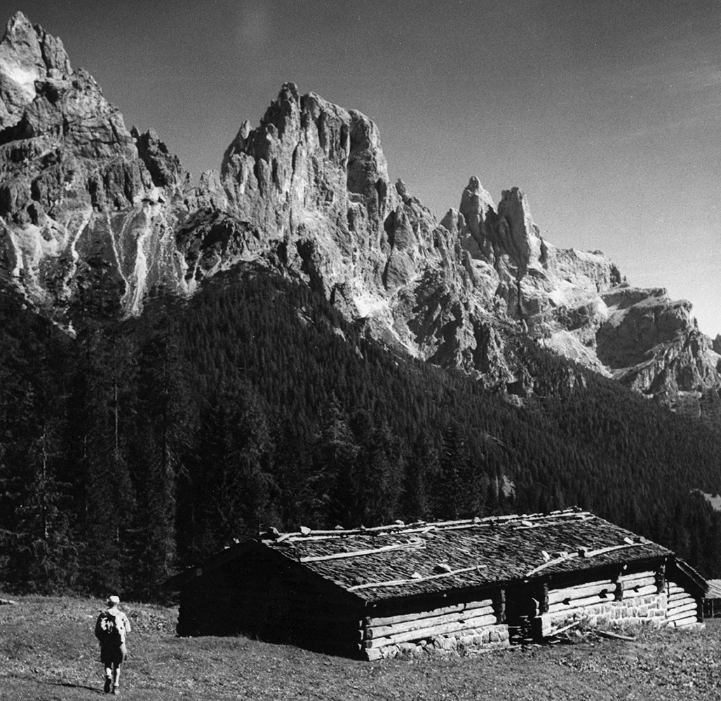
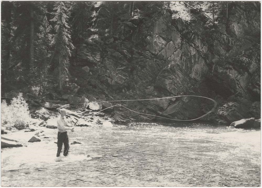
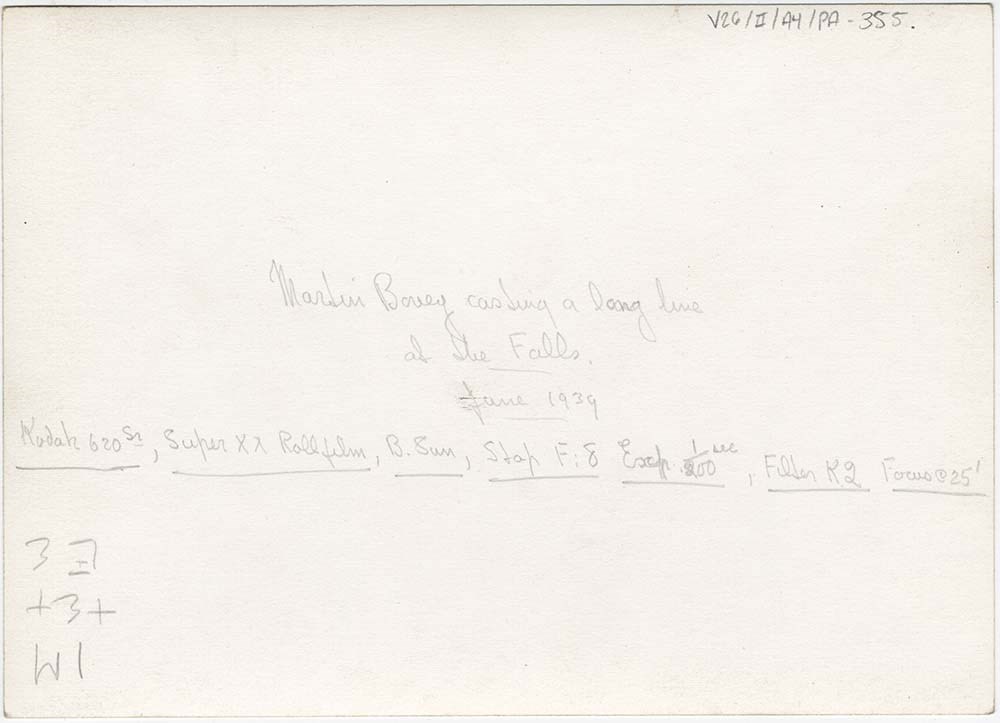
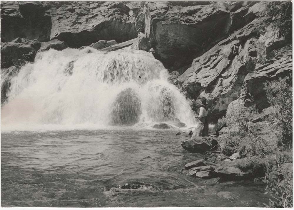
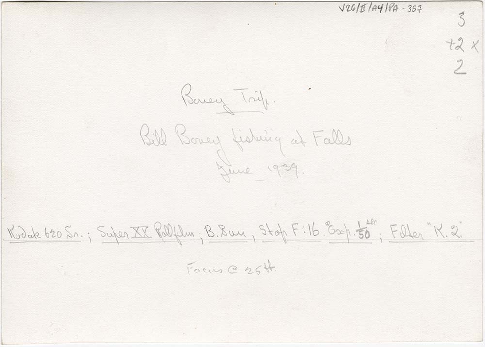
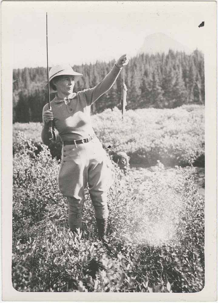
Bovey trips 1939 to 1941
https://archives.whyte.org/en/permalink/descriptions23425
- Part Of
- Bert Riggall fonds
- Scope & Content
- File consists of 26 b&w photographs, some captioned. Photographs pertain to the Bovey trips guided and outfitted by Riggall of 1939, 1940, and 1941. The photographs document the Bovey party in camp covered with snow, fishing, fishing, and making movies. Locations of photographs include Twin Lakes, …
- Date Range
- 1939, 1940, 1941
- Reference Code
- V26 / II / A4 / PA - 353 to 378
- Description Level
- 5 / File
- GMD
- Photograph
- Photograph print
4 images
- Part Of
- Bert Riggall fonds
- Description Level
- 5 / File
- Fonds Number
- M376 / V26
- Series
- II.Business and Financial: Client Papers and Photographs
- Sous-Fonds
- V26
- Reference Code
- V26 / II / A4 / PA - 353 to 378
- Date Range
- 1939, 1940, 1941
- Physical Description
- Photographs: 26 prints, b&w
- Scope & Content
- File consists of 26 b&w photographs, some captioned. Photographs pertain to the Bovey trips guided and outfitted by Riggall of 1939, 1940, and 1941. The photographs document the Bovey party in camp covered with snow, fishing, fishing, and making movies. Locations of photographs include Twin Lakes, Profanity Creek, and Larch Creek.
- Subject Access
- Guiding, Fishing, Camp
- Title Source
- Title based on contents of file
- Processing Status
- Processed
Images
This material is presented as originally created; it may contain outdated cultural descriptions and
potentially offensive content.
Read more.
Bert Riggall's 1000 Mile Pack trip
https://archives.whyte.org/en/permalink/descriptions23454
- Part Of
- Bert Riggall fonds
- Scope & Content
- File consists of 43 b&w photographs, some captioned. Photographs pertain to Riggall's 1911 1000 mile pack trip undertaken to seek out areas for hunting and outfitting following the enlargement of Waterton National Park and the reduction of available hunting area for Riggall's clients. The prints do…
- Date Range
- 1911
- Reference Code
- V26 / II / A7 / PA - 119 to 161
- Description Level
- 5 / File
- GMD
- Photograph
- Photograph print
1 image
- Part Of
- Bert Riggall fonds
- Description Level
- 5 / File
- Fonds Number
- M376 / V26
- Series
- II.Business and Financial: Bert Riggall's 1000 Mile Pack trip, 1911
- Sous-Fonds
- V26
- Accession Number
- 7201
- Reference Code
- V26 / II / A7 / PA - 119 to 161
- Date Range
- 1911
- Physical Description
- 43 photographs: b&w prints
- Scope & Content
- File consists of 43 b&w photographs, some captioned. Photographs pertain to Riggall's 1911 1000 mile pack trip undertaken to seek out areas for hunting and outfitting following the enlargement of Waterton National Park and the reduction of available hunting area for Riggall's clients. The prints document this pack trip from stops in Banff, AB and Cranbrook, BC, and the extent of his mountain exploration from Fort Steele to Edson. On this trip, approximately 150 miles of new trail was cut including portions of Roger's Pass.
- Subject Access
- Pack trips
- Exploration
- Trails
- Trail making
- Recreation
- Hunting
- Outfitters, trail guides and packers
- Geographic Access
- Canada
- Alberta
- Banff National Park
- Waterton National Park
- British Columbia
- Cranbrook
- Rogers Pass
- Language
- English
- Title Source
- Title based on contents of file
- Processing Status
- Processed
Images

This material is presented as originally created; it may contain outdated cultural descriptions and
potentially offensive content.
Read more.
Bert Riggall's 1000 Mile Pack trip
https://archives.whyte.org/en/permalink/descriptions23455
- Part Of
- Bert Riggall fonds
- Scope & Content
- File consists of 20 b&w photographs, some captioned. Photographs pertain to Riggall's 1911 1000 mile pack trip undertaken to seek out areas for hunting and outfitting following the enlargement of Waterton National Park and the reduction of available hunting area for Riggall's clients. The prints do…
- Date Range
- 1911
- Reference Code
- V26 / II / A7 / PA - 162 to 181
- Description Level
- 5 / File
- GMD
- Photograph
- Photograph print
1 image
- Part Of
- Bert Riggall fonds
- Description Level
- 5 / File
- Fonds Number
- M376 / V26
- Series
- II.Business and Financial: Bert Riggall's 1000 Mile Pack trip, 1911
- Sous-Fonds
- V26
- Accession Number
- 7201
- Reference Code
- V26 / II / A7 / PA - 162 to 181
- Date Range
- 1911
- Physical Description
- Photographs: 20 prints, b&w
- Scope & Content
- File consists of 20 b&w photographs, some captioned. Photographs pertain to Riggall's 1911 1000 mile pack trip undertaken to seek out areas for hunting and outfitting following the enlargement of Waterton National Park and the reduction of available hunting area for Riggall's clients. The prints document this pack trip from stops in Banff, AB and Cranbrook, BC, and the extent of his mountain exploration from Fort Steele to Edson. On this trip, approximately 150 miles of new trail was cut including portions of Roger's Pass.
- Subject Access
- Pack trips
- Exploration
- Trails
- Trail making
- Recreation
- Hunting
- Outfitters, trail guides and packers
- Geographic Access
- Canada
- Alberta
- Banff National Park
- Waterton National Park
- British Columbia
- Cranbrook
- Rogers Pass
- Language
- English
- Title Source
- Title based on contents of file
- Processing Status
- Processed
Images
This material is presented as originally created; it may contain outdated cultural descriptions and
potentially offensive content.
Read more.
Faegre and Dorsey Trips 1935 to 1945
https://archives.whyte.org/en/permalink/descriptions23467
- Part Of
- Bert Riggall fonds
- Scope & Content
- File consists of 32 b&w photographs, some captioned. Photographs pertain to the Faegre and Dorsey Trips 1935 to 1945. The photographs document camp life, hiking, climbing, pack trains, and fishing. Locations of photographs include Boundary Meadow, Herbst Glacier, Kishinena, Wall Lake, and the Oldma…
- Date Range
- 1935, 1939, 1942, 1945
- Reference Code
- V26 / III / A15 / PA - 1 to 32
- Description Level
- 5 / File
- GMD
- Photograph
- Photograph print
2 images
- Part Of
- Bert Riggall fonds
- Description Level
- 5 / File
- Fonds Number
- M376 / V26
- Series
- III. Professional Photography: Guiding and Hunting Trips
- Sous-Fonds
- V26
- Reference Code
- V26 / III / A15 / PA - 1 to 32
- Date Range
- 1935, 1939, 1942, 1945
- Physical Description
- Photographs: 32 prints, b&w
- Scope & Content
- File consists of 32 b&w photographs, some captioned. Photographs pertain to the Faegre and Dorsey Trips 1935 to 1945. The photographs document camp life, hiking, climbing, pack trains, and fishing. Locations of photographs include Boundary Meadow, Herbst Glacier, Kishinena, Wall Lake, and the Oldman River.
- Subject Access
- Hunting, Guiding, Climbing
- Title Source
- Title based on contents of file
- Processing Status
- Processed
Images

This material is presented as originally created; it may contain outdated cultural descriptions and
potentially offensive content.
Read more.
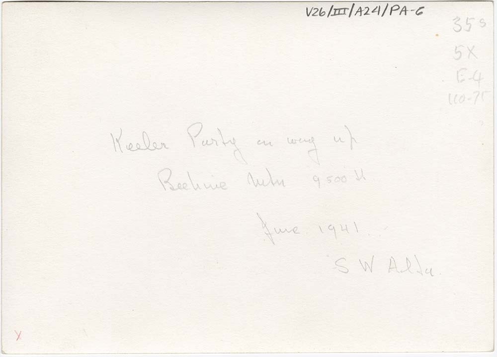
Various Client Trips
https://archives.whyte.org/en/permalink/descriptions23471
- Part Of
- Bert Riggall fonds
- Scope & Content
- File consists of 21 b&w photographs, some captioned. Photographs pertain to the following client trips: Keeler, Norton & Haglin, 1941; Chapin, 1942. The photographs document camp life, hiking, climbing, pack trains, picnicking, and fishing. Locations of photographs include Beehive Pass, Beehive mou…
- Date Range
- 1941, 1942
- Reference Code
- V26 / III / A24 / PA - 1 to V26 / III / A25 / PA - 10
- Description Level
- 5 / File
- GMD
- Photograph
- Photograph print
4 images
- Part Of
- Bert Riggall fonds
- Description Level
- 5 / File
- Fonds Number
- M376 / V26
- Series
- III. Professional Photography: Guiding and Hunting Trips
- Sous-Fonds
- V26
- Reference Code
- V26 / III / A24 / PA - 1 to V26 / III / A25 / PA - 10
- Date Range
- 1941, 1942
- Physical Description
- Photographs: 21 prints, b&w
- Scope & Content
- File consists of 21 b&w photographs, some captioned. Photographs pertain to the following client trips: Keeler, Norton & Haglin, 1941; Chapin, 1942. The photographs document camp life, hiking, climbing, pack trains, picnicking, and fishing. Locations of photographs include Beehive Pass, Beehive mountain, Slacker Creek, Oldman River, the "Gap" District, Twin Lakes, Kintla Creek, and Wall Lake.
- Subject Access
- Guiding, Climbing, Hiking.
- Title Source
- Title based on contents of file
- Content Details
- V26 / III / A24 / PA - 1 to 11 Pertain to the trip, Keeler, Norton & Haglin trip, 1941.
- V26 / III / A25 / PA - 1 to 10 Pertain to the Chapin trip, 1942.
- Processing Status
- Processed
Images


This material is presented as originally created; it may contain outdated cultural descriptions and
potentially offensive content.
Read more.
[Mountain View 82 H/4 East - Alberta]
https://archives.whyte.org/en/permalink/catalogue23785
- Medium
- Library - Maps and blueprints (unannotated; published)
- Map
- Published Date
- 1944
- Publisher
- Dept. of Mines and Technical Surveys
- Call Number
- NTS
- 82H/4E
- Publisher
- Dept. of Mines and Technical Surveys
- Published Date
- 1944
- Physical Description
- Black and White
- Scale
- Scale: 1:50,000
- Relief: Contour interval 100'
- Subjects
- Mountain View 82 H/4 East - Alberta
- Notes
- National Topographic System
- Call Number
- NTS
- 82H/4E
- Collection
- Archives Library
This material is presented as originally created; it may contain outdated cultural descriptions and
potentially offensive content.
Read more.
[Pincher Creek 82 H/5 West]
https://archives.whyte.org/en/permalink/catalogue23820
- Medium
- Library - Maps and blueprints (unannotated; published)
- Map
- Published Date
- 1944
- Publisher
- Dept. of the Mines and Technical Surveys
- Call Number
- NTS
- 82H/5W
- Publisher
- Dept. of the Mines and Technical Surveys
- Published Date
- 1944
- Physical Description
- Black and White
- Scale
- Scale: 1:50,000
- Relief: Contour interval 100'
- Subjects
- Pincher Creek 82 H/5 West
- Notes
- National Topographic System
- Call Number
- NTS
- 82H/5W
- Collection
- Archives Library
This material is presented as originally created; it may contain outdated cultural descriptions and
potentially offensive content.
Read more.
National parks of Canada : Banff Park, Alberta
https://archives.whyte.org/en/permalink/catalogue24289
- Medium
- Library - Maps and blueprints (unannotated; published)
- Map
- Published Date
- 1946, 1932
- Publisher
- Ottawa : Hydrographic and Map Service
- Edition
- Compiled, drawn and printed July 1932; reprinted with corrections 1946
- Call Number
- C2-1.3
- Edition
- Compiled, drawn and printed July 1932; reprinted with corrections 1946
- Publisher
- Ottawa : Hydrographic and Map Service
- Published Date
- 1946, 1932
- Physical Description
- 1 map : col
- Scale
- Scale: 1:190,080
- Subjects
- Banff National Park
- Accession Number
- 3350
- 3349 deaccessioned
- Call Number
- C2-1.3
- Collection
- Archives Library
This material is presented as originally created; it may contain outdated cultural descriptions and
potentially offensive content.
Read more.
Map of central part of Jasper from surveys by M.P. Bridgland
https://archives.whyte.org/en/permalink/catalogue24294
- Medium
- Library - Maps and blueprints (unannotated; published)
- Map
- Published Date
- 1917
- Publisher
- Department of the Interior
- Call Number
- C2-2.1
- Responsibility
- from surveys by M. P. Bridgland
- Publisher
- Department of the Interior
- Published Date
- 1917
- Physical Description
- 6 sheets : col
- Scale
- Scale: 1.014 in. = 1 mile
- Relief: Contour interval: 100 ft.
- Subjects
- Jasper National Park
- Accession Number
- 512
- 718
- Call Number
- C2-2.1
- Collection
- Archives Library
This material is presented as originally created; it may contain outdated cultural descriptions and
potentially offensive content.
Read more.
Preliminary map of the Canadian Rocky Mtns between Jarvis Pass and Yellowhead Pass showing the route followed by Mary Jobe in August 1914|Mary Jobe's trip through the northern Rockies
https://archives.whyte.org/en/permalink/catalogue24304
- Medium
- Library - Maps and blueprints (unannotated; published)
- Map
- Published Date
- 1915
- Publisher
- Bulletin of the American Geographic Society, vol. XLV11, 7
- Call Number
- C6-3.9(a)
- C6-3.9(b)
- Publisher
- Bulletin of the American Geographic Society, vol. XLV11, 7
- Published Date
- 1915
- Scale
- 1:300,000
- Subjects
- Rocky Mountains
- Canadian
- Notes
- xerox copy of M.67, M2.1
- Accession Number
- 6500
- Call Number
- C6-3.9(a)
- C6-3.9(b)
- Collection
- Archives Library
This material is presented as originally created; it may contain outdated cultural descriptions and
potentially offensive content.
Read more.
Sketch map of the Lake O'Hara region
https://archives.whyte.org/en/permalink/catalogue24331
- Medium
- Library - Maps and blueprints (unannotated; published)
- Map
- Published Date
- 1949-1950
- Rev. 1954, 1955, 1964
- Call Number
- C6-4.4 d-i
- Responsibility
- compiled by George K.K. Link and A. Carson
- Published Date
- 1949-1950
- Rev. 1954, 1955, 1964
- Physical Description
- 6 maps
- Scale
- 2 inches = 1 mile
- Notes
- [Lake O'Hara?, 1950-1964]
- All annotated and colored in different ways
- Accession Number
- 238
- 3347
- 3069
- 3069 (dup.) (e)
- Infofile transfer (f)
- Call Number
- C6-4.4 d-i
- Collection
- Archives Library
This material is presented as originally created; it may contain outdated cultural descriptions and
potentially offensive content.
Read more.
AAF aeronautical chart : North Saskatchewan River / compiled for the U.S. Army Air Forces by the U.S. Coast and Geodetic Survey
https://archives.whyte.org/en/permalink/catalogue24364
- Medium
- Library - Maps and blueprints (unannotated; published)
- Map
- Published Date
- 1943
- Publisher
- Washington, D.C.
- Call Number
- C6-12.1
- Publisher
- Washington, D.C.
- Published Date
- 1943
- Physical Description
- 1 map : col
- Scale
- 1 : 1,000,000
- Subjects
- Saskatchewan River, North
- Aviation
- Accession Number
- 4008
- Call Number
- C6-12.1
- Collection
- Archives Library
This material is presented as originally created; it may contain outdated cultural descriptions and
potentially offensive content.
Read more.
Map of Pelly, Ross and Gravel Rivers
https://archives.whyte.org/en/permalink/catalogue24369
- Medium
- Library - Maps and blueprints (unannotated; published)
- Map
- Published Date
- 1910
- Publisher
- Dept. of Mines and Geological Survey
- Call Number
- C8-1.3
- Publisher
- Dept. of Mines and Geological Survey
- Published Date
- 1910
- Scale
- 8 miles to 1 inch
- Subjects
- Yukon and North West Territories
- Notes
- Sources of info: G.M. Dawson, R.G. McConn., J. Keele, W. Ogilvie
- Accession Number
- 576
- Call Number
- C8-1.3
- Collection
- Archives Library
This material is presented as originally created; it may contain outdated cultural descriptions and
potentially offensive content.
Read more.
Province of Alberta
https://archives.whyte.org/en/permalink/catalogue24409
- Medium
- Library - Maps and blueprints (unannotated; published)
- Map
- Published Date
- 1947
- Publisher
- Alberta Dept. of Lands and Mines
- Call Number
- C9-1.19
- Publisher
- Alberta Dept. of Lands and Mines
- Published Date
- 1947
- Physical Description
- 1 map
- Scale
- Scale: 1 inch = 16 miles
- Subjects
- Alberta
- Notes
- In oversize cabinet (rolled up)
- Accession Number
- 6406
- Call Number
- C9-1.19
- Collection
- Archives Library
This material is presented as originally created; it may contain outdated cultural descriptions and
potentially offensive content.
Read more.
Alberta : Athabaska sheet
https://archives.whyte.org/en/permalink/catalogue24415
- Medium
- Library - Maps and blueprints (unannotated; published)
- Map
- Published Date
- 1914
- Publisher
- Ottawa: Office of the Surveyor General
- Edition
- 2d ed.
- Call Number
- C9-2.4
- Edition
- 2d ed.
- Publisher
- Ottawa: Office of the Surveyor General
- Published Date
- 1914
- Physical Description
- 1 map
- Scale
- Scale: 1:190,080
- Subjects
- Athabaska River
- Notes
- Sectional map
- Accession Number
- 5576
- 4008
- Call Number
- C9-2.4
- Collection
- Archives Library
This material is presented as originally created; it may contain outdated cultural descriptions and
potentially offensive content.
Read more.
[Alberta] South-central portion
https://archives.whyte.org/en/permalink/catalogue24416
- Medium
- Library - Maps and blueprints (unannotated; published)
- Map
- Published Date
- 1910
- Publisher
- Dept. of the Interior, Ottawa
- Call Number
- C9-3.1
- Publisher
- Dept. of the Interior, Ottawa
- Published Date
- 1910
- Scale
- Bench marks
- Subjects
- Alberta
- Notes
- 1 duplicate in map room - Accn. 400
- Accession Number
- 400
- Call Number
- C9-3.1
- Collection
- Archives Library
This material is presented as originally created; it may contain outdated cultural descriptions and
potentially offensive content.
Read more.