Narrow Results By
- Toyohara Kunichika 6
- Unknown 5
- Serena Matilda Potts (1812 – 1898, American) 4
- Yoshu Chikanobu (1838 – 1912, Japanese) 4
- Catlin, George 3
- Geological Survey of Canada 3
- Ballantyne, Robert Michael 2
- Canadian Pacific Railway 2
- Charles John Collings (1848 – 1931, British) 2
- Alcott, Louisa M. 1
- Appleton's Magazine 1
- Butler, William Francis 1
- 1970s 2948
- 1920s 2562
- 1960s 2324
- 1930s 2218
- 1910s 2068
- 1950s 1876
- 1980s 1873
- 1940s 1783
- 1900s 1375
- 1990s 1196
- 2000s 982
- 2010s 800
- 1890s 630
- 1870s
- 1880s 472
- 2020s 209
- 1850s 137
- 1800s 94
- 1860s 63
- 1820s
- 1830s 29
- 1810s 26
- 1840s 22
- 1780s 18
- 1790s 13
- 1750s 12
- 1700s 5
- 1770s 3
- 1600s 2
- 1720s
- 1080s 1
- 1300s 1
- 1500s 1
- 1530s 1
- 1550s 1
- 1620s 1
- 1690s 1
- 1760s 1
Map from the Pacific Ocean across the Rocky Mountain Zone
https://archives.whyte.org/en/permalink/catalogue24555
- Medium
- Library - Maps and blueprints (unannotated; published)
- Map
- Published Date
- January 1874
- Call Number
- C11-3.7
- Published Date
- January 1874
- Scale
- Scale: 1/1:584,000 or 25 English Statute miles to 1 inch
- Subjects
- Canada
- Railway routes
- Notes
- Accompanies: "Report on the Explorations and Surveys" 08.5/C16/rep.
- Accession Number
- 10,000
- Call Number
- C11-3.7
- Collection
- Archives Library
This material is presented as originally created; it may contain outdated cultural descriptions and
potentially offensive content.
Read more.
Canadian Pacific Railway chart of the Thunder Bay-Lake Superior
https://archives.whyte.org/en/permalink/catalogue24556
- Medium
- Library - Maps and blueprints (unannotated; published)
- Map
- Published Date
- January 1874
- Call Number
- C11-3.7(c)
- Responsibility
- Surveyed by Admiral Bayfield R.N.
- Published Date
- January 1874
- Scale
- Soundings are in feet
- Subjects
- Canada
- Railway routes
- Notes
- To accompany report of the Engineer in Chief, C.P.R. 08.5/C16/rep
- Accession Number
- 10,000
- Call Number
- C11-3.7(c)
- Collection
- Archives Library
This material is presented as originally created; it may contain outdated cultural descriptions and
potentially offensive content.
Read more.
Plans of the Rivers Kamanistiquia and Nepigon
https://archives.whyte.org/en/permalink/catalogue24557
- Medium
- Library - Maps and blueprints (unannotated; published)
- Map
- Published Date
- January 1874
- Publisher
- Canadian Pacific Railway 08.5/C16/rep
- Call Number
- C11-3.7(e)
- Publisher
- Canadian Pacific Railway 08.5/C16/rep
- Published Date
- January 1874
- Scale
- Kamenestiquia Plan: 4000' - 1 inch
- Subjects
- Canada
- Railway routes
- Notes
- To accompany report of the Engineer-in-chief
- Accession Number
- 10,000
- Call Number
- C11-3.7(e)
- Collection
- Archives Library
This material is presented as originally created; it may contain outdated cultural descriptions and
potentially offensive content.
Read more.
Topographical Survey
https://archives.whyte.org/en/permalink/catalogue24795
- Medium
- Library - Maps and blueprints (unannotated; published)
- Map
- Published Date
- 1879
- Call Number
- C12-1.23
- Published Date
- 1879
- Scale
- 8 miles: 1 inch
- Subjects
- North West Territory
- Notes
- Photostatic copy from Public Archives
- Accession Number
- 675
- Call Number
- C12-1.23
- Collection
- Archives Library
This material is presented as originally created; it may contain outdated cultural descriptions and
potentially offensive content.
Read more.
Drawing of Rocky Mountain by J.L.*
https://archives.whyte.org/en/permalink/catalogue21324
- Medium
- Library - Maps and blueprints (unannotated; published)
- Map
- Published Date
- 1873
- Call Number
- C4-5.2
- Published Date
- 1873
- Subjects
- Rocky Mountain House
- Notes
- Photostatic copy from Public Archives * See The Cairn, vol III, no. 2 last page re: Jean L'Heureux by E.J. Hart
- * See: The Cairn, vol III, no. 2 last page re: Jean L'Hereux by E.J. Hart
- Accession Number
- 675
- Call Number
- C4-5.2
- Collection
- Archives Library
This material is presented as originally created; it may contain outdated cultural descriptions and
potentially offensive content.
Read more.
French map of Canada and New France
https://archives.whyte.org/en/permalink/catalogue21420
- Medium
- Library - Maps and blueprints (unannotated; published)
- Map
- Published Date
- 1720
- Call Number
- C11-1.1
- Published Date
- 1720
- Subjects
- Canada
- Accession Number
- 499
- Call Number
- C11-1.1
- Collection
- Archives Library
This material is presented as originally created; it may contain outdated cultural descriptions and
potentially offensive content.
Read more.
Map of the country between the provinces of Ontario, Quebec and Manitoba
https://archives.whyte.org/en/permalink/catalogue21432
- Medium
- Library - Maps and blueprints (unannotated; published)
- Map
- Published Date
- January, 1874
- Call Number
- C11-3.7(a)
- Published Date
- January, 1874
- Subjects
- Canada
- Railway routes
- Notes
- Accompanies: "Report on the Explorations and Surveys" 08.5/C16/rep
- Distances from Fort Garry (The Stone Fort) to Toronto and Montreal. All rail routes
- Accession Number
- 10,000
- Call Number
- C11-3.7(a)
- Collection
- Archives Library
This material is presented as originally created; it may contain outdated cultural descriptions and
potentially offensive content.
Read more.
Canadian Pacific Railway sketch plan of the mouth of the Saskatchewan River from Hinds Exploring Expedition also plan and section of the Mossy Portage between Cedar Lake and Lake Winnipegoosis and the Meadow Portage
https://archives.whyte.org/en/permalink/catalogue21433
- Medium
- Library - Maps and blueprints (unannotated; published)
- Map
- Published Date
- From a survey by Henry B. Smith, 1873
- Call Number
- C11-3.7(b)
- Published Date
- From a survey by Henry B. Smith, 1873
- Subjects
- Canada
- Railway routes
- Notes
- Accompanies 08.5/C16/rep
- Accession Number
- 10,000
- Call Number
- C11-3.7(b)
- Collection
- Archives Library
This material is presented as originally created; it may contain outdated cultural descriptions and
potentially offensive content.
Read more.
Canadian Pacific Railway chart of Nepigon Bay Lake Superior
https://archives.whyte.org/en/permalink/catalogue21434
- Medium
- Library - Maps and blueprints (unannotated; published)
- Map
- Published Date
- January 1874
- Call Number
- C11-3.7(d)
- Responsibility
- Surveyed by Admiral Bayfield R.N.
- Published Date
- January 1874
- Subjects
- Canada
- Railway routes
- Notes
- To accompany: "Report of the Enginer in Chief Canadian Pacific Railway" 08.5/C16/
- Accession Number
- 10,000
- Call Number
- C11-3.7(d)
- Collection
- Archives Library
This material is presented as originally created; it may contain outdated cultural descriptions and
potentially offensive content.
Read more.
Chart of the Coast of British Columbia North of Latitude, 51 degrees chiefly from Captain Vancouver's Surveys in 1792 and 1793
https://archives.whyte.org/en/permalink/catalogue21435
- Medium
- Library - Maps and blueprints (unannotated; published)
- Map
- Published Date
- 1874
- Publisher
- C.P.R. 08.5/C16/rep
- Call Number
- C11-3.7(f)
- Publisher
- C.P.R. 08.5/C16/rep
- Published Date
- 1874
- Subjects
- Canada
- Railway routes
- Notes
- To accompany: Report of the Engineer-in-chief
- Accession Number
- 10,000
- Call Number
- C11-3.7(f)
- Collection
- Archives Library
This material is presented as originally created; it may contain outdated cultural descriptions and
potentially offensive content.
Read more.
Types of soil|Travelled routes
https://archives.whyte.org/en/permalink/catalogue21489
- Medium
- Library - Maps and blueprints (unannotated; published)
- Map
- Published Date
- 1879
- Call Number
- C12-1.14
- Published Date
- 1879
- Subjects
- Prairies
- Notes
- Photostatic copy from Public Archives
- two sections
- Accession Number
- 675
- Call Number
- C12-1.14
- Collection
- Archives Library
This material is presented as originally created; it may contain outdated cultural descriptions and
potentially offensive content.
Read more.
New discoveries in North America
https://archives.whyte.org/en/permalink/catalogue21494
- Medium
- Library - Maps and blueprints (unannotated; published)
- Map
- Published Date
- 1821
- Call Number
- C12-1.19
- Published Date
- 1821
- Subjects
- North America
- Notes
- Photostatic copy from Public Archives
- four sections
- Accession Number
- 675
- Call Number
- C12-1.19
- Collection
- Archives Library
This material is presented as originally created; it may contain outdated cultural descriptions and
potentially offensive content.
Read more.
An approximate classification of the lands
https://archives.whyte.org/en/permalink/catalogue21497
- Medium
- Library - Maps and blueprints (unannotated; published)
- Map
- Published Date
- 1878
- Call Number
- C12-1.22
- Published Date
- 1878
- Subjects
- North West Territory
- Notes
- Photostatic copy from Public Archives
- two sections
- Accession Number
- 675
- Call Number
- C12-1.22
- Collection
- Archives Library
This material is presented as originally created; it may contain outdated cultural descriptions and
potentially offensive content.
Read more.
North West Frontiers of India
https://archives.whyte.org/en/permalink/catalogue21528
- Medium
- Library - Maps and blueprints (unannotated; published)
- Map
- Published Date
- 1878
- Publisher
- W. & A.K. Johnston, Edinburgh
- Call Number
- C13-8.6
- Publisher
- W. & A.K. Johnston, Edinburgh
- Published Date
- 1878
- Subjects
- Afghanistan
- Accession Number
- 400
- Call Number
- C13-8.6
- Collection
- Archives Library
This material is presented as originally created; it may contain outdated cultural descriptions and
potentially offensive content.
Read more.
(Review of) A journal of voyages and travels in the interior of North America between the 47th and 58th degrees of North Latitude extending from Montreal nearly to the Pacific Ocean
https://archives.whyte.org/en/permalink/catalogue3748
- Medium
- Library - Book (including soft-cover and pamphlets)
- Published Date
- 1820
- Call Number
- 02.5 B77h
- Responsibility
- by D. M. Harmon, a partner in the North-West Company
- Published Date
- 1820
- Physical Description
- p.409-416
- Subjects
- British Columbia
- Notes
- From unknown periodical
- Accession Number
- 400
- Call Number
- 02.5 B77h
- Collection
- Archives Library
This material is presented as originally created; it may contain outdated cultural descriptions and
potentially offensive content.
Read more.
Memorial of Rev. George McDougall, Indian missionary to the Saskatchewan, with his last two letters
https://archives.whyte.org/en/permalink/catalogue8774
- Medium
- Library - Book (including soft-cover and pamphlets)
- Published Date
- 1876
- Publisher
- Montreal : "Witness" Publishing House
- Call Number
- 07.2 M14m Pam
- Publisher
- Montreal : "Witness" Publishing House
- Published Date
- 1876
- Physical Description
- 8p. : port
- Subjects
- Morley
- Notes
- Contents: Memorial of the late Rev. George McDougall / by Rev. Dr. Douglass; Letter to James Ferrier, December 17, 1875; Letter to James Ferrier, January 6, 1876; An-nee-me-ke : the son of Wah-bun-noo-sa; Account of Mr. McDougall's death
- Accession Number
- 3069
- Call Number
- 07.2 M14m Pam
- Collection
- Archives Library
This material is presented as originally created; it may contain outdated cultural descriptions and
potentially offensive content.
Read more.
Articles of a treaty
https://archives.whyte.org/en/permalink/catalogue8820
- Medium
- Library - Book (including soft-cover and pamphlets)
- Published Date
- 1878
- Call Number
- 07.2 Ar7 Pam
- Published Date
- 1878
- Physical Description
- p.xliv-li
- Subjects
- Treaty Number Seven
- Notes
- From Annual Report of the Department of the Interior for the Year Ended 30th June 1877
- Call Number
- 07.2 Ar7 Pam
- Collection
- Archives Library
This material is presented as originally created; it may contain outdated cultural descriptions and
potentially offensive content.
Read more.
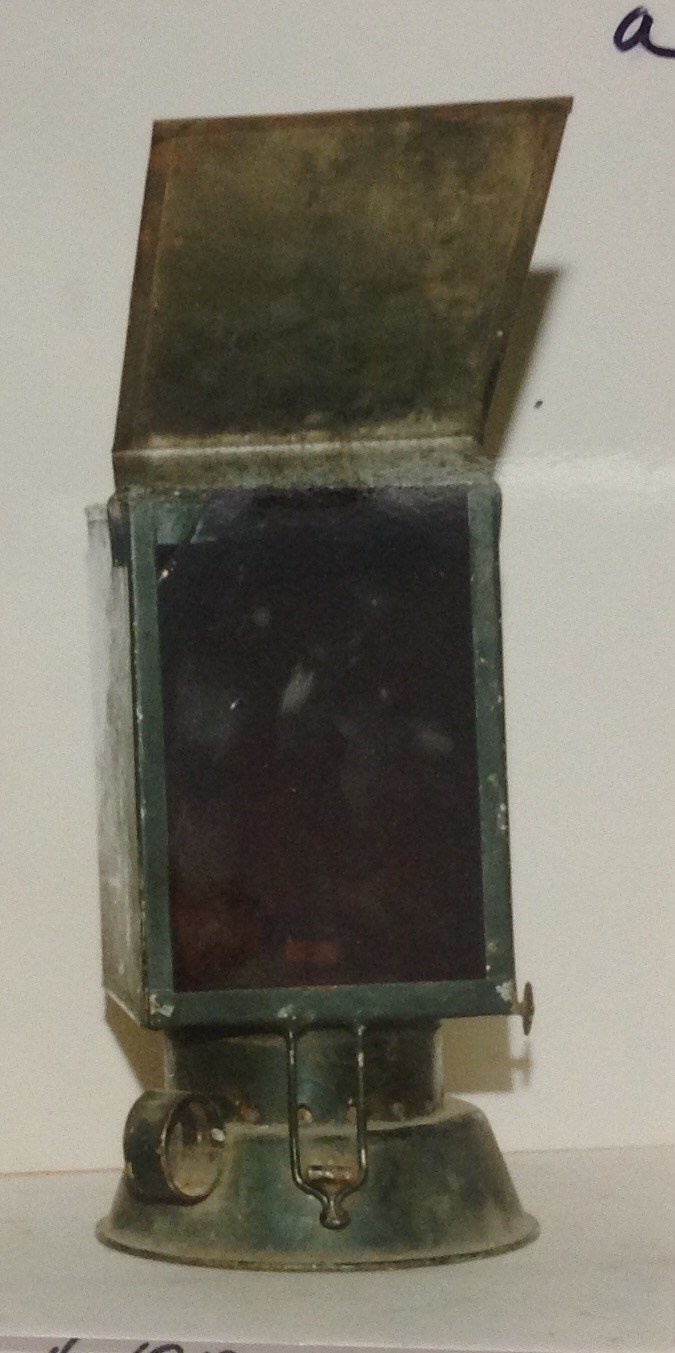
Kerosene Safelight
https://archives.whyte.org/en/permalink/artifact104.41.1056%20a
- Date
- 1870 – 1930
- Material
- metal
- Catalogue Number
- 104.41.1056 a
- Description
- Kerosene darkroom safe light, green; fuel tank as base, ring one side for carrying; wire clasp holds top unit down, hinged at back; wick; wick holder and turn knobs to lengthen wick in shielded area directly on top of fuel tank; hole in bottom of top unit (shade)where wick assembly enters; this rec…
1 image
- Title
- Kerosene Safelight
- Date
- 1870 – 1930
- Material
- metal
- Dimensions
- 10.0 x 20.3 x 10.0 cm
- Description
- Kerosene darkroom safe light, green; fuel tank as base, ring one side for carrying; wire clasp holds top unit down, hinged at back; wick; wick holder and turn knobs to lengthen wick in shielded area directly on top of fuel tank; hole in bottom of top unit (shade)where wick assembly enters; this rectangular box has a slot in front; a red sheet of glass is inserted, a flap (hinged at top) falls over the glass area;top of the box is a round extension which acts as a chimney; painted green.
- Subject
- photography
- Credit
- Gift of Robert N. Smith, Canmore, 1985
- Catalogue Number
- 104.41.1056 a
Images
This material is presented as originally created; it may contain outdated cultural descriptions and
potentially offensive content.
Read more.
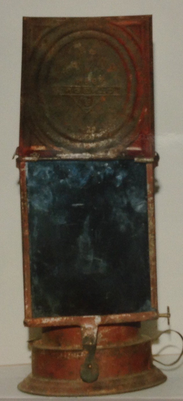
Kerosene Safelight
https://archives.whyte.org/en/permalink/artifact104.41.1056%20b
- Date
- 1870 – 1930
- Material
- metal
- Catalogue Number
- 104.41.1056 b
- Description
- Darkroom kerosene safe light, painted red; fuel tank as base, ring to one side for carrying; thin metal clasp in front holds down top unit; hinged at the back (broken); hole in bottom if unit allows wick assembly on fuel tank to be inserted; top unit (shade) has flat face with a rounded back; flap …
1 image
- Title
- Kerosene Safelight
- Date
- 1870 – 1930
- Material
- metal
- Dimensions
- 11.2 x 20.3 x 12.6 cm
- Description
- Darkroom kerosene safe light, painted red; fuel tank as base, ring to one side for carrying; thin metal clasp in front holds down top unit; hinged at the back (broken); hole in bottom if unit allows wick assembly on fuel tank to be inserted; top unit (shade) has flat face with a rounded back; flap falls over a red glass plate inserted in slots at face; hinged at top; rounded extension above shade acts as chimney.
- Subject
- photography
- Credit
- Gift of Robert N. Smith, Canmore, 1985
- Catalogue Number
- 104.41.1056 b
Images
This material is presented as originally created; it may contain outdated cultural descriptions and
potentially offensive content.
Read more.
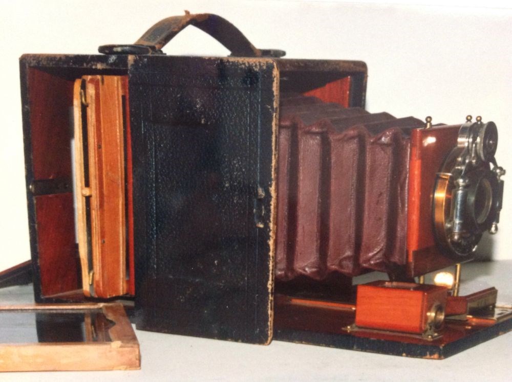
Folding Camera
https://archives.whyte.org/en/permalink/artifact104.41.1049
- Date
- 1870 – 1900
- Material
- wood, leather, glass, metal
- Catalogue Number
- 104.41.1049
- Description
- Folding plate camera with two plate holders; leather covered wood body with fold out bed; bellows - lens assembly rides on a brass track; distance indicator on left side "30" inscribed on the bed;optical viewfinder which tilts for use of vertical and horizontal shots; lens pole floats up/down on 2 …
1 image
- Title
- Folding Camera
- Date
- 1870 – 1900
- Material
- wood, leather, glass, metal
- Dimensions
- 17.7 x 15.2 x 12.5 cm
- Description
- Folding plate camera with two plate holders; leather covered wood body with fold out bed; bellows - lens assembly rides on a brass track; distance indicator on left side "30" inscribed on the bed;optical viewfinder which tilts for use of vertical and horizontal shots; lens pole floats up/down on 2 posts, geared knob on left side; shutter selection above lens; aperture selection below; shutter release on right right; Bausch &Lomb Opt. Co. lens; Model name plate; maroon leather bellows; 2 plateholders made of wood; brass fasteners; cardboard dividers; metal exposure guards; door on right side for inserting plate holders; door at back opens for fine focusing; leather carrying strap on top.
- Subject
- photography
- Credit
- Gift of Robert N. Smith, Canmore, 1985
- Catalogue Number
- 104.41.1049
Images
This material is presented as originally created; it may contain outdated cultural descriptions and
potentially offensive content.
Read more.