Narrow Results By
- 1970s 2547
- 1960s 1896
- 1950s 1549
- 1920s 1490
- 1980s 1420
- 1930s 1312
- 1900s 1278
- 1910s 1086
- 1940s 1073
- 1990s 1006
- 2000s 729
- 2010s 690
- 1890s 539
- 1870s
- 1880s 389
- 2020s 199
- 1850s 133
- 1800s 90
- 1860s 58
- 1820s 30
- 1840s
- 1780s 18
- 1830s 16
- 1750s 11
- 1790s 10
- 1810s 9
- 1700s 5
- 1600s 2
- 1720s
- 1770s 2
- 1080s 1
- 1300s 1
- 1500s 1
- 1530s 1
- 1550s 1
- 1620s 1
- 1690s 1
- 1760s 1
Memorial of Rev. George McDougall, Indian missionary to the Saskatchewan, with his last two letters
https://archives.whyte.org/en/permalink/catalogue8774
- Medium
- Library - Book (including soft-cover and pamphlets)
- Published Date
- 1876
- Publisher
- Montreal : "Witness" Publishing House
- Call Number
- 07.2 M14m Pam
- Publisher
- Montreal : "Witness" Publishing House
- Published Date
- 1876
- Physical Description
- 8p. : port
- Subjects
- Morley
- Notes
- Contents: Memorial of the late Rev. George McDougall / by Rev. Dr. Douglass; Letter to James Ferrier, December 17, 1875; Letter to James Ferrier, January 6, 1876; An-nee-me-ke : the son of Wah-bun-noo-sa; Account of Mr. McDougall's death
- Accession Number
- 3069
- Call Number
- 07.2 M14m Pam
- Collection
- Archives Library
This material is presented as originally created; it may contain outdated cultural descriptions and
potentially offensive content.
Read more.
Articles of a treaty
https://archives.whyte.org/en/permalink/catalogue8820
- Medium
- Library - Book (including soft-cover and pamphlets)
- Published Date
- 1878
- Call Number
- 07.2 Ar7 Pam
- Published Date
- 1878
- Physical Description
- p.xliv-li
- Subjects
- Treaty Number Seven
- Notes
- From Annual Report of the Department of the Interior for the Year Ended 30th June 1877
- Call Number
- 07.2 Ar7 Pam
- Collection
- Archives Library
This material is presented as originally created; it may contain outdated cultural descriptions and
potentially offensive content.
Read more.
Map from the Pacific Ocean across the Rocky Mountain Zone
https://archives.whyte.org/en/permalink/catalogue24555
- Medium
- Library - Maps and blueprints (unannotated; published)
- Map
- Published Date
- January 1874
- Call Number
- C11-3.7
- Published Date
- January 1874
- Scale
- Scale: 1/1:584,000 or 25 English Statute miles to 1 inch
- Subjects
- Canada
- Railway routes
- Notes
- Accompanies: "Report on the Explorations and Surveys" 08.5/C16/rep.
- Accession Number
- 10,000
- Call Number
- C11-3.7
- Collection
- Archives Library
This material is presented as originally created; it may contain outdated cultural descriptions and
potentially offensive content.
Read more.
Canadian Pacific Railway chart of the Thunder Bay-Lake Superior
https://archives.whyte.org/en/permalink/catalogue24556
- Medium
- Library - Maps and blueprints (unannotated; published)
- Map
- Published Date
- January 1874
- Call Number
- C11-3.7(c)
- Responsibility
- Surveyed by Admiral Bayfield R.N.
- Published Date
- January 1874
- Scale
- Soundings are in feet
- Subjects
- Canada
- Railway routes
- Notes
- To accompany report of the Engineer in Chief, C.P.R. 08.5/C16/rep
- Accession Number
- 10,000
- Call Number
- C11-3.7(c)
- Collection
- Archives Library
This material is presented as originally created; it may contain outdated cultural descriptions and
potentially offensive content.
Read more.
Plans of the Rivers Kamanistiquia and Nepigon
https://archives.whyte.org/en/permalink/catalogue24557
- Medium
- Library - Maps and blueprints (unannotated; published)
- Map
- Published Date
- January 1874
- Publisher
- Canadian Pacific Railway 08.5/C16/rep
- Call Number
- C11-3.7(e)
- Publisher
- Canadian Pacific Railway 08.5/C16/rep
- Published Date
- January 1874
- Scale
- Kamenestiquia Plan: 4000' - 1 inch
- Subjects
- Canada
- Railway routes
- Notes
- To accompany report of the Engineer-in-chief
- Accession Number
- 10,000
- Call Number
- C11-3.7(e)
- Collection
- Archives Library
This material is presented as originally created; it may contain outdated cultural descriptions and
potentially offensive content.
Read more.
Topographical Survey
https://archives.whyte.org/en/permalink/catalogue24795
- Medium
- Library - Maps and blueprints (unannotated; published)
- Map
- Published Date
- 1879
- Call Number
- C12-1.23
- Published Date
- 1879
- Scale
- 8 miles: 1 inch
- Subjects
- North West Territory
- Notes
- Photostatic copy from Public Archives
- Accession Number
- 675
- Call Number
- C12-1.23
- Collection
- Archives Library
This material is presented as originally created; it may contain outdated cultural descriptions and
potentially offensive content.
Read more.
Drawing of Rocky Mountain by J.L.*
https://archives.whyte.org/en/permalink/catalogue21324
- Medium
- Library - Maps and blueprints (unannotated; published)
- Map
- Published Date
- 1873
- Call Number
- C4-5.2
- Published Date
- 1873
- Subjects
- Rocky Mountain House
- Notes
- Photostatic copy from Public Archives * See The Cairn, vol III, no. 2 last page re: Jean L'Heureux by E.J. Hart
- * See: The Cairn, vol III, no. 2 last page re: Jean L'Hereux by E.J. Hart
- Accession Number
- 675
- Call Number
- C4-5.2
- Collection
- Archives Library
This material is presented as originally created; it may contain outdated cultural descriptions and
potentially offensive content.
Read more.
French map of Canada and New France
https://archives.whyte.org/en/permalink/catalogue21420
- Medium
- Library - Maps and blueprints (unannotated; published)
- Map
- Published Date
- 1720
- Call Number
- C11-1.1
- Published Date
- 1720
- Subjects
- Canada
- Accession Number
- 499
- Call Number
- C11-1.1
- Collection
- Archives Library
This material is presented as originally created; it may contain outdated cultural descriptions and
potentially offensive content.
Read more.
Map of the country between the provinces of Ontario, Quebec and Manitoba
https://archives.whyte.org/en/permalink/catalogue21432
- Medium
- Library - Maps and blueprints (unannotated; published)
- Map
- Published Date
- January, 1874
- Call Number
- C11-3.7(a)
- Published Date
- January, 1874
- Subjects
- Canada
- Railway routes
- Notes
- Accompanies: "Report on the Explorations and Surveys" 08.5/C16/rep
- Distances from Fort Garry (The Stone Fort) to Toronto and Montreal. All rail routes
- Accession Number
- 10,000
- Call Number
- C11-3.7(a)
- Collection
- Archives Library
This material is presented as originally created; it may contain outdated cultural descriptions and
potentially offensive content.
Read more.
Canadian Pacific Railway sketch plan of the mouth of the Saskatchewan River from Hinds Exploring Expedition also plan and section of the Mossy Portage between Cedar Lake and Lake Winnipegoosis and the Meadow Portage
https://archives.whyte.org/en/permalink/catalogue21433
- Medium
- Library - Maps and blueprints (unannotated; published)
- Map
- Published Date
- From a survey by Henry B. Smith, 1873
- Call Number
- C11-3.7(b)
- Published Date
- From a survey by Henry B. Smith, 1873
- Subjects
- Canada
- Railway routes
- Notes
- Accompanies 08.5/C16/rep
- Accession Number
- 10,000
- Call Number
- C11-3.7(b)
- Collection
- Archives Library
This material is presented as originally created; it may contain outdated cultural descriptions and
potentially offensive content.
Read more.
Canadian Pacific Railway chart of Nepigon Bay Lake Superior
https://archives.whyte.org/en/permalink/catalogue21434
- Medium
- Library - Maps and blueprints (unannotated; published)
- Map
- Published Date
- January 1874
- Call Number
- C11-3.7(d)
- Responsibility
- Surveyed by Admiral Bayfield R.N.
- Published Date
- January 1874
- Subjects
- Canada
- Railway routes
- Notes
- To accompany: "Report of the Enginer in Chief Canadian Pacific Railway" 08.5/C16/
- Accession Number
- 10,000
- Call Number
- C11-3.7(d)
- Collection
- Archives Library
This material is presented as originally created; it may contain outdated cultural descriptions and
potentially offensive content.
Read more.
Chart of the Coast of British Columbia North of Latitude, 51 degrees chiefly from Captain Vancouver's Surveys in 1792 and 1793
https://archives.whyte.org/en/permalink/catalogue21435
- Medium
- Library - Maps and blueprints (unannotated; published)
- Map
- Published Date
- 1874
- Publisher
- C.P.R. 08.5/C16/rep
- Call Number
- C11-3.7(f)
- Publisher
- C.P.R. 08.5/C16/rep
- Published Date
- 1874
- Subjects
- Canada
- Railway routes
- Notes
- To accompany: Report of the Engineer-in-chief
- Accession Number
- 10,000
- Call Number
- C11-3.7(f)
- Collection
- Archives Library
This material is presented as originally created; it may contain outdated cultural descriptions and
potentially offensive content.
Read more.
Route of Lieut. Warre and Lieut. Vavasour from Red River to the Pacific Ocean
https://archives.whyte.org/en/permalink/catalogue21476
- Medium
- Library - Maps and blueprints (unannotated; published)
- Map
- Published Date
- 1845
- Call Number
- C12-1.3
- Published Date
- 1845
- Subjects
- Western Canada
- Notes
- Photostatic copy from Public Archives
- Accession Number
- 675
- Call Number
- C12-1.3
- Collection
- Archives Library
This material is presented as originally created; it may contain outdated cultural descriptions and
potentially offensive content.
Read more.
Types of soil|Travelled routes
https://archives.whyte.org/en/permalink/catalogue21489
- Medium
- Library - Maps and blueprints (unannotated; published)
- Map
- Published Date
- 1879
- Call Number
- C12-1.14
- Published Date
- 1879
- Subjects
- Prairies
- Notes
- Photostatic copy from Public Archives
- two sections
- Accession Number
- 675
- Call Number
- C12-1.14
- Collection
- Archives Library
This material is presented as originally created; it may contain outdated cultural descriptions and
potentially offensive content.
Read more.
An approximate classification of the lands
https://archives.whyte.org/en/permalink/catalogue21497
- Medium
- Library - Maps and blueprints (unannotated; published)
- Map
- Published Date
- 1878
- Call Number
- C12-1.22
- Published Date
- 1878
- Subjects
- North West Territory
- Notes
- Photostatic copy from Public Archives
- two sections
- Accession Number
- 675
- Call Number
- C12-1.22
- Collection
- Archives Library
This material is presented as originally created; it may contain outdated cultural descriptions and
potentially offensive content.
Read more.
North West Frontiers of India
https://archives.whyte.org/en/permalink/catalogue21528
- Medium
- Library - Maps and blueprints (unannotated; published)
- Map
- Published Date
- 1878
- Publisher
- W. & A.K. Johnston, Edinburgh
- Call Number
- C13-8.6
- Publisher
- W. & A.K. Johnston, Edinburgh
- Published Date
- 1878
- Subjects
- Afghanistan
- Accession Number
- 400
- Call Number
- C13-8.6
- Collection
- Archives Library
This material is presented as originally created; it may contain outdated cultural descriptions and
potentially offensive content.
Read more.
Mountain And Mining Transit
https://archives.whyte.org/en/permalink/artifact104.44.1015
- Date
- 1870 – 1900
- Material
- wood; metal; glass; fibre; paper
- Catalogue Number
- 104.44.1015
- Description
- Gurley M&M (mountain and mining) transit. Original wooden box contains blued and brass instrument, field tools, sun shade fitting, ground cloth, plumb bob, etc. Paper labels inside lid of box.
1 image
- Title
- Mountain And Mining Transit
- Date
- 1870 – 1900
- Material
- wood; metal; glass; fibre; paper
- Dimensions
- 32.0 x 25.0 cm
- Description
- Gurley M&M (mountain and mining) transit. Original wooden box contains blued and brass instrument, field tools, sun shade fitting, ground cloth, plumb bob, etc. Paper labels inside lid of box.
- Subject
- photography
- Vaux family
- surveying
- Credit
- Gift of Hugh J. McCauley, Bryn Mawr, USA, 1999
- Catalogue Number
- 104.44.1015
Images

This material is presented as originally created; it may contain outdated cultural descriptions and
potentially offensive content.
Read more.
- Date
- 1870 – 1900
- Material
- wood; metal
- Catalogue Number
- 104.44.1018
- Description
- Large wooden tripod for use with transit (104.44.1015). Varnished wood with collapsing (telescoping) three legs with brass leg points and thumb screws for leg adjustments. The top bezel of threaded brass has a round wooden cover cap. Brass leg brackets are stamped: “W. & L.E. GURLEY, TROY, N.Y.”
1 image
- Title
- Tripod
- Date
- 1870 – 1900
- Material
- wood; metal
- Dimensions
- 93.0 x 9.0 cm
- Description
- Large wooden tripod for use with transit (104.44.1015). Varnished wood with collapsing (telescoping) three legs with brass leg points and thumb screws for leg adjustments. The top bezel of threaded brass has a round wooden cover cap. Brass leg brackets are stamped: “W. & L.E. GURLEY, TROY, N.Y.”
- Subject
- photography
- Vaux family
- surveying
- Credit
- Gift of Hugh J. McCauley, Bryn Mawr, USA, 1999
- Catalogue Number
- 104.44.1018
Images

This material is presented as originally created; it may contain outdated cultural descriptions and
potentially offensive content.
Read more.
- Date
- 1870 – 1972
- Material
- metal; sinew
- Catalogue Number
- 104.35.3002
- Description
- Metal tube with six round holes down the length and rectangular opening near mouthpiece wrapped with sinew. Orange “ALBERTA STONEY INDIAN HAND CRAFTS MORLEY - ALBERTA” tag with CRW’s writing on reverse: “Born 1876 about Edwin Dixon died June 15 ‘72 The flute given moon on geese Mar 1st 1876 Old …
1 image
- Title
- Flute
- Date
- 1870 – 1972
- Material
- metal; sinew
- Dimensions
- 1.4 x 1.4 x 30.8 cm
- Description
- Metal tube with six round holes down the length and rectangular opening near mouthpiece wrapped with sinew. Orange “ALBERTA STONEY INDIAN HAND CRAFTS MORLEY - ALBERTA” tag with CRW’s writing on reverse: “Born 1876 about Edwin Dixon died June 15 ‘72 The flute given moon on geese Mar 1st 1876 Old flute given by Hudson Bay Maria Lefthand.”
- Credit
- Gift of Catharine Robb Whyte, O. C., Banff, 1979
- Catalogue Number
- 104.35.3002
Images
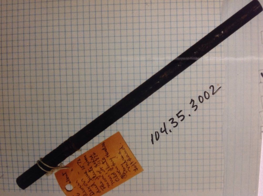
This material is presented as originally created; it may contain outdated cultural descriptions and
potentially offensive content.
Read more.
- Date
- 1870 – 1890
- Material
- fibre; skin; metal, brass; wood
- Catalogue Number
- 106.06.3018
- Description
- Braided leather lash (97.0 cm long) with a fur band at the centre and a piece of red fabric tied to the end. The lash is attached to a tapered wooden handle decorated with brass tacks. There is a fabric lined fur strip (cuff?) attached to the narrow end of the handle with a shell fastener.
1 image
- Title
- Whip
- Date
- 1870 – 1890
- Material
- fibre; skin; metal, brass; wood
- Dimensions
- 53.0 x 26.0 cm
- Description
- Braided leather lash (97.0 cm long) with a fur band at the centre and a piece of red fabric tied to the end. The lash is attached to a tapered wooden handle decorated with brass tacks. There is a fabric lined fur strip (cuff?) attached to the narrow end of the handle with a shell fastener.
- Subject
- Indigenous
- Gordon Cecil
- Credit
- Gift of Catharine Robb Whyte, O. C., Banff, 1979
- Catalogue Number
- 106.06.3018
Images
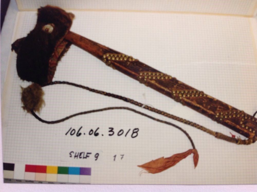
This material is presented as originally created; it may contain outdated cultural descriptions and
potentially offensive content.
Read more.