Narrow Results By
Ben Gadd fonds
https://archives.whyte.org/en/permalink/descriptions55758
- Part Of
- Ben Gadd fonds
- Scope & Content
- Fonds consists of materials pertaining to Ben Gadd's personal life and career as an environmental researcher, educator, interpretive guide, publisher, public speaker and author, ca.1956-2018. Fonds includes maps, research materials, publication notes/drafts, correspondence, contracts, photographs, …
- Date Range
- 1956-2018
- Reference Code
- M590 / V810 / S61
- Description Level
- 1 / Fonds
- GMD
- Digital image
- Drawing
- Negative
- Newspaper clipping
- Photograph
- Photograph print
- Postcard
- Published record
- Textual record
- Video
- Transparency
- Part Of
- Ben Gadd fonds
- Description Level
- 1 / Fonds
- Fonds Number
- M590
- V810
- Sous-Fonds
- M590
- V810
- Accession Number
- 2021.20
- 2024.01
- Reference Code
- M590 / V810 / S61
- GMD
- Digital image
- Drawing
- Negative
- Newspaper clipping
- Photograph
- Photograph print
- Postcard
- Published record
- Textual record
- Video
- Transparency
- Date Range
- 1956-2018
- Physical Description
- ca. 7.9 metres of textual records -- ca. 274 maps -- 29 VHS tapes -- ca.15 discs with digital files -- 21 cassettes -- photographs -- oversized materials -- USB stick with 15 sldeshows
- History / Biographical
- Ben Gadd (1946-) is a retired naturalist, guide, geologist, instructor, freelance writer and award-winning author based in the Canadian Rockies. Ben was born in Colorado Springs, Colorado in 1946. He met his wife, Cia (Langdon) Gadd at Colorado College in 1965, and the couple married four weeks later. Ben and Cia had two sons, Will and Toby. Ben and his family relocated to Jasper in the late 1960s. Ben later attended the University of Lethbridge and graduated with a Bachelor's degree in Earth Science in 1972. Between 1976 and 1980, Ben taught classes at Mount Royal College and the Southern Alberta Institute of Technology; he later taught additional classes at Grant MacEwan College and Lakeland College. From 1981, Ben also worked as a seasonal naturalist/guide for Parks Canada. Ben left Parks Canada in 1985 to start an independent naturalist guiding business with Cia based in Jasper and other parts of the Canadian Rockies, which the couple continued to operate for over two decades. Ben published his best-known work, "Handbook of the Canadian Rockies", through his publishing company Corax Press in 1986. The second edition of "Handbook of the Canadian Rockies" received multiple awards after its release in 1995. Ben's fiction book, "Raven's End" won the title of Best Canadian Rockies Book at the Banff Mountain Film and Book Festival in 2001 and became a Canadian bestseller. Overall, Ben has authored or co-authored 11 books and received nearly one dozen awards for his achievements as a writer, researcher and guide. Ben continued to lead guided hikes and school programs until his retirement in 2016.
- Scope & Content
- Fonds consists of materials pertaining to Ben Gadd's personal life and career as an environmental researcher, educator, interpretive guide, publisher, public speaker and author, ca.1956-2018. Fonds includes maps, research materials, publication notes/drafts, correspondence, contracts, photographs, video and sound recordings, and other related material. Materials donated in 2024 include one USB stick containing
- Notes
- Ben Gadd fonds arrangement: Series I : Personal records - Subseries A : Travel guides and maps - Subseries B : Education and early writings - Subseries C : Personal interest files - Subseries D : Other personal and collected Series II : Research and publication records - Subseries A : Handbook of the Canadian Rockies - Subseries B : Other publications Series III : Professional records - Subseries A : Parks Canada Records - Subseries B : Interpretive guiding - Subseries C : Teaching records - Subseries D : Other contracts and projects Series IV : Legal and financial records - Subseries A : Legal records - Subseries B : Financial records
- Subject Access
- Education
- Research
- Publication
- Environment
- Geology
- Tourism
- Family and personal life
- Personal and Professional Life
- Academics
- Guiding
- Guides
- Businesses
- Finances
- Conservation
- Wildlife
- Natural history
- Sports and recreation
- Geographic Access
- Canada
- Alberta
- Jasper National Park
- Banff National Park
- Yoho National Park
- Kootenay National Park
- Lethbridge
- United States of America
- Colorado
- Canadian Rocky Mountains
- Reproduction Restrictions
- Copyright restrictions apply
- Language
- English
- French
- Dutch
- Title Source
- Title based on contents of fonds
- Processing Status
- Processed / Unprocessed
This material is presented as originally created; it may contain outdated cultural descriptions and
potentially offensive content.
Read more.
Margaret Oliver fonds
https://archives.whyte.org/en/permalink/descriptions55186
- Part Of
- Margaret Oliver fonds
- Scope & Content
- Fonds consists of transparency slides, maps, handwritten notes and club records, song books, and scrapbooks pertaining to Margaret Ruth Oliver and the Tuesday Hikers club.
- Date Range
- 1971-2010
- Reference Code
- M569 / V793
- Description Level
- 1 / Fonds
- GMD
- Textual record
- Photograph
- Transparency
- Published record
- Private record
- Scrapbook
- Map
- Organization record
- Part Of
- Margaret Oliver fonds
- Description Level
- 1 / Fonds
- Fonds Number
- M569 / V793
- Sous-Fonds
- M569
- V793
- Accession Number
- 2017.8656
- Reference Code
- M569 / V793
- GMD
- Textual record
- Photograph
- Transparency
- Published record
- Private record
- Scrapbook
- Map
- Organization record
- Date Range
- 1971-2010
- Physical Description
- 28 photographs : col. slides -- 1.5 m of textual records (3 binders -- 1 record book -- 10 song books -- maps, annotated -- 11 scrapbooks)
- History / Biographical
- Margaret Ruth Oliver was born on December 19, 1927 to parents Edgar and Gladys (Brazier) Hammett in Winnipeg, Manitoba. Margaret's siblings include Dorothy (1922), Muriel "Miv" (1923), John (1929), and Jean (1933). Margaret graduated from United College (Winnipeg) in 1949 with a B.Sc. degree, and worked as an Assistant Librarian at the University of Manitoba afterwards. Margaret later enrolled in a Laboratory Technician program at the University of Manitoba Medical College. Margaret married Thomas Albert Oliver, a fellow University of Manitoba alumnus, on September 25, 1954. The couple moved to Calgary for work (Thomas taught at the University of Calgary, and Margaret worked for a geophysical company). Margaret travelled extensively following the death of her husband in 1997, visiting places such as Nepal, Cambodia, Russia, Egypt and Greenland. In 1971, Margaret formed a hiking group within the University Faculty Women's Club (F.W.C.) through the University of Calgary. In 1976, this group became a private club called the Tuesday Hikers, which no longer held any affiliation to the F.W.C. Trips included weekly hikes and/or ski trips, as well as longer backpacking excursions.The club is still active as of 2022.
- Scope & Content
- Fonds consists of transparency slides, maps, handwritten notes and club records, song books, and scrapbooks pertaining to Margaret Ruth Oliver and the Tuesday Hikers club.
- Notes
- Materials are unprocessed and stored in three boxes: Box 1: 1 envelope "T. Hikers' Slides" - 28 film transparencies and printed notes; various maps with handwritten notes Box 2: 1 record book "T.H. Record Book" - handwritten lists and statistics of trips, attendance, miles; 2 binders with handwritten notes, titled "National Parks - Banff and Assiniboine" and "Nat'l Parks - Glacier + Jasper" Box 3: 1 binder titled "Tues. Hikers- Past Members and Guests"; 10 song books; trail, park and road maps; 11 scrapbooks, 1971-2010
- Name Access
- Oliver, Margaret
- Subject Access
- Hiking
- Travel
- Recreation
- Club
- Map
- Trails
- Music
- Entertainment
- Geography
- Geographic Access
- Canada
- Alberta
- Banff National Park
- Jasper National Park
- Assiniboine
- British Columbia
- Glacier National Park
- Language
- English
- Biographical Source Notes
- https://biblio.uottawa.ca/en/node/16056
- Title Source
- Title based on content in fonds
- Processing Status
- Unprocessed
This material is presented as originally created; it may contain outdated cultural descriptions and
potentially offensive content.
Read more.
Jean Knox Petrie fonds
https://archives.whyte.org/en/permalink/descriptions615
- Part Of
- Jean Knox Petrie fonds
- Scope & Content
- Fonds relate to mountaineering with the Alpine Club of Canada. The fond consists of three series: I. Textual records consist of 8 newsclippings from July 1938 pertaining to the first ascent of Mount Columbia by women: Lillian Gest, Kathleen Chapman, Christine Reid, Jean McDonald, and Jean Petrie as…
- Date Range
- 1938-1940
- Reference Code
- M237 / V281
- Description Level
- 1 / Fonds
- GMD
- Photograph
- Album
- Map
- Photograph print
- Textual record
- Private record
- Published record
- Part Of
- Jean Knox Petrie fonds
- Description Level
- 1 / Fonds
- Fonds Number
- M 237
- V 281
- Sous-Fonds
- M 237
- V 281
- Accession Number
- 7694
- Reference Code
- M237 / V281
- Date Range
- 1938-1940
- Physical Description
- 1 cm textual records. -- 8 albums (257 photographs : b&w ; 25 x 20 cm or smaller). -- 4 photographs : b&w silver gelatin prints ; 20 x 25 cm or smaller.
- History / Biographical
- Dr. Jean Knox (McDonald) Petrie, born 1913, was an active member of the Alpine Club of Canada, Edmonton Section during the 1930s and 1940s, attending the Alpine Club of Canada summer camps from 1937-1940, 1942 and 1946 as well as making many weekend climbs in the Jasper area with Captain E. R. Gibson. In 1938 she was one of the four women to make a first ascent of Mount Columbia by women, as well as Mount Forbes in 1940. Married in 1960 to Robert Petrie (died 1966), Dr. Jean Petrie worked in Ottawa, Ontario (1940-1945) in munitions gauge testing for the National Research Council. Following the war, she worked as an astrophysicist for the Dominion Astrophysical Observatory in Victoria, British Columbia (1945-1966) and taught at the University of British Columbia in Vancouver, British Columbia. (1966-1971).
- Scope & Content
- Fonds relate to mountaineering with the Alpine Club of Canada. The fond consists of three series: I. Textual records consist of 8 newsclippings from July 1938 pertaining to the first ascent of Mount Columbia by women: Lillian Gest, Kathleen Chapman, Christine Reid, Jean McDonald, and Jean Petrie as well as a photocopied "Guide to the Tonquin" signed by K. G. Chapman ca.1935. II. Photographic records include an unbound album of 44 pages: 111 prints divided by the donor into 3 sections: 1. To the Tonquin Valley, July 1938; 2. Alpine Club Camp, Columbia Icefields, July 12-31, 1938; 3. Alpine Club Camp Tonquin Valley, April 1939. The album also includes artwork and map. A second unbound photograph album of 28p: 170 prints are divided into 5 sections: 1. ACC camp in the Ice River Valley, July 1939; 2. ACC ski camp in Little Yoho Valley, March 23-31, 1940; 3. Our climb of Roche Miette, May 24, 1940; 4. Our summertime journey into the Little Yoho Valley, July 1940; 5. Our climb of Mts. Fitzwilliam & Bucephelas, September 3, 1940. III. Photographic Prints consist of 4 loose prints unrelated to other contents of the fond.
- Notes
- Unbound books are numbered in pencil by the creator, pages appear to be missing due to absent page numbers.
- Name Access
- Petrie, Jean K.
- McDonald, Jean
- Gale, Ethne
- Taylor, Morris
- Cooper, Art
- Rault, Reg
- Brewster, Norman
- Cassils, Mary
- Hind, Rob
- Chapman, Kathleen
- Gibson, Rex
- Feuz, Edward
- Gest, Illian
- Walker, Hazel
- Carscallan, Alan
- McLean, Hector
- Subject Access
- Alpine Club of Canada
- Ski lodges and cabins
- Ski touring
- Skiing
- Backcountry skiing
- Banff Jasper Highway
- Cabins and shelters
- Camps
- Glaciers
- Huts
- Mountaineering
- Sunshine Lodge
- Trail guides
- Trail making
- Trails
- Winter sports
- Geographic Access
- Jasper National Park
- Yoho National Park
- Alberta
- Canada
- Banff National Park
- Language
- Language is English
- Finding Aid
- No finding aid
- Creator
- Petrie, Jean Knox
- Biographical Source Notes
- Accession record
- Donor
- Title Source
- Title based on contents of fonds
- Processing Status
- Processed
This material is presented as originally created; it may contain outdated cultural descriptions and
potentially offensive content.
Read more.
Travel guides - Banff National Park, Mount Assiniboine
https://archives.whyte.org/en/permalink/descriptions55921
- Part Of
- Ben Gadd fonds
- Scope & Content
- File consists of travel guides collected by Ben Gadd pertaining Banff National Park and Mount Assiniboine.
- Date Range
- [ca.2000]
- Reference Code
- M590 / I / A / i / 5
- Description Level
- 5 / File
- GMD
- Published record
- Textual record
- Map
- Part Of
- Ben Gadd fonds
- Description Level
- 5 / File
- Fonds Number
- M590
- V810
- S61
- Series
- M590 / I : Personal records
- Sous-Fonds
- M590
- Sub-Series
- M590 / I / A : Travel guides and maps
- Accession Number
- 2021.20
- Reference Code
- M590 / I / A / i / 5
- Date Range
- [ca.2000]
- Physical Description
- 2 cm of textual records
- Scope & Content
- File consists of travel guides collected by Ben Gadd pertaining Banff National Park and Mount Assiniboine.
- Subject Access
- Geography
- Travel
- Tourism
- Tourist information
- Geographic Access
- Canada
- Alberta
- Banff National Park
- Mount Assiniboine
- Reproduction Restrictions
- Copyright restrictions may apply
- Language
- English
- Category
- Exploration, discovery and travel
- Title Source
- Title based on contents of file
- Processing Status
- Processed
This material is presented as originally created; it may contain outdated cultural descriptions and
potentially offensive content.
Read more.
Travel guides and maps
https://archives.whyte.org/en/permalink/descriptions56361
- Part Of
- Ben Gadd fonds
- Scope & Content
- Sub-series consists of travel brochures and maps which were collected and used by Ben Gadd. Sub-series contains five sub-sub series: M590 / I / A / i : Travel guides and pocket maps M590 / I / A / ii : Topographical maps M590 / I / A / iii : Geological maps M590 / I / A / iv : Highway maps M590 / …
- Date Range
- [ca.1920-2010]
- Reference Code
- M590 / I / A
- Description Level
- 4 / Sub-series
- GMD
- Map
- Textual record
- Part Of
- Ben Gadd fonds
- Description Level
- 4 / Sub-series
- Fonds Number
- M590
- V810
- S61
- Series
- M590 / I : Personal records
- Sous-Fonds
- M590
- Sub-Series
- M590 / I / A : Travel guides and maps
- Accession Number
- 2021.20
- Reference Code
- M590 / I / A
- GMD
- Map
- Textual record
- Date Range
- [ca.1920-2010]
- Physical Description
- ca. 274 maps -- ca. 61 travel guides, brochures
- Scope & Content
- Sub-series consists of travel brochures and maps which were collected and used by Ben Gadd. Sub-series contains five sub-sub series: M590 / I / A / i : Travel guides and pocket maps M590 / I / A / ii : Topographical maps M590 / I / A / iii : Geological maps M590 / I / A / iv : Highway maps M590 / I / A / v : Index maps, other
- Notes
- Some materials in sub-series are annotated with notes by Ben Gadd
- Name Access
- Gadd, Ben
- Subject Access
- Geography
- Geology
- Environment
- Map
- Tourism
- Tourist information
- Travel
- Trails
- Roads
- Transportation
- Natural history
- National parks and reserves
- Provincial parks and reserves
- Government
- Sports
- Recreation
- Hiking
- Geographic Access
- Canada
- Alberta
- British Columbia
- Banff National Park
- Jasper National Park
- Kootenay National Park
- Yoho National Park
- Waterton Lakes National Park
- Columbia Icefields
- United States of America
- Colorado
- Montana
- Yellowstone National Park
- Access Restrictions
- Restrictions may apply - some materials are fragile
- Reproduction Restrictions
- Restrictions may apply
- Language
- English
- Conservation
- Some fragile/torn materials stored in mylar
- Category
- Environment
- Exploration, discovery and travel
- Government
- Sports, recreation and leisure
- Transportation
- Tourism
- Title Source
- Title based on contents of sub-series
- Processing Status
- Processed
This material is presented as originally created; it may contain outdated cultural descriptions and
potentially offensive content.
Read more.
Portrait of Bruno Engler
https://archives.whyte.org/en/permalink/descriptions57277
- Part Of
- Archives General File Collection
- Scope & Content
- File consists of 1 b&w sketch of Bruno Engler, titled: Bruno Engler Mountain Legend 1975, signed by Carol Bortenlanger 1 b&w photograph of Bruno Engler
- Date Range
- 1975
- Reference Code
- V8 / 2014.8284
- Description Level
- 5 / File
- GMD
- Photograph
- Photograph print
- Drawing
- Part Of
- Archives General File Collection
- Description Level
- 5 / File
- Fonds Number
- M8
- V8
- S8
- Series
- V8 / 2014.8284
- Sous-Fonds
- V8
- Accession Number
- 2014.8284
- Reference Code
- V8 / 2014.8284
- Date Range
- 1975
- Physical Description
- 1 photographs : b&w ; 20 x 16 cm and 1 pencil drawing
- Scope & Content
- File consists of 1 b&w sketch of Bruno Engler, titled: Bruno Engler Mountain Legend 1975, signed by Carol Bortenlanger
- 1 b&w photograph of Bruno Engler
- Name Access
- Engler, Bruno
- Bortenlanger, Carol
- Geographic Access
- Canada
- Alberta
- Banff National Park
- Language
- English
- Title Source
- Title based on contents of file
- Processing Status
- Processed
This material is presented as originally created; it may contain outdated cultural descriptions and
potentially offensive content.
Read more.
Portrait of Bruno Engler
https://archives.whyte.org/en/permalink/descriptions57278
- Part Of
- Archives General File Collection
- Scope & Content
- File consists of 1 8 x 10 photograph (print) and 1 photocopy (ca. 1923) pertaining to Vancouver Amazon women's hockey team. The photograph depicts the team with filming crew.
- Date Range
- ca. 1923
- Reference Code
- V8 / 2014.8279
- Description Level
- 5 / File
- GMD
- Photograph
- Photograph print
- Drawing
- Part Of
- Archives General File Collection
- Description Level
- 5 / File
- Fonds Number
- M8
- V8
- S8
- Series
- V8 / 2014.8279
- Sous-Fonds
- V8
- Accession Number
- 2014.8279
- Reference Code
- V8 / 2014.8279
- Date Range
- ca. 1923
- Physical Description
- 1 photographs : b&w ; 25 x 20 cm
- Scope & Content
- File consists of 1 8 x 10 photograph (print) and 1 photocopy (ca. 1923) pertaining to Vancouver Amazon women's hockey team. The photograph depicts the team with filming crew.
- Geographic Access
- Canada
- Alberta
- Banff National Park
- Language
- English
- Title Source
- Title based on contents of file
- Processing Status
- Processed
This material is presented as originally created; it may contain outdated cultural descriptions and
potentially offensive content.
Read more.
Vancouver Amazon women's hockey team
https://archives.whyte.org/en/permalink/descriptions57279
- Part Of
- Archives General File Collection
- Scope & Content
- File consists of 1 8 x 10 photograph (print) and 1 photocopy (ca. 1923) pertaining to Vancouver Amazon women's hockey team. The photograph depicts the team with filming crew.
- Date Range
- ca. 1923
- Reference Code
- V8 / 2014.8279
- Description Level
- 5 / File
- GMD
- Photograph
- Photograph print
- Drawing
- Part Of
- Archives General File Collection
- Description Level
- 5 / File
- Fonds Number
- M8
- V8
- S8
- Series
- V8 / 2014.8279
- Sous-Fonds
- V8
- Accession Number
- 2014.8279
- Reference Code
- V8 / 2014.8279
- Date Range
- ca. 1923
- Physical Description
- 1 photographs : b&w ; 25 x 20 cm
- Scope & Content
- File consists of 1 8 x 10 photograph (print) and 1 photocopy (ca. 1923) pertaining to Vancouver Amazon women's hockey team. The photograph depicts the team with filming crew.
- Geographic Access
- Canada
- Alberta
- Banff National Park
- Language
- English
- Title Source
- Title based on contents of file
- Processing Status
- Processed
This material is presented as originally created; it may contain outdated cultural descriptions and
potentially offensive content.
Read more.
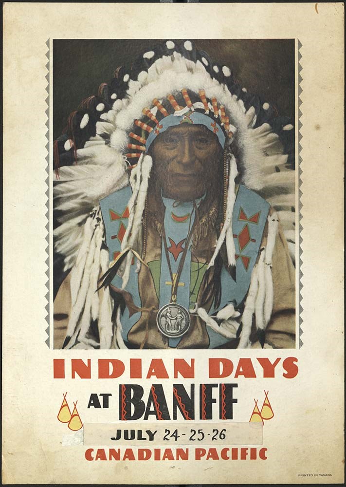
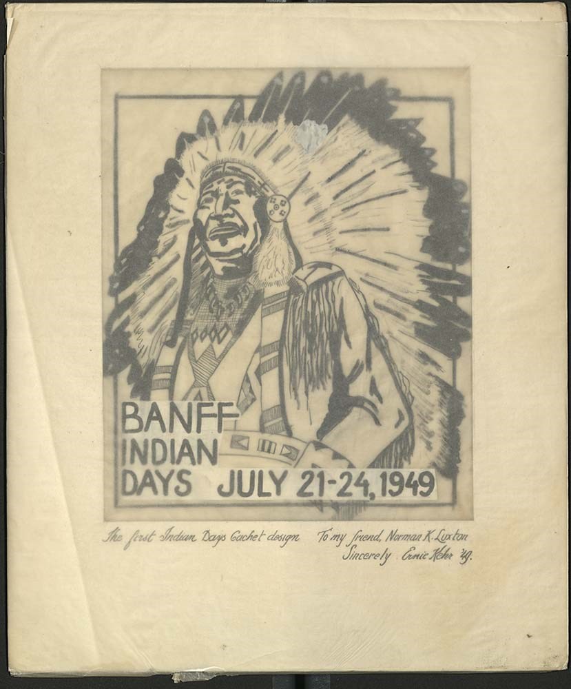
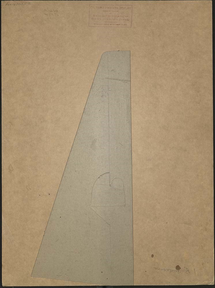
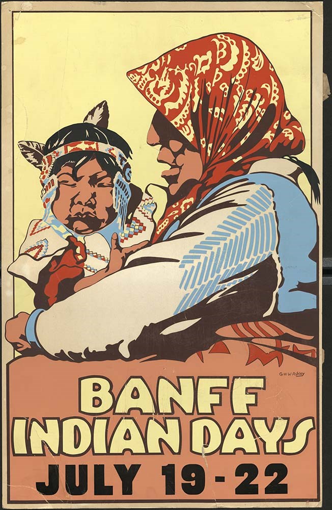
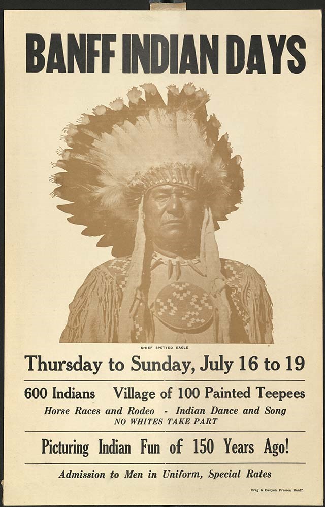
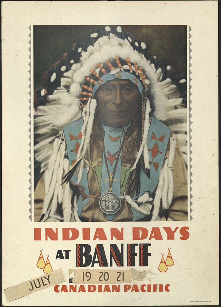
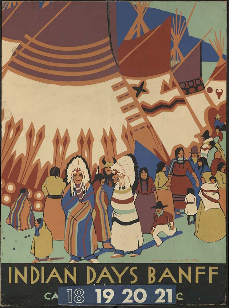
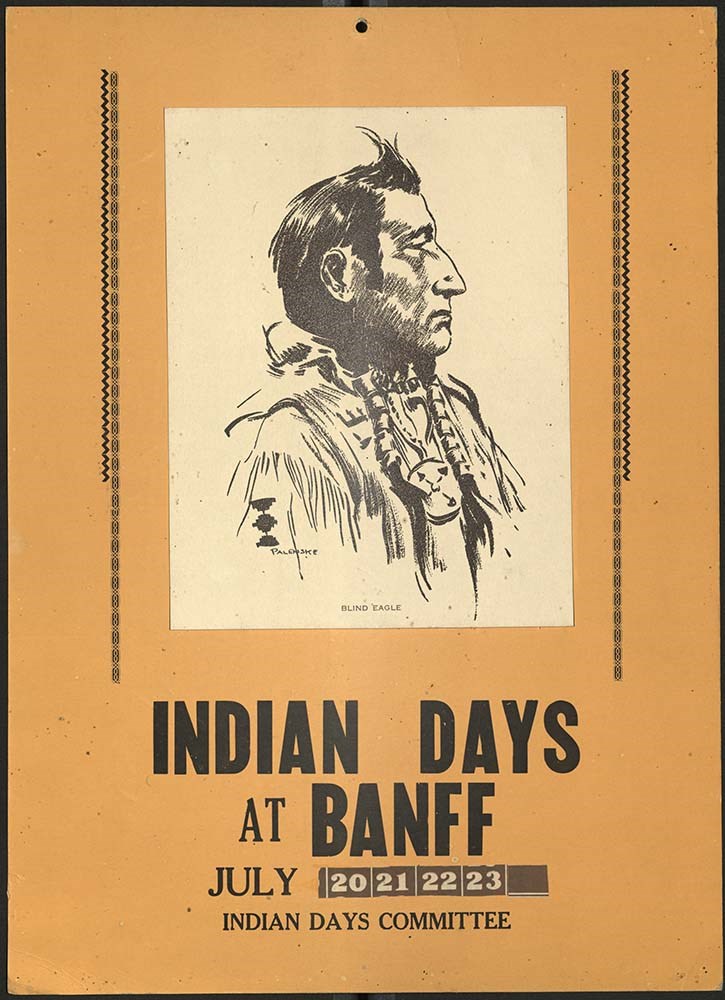
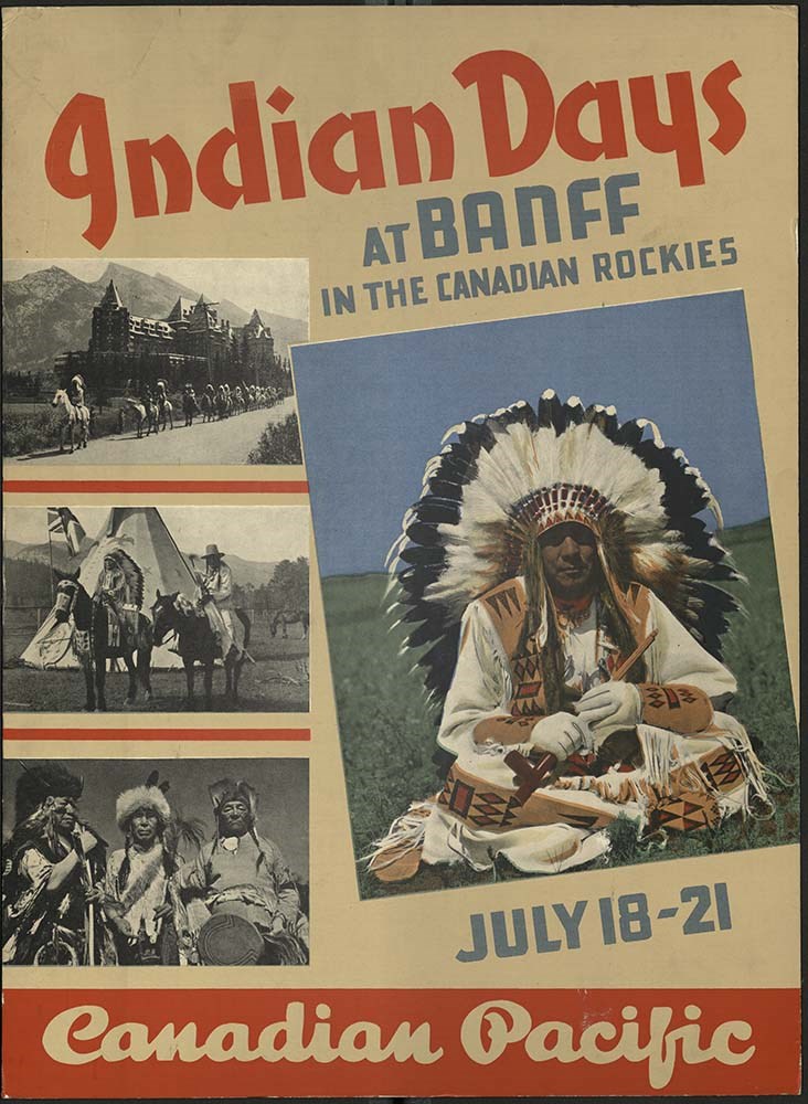
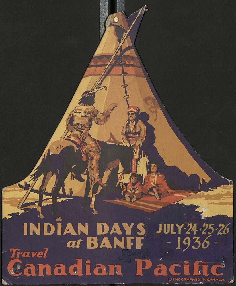
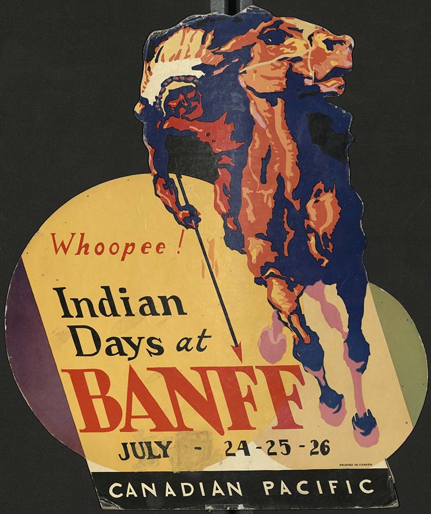
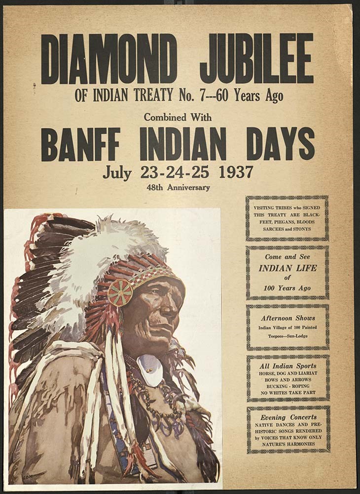
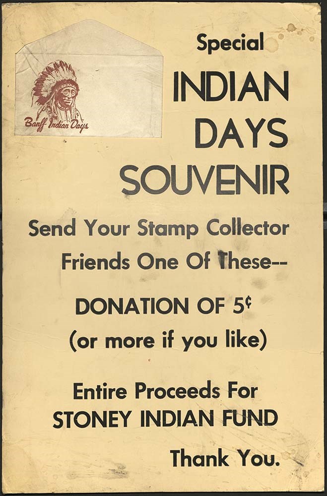
Banff Indian Days posters
https://archives.whyte.org/en/permalink/descriptions57513
- Part Of
- Luxton family fonds
- Scope & Content
- File consists of 14 colour and b&w oversized promotional posters and information boards for Banff Indian Days celebrations, promoted by Canadian Pacific. Posters largely feature identified and unidentified Indigenous people, notably Chief Spotted Eagle and Blind Eagle. Art medium includes oil pain…
- Date Range
- [ca. 1930-1950]
- 1936
- 1937
- 1949
- Reference Code
- LUX / I / D3 / 1 - 14
- Description Level
- 5 / File
- GMD
- Textual record
- Poster
- Drawing
- Published record
18 images
- Part Of
- Luxton family fonds
- Description Level
- 5 / File
- Fonds Number
- LUX
- Series
- I.D.3. Personal and professional : Organizations
- Sous-Fonds
- I. Norman Luxton sous-fonds
- Accession Number
- LUX
- Reference Code
- LUX / I / D3 / 1 - 14
- Responsibility
- Published and artwork attributed to Ernie Kehr, W.L. Kihn, G.H.W. Ashley, Crag & Canyon Press, Palenske, Canadian Pacific and Multi Color Poster
- Date Range
- [ca. 1930-1950]
- 1936
- 1937
- 1949
- Physical Description
- 14 posters : colour and b&w ; 35 x 56 cm or smaller
- Scope & Content
- File consists of 14 colour and b&w oversized promotional posters and information boards for Banff Indian Days celebrations, promoted by Canadian Pacific. Posters largely feature identified and unidentified Indigenous people, notably Chief Spotted Eagle and Blind Eagle. Art medium includes oil paint process mounted on cardboard made in Canada and distributed by Exhibits Branch Canadian Pacific, lithographic prints, and a mounted drawing attributed to Palenske. Some have annotations or stamps on the back.
- Notes
- Possibly unassociated shipping packing material addressed to Norman Luxton at the Trading Post from E.A. Kehr found in box - this has not been assigned a number. D3-10, a lithographic promotional material from 1936 has an identical design to LUX / II / F1 / 47, an Indian Days poster from 1928 Items LUX / I / D3 / 1, 2, 4, 5, 8, 9, 10, 11, 12, 14 were originally associated with LUX / I / D3a / 6, which contains brochures and a flyer from Banff Indian Days LUX / I / D3 / 8, Palenske may have potentionally used photograph LUX / I / D3a / PA-26 as reference
- Material Details
- Some posters have foldable cardboard stand at back to place upright on surface, adhesives, and perhaps mounting additives.
- Subject Access
- Activities
- Advertising
- Community events
- Banff Indian Days
- Indigenous Peoples
- Tourism
- Geographic Access
- Banff
- Alberta
- Banff National Park
- Reproduction Restrictions
- Restrictions may apply
- Title Source
- Title based on contents of file
- Processing Status
- Processed
Images


This material is presented as originally created; it may contain outdated cultural descriptions and
potentially offensive content.
Read more.
Maps of Banff and Western Canada
https://archives.whyte.org/en/permalink/descriptions54772
- Part Of
- Luxton family fonds
- Scope & Content
- File consists of 9 printed maps, b&w and col. [including zoning and topographical maps] depicting the Town of Banff and Banff National Park, the Rocky Mountains Forest Reserve, the Moose Mountain region, Medicine Hat, and the province of Alberta. File includes Trail Riders' Map of the Canadian Rock…
- Date Range
- 1912
- 1914
- 1924
- 1926
- 1932
- 1957
- [1970-1980]
- Reference Code
- LUX / II / C5 / 25
- Description Level
- 5 / File
- GMD
- Textual record
- Published record
- Map
- Part Of
- Luxton family fonds
- Description Level
- 5 / File
- Fonds Number
- LUX
- Series
- LUX / II / C : Personal
- Sous-Fonds
- LUX / II : Eleanor Luxton sous-fonds
- Sub-Series
- LUX / II / C5 : Other
- Accession Number
- LUX
- Reference Code
- LUX / II / C5 / 25
- Date Range
- 1912
- 1914
- 1924
- 1926
- 1932
- 1957
- [1970-1980]
- Physical Description
- 9 maps : b&w and col. ; 168 x 71 cm or smaller
- Scope & Content
- File consists of 9 printed maps, b&w and col. [including zoning and topographical maps] depicting the Town of Banff and Banff National Park, the Rocky Mountains Forest Reserve, the Moose Mountain region, Medicine Hat, and the province of Alberta. File includes Trail Riders' Map of the Canadian Rockies which has smaller maps of Waterton Lakes, Glacier, Revelstoke, and other national parks printed on the back. Map of Medicine Hat includes annotated storage envelope with dimensions written on the front.
- Subject Access
- Cartography
- Geography
- Land use
- Government
- Travel
- National parks and reserves
- Geographic Access
- Canada
- Alberta
- Banff
- Banff National Park
- Medicine Hat
- Rocky Mountains
- Glacier National Park
- Revelstoke
- Waterton Lakes National Park
- Reproduction Restrictions
- Restrictions may apply
- Language
- English
- Title Source
- Title based on contents of file
- Processing Status
- Processed
This material is presented as originally created; it may contain outdated cultural descriptions and
potentially offensive content.
Read more.
Sunshine Ski Area
https://archives.whyte.org/en/permalink/descriptions54780
- Part Of
- Murray Hay fonds
- Scope & Content
- File consists of 1.5 cm of textual records, 58 x 72.5 cm and 21.5 x 27.5 cm. File pertains to ski trail maps of Sunshine Ski Area created by Murray Hay. File includes two published reproductions of original trail maps in poster format made by Hay for the Husky World Downhill and Giant Slalom on Mar…
- Date Range
- ca.1985-1986
- 1986
- Reference Code
- M570 / III / B / i / 1-2
- Description Level
- 5 / File
- GMD
- Map
- Poster
- Textual record
- Published record
- Part Of
- Murray Hay fonds
- Description Level
- 5 / File
- Fonds Number
- M570 / V795
- Series
- M570 / III : Murray Hay Portfolio (published material)
- Sous-Fonds
- M570
- Sub-Series
- M570 / III / B : Alberta / i : Sunshine
- Accession Number
- 2019.41
- Reference Code
- M570 / III / B / i / 1-2
- Date Range
- ca.1985-1986
- 1986
- Physical Description
- 1.5 cm of textual records (58 x 72.5 cm and 21.5 x 27.5 cm)
- Scope & Content
- File consists of 1.5 cm of textual records, 58 x 72.5 cm and 21.5 x 27.5 cm. File pertains to ski trail maps of Sunshine Ski Area created by Murray Hay. File includes two published reproductions of original trail maps in poster format made by Hay for the Husky World Downhill and Giant Slalom on March 8-9, 1986.
- Notes
- M570 / III / B / i / 2 is oversize.
- Name Access
- Hay, Murray
- Subject Access
- Skiing
- Ski Maps
- Ski area
- Tourism
- Cartography
- Map
- Winter
- Winter sports
- Travel
- Sunshine Village
- Sunshine Ski Resort
- Sunshine area
- Sports and recreation
- Artist
- Advertising
- Geographic Access
- Banff National Park
- Alberta
- Canada
- Canadian Rocky Mountains
- Language
- English
- Related Material
- V795 / II / B / vi / 1-3
- Title Source
- Title based on contents of file
- Processing Status
- Processed
This material is presented as originally created; it may contain outdated cultural descriptions and
potentially offensive content.
Read more.
Canadian Rockies
https://archives.whyte.org/en/permalink/descriptions54817
- Part Of
- Murray Hay fonds
- Scope & Content
- File consists of 1 cm of textual records, 10 x 22 cm. File pertains to tourist maps of the Canadian Rocky Mountains created by Murray Hay. File includes a brochure of titled "Canadian Rockies Access Maps" that, when unfolded, includes several maps of the various areas that make up the Canadian Rock…
- Date Range
- ca. 1990 - 1999
- 1999
- Reference Code
- M570 / III / D / i / 2
- Description Level
- 5 / File
- GMD
- Published record
- Map
- Textual record
- Part Of
- Murray Hay fonds
- Description Level
- 5 / File
- Fonds Number
- M570 / V795
- Series
- M570 / III : Murray Hay portfolio (published material)
- Sous-Fonds
- M570
- Sub-Series
- M570 / III / D : Miscellaneous / i : Canada (general)
- Accession Number
- 2019.41
- Reference Code
- M570 / III / D / i / 2
- Date Range
- ca. 1990 - 1999
- 1999
- Physical Description
- 1 cm of textual records (10 x 22 cm)
- Scope & Content
- File consists of 1 cm of textual records, 10 x 22 cm. File pertains to tourist maps of the Canadian Rocky Mountains created by Murray Hay. File includes a brochure of titled "Canadian Rockies Access Maps" that, when unfolded, includes several maps of the various areas that make up the Canadian Rocky Mountains, like Kananaskis Country, Canmore, Banff National Park, Jasper National Park, Yoho National Park, etc.
- Name Access
- Hay, Murray
- Subject Access
- Advertising
- Artist
- Banff
- Banff National Park
- Cartography
- Communications
- Lake Louise
- Kananaskis Country
- Map
- Mountains
- Tourism
- Tourist information
- Travel
- Geographic Access
- Canada
- Canadian Rocky Mountains
- Alberta
- British Columbia
- Yoho National Park
- Jasper National Park
- Banff National Park
- Glacier National Park
- Canmore
- Banff
- Jasper
- Lake Louise
- Kananaskis
- Kananaskis Country
- Kootenay National Park
- Language
- English
- Title Source
- Title based on contents of file
- Processing Status
- Processed
This material is presented as originally created; it may contain outdated cultural descriptions and
potentially offensive content.
Read more.
Published regional and trail maps
https://archives.whyte.org/en/permalink/descriptions54847
- Scope & Content
- File consists of maps depicting the Banff townsite and nearby travel routes. Includes a trail map for Banff, Yoho and Kootenay National Parks; a road map for Banff and nearby areas [1965]; a numbered townsite map of Banff marking local hotels and attractions; and a photocopied map of a trail route …
- Date Range
- [1950-1970]
- 1965
- Reference Code
- M545 / III / 29
- Description Level
- 5 / File
- GMD
- Textual record
- Published record
- Map
- Description Level
- 5 / File
- Fonds Number
- M545 / V635
- Series
- M545 / III : Published records
- Sous-Fonds
- M545
- Accession Number
- 5939
- Reference Code
- M545 / III / 29
- Date Range
- [1950-1970]
- 1965
- Physical Description
- 0.5 cm of textual records (4 maps ; 35.5 x 21.5 cm or smaller)
- Scope & Content
- File consists of maps depicting the Banff townsite and nearby travel routes. Includes a trail map for Banff, Yoho and Kootenay National Parks; a road map for Banff and nearby areas [1965]; a numbered townsite map of Banff marking local hotels and attractions; and a photocopied map of a trail route used by the Trail Riders of the Canadian Rockies [n.d.]
- Notes
- Banff townsite map has annotation marking the location of the Trail Ride Office on Caribou St.
- Subject Access
- Travel
- Trails
- Map
- Land, settlement and immigration
- Geography
- Geographic Access
- Canada
- Alberta
- Banff
- Banff National Park
- Yoho National Park
- Kootenay National Park
- Reproduction Restrictions
- Restrictions may apply
- Language
- English
- Title Source
- Title based on contents of file
- Processing Status
- Processed
This material is presented as originally created; it may contain outdated cultural descriptions and
potentially offensive content.
Read more.
Banff National Park and Lake Louise maps
https://archives.whyte.org/en/permalink/descriptions54945
- Scope & Content
- File consists of two folded maps and a small clipping [possibly top or bottom portion from a different map or one of maps in file]. One map is of Banff National Park and one is of Lake Louise [1959]. Banff National Park map has black pencil tracings over trail section near the bottom of the map and…
- Date Range
- 1959
- [1960-1970]
- Reference Code
- M545 / V / 53
- Description Level
- 5 / File
- GMD
- Textual record
- Published record
- Map
- Description Level
- 5 / File
- Fonds Number
- M545 / V635
- Series
- M545 / V : Administrative records
- Sous-Fonds
- M545
- Accession Number
- 8235
- Reference Code
- M545 / V / 53
- Date Range
- 1959
- [1960-1970]
- Physical Description
- 0.5 cm of textual records (2 maps ; 60.5 x 57.5 and 60 x 56.5 cm)
- Scope & Content
- File consists of two folded maps and a small clipping [possibly top or bottom portion from a different map or one of maps in file]. One map is of Banff National Park and one is of Lake Louise [1959]. Banff National Park map has black pencil tracings over trail section near the bottom of the map and annotation in bottom right corner which reads "Natural Bridge". Lake Louise map produced by the Government of Canada.
- Subject Access
- Banff National Park
- Environment
- Geography
- Map
- Lake Louise
- Travel
- Government
- National parks and reserves
- Trails
- Geographic Access
- Canada
- Alberta
- Banff National Park
- Lake Louise
- Language
- English
- Conservation
- Clipping stored in mylar due to significant staining and residue from tape
- Items kept folded [not placed in mylar] due to mass production of content and minimal/no annotations
- Title Source
- Title based on contents of file
- Processing Status
- Processed
This material is presented as originally created; it may contain outdated cultural descriptions and
potentially offensive content.
Read more.
Calgary Olympic Bid 1988
https://archives.whyte.org/en/permalink/descriptions54946
- Part Of
- Murray Hay fonds
- Scope & Content
- File consists of 10 prints : col. ; 64 x 61 cm or smaller. File pertains to Murray Hay's participation in Calgary's Olympic Bid in the early 1980s. File includes a variety of different reproduced draft maps depciting Calgary and Canada Olympic Park, Banff National Park, Kananaskis, Spray Valley, et…
- Date Range
- ca.1980-ca.1981
- Reference Code
- V795 / II / B / iv / 1-2
- Description Level
- 5 / File
- GMD
- Map
- Private record
- Part Of
- Murray Hay fonds
- Description Level
- 5 / File
- Fonds Number
- M570 / V795
- Series
- V795 / II : Unpublished Material
- Sous-Fonds
- V795
- Sub-Series
- V795 / II / B : Alberta / iv : Olympic Bid
- Accession Number
- 2019.41
- Reference Code
- V795 / II / B / iv / 1-2
- GMD
- Map
- Private record
- Date Range
- ca.1980-ca.1981
- Physical Description
- 10 prints : col. ; 64 x 61 cm or smaller
- Scope & Content
- File consists of 10 prints : col. ; 64 x 61 cm or smaller. File pertains to Murray Hay's participation in Calgary's Olympic Bid in the early 1980s. File includes a variety of different reproduced draft maps depciting Calgary and Canada Olympic Park, Banff National Park, Kananaskis, Spray Valley, etc.
- Notes
- Date range is approximate. The Olympic Bid was selected in 1981.
- One print depicting the City of Calgary with the Canadian Rockies in the background has a note taped to it that reads: "A view from Calgary to Banff showing Olympic sites for 1988 winter games (proximity exaggerated."
- Name Access
- Hay, Murray
- Subject Access
- Artist
- Ski Maps
- Map
- Cartography
- Sports and recreation
- Tourism
- Winter
- Winter sports
- Olympic Games (Winter)
- Geographic Access
- Calgary
- Banff National Park
- Alberta
- Canada
- Canadian Rocky Mountains
- Canada Olympic Park
- Spray Lakes
- Spray Valley
- Bow Valley
- Kananaskis
- Bragg Creek
- Canmore
- Language
- English
- Conservation
- V795 / II / B / iv / 2 : Masking tape should be removed and alternative preservation methods should be considered at a reasonable time to do so.
- Related Material
- M570 / III / C / i / 1
- Creator
- Hay, Murray
- Title Source
- Title based on contents of file
- Processing Status
- Processed
This material is presented as originally created; it may contain outdated cultural descriptions and
potentially offensive content.
Read more.
Sunshine Village
https://archives.whyte.org/en/permalink/descriptions54991
- Part Of
- Murray Hay fonds
- Scope & Content
- File consists of 9 prints : b&w and col. ; 35 x 28 cm or smaller, 2 maps (1 base, 4 overlays) : col., annotations, on mylar ; 26 x 35 cm and 23.5 x 31.5 cm, and 1 painting : landscape ; 46 x 43 cm. File pertains to ski trail maps and landscape maps/prints of Sunshine ski area created by Murray Hay.…
- Date Range
- ca.1980-ca.1999
- Reference Code
- V795 / II / B / vi / 1-3
- Description Level
- 5 / File
- GMD
- Map
- Painting
- Private record
- Part Of
- Murray Hay fonds
- Description Level
- 5 / File
- Fonds Number
- M570 / V795
- Series
- V795 / II : Unpublished Material
- Sous-Fonds
- V795
- Sub-Series
- V795 / II / B : Alberta / vi : Sunshine Village Ski Resort
- Accession Number
- 2019.41
- Reference Code
- V795 / II / B / vi / 1-3
- Date Range
- ca.1980-ca.1999
- Physical Description
- 9 prints : b&w and col. ; 35 x 28 cm or smaller
- 2 maps (1 base, 4 overlays) : col., annotations, on mylar ; 26 x 35 cm and 23.5 x 31.5 cm
- 1 painting : landscape ; 46 x 43 cm
- Scope & Content
- File consists of 9 prints : b&w and col. ; 35 x 28 cm or smaller, 2 maps (1 base, 4 overlays) : col., annotations, on mylar ; 26 x 35 cm and 23.5 x 31.5 cm, and 1 painting : landscape ; 46 x 43 cm. File pertains to ski trail maps and landscape maps/prints of Sunshine ski area created by Murray Hay. File includes 9 reproduced draft prints (various iterations), 2 reproduced maps with overlays held together with masking tape, and 1 original painting/drawing (unfinished).
- Name Access
- Hay, Murray
- Subject Access
- Advertising
- Artist
- Ski Maps
- Ski area
- Map
- Cartography
- Sports and recreation
- Tourism
- Tourist information
- Winter
- Winter sports
- Sunshine area
- Sunshine Village
- Sunshine Ski Resort
- Geographic Access
- Sunshine
- Alberta
- Canada
- Canadian Rocky Mountains
- Banff National Park
- Language
- English
- Related Material
- M570 / III / B / i / 1-2
- Creator
- Hay, Murray
- Title Source
- Title based on contents of file
- Processing Status
- Processed
This material is presented as originally created; it may contain outdated cultural descriptions and
potentially offensive content.
Read more.
Deep Powder and Steep Rock - textual
https://archives.whyte.org/en/permalink/descriptions55082
- Part Of
- Chic Scott fonds
- Scope & Content
- Series consists of textual records, including notes, manuscripts and other related materials, pertaining to the creation of the book "Deep Powder and Steep Rock".
- Date Range
- 2009
- Reference Code
- M57 / V
- Description Level
- 3 / Series
- GMD
- Textual record
- Map
- Part Of
- Chic Scott fonds
- Description Level
- 3 / Series
- Fonds Number
- M57 / V40 / S47
- Series
- M57 / V : Deep Powder and Steep Rock
- Sous-Fonds
- M57
- Accession Number
- 2014.8295
- 2015.8559
- Reference Code
- M57 / V
- GMD
- Textual record
- Map
- Date Range
- 2009
- Physical Description
- 30 cm of textual records
- History / Biographical
- Hans Gmoser played a major role in creating Canada’s vibrant mountain community. Although known internationally as the father of heli-skiing, he was much more than that: a talented rock climber, tireless expedition leader, a mountain guide, film maker and organizer. Deep Powder and Steep Rock presents an intimate portrait of this charismatic man. Much of the story is told in Gmoser’s own words, gleaned from his diaries, expedition journals, film commentaries and personal correspondence. It is a unique tale of adventure, hard work, perseverance and ultimate success.
- Scope & Content
- Series consists of textual records, including notes, manuscripts and other related materials, pertaining to the creation of the book "Deep Powder and Steep Rock".
- Notes
- Series consists of five sub-series: M57 / V / A: Research files M57 / V / B: Maps M57 / V / C: Interviews M57 / V / D: Photograph notes M57 / V / E: Draft Manuscript
- Name Access
- Scott, Chic
- Gmoser, Hans
- Subject Access
- Biography
- Personal and Professional Life
- Publication
- Research
- Geography
- Map
- Mountaineers
- Mountaineering
- Skiing
- Sports
- Recreation
- Winter sports
- Canadian Mountain Holidays
- Helicopter skiing
- Tourism
- Climbing
- Geographic Access
- Canada
- Alberta
- Banff
- Banff National Park
- Canadian Rocky Mountains
- Language
- English
- Related Material
- S47 / V
- V40 / V
- Biographical Source Notes
- http://chicscott.com/books.htm
- Title Source
- Title based on contents of file
- Processing Status
- Processed
This material is presented as originally created; it may contain outdated cultural descriptions and
potentially offensive content.
Read more.
Banff National Park (general)
https://archives.whyte.org/en/permalink/descriptions55338
- Part Of
- Murray Hay fonds
- Scope & Content
- File consists of 4 prings : col. 35.1 x 24.8 cm or smaller and 4 maps (2 paper, 2 overlays) : col., on mylar ; 60.4 x 30. cm or smaller. File pertains to aerial views of Banff National Park, showing the towns of Banff and Lake Louise, ski hills (Norqay Ski Hill, Sunshine Village, and Lake Louise Sk…
- Date Range
- ca.1976-ca.2000
- Reference Code
- V795 / II / B / v / 1-2
- Description Level
- 5 / File
- GMD
- Map
- Private record
- Part Of
- Murray Hay fonds
- Description Level
- 5 / File
- Fonds Number
- M570 / V795
- Series
- V795 / II : Unpublished Material
- Sous-Fonds
- V795
- Sub-Series
- V795 / II / B : Alberta / v : Banff National Park
- Accession Number
- 2019.41
- Reference Code
- V795 / II / B / v / 1-2
- GMD
- Map
- Private record
- Date Range
- ca.1976-ca.2000
- Physical Description
- 4 prints : col. 35.1 x 24.8 cm or smaller
- 4 maps (2 paper, 2 overlays) : col., annotations, on mylar ; 60.4 x 30. cm or smaller
- Scope & Content
- File consists of 4 prings : col. 35.1 x 24.8 cm or smaller and 4 maps (2 paper, 2 overlays) : col., on mylar ; 60.4 x 30. cm or smaller. File pertains to aerial views of Banff National Park, showing the towns of Banff and Lake Louise, ski hills (Norqay Ski Hill, Sunshine Village, and Lake Louise Ski Resort), as well as other georgraphic features. The mylar overlays contain various amounts of detail and annotations - one consists of a dark red sheet overlayed with place names in negative.
- Notes
- Items not in oversize stored in downstairs vault.
- Name Access
- Hay, Murray
- Subject Access
- Advertising
- Artist
- Ski Maps
- Map
- Cartography
- Sports and recreation
- Tourism
- Tourist information
- Winter
- Winter sports
- Ski area
- Sunshine Village
- Norquay Ski Hill
- Lake Louise Ski Area
- Geographic Access
- Banff
- Lake Louise
- Banff National Park
- Alberta
- Canada
- Canadian Rocky Mountains
- Language
- English
- Creator
- Hay, Murray
- Title Source
- Title based on contents of file
- Processing Status
- Processed
This material is presented as originally created; it may contain outdated cultural descriptions and
potentially offensive content.
Read more.
Kananaskis and Spray Lakes
https://archives.whyte.org/en/permalink/descriptions55339
- Part Of
- Murray Hay fonds
- Scope & Content
- File consists of 2 original paintings : landscape (2 base, 2 overlays) ; 100 x 71.2 cm or smaller (one unfinished) - the complete painting has tracing paper overlay with annotations written in pencil (second overlay also tracing paper with annotations in ink, stored seperately). Also includes 1 map…
- Date Range
- [ca.1980-2000]
- Reference Code
- V795 / II / B / iii / 1
- Description Level
- 5 / File
- GMD
- Map
- Private record
- Part Of
- Murray Hay fonds
- Description Level
- 5 / File
- Fonds Number
- M570 / V795
- Series
- V795 / II : Unpublished Material
- Sous-Fonds
- V795
- Sub-Series
- V795 / II / B : Alberta / iii : Kananaskis
- Accession Number
- 2019.41
- Reference Code
- V795 / II / B / iii / 1
- GMD
- Map
- Private record
- Date Range
- [ca.1980-2000]
- Physical Description
- 2 paintings : landscape (2 base, 2 overlays) ; 100 x 71.2 cm or smaller
- 1 map (1 base, 1 overlay) : col., annotations, on mylar ; 101 x 70.1 cm
- 2 prints : col., annotations ; 35.5 x 27.8 cm
- Scope & Content
- File consists of 2 original paintings : landscape (2 base, 2 overlays) ; 100 x 71.2 cm or smaller (one unfinished) - the complete painting has tracing paper overlay with annotations written in pencil (second overlay also tracing paper with annotations in ink, stored seperately). Also includes 1 map (1 base, 1 overlay) : col., annotations, on mylar ; 101 x 70.1 cm of the Kananaskis/Canmore area and 2 prints : col., annotations ; 35.5 x 27.8 cm of the same area.
- Notes
- Prints have two different titles associated with them: "Portion of Kananaskis, Bow Valley, Spray Lake Area (cloudy portion is for story area)" and "Kanasakis Park, Mount Allen (Nakiska) Ski Area, Fortress Mtn Ski Area & Banff East Entrance (cloudy area for story line)." Prints are connected to the map.
- Name Access
- Hay, Murray
- Subject Access
- Artist
- Ski Maps
- Map
- Cartography
- Sports and recreation
- Tourism
- Winter
- Winter sports
- Geographic Access
- Banff National Park
- Alberta
- Canada
- Spray Lakes
- Spray Valley
- Bow Valley
- Kananaskis
- Canmore
- Language
- English
- Conservation
- Masking tape should be removed
- Creator
- Hay, Murray
- Title Source
- Title based on contents of file
- Processing Status
- Processed
This material is presented as originally created; it may contain outdated cultural descriptions and
potentially offensive content.
Read more.