Narrow Results By
Jon Whelan fonds
https://archives.whyte.org/en/permalink/descriptions57454
- Part Of
- Jon Whelan fonds
- Scope & Content
- Fonds consists of research materials, publications, ephemera, and other materials collected by Jon Whelan. Fonds includes three Canadian Pacific bell boy log books, 1970-1980; five bound scrapbooks with collected newspaper clippings, ca.1880-1890; and collected advertisements and articles pertainin…
- Date Range
- [1880-2022]
- Reference Code
- M595 / V818
- Description Level
- 1 / Fonds
- GMD
- Textual record
- Photograph
- Newspaper clipping
- Published record
- Scrapbook
- Album
- Part Of
- Jon Whelan fonds
- Description Level
- 1 / Fonds
- Fonds Number
- M595
- V818
- Sous-Fonds
- M595
- V818
- Accession Number
- 2022.39
- Reference Code
- M595 / V818
- Date Range
- [1880-2022]
- Physical Description
- 3 bankers boxes
- History / Biographical
- Jon Whelan (1952-2022) was a researcher, historian, and collector based in Banff, Alberta. Jon had a special interest in topics related to Banff National Park and Canadian Pacific Railway Company. Jon conducted independent research, as well as research for various authors and historians, from the 1980s onwards. Jon was also an active participant in municipal politics in Banff. "For most of Jon’s life, he was engaged in community affairs and fearless in voicing an opinion. He was successful in raising public awareness and his tenacity achieved a personal goal, which was to initiate the use of video for regular Town of Banff council meetings. He dedicated himself to the concerns of Banff residents." -Barry Kelly, Rocky Mountain Outlook, July 30, 2022
- Scope & Content
- Fonds consists of research materials, publications, ephemera, and other materials collected by Jon Whelan. Fonds includes three Canadian Pacific bell boy log books, 1970-1980; five bound scrapbooks with collected newspaper clippings, ca.1880-1890; and collected advertisements and articles pertaining to Canadian Pacific, Banff, travel and tourism within Canada, and related subjects.
- Name Access
- Whelan, Jon
- Subject Access
- Research
- Chateau Lake Louise
- Canadian Pacific Railway
- Canadian Pacific Railway Company
- Tourism
- Travel
- Recreation
- Publication
- Newspaper
- History
- Community events
- Reproduction Restrictions
- restrictions may apply
- Language
- English
- Title Source
- Title based on contents of fonds
- Processing Status
- Unprocessed
This material is presented as originally created; it may contain outdated cultural descriptions and
potentially offensive content.
Read more.
Ben Gadd fonds
https://archives.whyte.org/en/permalink/descriptions55758
- Part Of
- Ben Gadd fonds
- Scope & Content
- Fonds consists of materials pertaining to Ben Gadd's personal life and career as an environmental researcher, educator, interpretive guide, publisher, public speaker and author, ca.1956-2018. Fonds includes maps, research materials, publication notes/drafts, correspondence, contracts, photographs, …
- Date Range
- 1956-2018
- Reference Code
- M590 / V810 / S61
- Description Level
- 1 / Fonds
- GMD
- Digital image
- Drawing
- Negative
- Newspaper clipping
- Photograph
- Photograph print
- Postcard
- Published record
- Textual record
- Video
- Transparency
- Part Of
- Ben Gadd fonds
- Description Level
- 1 / Fonds
- Fonds Number
- M590
- V810
- Sous-Fonds
- M590
- V810
- Accession Number
- 2021.20
- 2024.01
- Reference Code
- M590 / V810 / S61
- GMD
- Digital image
- Drawing
- Negative
- Newspaper clipping
- Photograph
- Photograph print
- Postcard
- Published record
- Textual record
- Video
- Transparency
- Date Range
- 1956-2018
- Physical Description
- ca. 7.9 metres of textual records -- ca. 274 maps -- 29 VHS tapes -- ca.15 discs with digital files -- 21 cassettes -- photographs -- oversized materials -- USB stick with 15 sldeshows
- History / Biographical
- Ben Gadd (1946-) is a retired naturalist, guide, geologist, instructor, freelance writer and award-winning author based in the Canadian Rockies. Ben was born in Colorado Springs, Colorado in 1946. He met his wife, Cia (Langdon) Gadd at Colorado College in 1965, and the couple married four weeks later. Ben and Cia had two sons, Will and Toby. Ben and his family relocated to Jasper in the late 1960s. Ben later attended the University of Lethbridge and graduated with a Bachelor's degree in Earth Science in 1972. Between 1976 and 1980, Ben taught classes at Mount Royal College and the Southern Alberta Institute of Technology; he later taught additional classes at Grant MacEwan College and Lakeland College. From 1981, Ben also worked as a seasonal naturalist/guide for Parks Canada. Ben left Parks Canada in 1985 to start an independent naturalist guiding business with Cia based in Jasper and other parts of the Canadian Rockies, which the couple continued to operate for over two decades. Ben published his best-known work, "Handbook of the Canadian Rockies", through his publishing company Corax Press in 1986. The second edition of "Handbook of the Canadian Rockies" received multiple awards after its release in 1995. Ben's fiction book, "Raven's End" won the title of Best Canadian Rockies Book at the Banff Mountain Film and Book Festival in 2001 and became a Canadian bestseller. Overall, Ben has authored or co-authored 11 books and received nearly one dozen awards for his achievements as a writer, researcher and guide. Ben continued to lead guided hikes and school programs until his retirement in 2016.
- Scope & Content
- Fonds consists of materials pertaining to Ben Gadd's personal life and career as an environmental researcher, educator, interpretive guide, publisher, public speaker and author, ca.1956-2018. Fonds includes maps, research materials, publication notes/drafts, correspondence, contracts, photographs, video and sound recordings, and other related material. Materials donated in 2024 include one USB stick containing
- Notes
- Ben Gadd fonds arrangement: Series I : Personal records - Subseries A : Travel guides and maps - Subseries B : Education and early writings - Subseries C : Personal interest files - Subseries D : Other personal and collected Series II : Research and publication records - Subseries A : Handbook of the Canadian Rockies - Subseries B : Other publications Series III : Professional records - Subseries A : Parks Canada Records - Subseries B : Interpretive guiding - Subseries C : Teaching records - Subseries D : Other contracts and projects Series IV : Legal and financial records - Subseries A : Legal records - Subseries B : Financial records
- Subject Access
- Education
- Research
- Publication
- Environment
- Geology
- Tourism
- Family and personal life
- Personal and Professional Life
- Academics
- Guiding
- Guides
- Businesses
- Finances
- Conservation
- Wildlife
- Natural history
- Sports and recreation
- Geographic Access
- Canada
- Alberta
- Jasper National Park
- Banff National Park
- Yoho National Park
- Kootenay National Park
- Lethbridge
- United States of America
- Colorado
- Canadian Rocky Mountains
- Reproduction Restrictions
- Copyright restrictions apply
- Language
- English
- French
- Dutch
- Title Source
- Title based on contents of fonds
- Processing Status
- Processed / Unprocessed
This material is presented as originally created; it may contain outdated cultural descriptions and
potentially offensive content.
Read more.
Friends, travel
https://archives.whyte.org/en/permalink/descriptions56319
- Part Of
- Ben Gadd fonds
- Scope & Content
- File consists of photographs taken or collected by Ben Gadd between 1983 and ca.1990. Images pertain to unnamed friends at Maligne Canyon; and views of Wisconsin, South Dakota and other regions of the United States.
- Date Range
- 1983
- [1985-1990]
- Reference Code
- V810 / I / D / PA - 1 to 12
- Description Level
- 5 / File
- GMD
- Photograph
- Part Of
- Ben Gadd fonds
- Description Level
- 5 / File
- Fonds Number
- M590
- V810
- S61
- Series
- V810 / I : Personal records
- Sous-Fonds
- V810
- Sub-Series
- V810 / I / D : Other personal and collected
- Accession Number
- 2021.20
- Reference Code
- V810 / I / D / PA - 1 to 12
- GMD
- Photograph
- Date Range
- 1983
- [1985-1990]
- Physical Description
- 12 photographs : col. prints ; 10 x 15 cm or smaller
- Scope & Content
- File consists of photographs taken or collected by Ben Gadd between 1983 and ca.1990. Images pertain to unnamed friends at Maligne Canyon; and views of Wisconsin, South Dakota and other regions of the United States.
- Notes
- Some photographs in file are annotated on back
- Name Access
- Gadd, Ben
- Subject Access
- Travel
- Tourism
- Hiking
- Recreation
- Environment
- Family and personal life
- Geographic Access
- Canada
- Alberta
- Maligne Canyon
- United States of America
- Wisconsin
- South Dakota
- Language
- English
- Category
- Family and personal life
- Environment
- Sports, recreation and leisure
- Exploration, discovery and travel
- Title Source
- Title based on contents of file
- Processing Status
- Processed
This material is presented as originally created; it may contain outdated cultural descriptions and
potentially offensive content.
Read more.
West Central Alberta interpretive signs
https://archives.whyte.org/en/permalink/descriptions56327
- Part Of
- Ben Gadd fonds
- Scope & Content
- File consists of photographs depicting landscape views of west central Alberta, which were used by Ben Gadd for the production of interpretive signs. File includes several prints which were taped together to form one panoramic view.
- Date Range
- [ca.1990-1995]
- Reference Code
- V810 / III / D / PA - 19 to 38
- Description Level
- 5 / File
- GMD
- Photograph
- Part Of
- Ben Gadd fonds
- Description Level
- 5 / File
- Fonds Number
- M590
- V810
- S61
- Series
- V810 / III : Professional records
- Sous-Fonds
- V810
- Sub-Series
- V810 / III / D : Other contracts and projects
- Accession Number
- 2021.20
- Reference Code
- V810 / III / D / PA - 19 to 38
- GMD
- Photograph
- Responsibility
- Produced by Ben Gadd
- Date Range
- [ca.1990-1995]
- Physical Description
- 20 photographs : col. prints ; 29.5 x 13.5 cm and 10 x 15 cm
- Scope & Content
- File consists of photographs depicting landscape views of west central Alberta, which were used by Ben Gadd for the production of interpretive signs. File includes several prints which were taped together to form one panoramic view.
- Name Access
- Gadd, Ben
- Subject Access
- Environment
- Landscape
- Guiding
- Tourist information
- Geographic Access
- Canada
- Alberta
- Reproduction Restrictions
- Restrictions may apply
- Language
- English
- Related Material
- V810/III/D/NA-7 to 13
- Category
- Environment
- Tourism
- Title Source
- Title based on contents of file
- Processing Status
- Processed
This material is presented as originally created; it may contain outdated cultural descriptions and
potentially offensive content.
Read more.
Kinney Lake and Berg Lake trail signs
https://archives.whyte.org/en/permalink/descriptions56328
- Part Of
- Ben Gadd fonds
- Scope & Content
- File consists of photographs depicting landscape and mountain views, plant species, and interpretive trail signs near Kinney Lake and Berg Lake.
- Date Range
- 1996
- Reference Code
- V810 / III / D / PA - 39 to 85
- Description Level
- 5 / File
- GMD
- Photograph
- Part Of
- Ben Gadd fonds
- Description Level
- 5 / File
- Fonds Number
- M590
- V810
- S61
- Series
- V810 / III : Professional records
- Sous-Fonds
- V810
- Sub-Series
- V810 / III / D : Other contracts and projects
- Accession Number
- 2021.20
- Reference Code
- V810 / III / D / PA - 39 to 85
- GMD
- Photograph
- Responsibility
- Produced by Ben Gadd
- Date Range
- 1996
- Physical Description
- 47 photographs : col. prints ; 10 x 15 cm
- Scope & Content
- File consists of photographs depicting landscape and mountain views, plant species, and interpretive trail signs near Kinney Lake and Berg Lake.
- Name Access
- Gadd, Ben
- Subject Access
- Environment
- Landscape
- Guiding
- Tourist information
- Trails
- Geographic Access
- Canada
- Alberta
- Reproduction Restrictions
- Restrictions may apply
- Language
- English
- Related Material
- V810/III/D/NA-14 to 26
- Category
- Environment
- Tourism
- Title Source
- Title based on contents of file
- Processing Status
- Processed
This material is presented as originally created; it may contain outdated cultural descriptions and
potentially offensive content.
Read more.
Kinney Lake and Berg Lake trail signs
https://archives.whyte.org/en/permalink/descriptions56329
- Part Of
- Ben Gadd fonds
- Scope & Content
- File consists of photographs depicting landscape and mountain views, plant species, and interpretive trail signs near Kinney Lake and Berg Lake.
- Date Range
- 1996
- Reference Code
- V810 / III / D / NA - 14 to 29
- Description Level
- 5 / File
- GMD
- Photograph
- Part Of
- Ben Gadd fonds
- Description Level
- 5 / File
- Fonds Number
- M590
- V810
- S61
- Series
- V810 / III : Professional records
- Sous-Fonds
- V810
- Sub-Series
- V810 / III / D : Other contracts and projects
- Accession Number
- 2021.20
- Reference Code
- V810 / III / D / NA - 14 to 29
- GMD
- Photograph
- Responsibility
- Produced by Ben Gadd
- Date Range
- 1996
- Physical Description
- 62 photographs : 16 col. negative film strips ; 35mm
- Scope & Content
- File consists of photographs depicting landscape and mountain views, plant species, and interpretive trail signs near Kinney Lake and Berg Lake.
- Name Access
- Gadd, Ben
- Subject Access
- Environment
- Landscape
- Guiding
- Tourist information
- Trails
- Geographic Access
- Canada
- Alberta
- Reproduction Restrictions
- Restrictions may apply
- Language
- English
- Related Material
- V810/III/D/PA-39 to 85
- Category
- Environment
- Tourism
- Title Source
- Title based on contents of file
- Processing Status
- Processed
This material is presented as originally created; it may contain outdated cultural descriptions and
potentially offensive content.
Read more.
Icefield Centre Redevelopment
https://archives.whyte.org/en/permalink/descriptions56393
- Part Of
- Ben Gadd fonds
- Scope & Content
- File consists of photographs depicting interior and exterior views of the Columbia Icefield Discovery Centre in Jasper National Park, following renovations to the property in 1998.
- Date Range
- 1998
- Reference Code
- V810 / I / C / PA - 27 to 56
- Description Level
- 5 / File
- GMD
- Photograph
- Part Of
- Ben Gadd fonds
- Description Level
- 5 / File
- Fonds Number
- M590
- V810
- S61
- Series
- V810 / I : Personal records
- Sous-Fonds
- V810
- Sub-Series
- V810 / I / C : Personal interest files
- Accession Number
- 2021.20
- Reference Code
- V810 / I / C / PA - 27 to 56
- GMD
- Photograph
- Responsibility
- Produced by Ben Gadd
- Date Range
- 1998
- Physical Description
- 30 photographs : col. prints ; 15 x 10 cm
- Scope & Content
- File consists of photographs depicting interior and exterior views of the Columbia Icefield Discovery Centre in Jasper National Park, following renovations to the property in 1998.
- Material Details
- Original photo envelope annotated in black marker: "Icefield Ctr. 1998 Photos by Ben with Jill Seaton's camera"
- Name Access
- Gadd, Ben
- Seaton, Jill
- Subject Access
- Construction
- Landscape
- Tourism
- Tourist information
- Geographic Access
- Canada
- Alberta
- Jasper National Park
- Language
- English
- Related Material
- V810/I/C/NA-10 to 17
- Category
- Tourism
- Title Source
- Original title used
- Processing Status
- Processed
This material is presented as originally created; it may contain outdated cultural descriptions and
potentially offensive content.
Read more.
- Part Of
- Ben Gadd fonds
- Scope & Content
- File consists of photographs taken by Ben Gadd during a trip to Jackman Flats Provincial Park in 1997. Images depict unidentified individuals posing next to interpretive signs; hiking trails; a truck driving through sand; and measurements of a geological artifact.
- Date Range
- 1997
- Reference Code
- V810 / III / D / PA - 128 to 172
- Description Level
- 5 / File
- GMD
- Photograph
- Part Of
- Ben Gadd fonds
- Description Level
- 5 / File
- Fonds Number
- M590
- V810
- S61
- Series
- V810 / III : Professional records
- Sous-Fonds
- V810
- Sub-Series
- V810 / III / D : Other contracts and projects
- Accession Number
- 2021.20
- Reference Code
- V810 / III / D / PA - 128 to 172
- GMD
- Photograph
- Responsibility
- Produced by Ben Gadd
- Date Range
- 1997
- Physical Description
- 45 photographs : col. prints ; 10 x 15 cm
- Scope & Content
- File consists of photographs taken by Ben Gadd during a trip to Jackman Flats Provincial Park in 1997. Images depict unidentified individuals posing next to interpretive signs; hiking trails; a truck driving through sand; and measurements of a geological artifact.
- Name Access
- Gadd, Ben
- Subject Access
- Tourism
- Tourist information
- Hiking
- Recreation
- Trails
- Provincial parks and reserves
- Family and personal life
- Geology
- Research
- Geographic Access
- Canada
- British Columbia
- Jackman Flats Provincial Park
- Language
- N/A
- Related Material
- V810/III/D/NA-52 to 53
- Title Source
- Original title used
- Processing Status
- Processed
This material is presented as originally created; it may contain outdated cultural descriptions and
potentially offensive content.
Read more.
Pembina River Provincial Park
https://archives.whyte.org/en/permalink/descriptions56397
- Part Of
- Ben Gadd fonds
- Scope & Content
- File consists of photographs taken by Ben Gadd during a trip to Pembina River Provincial Park, including winter views of hiking trails and forested areas.
- Date Range
- 1997
- Reference Code
- V810 / III / D / PA - 173 to 180
- Description Level
- 5 / File
- GMD
- Photograph
- Part Of
- Ben Gadd fonds
- Description Level
- 5 / File
- Fonds Number
- M590
- V810
- S61
- Series
- V810 / III : Professional records
- Sous-Fonds
- V810
- Sub-Series
- V810 / III / D : Other contracts and projects
- Accession Number
- 2021.20
- Reference Code
- V810 / III / D / PA - 173 to 180
- GMD
- Photograph
- Responsibility
- Produced by Ben Gadd
- Date Range
- 1997
- Physical Description
- 8 photographs : col. prints ; 10 x 15 cm
- Scope & Content
- File consists of photographs taken by Ben Gadd during a trip to Pembina River Provincial Park, including winter views of hiking trails and forested areas.
- Name Access
- Gadd, Ben
- Subject Access
- Tourism
- Tourist information
- Hiking
- Recreation
- Trails
- Provincial parks and reserves
- Geographic Access
- Canada
- British Columbia
- Pembina River Provincial Park
- Language
- N/A
- Category
- Tourism
- Sports, recreation and leisure
- Title Source
- Original title used
- Processing Status
- Processed
This material is presented as originally created; it may contain outdated cultural descriptions and
potentially offensive content.
Read more.
- Part Of
- Ben Gadd fonds
- Scope & Content
- File consists of photographs depicting trails and interpretive signs in William A. Switzer Provincial Park. Ben Gadd worked as a consultant for the Government of Alberta in the production of updated interpretive signs in William A. Switzer Provincial Park between 1995 and 1996.
- Date Range
- [ca.1995]
- Reference Code
- V810 / III / D / PA - 181 to 215
- Description Level
- 5 / File
- GMD
- Photograph
- Part Of
- Ben Gadd fonds
- Description Level
- 5 / File
- Fonds Number
- M590
- V810
- S61
- Series
- V810 / III : Professional records
- Sous-Fonds
- V810
- Sub-Series
- V810 / III / D : Other contracts and projects
- Accession Number
- 2021.20
- Reference Code
- V810 / III / D / PA - 181 to 215
- GMD
- Photograph
- Responsibility
- Produced by Ben Gadd
- Date Range
- [ca.1995]
- Physical Description
- 35 photographs : col. prints ; 28 x 20 cm and 15 x 10 cm
- Scope & Content
- File consists of photographs depicting trails and interpretive signs in William A. Switzer Provincial Park. Ben Gadd worked as a consultant for the Government of Alberta in the production of updated interpretive signs in William A. Switzer Provincial Park between 1995 and 1996.
- Name Access
- Gadd, Ben
- Subject Access
- Guides
- Guiding
- Provincial parks and reserves
- Government
- Recreation
- Hiking
- Environment
- Tourist information
- Geographic Access
- Canada
- Alberta
- William A. Switzer Provincial Park
- Language
- English
- Related Material
- M590/III/D/48 to 52
- V810/III/D/NA-54 to 75
- Title Source
- Original title used
- Processing Status
- Processed
This material is presented as originally created; it may contain outdated cultural descriptions and
potentially offensive content.
Read more.
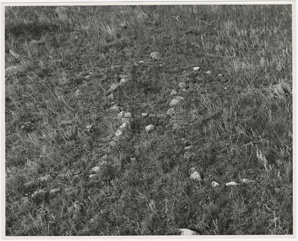
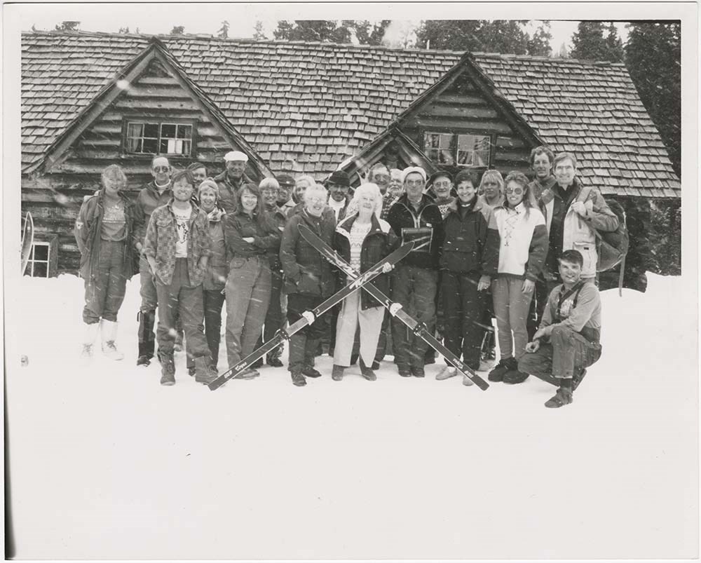
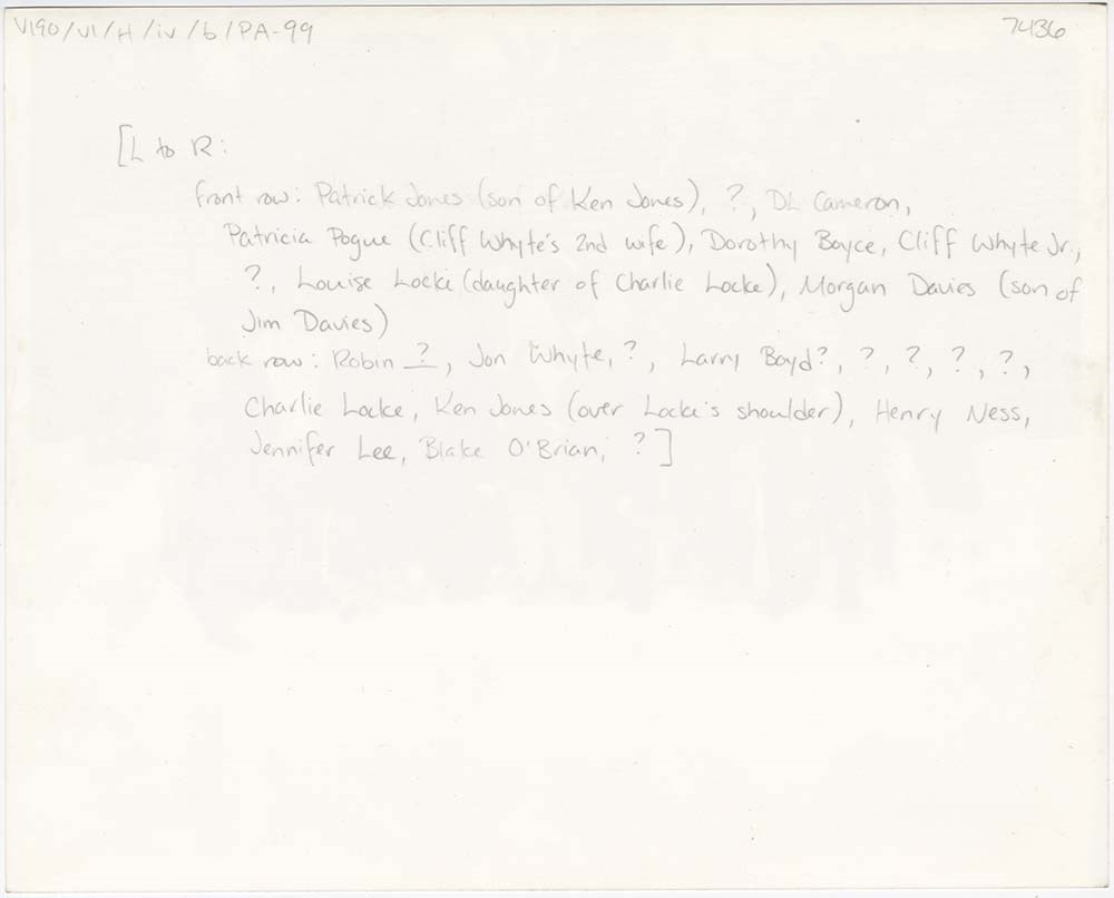
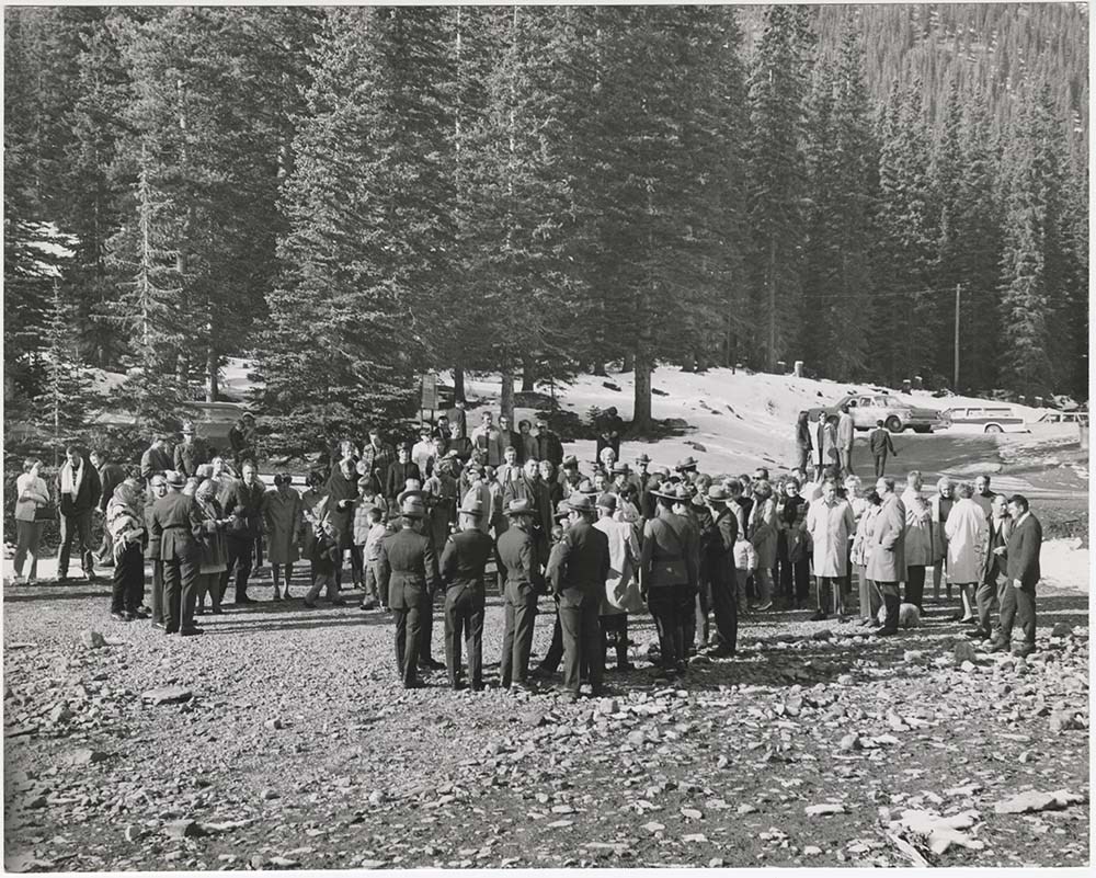
History Photos
https://archives.whyte.org/en/permalink/descriptions56901
- Part Of
- Bruno Engler fonds
- Scope & Content
- File pertains to 120 b&w prints of various historical topics, some photos taken by Bruno Engler, others collected [presumably] by him. Includes various Canadian Pacific Railway events, community events and celebrations, Skoki Lodge's 60th anniversary, the Norquay Ski Hill rope-tow, the 1968 Winter …
- Date Range
- [ca. 1886-1993]
- Reference Code
- V190 / VI / H / iv / b / PA - 01 to PA - 120
- Description Level
- 5 / File
- GMD
- Photograph
11 images
- Part Of
- Bruno Engler fonds
- Description Level
- 5 / File
- Fonds Number
- M323 / S40 / V190
- Series
- VI : Retained file, H : Alphabetical order
- Sous-Fonds
- V190
- Sub-Series
- iv : History, b : Photos
- Accession Number
- 7436
- Reference Code
- V190 / VI / H / iv / b / PA - 01 to PA - 120
- GMD
- Photograph
- Date Range
- [ca. 1886-1993]
- Physical Description
- 120 photographs : b&w ; 25.2 x 20.2 cm or smaller
- History / Biographical
- See fonds level description
- Scope & Content
- File pertains to 120 b&w prints of various historical topics, some photos taken by Bruno Engler, others collected [presumably] by him. Includes various Canadian Pacific Railway events, community events and celebrations, Skoki Lodge's 60th anniversary, the Norquay Ski Hill rope-tow, the 1968 Winter Olympics bid, Princess Margarite's [sic] visit in 1958, the Cosmic Ray Observatory operations, a Kiwanis Club event, ranching and ranch lands, portraits, and more.
- Name Access
- Perren, Walter
- Whyte, Catharine
- Whyte, Jon
- White, Cliff Jr.
- Locke, Charlie
- Jones, Ken
- Rungius, Carl
- Luxton, Eleanor
- Subject Access
- Aerial photography
- Animals
- Banff townsite
- Banff Upper Hot Springs
- Buildings and facilities
- Cave and Basin
- Centennial
- Ceremony
- Chairlifts and gondolas
- Climbing
- Community events
- Construction
- Dogs
- Entertainment
- Festival
- Helicopters
- Military
- Mount Norquay Chairlift
- Mount Norquay Ski Area
- Mountains
- Parades
- Parks Canada
- Parks Canada Warden
- Portrait
- Public events
- Roads
- Roger's Pass
- Royal tours
- Royal Visit
- Scenery
- Tourism
- Trains
- Travel
- Winter
- Winter Carnival
- Winter sports
- Geographic Access
- Banff
- Lake Louise
- Banff National Park
- Alberta
- Language
- English
- Related Material
- V190 / VI / H / iv / b / NA - 01 to NA - 04 V190 / VI / H / iv / b / NS - 01 to NS - 02
- Creator
- Engler, Bruno
- Title Source
- Original title kept
- Processing Status
- Processed
Images


This material is presented as originally created; it may contain outdated cultural descriptions and
potentially offensive content.
Read more.
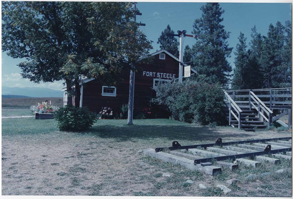
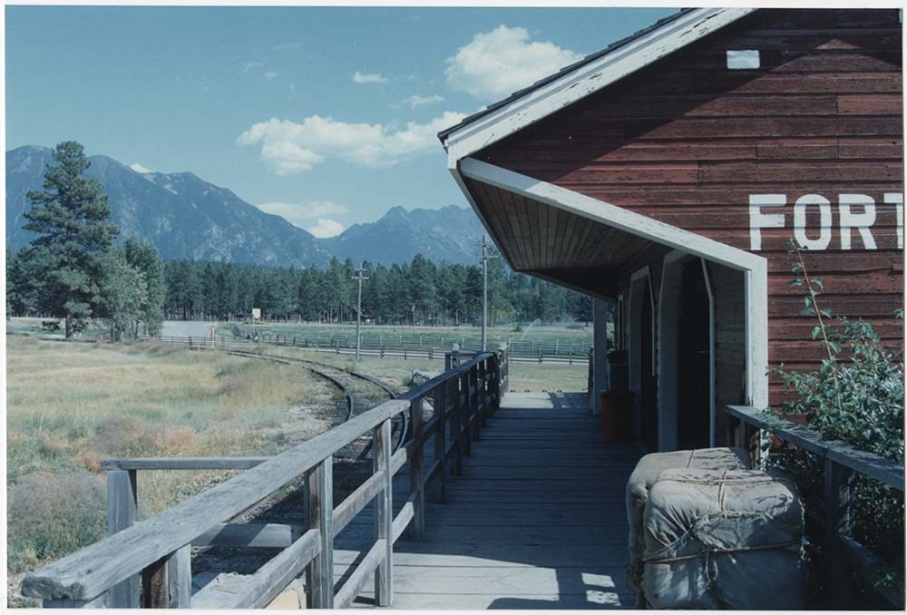
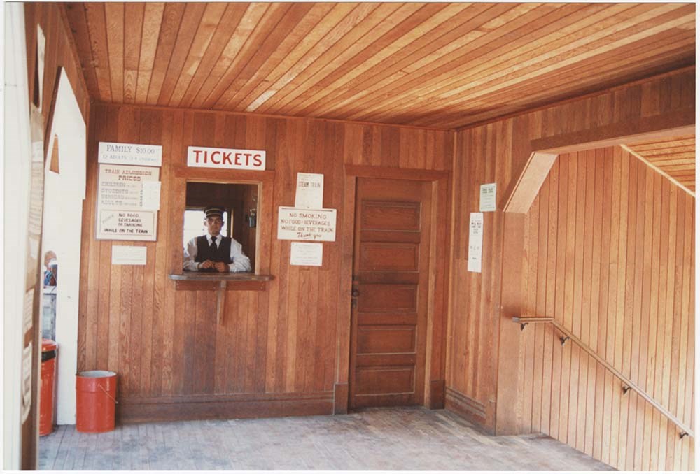
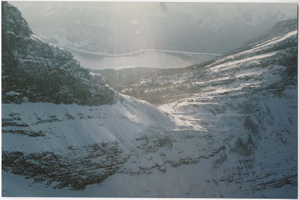
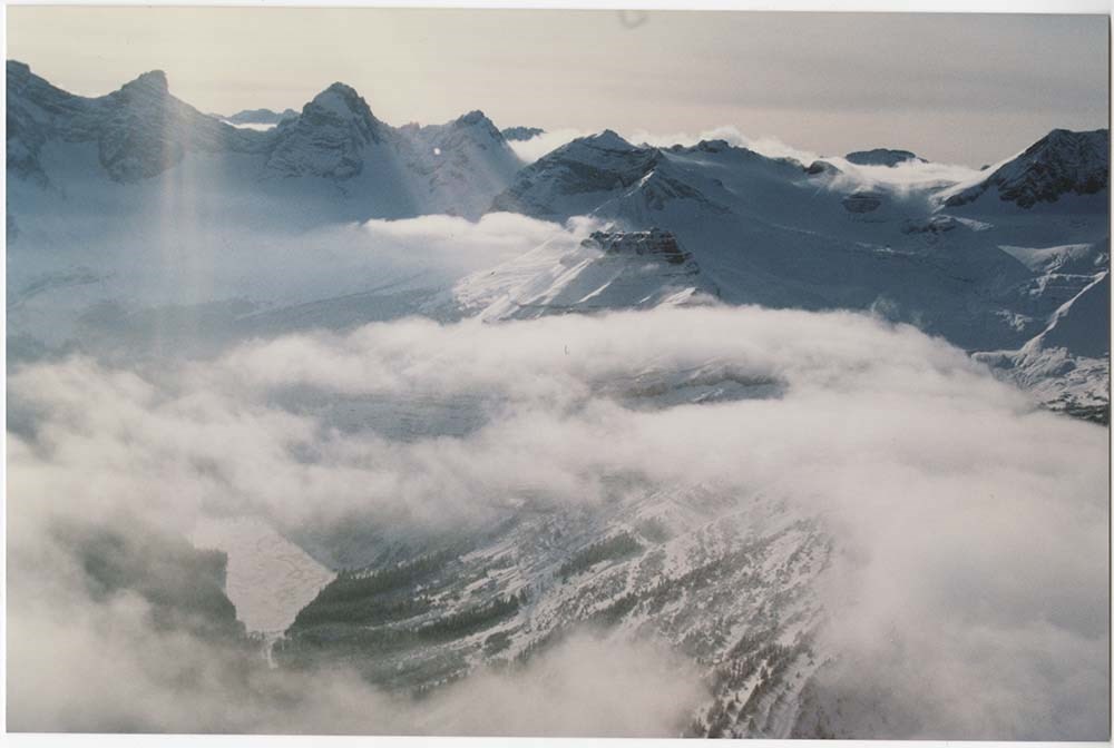
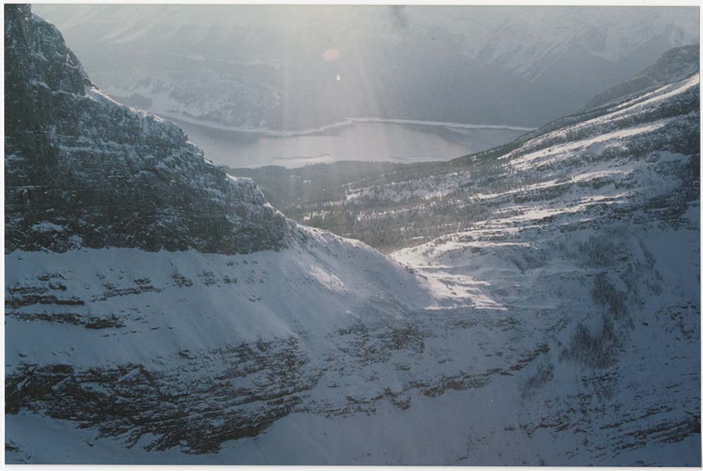
Location & Scenic [2/5]
https://archives.whyte.org/en/permalink/descriptions57136
- Part Of
- Bruno Engler fonds
- Scope & Content
- File pertains to 107 colour prints of various locations. Includes Fort Steele Locations [taken in 1991 at the same site as a 1952 shoot], wildlife, the interiors of several log houses [mostly fireplaces], the Badlands and Milk River, and various parts of Kananaskis, including Haig Glacier and Wind …
- Date Range
- 1988-1992
- Reference Code
- V190 / VI / L / v / PA - 52 to PA - 159
- Description Level
- 5 / File
- GMD
- Photograph
12 images
- Part Of
- Bruno Engler fonds
- Description Level
- 5 / File
- Fonds Number
- M323 / S40 / V190
- Series
- VI : Retained file, L : Alphabetical order
- Sous-Fonds
- V190
- Sub-Series
- v : Location & Scenic: Cliffhanger, Imax, etc
- Accession Number
- 7436
- Reference Code
- V190 / VI / L / v / PA - 52 to PA - 159
- GMD
- Photograph
- Date Range
- 1988-1992
- Physical Description
- 107 photographs : col. ; 15.2 x 10.1 cm
- History / Biographical
- See fonds level description
- Scope & Content
- File pertains to 107 colour prints of various locations. Includes Fort Steele Locations [taken in 1991 at the same site as a 1952 shoot], wildlife, the interiors of several log houses [mostly fireplaces], the Badlands and Milk River, and various parts of Kananaskis, including Haig Glacier and Wind Pass, taken from the air in 1991.
- Subject Access
- Animals
- Automobiles
- Badlands
- Buildings
- Cabins
- Filmaking
- Films and film making
- Helicopters
- Mountains
- Rivers
- Scenery
- Tourism
- Trains
- Winter
- Geographic Access
- Banff National Park
- Kananaskis Country
- Alberta
- Language
- English
- Related Material
- V190 / VI / L / v / NA - 64 to NA - 97
- Creator
- Engler, Bruno
- Title Source
- Original title kept
- Processing Status
- Processed
Images


This material is presented as originally created; it may contain outdated cultural descriptions and
potentially offensive content.
Read more.
Freelance and loose writing, comics
https://archives.whyte.org/en/permalink/descriptions54486
- Scope & Content
- File consists of textual records pertaining to trips led by the Trail Riders of the Canadian Rockies. Includes an annotated skit performed on a 1982 trail ride, drafts of possible content for newsletters, freelance writing samples, and accounts of specific trail rides. Most items list author(s) and…
- Date Range
- [1970-1980]
- 1982-1984
- 1986
- 1992-1993
- 1999
- 2003
- 2005-2008
- Reference Code
- M545 / II / 19
- Description Level
- 5 / File
- GMD
- Textual record
- Private record
- Drawing
- Description Level
- 5 / File
- Fonds Number
- M545 / V635
- Series
- M545 / II : Members, Staff and Personal Records
- Sous-Fonds
- M545
- Accession Number
- 8235
- Reference Code
- M545 / II / 19
- Date Range
- [1970-1980]
- 1982-1984
- 1986
- 1992-1993
- 1999
- 2003
- 2005-2008
- Physical Description
- 2 cm of textual records
- Scope & Content
- File consists of textual records pertaining to trips led by the Trail Riders of the Canadian Rockies. Includes an annotated skit performed on a 1982 trail ride, drafts of possible content for newsletters, freelance writing samples, and accounts of specific trail rides. Most items list author(s) and date. File also includes several annotated sketches depicting trail riders.
- Notes
- File contains duplicates which have been attached to each other
- Name Access
- Fedder, Zelda
- Vale, Don
- Howard, Christine
- Sharp, Thelma
- Levy, Joanne
- Brown, Brenda
- Bauer, Rebecca
- Orr, Dennis
- Wallace, Don
- Reid, Janice
- Elphinstone, Michelle
- Dallimore, Karen
- Godderis, Rick
- Geographic Access
- Canada
- Alberta
- Banff
- Clearwater
- Wonder Pass
- Language
- English
- Conservation
- Metal staples removed from numerous items
- Category
- Sports, recreation and leisure
- Title Source
- Title based on contents of file
- Processing Status
- Processed
This material is presented as originally created; it may contain outdated cultural descriptions and
potentially offensive content.
Read more.
Whistler / Blackcomb
https://archives.whyte.org/en/permalink/descriptions54864
- Part Of
- Murray Hay fonds
- Scope & Content
- File consists of 2 maps (1 base, 4 overlays) : col., annotations, on mylar ; 62 x 76 cm and 28 x 32 cm, and 6 prints : b&w and col. ; 42 x 27.5 cm or smaller. File pertains to Murray Hay paintings of maps of Whistler / Blackcomb ski areas. File includes several different iterations reproduced as dr…
- Date Range
- ca.1980-ca.2000
- 1987-1988
- ca.1990
- Reference Code
- V795 / II / A / ii / 1-3
- Description Level
- 5 / File
- GMD
- Map
- Private record
- Part Of
- Murray Hay fonds
- Description Level
- 5 / File
- Fonds Number
- M570 / V795
- Series
- V795 / II : Unpublished Material
- Sous-Fonds
- V795
- Sub-Series
- V795 / II / A : British Columbia / ii : Whistler
- Accession Number
- 2019.41
- Reference Code
- V795 / II / A / ii / 1-3
- GMD
- Map
- Private record
- Date Range
- ca.1980-ca.2000
- 1987-1988
- ca.1990
- Physical Description
- 2 maps (1 base, 4 overlays) : col., annotations, on mylar ; 62 x 76 cm and 28 x 32 cm
- 6 prints : b&w and col. ; 42 x 27.5 cm or smaller
- Scope & Content
- File consists of 2 maps (1 base, 4 overlays) : col., annotations, on mylar ; 62 x 76 cm and 28 x 32 cm, and 6 prints : b&w and col. ; 42 x 27.5 cm or smaller. File pertains to Murray Hay paintings of maps of Whistler / Blackcomb ski areas. File includes several different iterations reproduced as drafting prints, including maps with several mylar overlays (held together with masking tape).
- Notes
- Some prints are annotated in ink. One draft is mounted on a piece of board
- V795 / II / A / ii / 1 is labelled "Horstman Glacier - Blackcomb"
- V795 / II / A / ii / 3 has "Blackcomb Skiing Enterprises, #16815" written on the masking tape. Blackcomb Skiing Enterprises was founded in 1990
- Name Access
- Hay, Murray
- Subject Access
- Artist
- Ski area
- Ski Maps
- Map
- Cartography
- Sports and recreation
- Tourism
- Winter
- Winter sports
- Whistler Blackcomb
- Geographic Access
- Whistler
- British Columbia
- Canada
- Language
- English
- Conservation
- Masking tape and other adhesives are used on some of the items. This should be removed and alternative preservation methods should be considered at a reasonable time to do so.
- Related Material
- M570 / III / A / ii / 1
- Title Source
- Title based on contents of file
- Processing Status
- Processed
This material is presented as originally created; it may contain outdated cultural descriptions and
potentially offensive content.
Read more.
- Part Of
- Murray Hay fonds
- Scope & Content
- File consists of 8 colour prints, 28 x 35 cm or smaller. File pertains to Murray Hay's work for the City of Kimberley, British Columbia. File includes prints of original paintings done by Hay relating to a proposed real estate development in the city and the Kimberley ski hill.
- Date Range
- ca.1979-ca.2000
- Reference Code
- V795 / II / A / iii / 1-2
- Description Level
- 5 / File
- GMD
- Map
- Private record
- Part Of
- Murray Hay fonds
- Description Level
- 5 / File
- Fonds Number
- M570 / V795
- Series
- V795 / II : Unpublished Material
- Sous-Fonds
- V795
- Sub-Series
- V795 / II / A : British Columbia / iii : Kimberley
- Accession Number
- 2019.41
- Reference Code
- V795 / II / A / iii / 1-2
- GMD
- Map
- Private record
- Date Range
- ca.1979-ca.2000
- Physical Description
- 8 prints : col. ; 28 x 35 cm or smaller
- Scope & Content
- File consists of 8 colour prints, 28 x 35 cm or smaller. File pertains to Murray Hay's work for the City of Kimberley, British Columbia. File includes prints of original paintings done by Hay relating to a proposed real estate development in the city and the Kimberley ski hill.
- Notes
- The ski hill at Kimberley was developed in 1979.
- Most of the prints are annotated in ink by Hay (his own notes and comments by clients).
- Name Access
- Hay, Murray
- Subject Access
- Advertising
- Artist
- Art
- Cartography
- Community life
- Landscapes
- Map
- Mountains
- Municipal views
- Ski area
- Ski Maps
- Sports and recreation
- Tourism
- Tourist information
- Winter
- Kimberley Alpine Resort
- Geographic Access
- Kimberley
- British Columbia
- Canada
- Purcell Mountains
- Language
- English
- Conservation
- There is masking tape holding some of the prints together on a piece of paper, which should be removed and alternative preservation methods should be considered at a reasonable time to do so.
- Creator
- Hay, Murray
- Title Source
- Title based on contents of file
- Processing Status
- Processed
This material is presented as originally created; it may contain outdated cultural descriptions and
potentially offensive content.
Read more.
Apex Mountain Ski Resort
https://archives.whyte.org/en/permalink/descriptions54875
- Part Of
- Murray Hay fonds
- Scope & Content
- File consists of 1 map (1 base, 4 overlays) : col., annotations, on mylar ; 83 x 61.5 cm, and 1 print : b&w ; 25.5 x 20.5 cm. File pertains to ski maps Murray Hay created for Apex Mountain Ski Resort in Penticton, British Columbia. File includes one oversize map with four overlays (held together wi…
- Date Range
- ca.1976-ca.2000
- Reference Code
- V795 / II / A / iv / 3-4
- Description Level
- 5 / File
- GMD
- Map
- Private record
- Part Of
- Murray Hay fonds
- Description Level
- 5 / File
- Fonds Number
- M570 / V795
- Series
- V795 / II : Unpublished Material
- Sous-Fonds
- V795
- Sub-Series
- V795 / II / A : British Columbia / iv : Okanagan Area
- Accession Number
- 2019.41
- Reference Code
- V795 / II / A / iv / 3-4
- GMD
- Map
- Private record
- Date Range
- ca.1976-ca.2000
- Physical Description
- 1 map (1 base, 4 overlays) : col., annotations, on mylar ; 83 x 61.5 cm
- 1 print : b&w ; 25.5 x 20.5 cm
- Scope & Content
- File consists of 1 map (1 base, 4 overlays) : col., annotations, on mylar ; 83 x 61.5 cm, and 1 print : b&w ; 25.5 x 20.5 cm. File pertains to ski maps Murray Hay created for Apex Mountain Ski Resort in Penticton, British Columbia. File includes one oversize map with four overlays (held together with masking tape), and one print of the general ski area.
- Notes
- V795 / II / A / iv / 4 : has "16488" and "Hold" written in pencil on the masking tape.
- Name Access
- Hay, Murray
- Subject Access
- Advertising
- Art
- Artist
- Ski Maps
- Map
- Cartography
- Sports and recreation
- Tourism
- Tourist information
- Winter
- Winter sports
- Ski area
- Apex Mountain Ski Resort
- Geographic Access
- British Columbia
- Canada
- Penticton
- Language
- English
- Conservation
- The masking tape should be removed and alternative preservation methods should be considered at a reasonable time to do so.
- Creator
- Hay, Murray
- Title Source
- Title based on contents of file
- Processing Status
- Processed
This material is presented as originally created; it may contain outdated cultural descriptions and
potentially offensive content.
Read more.
Big White Ski Resort
https://archives.whyte.org/en/permalink/descriptions54877
- Part Of
- Murray Hay fonds
- Scope & Content
- File consists of 2 prints : col ; 35 x 28 cm. File pertains to Murray Hay's rendering of the ski area at Big White Ski Resort in Kelowna, British Columbia. File includes two unlabelled, draft print reproductions of original paintings.
- Date Range
- ca.1976-ca.2000
- Reference Code
- V795 / II / A / iv / 5
- Description Level
- 5 / File
- GMD
- Map
- Private record
- Part Of
- Murray Hay fonds
- Description Level
- 5 / File
- Fonds Number
- M570 / V795
- Series
- V795 / II : Unpublished Material
- Sous-Fonds
- V795
- Sub-Series
- V795 / II / A : British Columbia / iv : Okanagan Area
- Accession Number
- 2019.41
- Reference Code
- V795 / II / A / iv / 5
- GMD
- Map
- Private record
- Date Range
- ca.1976-ca.2000
- Physical Description
- 2 prints : col. ; 35 x 28 cm
- Scope & Content
- File consists of 2 prints : col ; 35 x 28 cm. File pertains to Murray Hay's rendering of the ski area at Big White Ski Resort in Kelowna, British Columbia. File includes two unlabelled, draft print reproductions of original paintings.
- Name Access
- Hay, Murray
- Subject Access
- Ski Maps
- Map
- Cartography
- Ski area
- Tourism
- Tourist information
- Winter
- Winter sports
- Sports and recreation
- Big White Ski Area
- Art
- Artist
- Geographic Access
- Kelowna
- British Columbia
- Canada
- Language
- English
- Related Material
- M570 / III / A / v / 1
- Creator
- Hay, Murray
- Category
- Sports, recreation and leisure
- Title Source
- Title based on contents of file
- Processing Status
- Processed
This material is presented as originally created; it may contain outdated cultural descriptions and
potentially offensive content.
Read more.
Fernie Alpine Resort
https://archives.whyte.org/en/permalink/descriptions54883
- Part Of
- Murray Hay fonds
- Scope & Content
- File consists of 2 maps (1 base, 4 overlays) : col., annotations, on mylar ; 32 x 27 cm and 30 x 22 cm, and 2 prints : col. ; 35 x 28 cm. File pertains to Murray Hay's rendering of the ski hill at Fernie, British Columbia. File includes two reproduced drafts with mylar overlays (one held together b…
- Date Range
- ca.1977-ca.1997
- Reference Code
- V795 / II / A / vi / 1-2
- Description Level
- 5 / File
- GMD
- Map
- Private record
- Part Of
- Murray Hay fonds
- Description Level
- 5 / File
- Fonds Number
- M570 / V795
- Series
- V795 / II : Unpublished Material
- Sous-Fonds
- V795
- Sub-Series
- V795 / II / A : British Columbia / vi : Fernie
- Accession Number
- 2019.41
- Reference Code
- V795 / II / A / vi / 1-2
- GMD
- Map
- Private record
- Date Range
- ca.1977-ca.1997
- Physical Description
- 2 maps (1 base, 4 overlays) : col., annotations, on mylar ; 32 x 27 cm and 30 x 22 cm
- 2 prints : col. ; 35 x 28 cm
- Scope & Content
- File consists of 2 maps (1 base, 4 overlays) : col., annotations, on mylar ; 32 x 27 cm and 30 x 22 cm, and 2 prints : col. ; 35 x 28 cm. File pertains to Murray Hay's rendering of the ski hill at Fernie, British Columbia. File includes two reproduced drafts with mylar overlays (one held together by tape or glue, the other by masking tape), and two reproduced draft prints of the ski area.
- Notes
- Date range is approximate. The Timberland sub-division was developed between 1981-1991. The resort was known as Fernie Snow Valley until 1997.
- Name Access
- Hay, Murray
- Subject Access
- Advertising
- Art
- Artist
- Ski Maps
- Cartography
- Sports and recreation
- Tourism
- Tourist information
- Winter
- Winter sports
- Ski area
- Geographic Access
- Fernie
- British Columbia
- Canada
- Canadian Rocky Mountains
- Language
- English
- Conservation
- Masking tape should be removed and alternative preservation methods should be considered at a reasonable time to do so.
- Creator
- Hay, Murray
- Title Source
- Title based on contents of file
- Processing Status
- Processed
This material is presented as originally created; it may contain outdated cultural descriptions and
potentially offensive content.
Read more.
Panorama Mountain Resort & Heli-Ski Area
https://archives.whyte.org/en/permalink/descriptions54884
- Part Of
- Murray Hay fonds
- Scope & Content
- File consists of 3 prints : col. ; 35 x 35 cm and 35 x 28 cm. File pertains to Murray Hay's various renderings of the Panorama ski and heli-ski areas in Invermere, British Columbia. File includes two reproduced draft prints of the Panorama Heli-Ski Area and one reproduced draft print of the Panoram…
- Date Range
- ca.1976-ca.2000
- Reference Code
- V795 / II / A / vii / 1
- Description Level
- 5 / File
- GMD
- Map
- Private record
- Part Of
- Murray Hay fonds
- Description Level
- 5 / File
- Fonds Number
- M570 / V795
- Series
- V795 / II : Unpublished Material
- Sous-Fonds
- V795
- Sub-Series
- V795 / II / A : British Columbia / vii : Invermere
- Accession Number
- 2019.41
- Reference Code
- V795 / II / A / vii / 1
- GMD
- Map
- Private record
- Date Range
- ca.1976-ca.2000
- Physical Description
- 3 prints : col. ; 35 x 35 cm and 35 x 28 cm
- Scope & Content
- File consists of 3 prints : col. ; 35 x 35 cm and 35 x 28 cm. File pertains to Murray Hay's various renderings of the Panorama ski and heli-ski areas in Invermere, British Columbia. File includes two reproduced draft prints of the Panorama Heli-Ski Area and one reproduced draft print of the Panorama Ski Area (each print is labelled in ink).
- Name Access
- Hay, Murray
- Subject Access
- Art
- Artist
- Ski Maps
- Map
- Cartography
- Sports and recreation
- Tourism
- Tourist information
- Helicopter skiing
- Winter
- Winter sports
- Ski area
- Geographic Access
- Panorama
- British Columbia
- Canada
- Invermere
- Language
- English
- Related Material
- M570 / III / A / iii / 1-2
- Creator
- Hay, Murray
- Title Source
- Title based on contents of file
- Processing Status
- Processed
This material is presented as originally created; it may contain outdated cultural descriptions and
potentially offensive content.
Read more.
- Part Of
- Murray Hay fonds
- Scope & Content
- File consists of 5 prints : b&w and col. ; 38 x 26.5 cm or smaller. FIle pertains to Murray Hay's work on different maps for a variety of places in British Columbia, Canada. File includes three draft prints of different iterations of the ski trails at the Fairmont Hot Springs resort; a map labelled…
- Date Range
- ca.1976-ca.2000
- Reference Code
- V795 / II / A / viii / 1-3
- Description Level
- 5 / File
- GMD
- Private record
- Map
- Part Of
- Murray Hay fonds
- Description Level
- 5 / File
- Fonds Number
- M570 / V795
- Series
- V795 / II : Unpublished Material
- Sous-Fonds
- V795
- Sub-Series
- V795 / II / A : British Columbia / viii : Miscellaneous
- Accession Number
- 2019.41
- Reference Code
- V795 / II / A / viii / 1-3
- GMD
- Private record
- Map
- Date Range
- ca.1976-ca.2000
- Physical Description
- 5 prints : b&w and col. ; 38 x 26.5 cm or smaller
- Scope & Content
- File consists of 5 prints : b&w and col. ; 38 x 26.5 cm or smaller. FIle pertains to Murray Hay's work on different maps for a variety of places in British Columbia, Canada. File includes three draft prints of different iterations of the ski trails at the Fairmont Hot Springs resort; a map labelled in pencil (on the back of the print) "Cypress Bowl Cross Country Ski Map - Vancouver", and a map glued or otherwise attached to a piece of white board labelled in blue ink "Blue River Heli Ski Area (approximately the size of Belgium."
- Name Access
- Hay, Murray
- Subject Access
- Advertising
- Artist
- Ski area
- Ski Maps
- Map
- Cartography
- Sports and recreation
- Tourism
- Tourist information
- Helicopter skiing
- Winter
- Winter sports
- Geographic Access
- Vancouver
- Fairmont Hot Springs
- Blue River Resort
- British Columbia
- Canada
- Language
- English
- Conservation
- Adhesives should be removed and alternative preservation methods should be used.
- Related Material
- M570 / III / A / vi / 1
- Creator
- Hay, Murray
- Title Source
- Title based on contents of file
- Processing Status
- Processed
This material is presented as originally created; it may contain outdated cultural descriptions and
potentially offensive content.
Read more.