Narrow Results By
- Bruno Engler fonds 56
- Ben Gadd fonds 44
- Murray Hay fonds 37
- Nicholas Morant fonds 25
- Peter and Catharine Whyte fonds 24
- Luxton family fonds 23
- Banff Winter Carnival fonds 12
- William Royle fonds 7
- James Irving McLeod fonds 5
- Alpine Club of Canada fonds 4
- Jim Brewster family fonds 4
- Trail Riders of the Canadian Rockies fonds 3
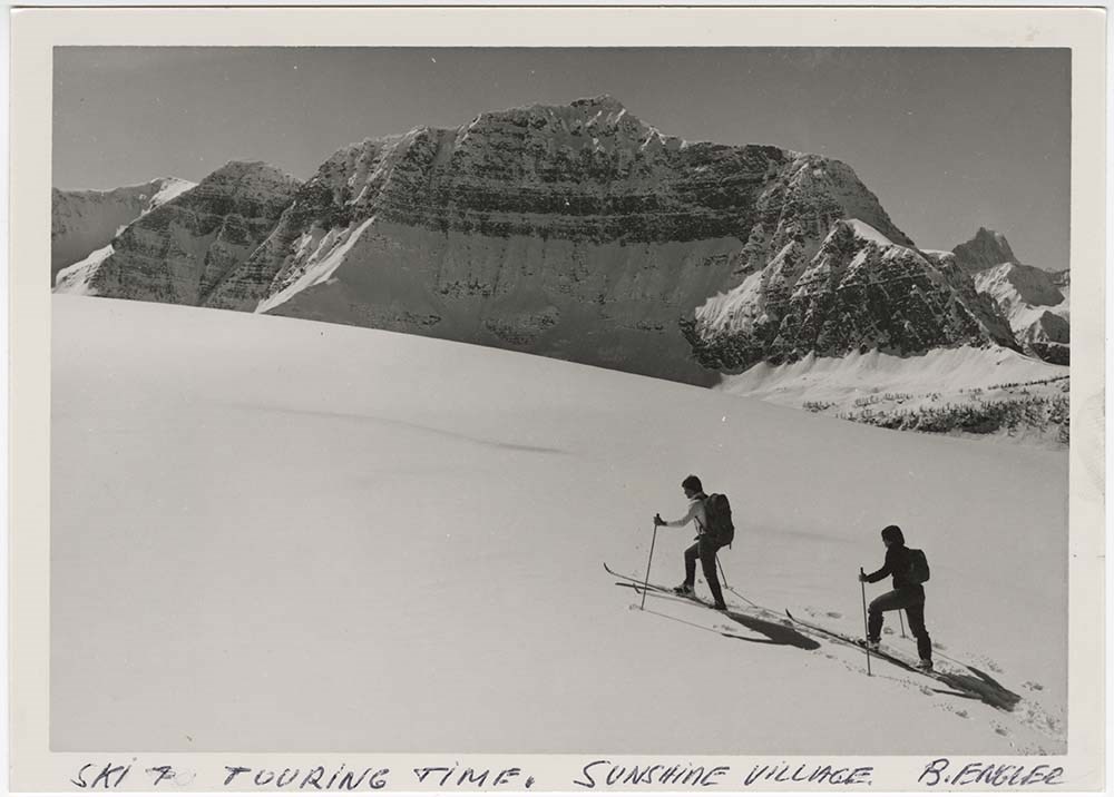
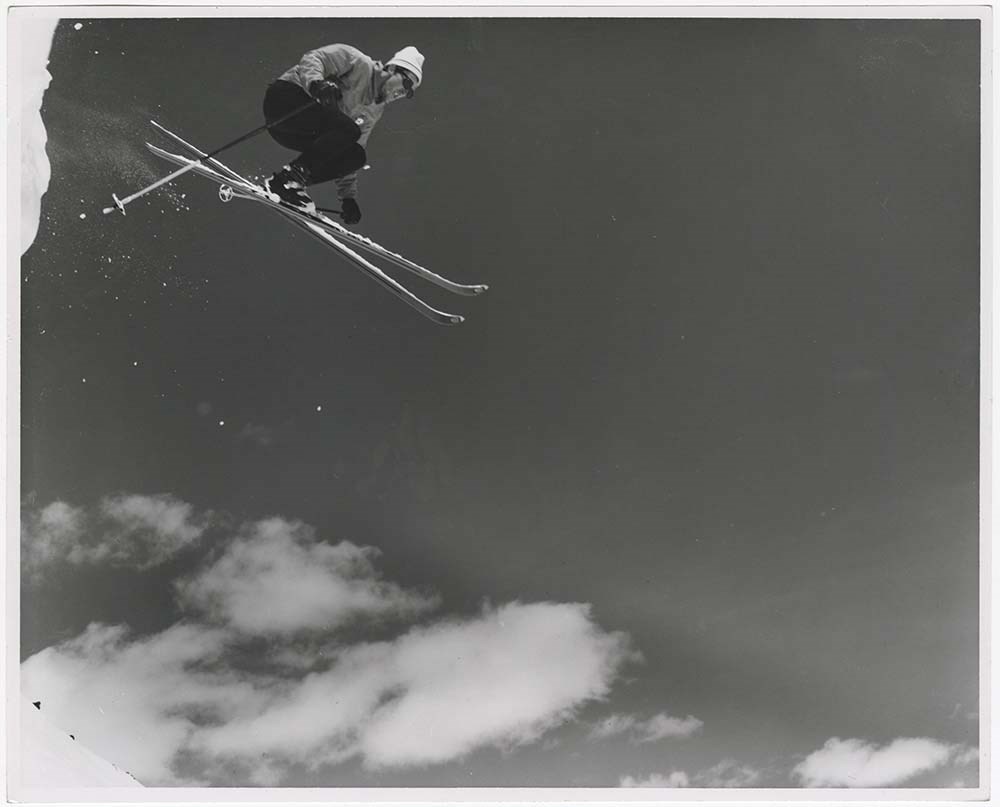
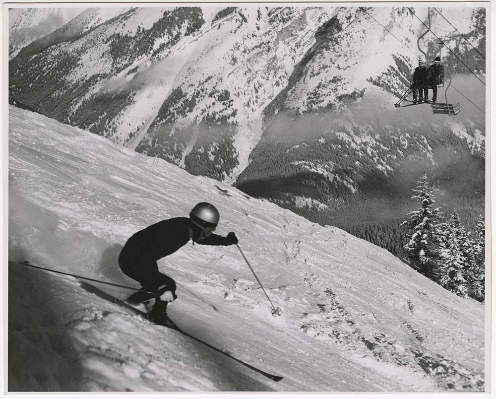
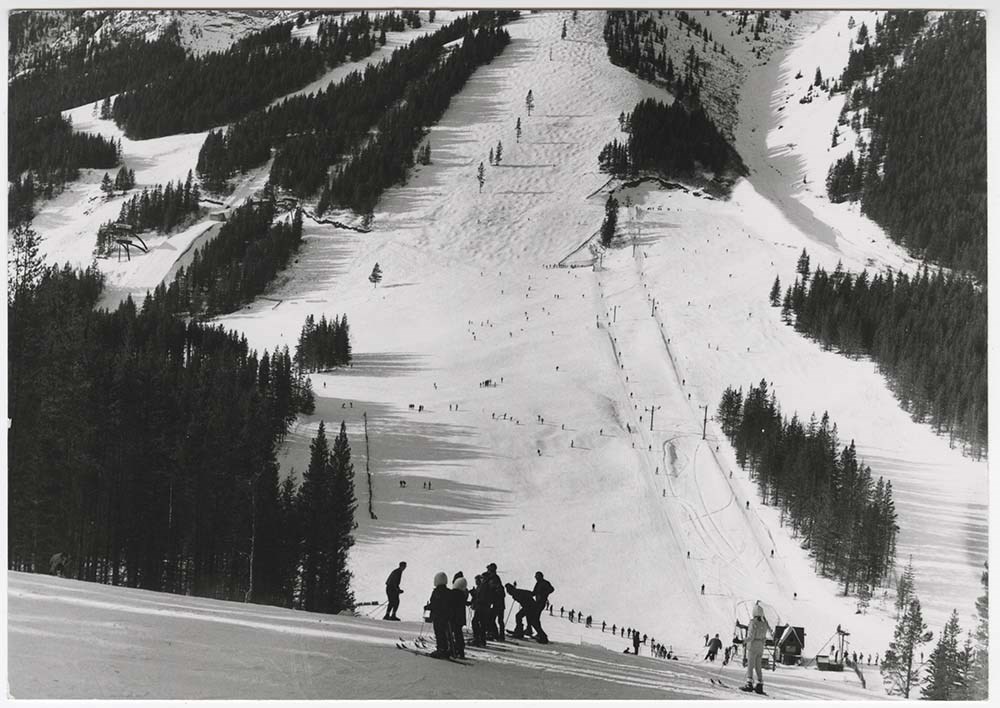
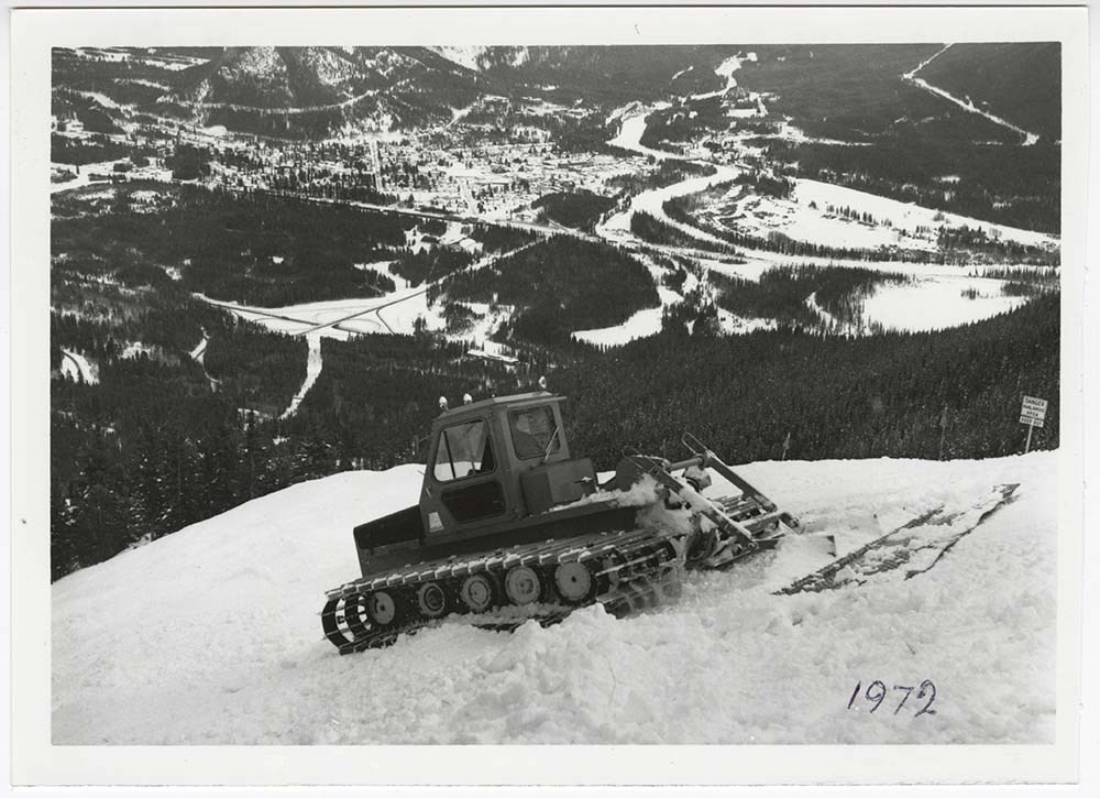
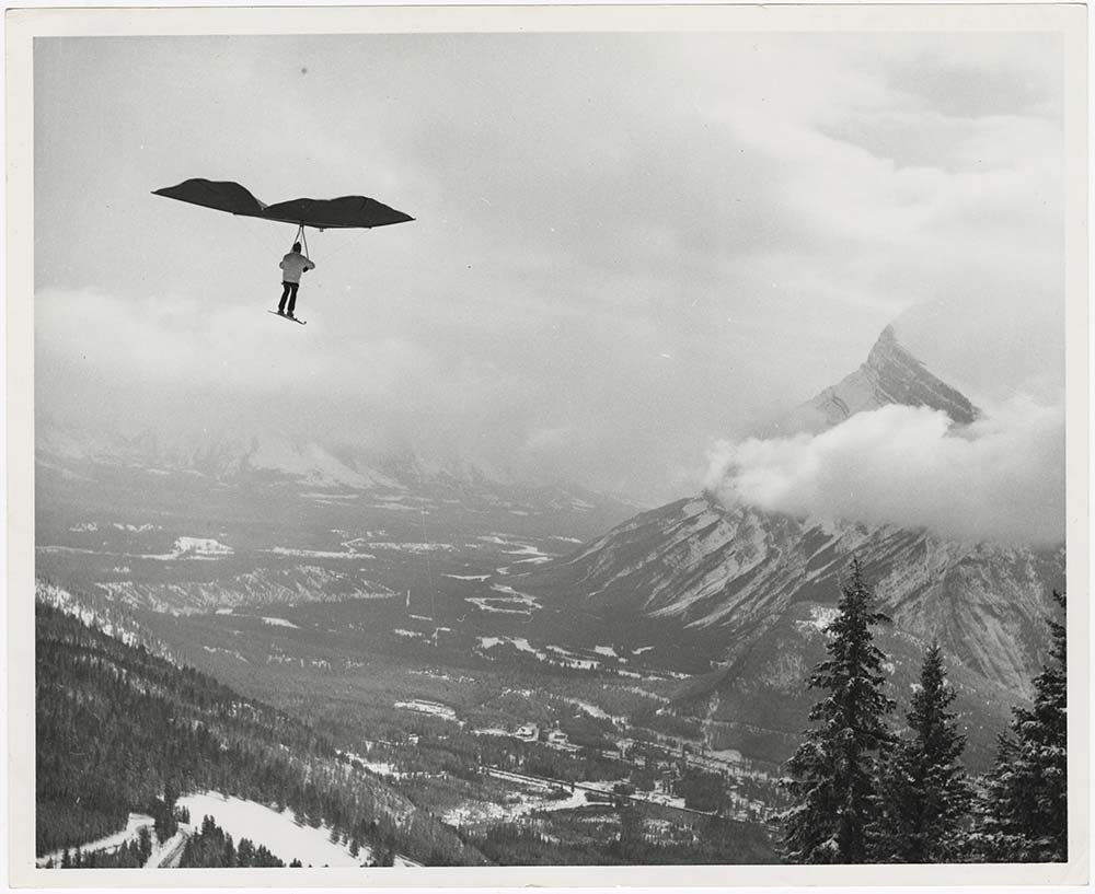
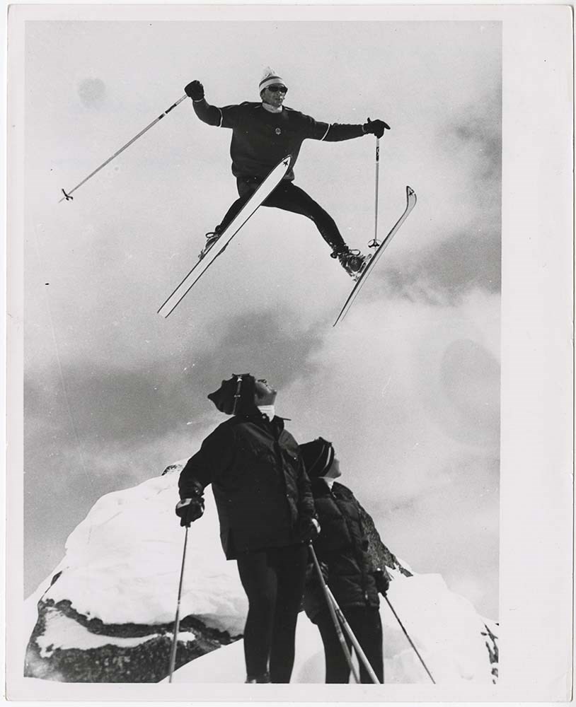
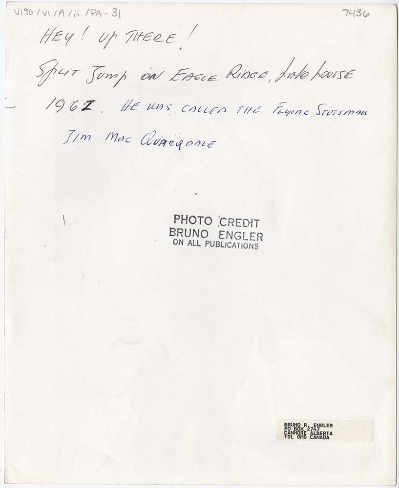
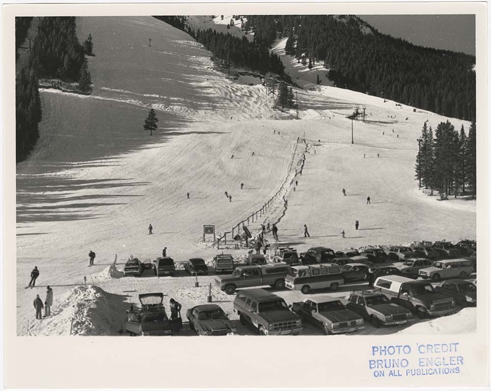
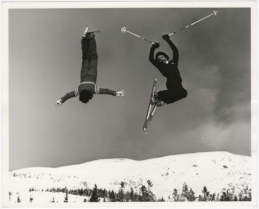
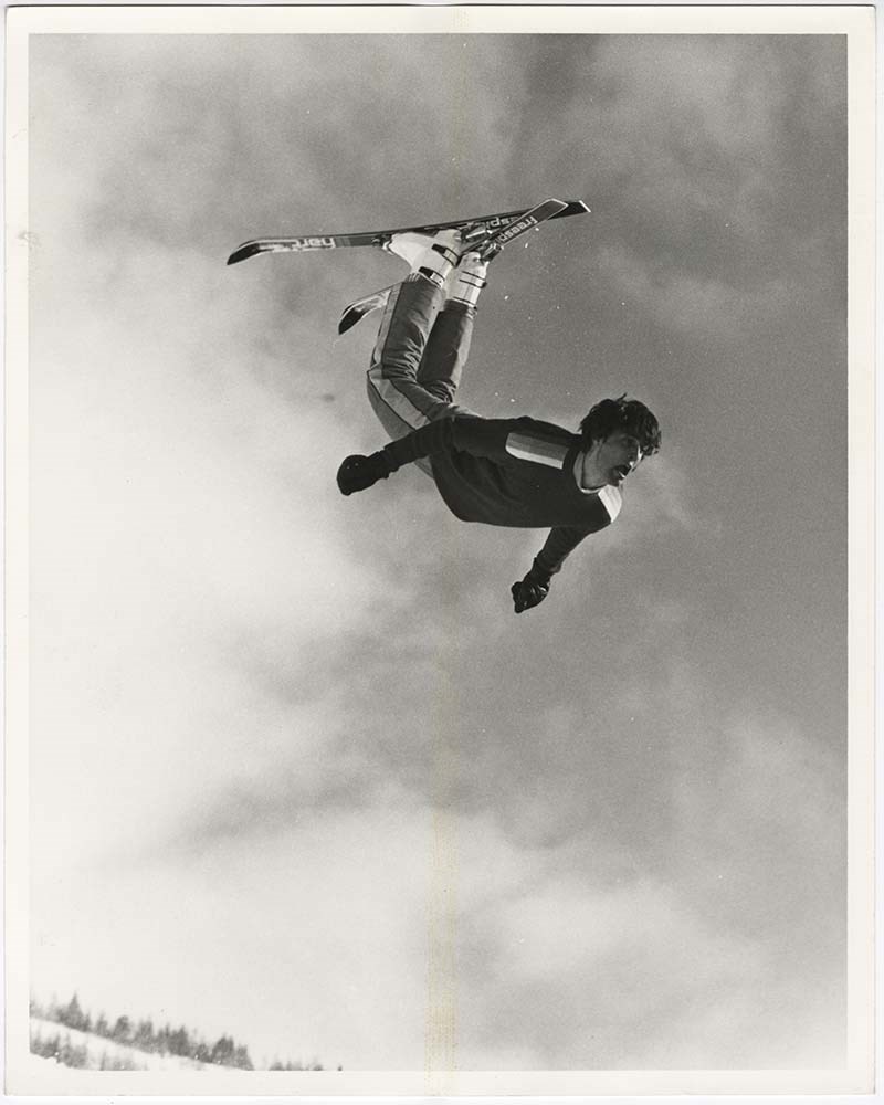
Action on Skis
https://archives.whyte.org/en/permalink/descriptions56697
- Part Of
- Bruno Engler fonds
- Scope & Content
- File pertains to 38 b&w prints of people skiing. Includes action shots of people skiing at Norquay, Lake Louise, and Sunshine, the Norquay parking lot, ski jumping, ski racing, and an unidentified person paragliding on skis at Norquay.
- Date Range
- [ca. 1948-1980]
- Reference Code
- V190 / VI / A / ii / PA - 01 to PA - 38
- Description Level
- 5 / File
- GMD
- Photograph print
12 images
- Part Of
- Bruno Engler fonds
- Description Level
- 5 / File
- Fonds Number
- M323 / S40 / V190
- Series
- VI : Retained file, A : Alphabetical order
- Sous-Fonds
- V190
- Sub-Series
- ii : Action on Skis
- Accession Number
- 7436
- Reference Code
- V190 / VI / A / ii / PA - 01 to PA - 38
- Date Range
- [ca. 1948-1980]
- Physical Description
- 38 photographs : b&w ; 25.5 x 20.5 cm or smaller
- History / Biographical
- See fonds level description
- Scope & Content
- File pertains to 38 b&w prints of people skiing. Includes action shots of people skiing at Norquay, Lake Louise, and Sunshine, the Norquay parking lot, ski jumping, ski racing, and an unidentified person paragliding on skis at Norquay.
- Name Access
- Engler, Bruno
- Subject Access
- Activities
- Lake Louise Ski Area
- Mountains
- Norquay Ski Hill
- Ski areas
- Ski jumping
- Ski racing
- Skiing
- Sports and leisure
- Sunshine Ski Resort
- Winter
- Winter sports
- Geographic Access
- Banff
- Lake Louise
- Banff National Park
- Alberta
- Language
- English
- Creator
- Engler, Bruno
- Title Source
- Original title kept
- Processing Status
- Processed
Images
This material is presented as originally created; it may contain outdated cultural descriptions and
potentially offensive content.
Read more.
Aeromagnetic total field map[s], British Columbia
https://archives.whyte.org/en/permalink/catalogue24750
- Medium
- Library - Book (including soft-cover and pamphlets)
- Map
- Published Date
- 1995
- Publisher
- Ottawa : Geological Survey of Canada
- Call Number
- C7-3.21 a-f
- Publisher
- Ottawa : Geological Survey of Canada
- Published Date
- 1995
- Physical Description
- 6 maps : black and white
- Scale
- Scale: 1:1,000,000
- Notes
- Open file 2784
- Base map used was reproduced from a 1:250,000 tophographical map published by the Department of Energy, Mines and Resources, Ottawa
- Contents: 82N/NW -- 82N/SW -- 82K/NW -- 82K/SW -- 82K/NE -- 82K/SE
- Accession Number
- 28,500
- Call Number
- C7-3.21 a-f
- Collection
- Archives Library
This material is presented as originally created; it may contain outdated cultural descriptions and
potentially offensive content.
Read more.
Airline and RR shops, Pacific steamships, Atlantic steamships
https://archives.whyte.org/en/permalink/descriptions21576
- Part Of
- Nicholas Morant fonds
- Scope & Content
- File pertains mainly to Canadian Pacific Railway airline, railway and steamship operations
- Date Range
- [between 1930 and 1980]
- Reference Code
- V500 / C1 / 1
- Description Level
- 5 / File
- GMD
1 image
- Part Of
- Nicholas Morant fonds
- Description Level
- 5 / File
- Fonds Number
- M300 / S20 / V500
- Series
- I.C. Photography : prints
- Sous-Fonds
- V500
- Accession Number
- .
- Reference Code
- V500 / C1 / 1
- GMD
- Date Range
- [between 1930 and 1980]
- Physical Description
- 32 photographs : prints, b/w
- Scope & Content
- File pertains mainly to Canadian Pacific Railway airline, railway and steamship operations
- Geographic Access
- Canada
- Processing Status
- Processed
Images

This material is presented as originally created; it may contain outdated cultural descriptions and
potentially offensive content.
Read more.
- Part Of
- Murray Hay fonds
- Scope & Content
- File consists of 144 photographs : col. negatives ; 35 m m; 12 prints : col. ; 42 x 35 cm or smaller ; 1 cm of visual material. File pertains to various projects Murray Hay was involved with related to Alaska, USA, particularly in the mid-1990s. File includes: aerial photographs of the landscape (A…
- Date Range
- ca.1990-ca.1999
- 1992
- 1994
- Reference Code
- V795 / II / D / i / 1-2
- Description Level
- 5 / File
- GMD
- Drawing
- Map
- Photograph print
- Negative
- Private record
- Textual record
- Part Of
- Murray Hay fonds
- Description Level
- 5 / File
- Fonds Number
- M570 / V795
- Series
- V795 / II : Unpublished Material
- Sous-Fonds
- V795
- Sub-Series
- V795 / II / D : International / i : United States of America
- Accession Number
- 2019.41
- Reference Code
- V795 / II / D / i / 1-2
- Date Range
- ca.1990-ca.1999
- 1992
- 1994
- Physical Description
- 144 photographs : col. negatives ; 35 mm
- 12 prints : col. ; 42 x 35 cm or smaller
- 1 cm of visual material
- Scope & Content
- File consists of 144 photographs : col. negatives ; 35 m m; 12 prints : col. ; 42 x 35 cm or smaller ; 1 cm of visual material. File pertains to various projects Murray Hay was involved with related to Alaska, USA, particularly in the mid-1990s. File includes: aerial photographs of the landscape (Anchorage area, Homer, Prince William Sound, Valdez); hand-drawn draft maps of the Prince William Sound region (created for a cruise line); a variety of printed maps with annotations demonstrating comments (including a fax with an attached map from Dana at Adventure Media International); and a variety of printed reproductions of draft maps (Alyeska Ski Resort, City of Anchorage for the 1992 Olympic Bid, and Glacier Bay and the Tongass National Forest).
- Notes
- Items not in oversize (negatives) stored in downstairs vault.
- Name Access
- Hay, Murray
- Subject Access
- Advertising
- Artist
- Ski Maps
- Map
- Cartography
- Sports and recreation
- Tourism
- Tourist information
- Travel
- Geography
- Winter
- Winter sports
- Ski area
- Olympic Games (Winter)
- Geographic Access
- Alaska
- United States
- Valdez
- Prince William Sound
- Anchorage
- Glacier Bay and Tongass National Forest
- Language
- English
- Conservation
- Masking tape should be removed and alternative preservation methods used in the future.
- Related Material
- M570 / IV / A / 2-3
- Creator
- Hay, Murray
- Title Source
- Title based on contents of file
- Processing Status
- Processed
This material is presented as originally created; it may contain outdated cultural descriptions and
potentially offensive content.
Read more.
- Part Of
- Murray Hay fonds
- Scope & Content
- File consists of 2 cm of textual records, 43 x 28 cm, or smaller. File pertains to Murray Hay's work on various projects in Alaska, USA, specifically the Mount Roberts Tramway in Juneau and Anchorage's Olympic Bid for the 1992 Winter Olympics. File includes a map and/or illustration of the Mount Ro…
- Date Range
- ca.1980-1997
- 1996
- 1997
- Reference Code
- M570 / IV / A / 2-3
- Description Level
- 5 / File
- GMD
- Textual record
- Private record
- Map
- Part Of
- Murray Hay fonds
- Description Level
- 5 / File
- Fonds Number
- M570 / V795
- Series
- M570 / IV : Murray Hay Personal Papers
- Sous-Fonds
- M570
- Sub-Series
- M570 / IV / A : Correspondence
- Accession Number
- 2019.41
- Reference Code
- M570 / IV / A / 2-3
- Date Range
- ca.1980-1997
- 1996
- 1997
- Physical Description
- 2 cm of textual records (43 x 28 cm or smaller)
- Scope & Content
- File consists of 2 cm of textual records, 43 x 28 cm, or smaller. File pertains to Murray Hay's work on various projects in Alaska, USA, specifically the Mount Roberts Tramway in Juneau and Anchorage's Olympic Bid for the 1992 Winter Olympics. File includes a map and/or illustration of the Mount Roberts Tramway in Juneau, Alaska; handwritten correspondence between Hay and "Ms. Hunter" and the mailing slip (1997); a rough sketch of Hay's illustrations; tourism information related to the Mount Roberts Tramway; and correspondence and a draft example of the map for the Olympic Bid.
- Notes
- The Mount Roberts Tramway has been in operation since 1996.
- M570 / IV / A / 3 : date based on the potential connection between the records and the Olympic bid process for the 1992 Winter Olympics, for which Anchorage (Alyeska) submitted a bid using maps created by Murray Hay. The selection was determined in 1986.
- Records were originally filed in two envelopes, labelled: "Mt. Roberts Trmw." and "Prince William Sound - Valdez." File titles reflect this.
- Name Access
- Hay, Murray
- Subject Access
- Advertising
- Artist
- Cartography
- Discovery and travel
- Leisure
- Map
- Tourism
- Tourist information
- Travel
- Ski area
- Ski Maps
- Sports and recreation
- Winter
- Winter sports
- Olympic Games (Winter)
- Geographic Access
- Alaska
- United States of America
- Juneau
- Valdez
- Prince William Sound
- Language
- English
- Title Source
- Title based on contents of file
- Processing Status
- Processed
This material is presented as originally created; it may contain outdated cultural descriptions and
potentially offensive content.
Read more.
Alberta and British Columbia [road map]
https://archives.whyte.org/en/permalink/catalogue24411
- Medium
- Library - Maps and blueprints (unannotated; published)
- Map
- Published Date
- 1953
- Publisher
- Imperial Esso Touring Service
- Call Number
- C9-1.21
- Publisher
- Imperial Esso Touring Service
- Published Date
- 1953
- Physical Description
- 8 maps on 1 sheet : col
- Scale
- Scale: 1 inch = ca 30 1/2 miles
- Subjects
- Alberta
- British Columbia
- Notes
- Contents : Alberta. -- British Columbia
- Insets feature maps of Edmonton, Calgary, Vancouver, Victoria, Alaska Highway, Fraser Valley. Cover features Waterton Lakes with Prince of Wales Hotel
- Accession Number
- 6787
- Call Number
- C9-1.21
- Collection
- Archives Library
This material is presented as originally created; it may contain outdated cultural descriptions and
potentially offensive content.
Read more.
Alberta endangered wilderness / Alberta Wilderness Association
https://archives.whyte.org/en/permalink/catalogue21409
- Medium
- Library - Maps and blueprints (unannotated; published)
- Map
- Published Date
- 1990
- Publisher
- [Calgary?] : The Association
- Call Number
- C9-5.19
- Publisher
- [Calgary?] : The Association
- Published Date
- 1990
- Physical Description
- 1 map : col
- Accession Number
- SL 94B24KXP
- Call Number
- C9-5.19
- Collection
- Archives Library
This material is presented as originally created; it may contain outdated cultural descriptions and
potentially offensive content.
Read more.
[Alberta] Resources and Development
https://archives.whyte.org/en/permalink/catalogue24423
- Medium
- Library - Maps and blueprints (unannotated; published)
- Map
- Published Date
- 1952
- Publisher
- A. Shnitka, Qheens' Printer for Alberta
- Call Number
- C9-5.1
- Publisher
- A. Shnitka, Qheens' Printer for Alberta
- Published Date
- 1952
- Physical Description
- 1 map : col
- Scale
- Scale: 1 inch: 20 miles
- Subjects
- Alberta
- Accession Number
- 372
- Call Number
- C9-5.1
- Collection
- Archives Library
This material is presented as originally created; it may contain outdated cultural descriptions and
potentially offensive content.
Read more.
Alberta road map
https://archives.whyte.org/en/permalink/catalogue24410
- Medium
- Library - Maps and blueprints (unannotated; published)
- Map
- Published Date
- 1990
- Publisher
- Edmonton : Alberta Tourism
- Call Number
- C9-1.20
- Publisher
- Edmonton : Alberta Tourism
- Published Date
- 1990
- Physical Description
- 14 maps on 1 sheet
- Scale
- Scale: 1:500,000
- Subjects
- Alberta
- Notes
- Province of Alberta, Canada 1990 official road map
- Cover title: Alberta road map
- Maps of principal towns and cities on reverse
- Info file transfer
- Call Number
- C9-1.20
- Collection
- Archives Library
This material is presented as originally created; it may contain outdated cultural descriptions and
potentially offensive content.
Read more.
Alts Golf and Ski Resort, Japan
https://archives.whyte.org/en/permalink/descriptions54972
- Part Of
- Murray Hay fonds
- Scope & Content
- File consists of 4 prints : col. ; 22 x 15.5 cm or smaller on sheet 35 x 30 cm. FIle pertains to Murray Hay's work for Alts Golf and Ski Resort in Japan. File includes multiple prints glued/taped to a sheet of paper depicting different areas of the ski area, and is titled "Alts Golf and Ski Resort …
- Date Range
- ca. 1976 - ca. 2000
- Reference Code
- V795 / II / D / ii / 1
- Description Level
- 5 / File
- GMD
- Map
- Private record
- Part Of
- Murray Hay fonds
- Description Level
- 5 / File
- Fonds Number
- M570 / V795
- Series
- V795 / II : Unpublished Material
- Sous-Fonds
- V795
- Sub-Series
- V795 / II / D : International / ii : Miscellaneous
- Accession Number
- 2019.41
- Reference Code
- V795 / II / D / ii / 1
- GMD
- Map
- Private record
- Date Range
- ca. 1976 - ca. 2000
- Physical Description
- 4 prints : col. ; 22 x 15.5 cm or smaller on sheet 35 x 30 cm
- Scope & Content
- File consists of 4 prints : col. ; 22 x 15.5 cm or smaller on sheet 35 x 30 cm. FIle pertains to Murray Hay's work for Alts Golf and Ski Resort in Japan. File includes multiple prints glued/taped to a sheet of paper depicting different areas of the ski area, and is titled "Alts Golf and Ski Resort in the Bandai Area of Japan."
- Name Access
- Hay, Murray
- Subject Access
- Advertising
- Artist
- Ski Maps
- Map
- Cartography
- Sports and recreation
- Tourism
- Tourist information
- Travel
- Winter
- Winter sports
- Ski area
- Geographic Access
- Japan
- Language
- English
- Conservation
- Prints are taped or otherwise glued to the sheet of paper. Adhesives should be removed and alternative preservation methods used at a reasonable time to do so.
- Related Material
- M570 / III / D / ii / 2
- Creator
- Hay, Murray
- Title Source
- Title based on contents of file
- Processing Status
- Processed
This material is presented as originally created; it may contain outdated cultural descriptions and
potentially offensive content.
Read more.
[Anahim Lake 93C, B.C.]
https://archives.whyte.org/en/permalink/catalogue24005
- Medium
- Library - Maps and blueprints (unannotated; published)
- Map
- Published Date
- 1955
- Publisher
- Dept. of Mines and Technical Surveys
- Call Number
- NTS
- 93C
- Publisher
- Dept. of Mines and Technical Surveys
- Published Date
- 1955
- Physical Description
- 1 map : col
- Scale
- Scale: 1:250,000
- Relief: Contour interval 500 ft.
- Subjects
- Anahim Lake
- British Columbia
- Accession Number
- 3000
- Call Number
- NTS
- 93C
- Collection
- Archives Library
This material is presented as originally created; it may contain outdated cultural descriptions and
potentially offensive content.
Read more.
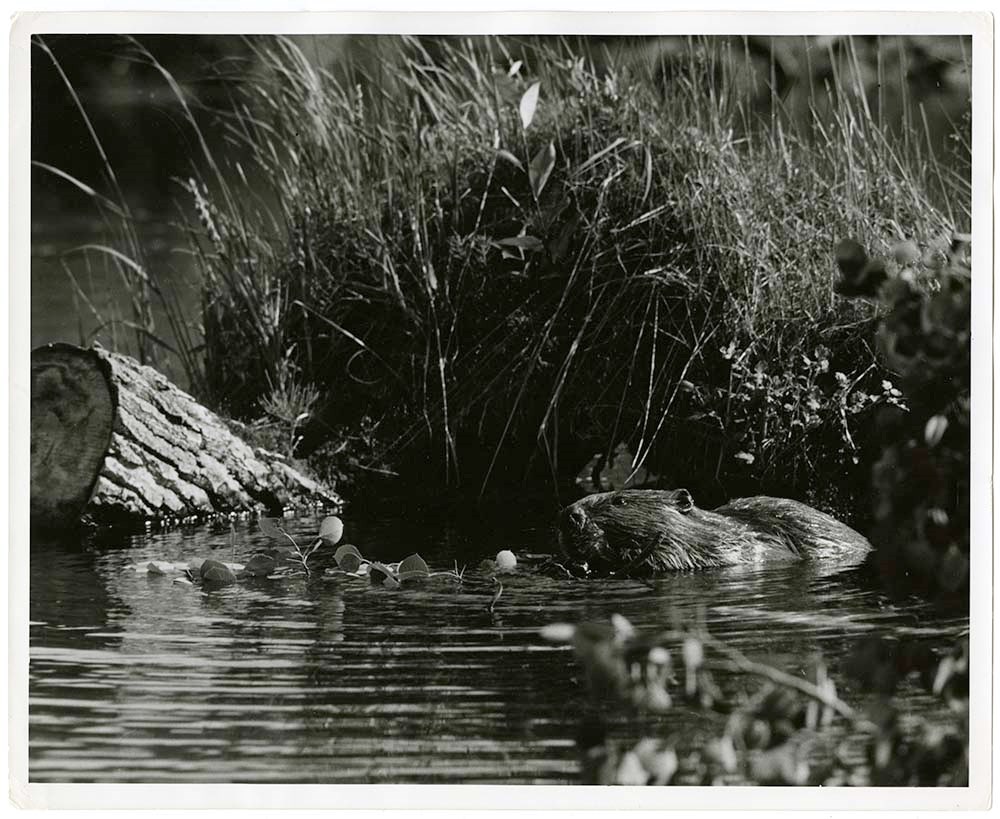
- Part Of
- Nicholas Morant fonds
- Scope & Content
- File pertains mainly to Rocky Mountain wildlife, including bear, moose, mountain sheep, beaver, muskrat, squirrel, osprey, Canada goose and other birds. Also includes domestic sheep, cattle and horses
- Date Range
- [between 1930 and 1980]
- Reference Code
- V500 / C1 / 4, 5
- Description Level
- 5 / File
- GMD
3 images
- Part Of
- Nicholas Morant fonds
- Description Level
- 5 / File
- Fonds Number
- M300 / S20 / V500
- Series
- I.C. Photography : prints
- Sous-Fonds
- V500
- Accession Number
- .
- Reference Code
- V500 / C1 / 4, 5
- GMD
- Date Range
- [between 1930 and 1980]
- Physical Description
- 41 photographs : prints, b/w
- Scope & Content
- File pertains mainly to Rocky Mountain wildlife, including bear, moose, mountain sheep, beaver, muskrat, squirrel, osprey, Canada goose and other birds. Also includes domestic sheep, cattle and horses
- Geographic Access
- Alberta
- Processing Status
- Processed
Images


This material is presented as originally created; it may contain outdated cultural descriptions and
potentially offensive content.
Read more.
Antique Maps of India and Germany, Walter Wilcox Mounts
https://archives.whyte.org/en/permalink/descriptions54204
- Part Of
- Nicholas Morant fonds
- Scope & Content
- File consists of 13 antique maps, 6 of which depict regions in India and 7 which depict regions in Germany. Content pertains to a small map collection originally issued to Tim Ffrench (?) during WWII which were later owned by Nicholas Morant. Some maps of reserves contain personal annotations and h…
- Date Range
- 1868
- 1892
- 1894
- 1903
- 1904
- 1917
- 1921
- 1950
- Reference Code
- M300 / III / D / 5 / 54 to 66 O.S. & V500 / III / D / 5 / PA - 96 O.S.
- Description Level
- 5 / File
- GMD
- Map
- Textual record
- Part Of
- Nicholas Morant fonds
- Description Level
- 5 / File
- Fonds Number
- V500
- Sous-Fonds
- V500
- Sub-Series
- M300 & V500 / III / D / 5 : Personal Interest and Gifts
- Accession Number
- 7784
- Reference Code
- M300 / III / D / 5 / 54 to 66 O.S. & V500 / III / D / 5 / PA - 96 O.S.
- GMD
- Map
- Textual record
- Other Title Info
- Parallel title is original title
- Responsibility
- Nicholas Morant
- Date Range
- 1868
- 1892
- 1894
- 1903
- 1904
- 1917
- 1921
- 1950
- Physical Description
- 13 Maps: print; b&w, and set of 4 rag paper mounts
- Scope & Content
- File consists of 13 antique maps, 6 of which depict regions in India and 7 which depict regions in Germany. Content pertains to a small map collection originally issued to Tim Ffrench (?) during WWII which were later owned by Nicholas Morant. Some maps of reserves contain personal annotations and highlighted/coloured routes; none of German maps are annotated. File also contains set of 4 rag paper mounts, annotated. 3 naming artist Walter Wilcox (likely formerly held his works but are now blank). One labelled 'Model'.
- Notes
- Maps were originally stored together in one poster tube labelled: "MAPS OF GERMANY INDIA See notes inside" Shipping label: PLS HOLD Armand To Nicholas Morant 222 Melville Ave Westmount Montreal" (with two 3 - cent stamps attached) Note inside, written by Nicholas Morant: "These maps were among those issued to Capt. Tim Ffrench (?) preparatory to intelligence work done during W. War II" Signed "Nick M." Wilcox mounts were stored in brown paper packaging with several other blank mounts (disposed of). Labelled section of original paper packaging has been stored with mounts in oversize box for reference.
- Geographic Access
- Germany
- India
- Access Restrictions
- Items in this file are not to be accessed or distributed without the explicit permission of their identified owners
- Reproduction Restrictions
- Items in this file are not to be reproduced without the explicit permission of their identified owners.
- Language
- English
- German
- Conservation
- Items must be kept only with items of similar materials, and stored with protective acid-free barriers to prevent further damage.
- Title Source
- Title based on contents of file
- Processing Status
- Processed
This material is presented as originally created; it may contain outdated cultural descriptions and
potentially offensive content.
Read more.
Apex Mountain Ski Resort
https://archives.whyte.org/en/permalink/descriptions54875
- Part Of
- Murray Hay fonds
- Scope & Content
- File consists of 1 map (1 base, 4 overlays) : col., annotations, on mylar ; 83 x 61.5 cm, and 1 print : b&w ; 25.5 x 20.5 cm. File pertains to ski maps Murray Hay created for Apex Mountain Ski Resort in Penticton, British Columbia. File includes one oversize map with four overlays (held together wi…
- Date Range
- ca.1976-ca.2000
- Reference Code
- V795 / II / A / iv / 3-4
- Description Level
- 5 / File
- GMD
- Map
- Private record
- Part Of
- Murray Hay fonds
- Description Level
- 5 / File
- Fonds Number
- M570 / V795
- Series
- V795 / II : Unpublished Material
- Sous-Fonds
- V795
- Sub-Series
- V795 / II / A : British Columbia / iv : Okanagan Area
- Accession Number
- 2019.41
- Reference Code
- V795 / II / A / iv / 3-4
- GMD
- Map
- Private record
- Date Range
- ca.1976-ca.2000
- Physical Description
- 1 map (1 base, 4 overlays) : col., annotations, on mylar ; 83 x 61.5 cm
- 1 print : b&w ; 25.5 x 20.5 cm
- Scope & Content
- File consists of 1 map (1 base, 4 overlays) : col., annotations, on mylar ; 83 x 61.5 cm, and 1 print : b&w ; 25.5 x 20.5 cm. File pertains to ski maps Murray Hay created for Apex Mountain Ski Resort in Penticton, British Columbia. File includes one oversize map with four overlays (held together with masking tape), and one print of the general ski area.
- Notes
- V795 / II / A / iv / 4 : has "16488" and "Hold" written in pencil on the masking tape.
- Name Access
- Hay, Murray
- Subject Access
- Advertising
- Art
- Artist
- Ski Maps
- Map
- Cartography
- Sports and recreation
- Tourism
- Tourist information
- Winter
- Winter sports
- Ski area
- Apex Mountain Ski Resort
- Geographic Access
- British Columbia
- Canada
- Penticton
- Language
- English
- Conservation
- The masking tape should be removed and alternative preservation methods should be considered at a reasonable time to do so.
- Creator
- Hay, Murray
- Title Source
- Title based on contents of file
- Processing Status
- Processed
This material is presented as originally created; it may contain outdated cultural descriptions and
potentially offensive content.
Read more.
Area of the Upper Missouri and Rocky Mts.
https://archives.whyte.org/en/permalink/catalogue21495
- Medium
- Library - Maps and blueprints (unannotated; published)
- Map
- Published Date
- 1801
- Call Number
- C12-1.20
- Published Date
- 1801
- Subjects
- Indian Map
- Notes
- Photostatic copy from Public Archives
- two sections
- Accession Number
- 675
- Call Number
- C12-1.20
- Collection
- Archives Library
This material is presented as originally created; it may contain outdated cultural descriptions and
potentially offensive content.
Read more.
- Part Of
- Murray Hay fonds
- Scope & Content
- File consists of 1 map : col., annotations, 96.5 x 69 cm. File pertains to an original unfinished hand-drawn map of interior Arizona in red, blue, black, and purple ink. Includes geographic features and labeled cities (including Yuma, Nogales, Bisbee, and Flagstaff).
- Date Range
- ca.1990-ca.1999
- Reference Code
- V795 / II / D / i / 4
- Description Level
- 5 / File
- GMD
- Drawing
- Map
- Private record
- Textual record
- Part Of
- Murray Hay fonds
- Description Level
- 5 / File
- Fonds Number
- M570 / V795
- Series
- V795 / II : Unpublished Material
- Sous-Fonds
- V795
- Sub-Series
- V795 / II / D : International / i : United States of America
- Accession Number
- 2019.41
- Reference Code
- V795 / II / D / i / 4
- Date Range
- ca.1990-ca.1999
- Physical Description
- 1 map : col., annotations ; 96.5 x 69 cm
- Scope & Content
- File consists of 1 map : col., annotations, 96.5 x 69 cm. File pertains to an original unfinished hand-drawn map of interior Arizona in red, blue, black, and purple ink. Includes geographic features and labeled cities (including Yuma, Nogales, Bisbee, and Flagstaff).
- Name Access
- Hay, Murray
- Subject Access
- Advertising
- Artist
- Ski Maps
- Map
- Cartography
- Sports and recreation
- Tourism
- Tourist information
- Travel
- Geography
- Winter
- Winter sports
- Ski area
- Geographic Access
- Arizona
- United States
- Language
- English
- Creator
- Hay, Murray
- Title Source
- Title based on contents of file
- Processing Status
- Processed
This material is presented as originally created; it may contain outdated cultural descriptions and
potentially offensive content.
Read more.
Arnold Wexler fonds
https://archives.whyte.org/en/permalink/descriptions592
- Part Of
- Arnold Wexler fonds
- Scope & Content
- Fonds consists of two series: I. Expeditions and trips series, 1946-1974; II. General files series, 1913-1978. Expeditions and trips series pertains to mountaineering expeditions and trips of Arnold Wexler and companions to western and northern Canada and locations in the United States. Canadian…
- Date Range
- 1913-1978, predominant 1946-1974
- Reference Code
- M69 / V52
- Description Level
- 1 / Fonds
- GMD
- Photograph
- Album
- Negative
- Photograph print
- Textual record
- Diary
- Map
- Private record
- Published record
- Part Of
- Arnold Wexler fonds
- Description Level
- 1 / Fonds
- Fonds Number
- M 69
- V 52
- Sous-Fonds
- M69/V52
- Accession Number
- 7196
- Reference Code
- M69 / V52
- GMD
- Photograph
- Album
- Negative
- Photograph print
- Textual record
- Diary
- Map
- Private record
- Published record
- Responsibility
- Arnold Wexler was responsible for the creation of most material. Fonds also contains material created by A. C. Faberge, Alvin E. Peterson, Donald Hubbard, William L. Putnam, Samuel V. Moore, Mike Banks, and others
- Date Range
- 1913-1978, predominant 1946-1974
- Physical Description
- ca.4100 photographs (ca.3000 transparencies, ca.700 negatives, ca.400 prints). -- 7 photograph albums (ca.190 prints). -- ca.40 cartographic records. -- 16 cm of textual records. -- 5 cm of print material. -- 5 graphic records
- History / Biographical
- Arnold Wexler, 1918-1997, was a research engineer and mountaineer in the Washington, DC area of the United States. He was a member of numerous scientific and mountaineering organizations and was actively involved in the testing of mountaineering equipment. Wexler climbed extensively in North America, Europe and South America, and also travelled throughout Asia. He is credited with over 100 ascents, almost half being first ascents.
- Wexler was a key organizer and participant of expeditions to western and northern Canada beginning in 1946. Noteworthy ascents of that first expedition, to the northern Selkirks of British Columbia, were the second ascent of Mount Sir Sandford and first ascents of Sentinel Peak, Unicorn and East Blackfriar. Also, near the end of that trip, an accident claimed the life of an expedition member. Wexler and his associates made annual expeditions and trips to Canada from 1946 until 1955, and subsequently in the years 1961, 1962, 1963, and 1970 through 1974
- Scope & Content
- Fonds consists of two series: I. Expeditions and trips series, 1946-1974; II. General files series, 1913-1978.
- Expeditions and trips series pertains to mountaineering expeditions and trips of Arnold Wexler and companions to western and northern Canada and locations in the United States. Canadian expedition destinations included the Selkirk Mountains, Cariboo Mountains, Rocky Mountains, Monashee Mountains, Coast Range, Bugaboo Mountains, Logan Mountains, Battle Range and Adamant Range. Mountaineers involved were Arnold Wexler, Sterling B. Hendricks, Donald Hubbard, Alvin (Pete) E. Peterson, Alex C. Faberge, Chris G. Scoredos, Charles C. Haworth Jr., Samuel V. Moore, Arthur Lembeck, Norman Goldstein, W. L. Putnam, A. J. Kauffman and others. Series includes extensive photographs, trip diaries and maps.
- General files series consists of files pertaining to mountaineering, equipment, locations, climbing associates and expeditions. Includes correspondence, checklists, exhibition prints, climbing portraits, and research material in the form of topical files, maps and print material
- Name Access
- Wexler, Arnold
- Subject Access
- Exploration, discovery and travel
- Science and technology
- Sports, recreation and leisure
- Access Restrictions
- Some restrictions on access to originals
- Copyright, privacy, commercial use and other restrictions may apply
- Language
- Language is English
- Finding Aid
- Finding aids and reference tools: arrangement outline
- series and file description
- electronic finding aid
- Creator
- Wexler, Arnold
- Biographical Source Notes
- Obituary by John Christian (see case file)
- Contents of the fonds
- Title Source
- Title based on contents of fonds
- Processing Status
- Processed
This material is presented as originally created; it may contain outdated cultural descriptions and
potentially offensive content.
Read more.
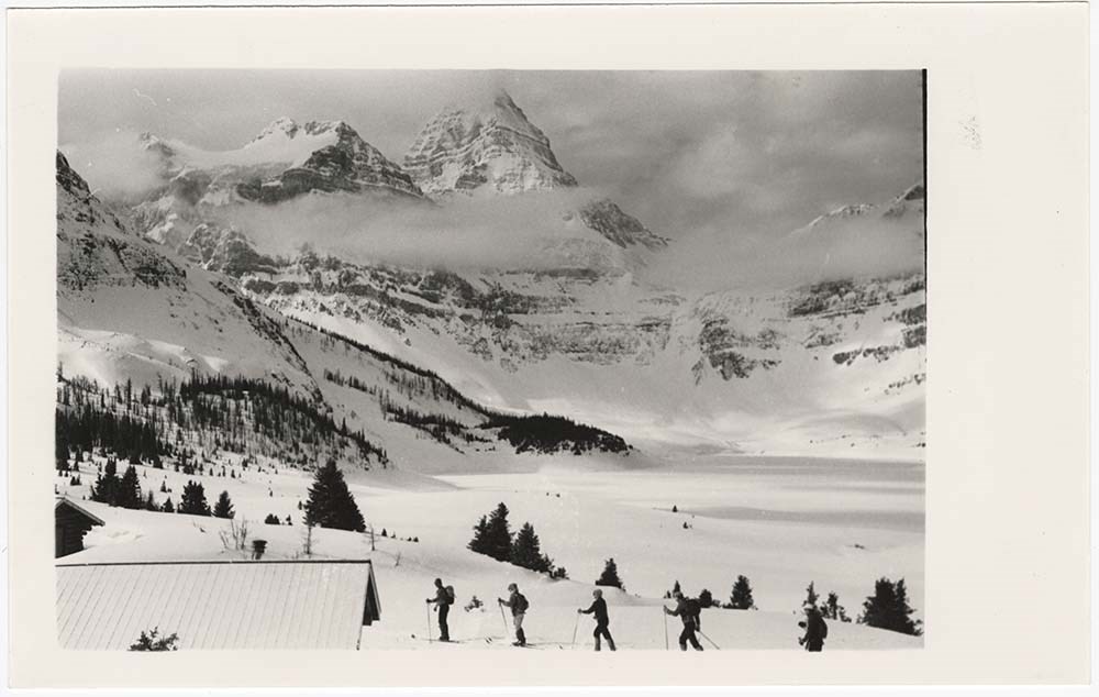
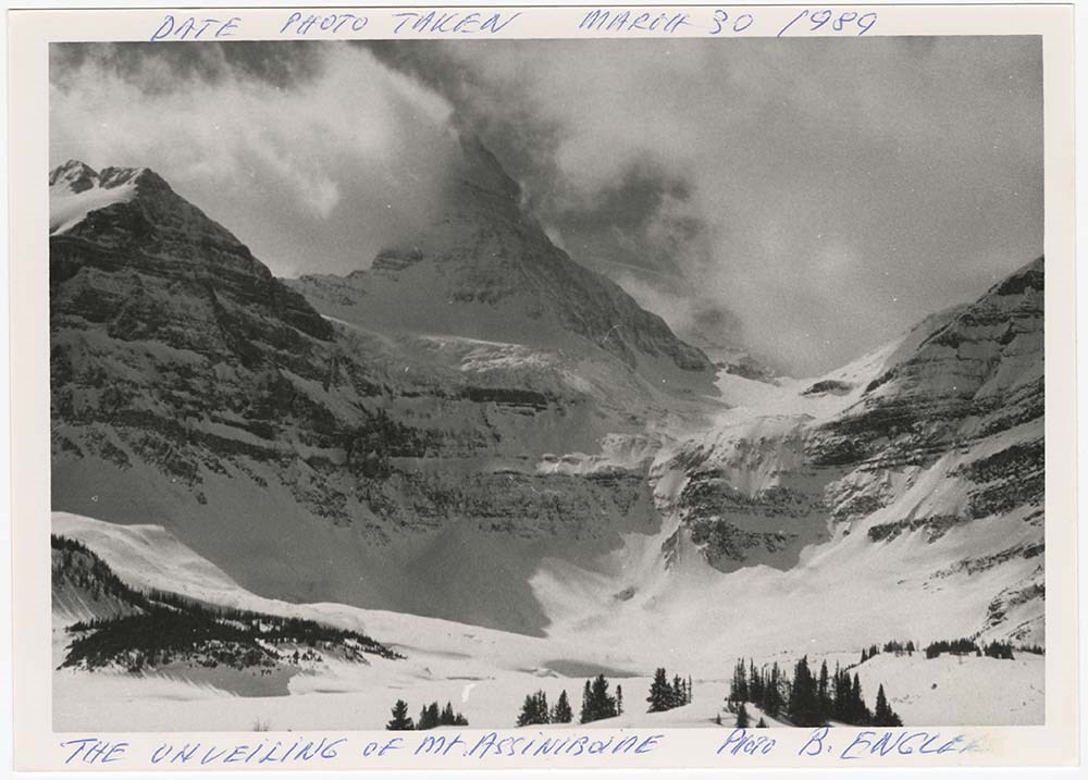
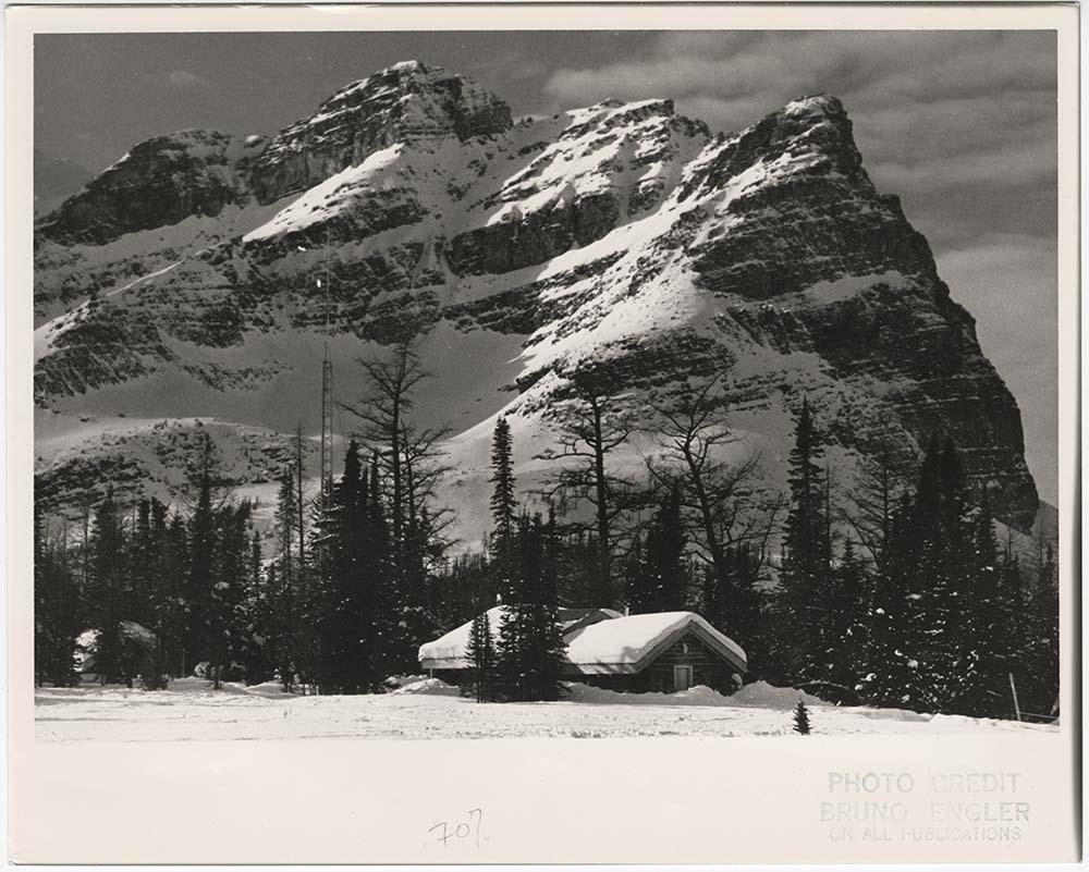
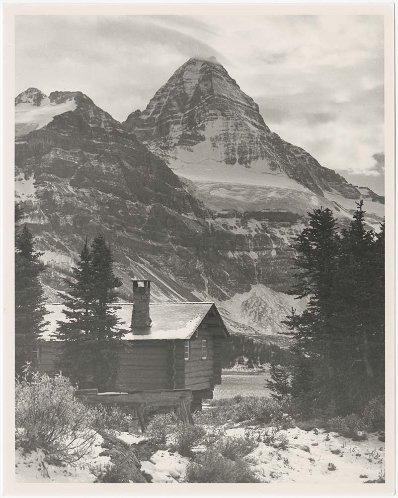
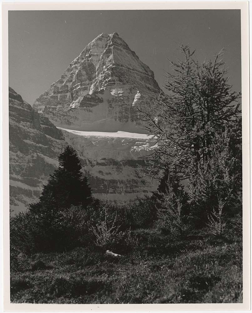
- Part Of
- Bruno Engler fonds
- Scope & Content
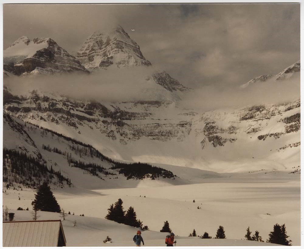
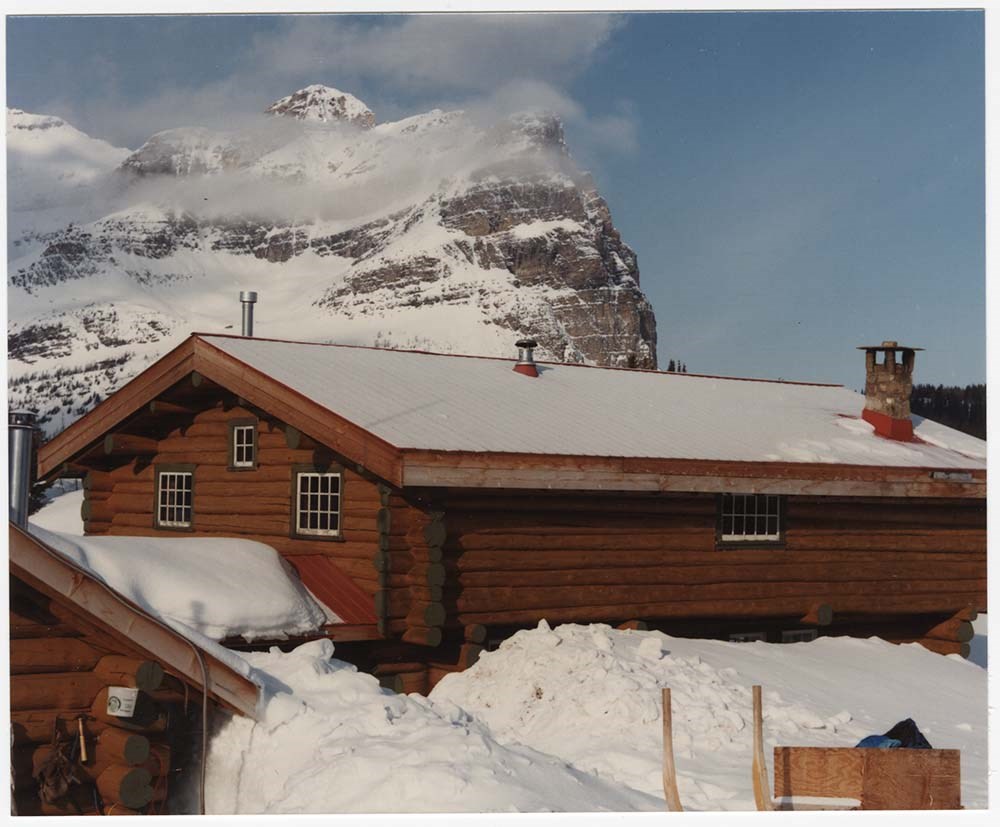
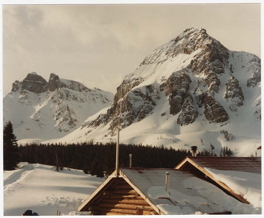
- File pertains to 46 colour and b&w prints of Mount Assiniboine and its surrounding area. Includes views of the mountain and Lake Magog, the lodge and huts, people skiing, helicopters at the lodge, an unidentified group of people posed in front of a cabin, and other scenic views in winter and summer.
- Date Range
- 1940-1989
- Reference Code
- V190 / VI / A / iv / PA - 01 to PA - 46
- Description Level
- 5 / File
- GMD
- Photograph print
11 images
- Part Of
- Bruno Engler fonds
- Description Level
- 5 / File
- Fonds Number
- M323 / S40 / V190
- Series
- VI : Retained file, A : Alphabetical order
- Sous-Fonds
- V190
- Sub-Series
- iv : Assiniboine
- Accession Number
- 7436
- Reference Code
- V190 / VI / A / iv / PA - 01 to PA - 46
- Date Range
- 1940-1989
- Physical Description
- 46 photographs : col. & b&w ; 25.5 x 20.5 cm or smaller
- History / Biographical
- See fonds level description
- Scope & Content
- File pertains to 46 colour and b&w prints of Mount Assiniboine and its surrounding area. Includes views of the mountain and Lake Magog, the lodge and huts, people skiing, helicopters at the lodge, an unidentified group of people posed in front of a cabin, and other scenic views in winter and summer.
- Name Access
- Engler, Bruno
- Subject Access
- Backcountry skiing
- Cabins and shelters
- Children
- Family and personal life
- Helicopters
- Hiking
- Mount Assiniboine
- Mountains
- Skiing
- Sports and leisure
- Winter
- Geographic Access
- Assiniboine
- Assiniboine Provincial Park
- British Columbia
- Language
- English
- Related Material
- V190 / VI / A / iv / NA - 01 to NA - 06 V190 / VI / A / iv / NS - 01 to NS - 06
- Creator
- Engler, Bruno
- Title Source
- Original title kept
- Processing Status
- Processed
Images


This material is presented as originally created; it may contain outdated cultural descriptions and
potentially offensive content.
Read more.
Astley family photographs
https://archives.whyte.org/en/permalink/descriptions54238
- Part Of
- Astley family fonds
- Scope & Content
- File consists of 2 b&w prints, some captioned. File pertains to a portrait of Lucy Ann Astley and a group posed in front log cabin, Lake Minnewanka, 1890. File also contains a copy of group photograph at Lake Minnewanka and brief biographical information and obituary of Lucy Ann Andrew.
- Date Range
- [ca.1886]-1970
- Reference Code
- V394 / PA - 42 to 43
- Description Level
- 5 / File
- GMD
- Photograph
- Part Of
- Astley family fonds
- Description Level
- 5 / File
- Fonds Number
- M 265
- V 394
- Sous-Fonds
- V 394
- Accession Number
- 7939
- Reference Code
- V394 / PA - 42 to 43
- GMD
- Photograph
- Date Range
- [ca.1886]-1970
- Physical Description
- Photographs: 2 prints, b&w
- History / Biographical
- See fonds level description
- Scope & Content
- File consists of 2 b&w prints, some captioned. File pertains to a portrait of Lucy Ann Astley and a group posed in front log cabin, Lake Minnewanka, 1890. File also contains a copy of group photograph at Lake Minnewanka and brief biographical information and obituary of Lucy Ann Andrew.
- Name Access
- Astley (family)
- Subject Access
- Buildings and facilities
- Environment
- Family and personal life
- Military
- Sports, recreation and leisure
- Access Restrictions
- Some restriction/s on access
- Copyright, privacy, commercial use and other restrictions may apply
- Language
- Language is English
- Creator
- Astley (family)
- Title Source
- Title based on contents of file
- Processing Status
- Processed
This material is presented as originally created; it may contain outdated cultural descriptions and
potentially offensive content.
Read more.
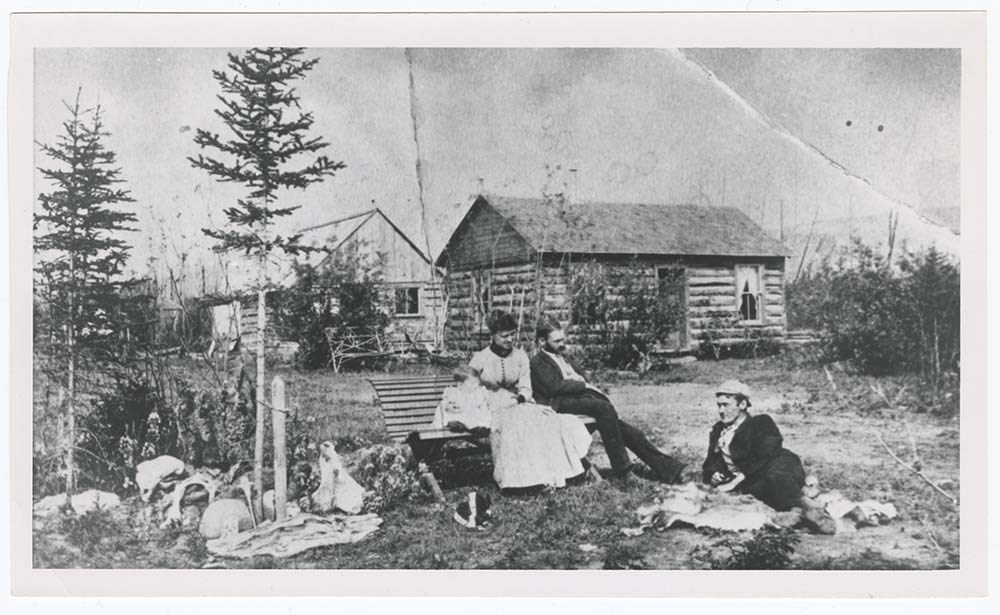
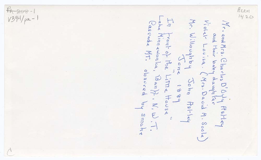
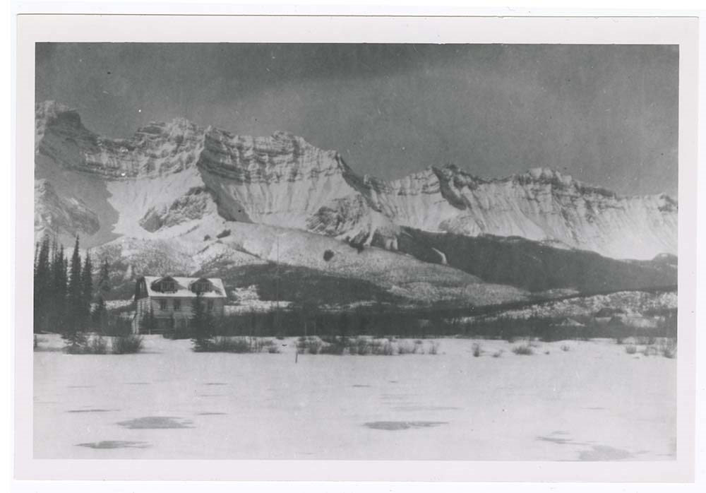
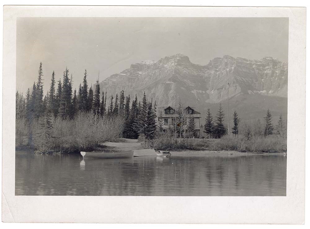
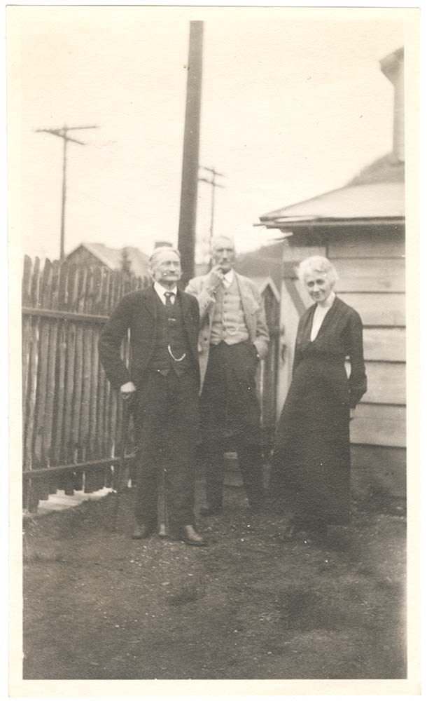
Astley family photographs
https://archives.whyte.org/en/permalink/descriptions54239
- Part Of
- Astley family fonds
- Scope & Content
- File consists of 42 b&w prints, some captioned. Photographs pertain to fishing and boating on Lake Minnewanka; Beach House Hotel and Lady of the Lake steam launch; Devil's Canyon, Bankhead and Banff; views of avalanche clearing in Roger's Pass by Byron Harmon. Includes one panorama view of group a…
- Date Range
- [ca.1886]-1970
- Reference Code
- V394 / PA - 1 to 42
- Description Level
- 5 / File
- GMD
- Photograph
8 images
- Part Of
- Astley family fonds
- Description Level
- 5 / File
- Fonds Number
- M 265
- V 394
- Sous-Fonds
- V 394
- Accession Number
- 1420
- 6353
- Reference Code
- V394 / PA - 1 to 42
- GMD
- Photograph
- Date Range
- [ca.1886]-1970
- Physical Description
- Photographs: 42 prints, b&w
- History / Biographical
- See fonds level description
- Scope & Content
- File consists of 42 b&w prints, some captioned. Photographs pertain to fishing and boating on Lake Minnewanka; Beach House Hotel and Lady of the Lake steam launch; Devil's Canyon, Bankhead and Banff; views of avalanche clearing in Roger's Pass by Byron Harmon. Includes one panorama view of group at Lake Minnewanka.
- Name Access
- Astley (family)
- Subject Access
- Buildings and facilities
- Environment
- Family and personal life
- Military
- Sports, recreation and leisure
- Access Restrictions
- Some restriction/s on access
- Copyright, privacy, commercial use and other restrictions may apply
- Language
- Language is English
- Creator
- Astley (family)
- Title Source
- Title based on contents of file
- Processing Status
- Processed
Images
This material is presented as originally created; it may contain outdated cultural descriptions and
potentially offensive content.
Read more.