Narrow Results By
Banff National Park (general)
https://archives.whyte.org/en/permalink/descriptions55338
- Part Of
- Murray Hay fonds
- Scope & Content
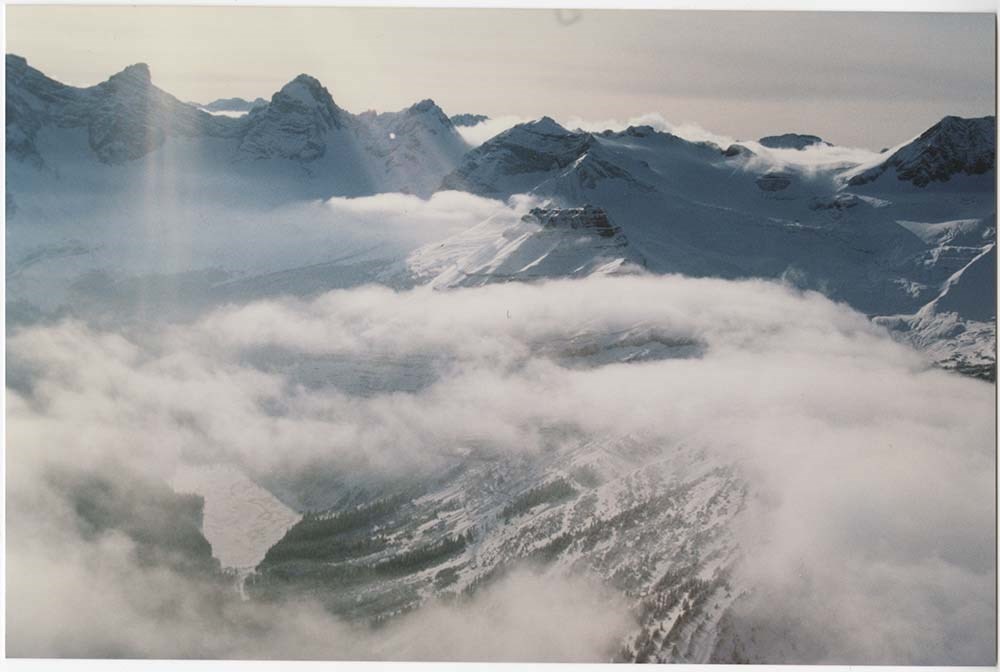
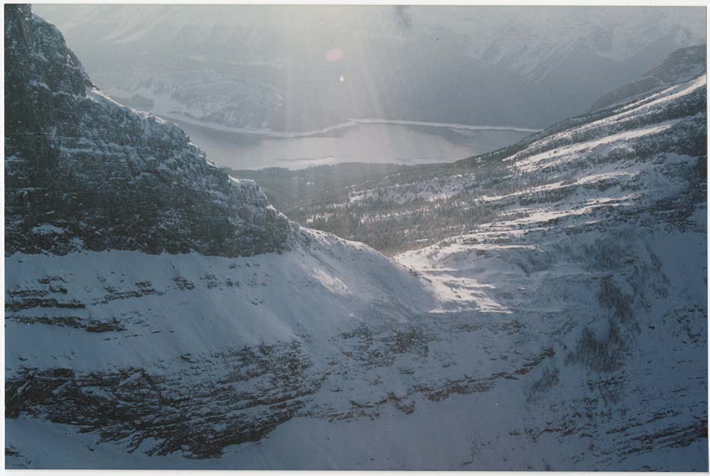
- File consists of 4 prings : col. 35.1 x 24.8 cm or smaller and 4 maps (2 paper, 2 overlays) : col., on mylar ; 60.4 x 30. cm or smaller. File pertains to aerial views of Banff National Park, showing the towns of Banff and Lake Louise, ski hills (Norqay Ski Hill, Sunshine Village, and Lake Louise Sk…
- Date Range
- ca.1976-ca.2000
- Reference Code
- V795 / II / B / v / 1-2
- Description Level
- 5 / File
- GMD
- Map
- Private record
- Part Of
- Murray Hay fonds
- Description Level
- 5 / File
- Fonds Number
- M570 / V795
- Series
- V795 / II : Unpublished Material
- Sous-Fonds
- V795
- Sub-Series
- V795 / II / B : Alberta / v : Banff National Park
- Accession Number
- 2019.41
- Reference Code
- V795 / II / B / v / 1-2
- GMD
- Map
- Private record
- Date Range
- ca.1976-ca.2000
- Physical Description
- 4 prints : col. 35.1 x 24.8 cm or smaller
- 4 maps (2 paper, 2 overlays) : col., annotations, on mylar ; 60.4 x 30. cm or smaller
- Scope & Content
- File consists of 4 prings : col. 35.1 x 24.8 cm or smaller and 4 maps (2 paper, 2 overlays) : col., on mylar ; 60.4 x 30. cm or smaller. File pertains to aerial views of Banff National Park, showing the towns of Banff and Lake Louise, ski hills (Norqay Ski Hill, Sunshine Village, and Lake Louise Ski Resort), as well as other georgraphic features. The mylar overlays contain various amounts of detail and annotations - one consists of a dark red sheet overlayed with place names in negative.
- Notes
- Items not in oversize stored in downstairs vault.
- Name Access
- Hay, Murray
- Subject Access
- Advertising
- Artist
- Ski Maps
- Map
- Cartography
- Sports and recreation
- Tourism
- Tourist information
- Winter
- Winter sports
- Ski area
- Sunshine Village
- Norquay Ski Hill
- Lake Louise Ski Area
- Geographic Access
- Banff
- Lake Louise
- Banff National Park
- Alberta
- Canada
- Canadian Rocky Mountains
- Language
- English
- Creator
- Hay, Murray
- Title Source
- Title based on contents of file
- Processing Status
- Processed
This material is presented as originally created; it may contain outdated cultural descriptions and
potentially offensive content.
Read more.
Friends, travel
https://archives.whyte.org/en/permalink/descriptions56319
- Part Of
- Ben Gadd fonds
- Scope & Content
- File consists of photographs taken or collected by Ben Gadd between 1983 and ca.1990. Images pertain to unnamed friends at Maligne Canyon; and views of Wisconsin, South Dakota and other regions of the United States.
- Date Range
- 1983
- [1985-1990]
- Reference Code
- V810 / I / D / PA - 1 to 12
- Description Level
- 5 / File
- GMD
- Photograph
- Part Of
- Ben Gadd fonds
- Description Level
- 5 / File
- Fonds Number
- M590
- V810
- S61
- Series
- V810 / I : Personal records
- Sous-Fonds
- V810
- Sub-Series
- V810 / I / D : Other personal and collected
- Accession Number
- 2021.20
- Reference Code
- V810 / I / D / PA - 1 to 12
- GMD
- Photograph
- Date Range
- 1983
- [1985-1990]
- Physical Description
- 12 photographs : col. prints ; 10 x 15 cm or smaller
- Scope & Content
- File consists of photographs taken or collected by Ben Gadd between 1983 and ca.1990. Images pertain to unnamed friends at Maligne Canyon; and views of Wisconsin, South Dakota and other regions of the United States.
- Notes
- Some photographs in file are annotated on back
- Name Access
- Gadd, Ben
- Subject Access
- Travel
- Tourism
- Hiking
- Recreation
- Environment
- Family and personal life
- Geographic Access
- Canada
- Alberta
- Maligne Canyon
- United States of America
- Wisconsin
- South Dakota
- Language
- English
- Category
- Family and personal life
- Environment
- Sports, recreation and leisure
- Exploration, discovery and travel
- Title Source
- Title based on contents of file
- Processing Status
- Processed
This material is presented as originally created; it may contain outdated cultural descriptions and
potentially offensive content.
Read more.
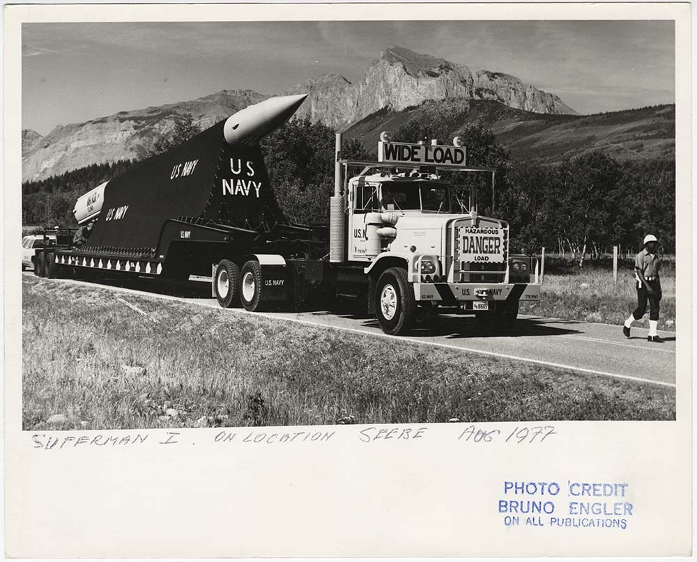
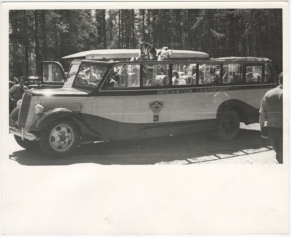
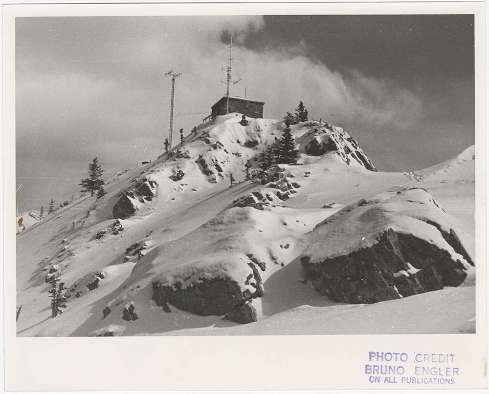
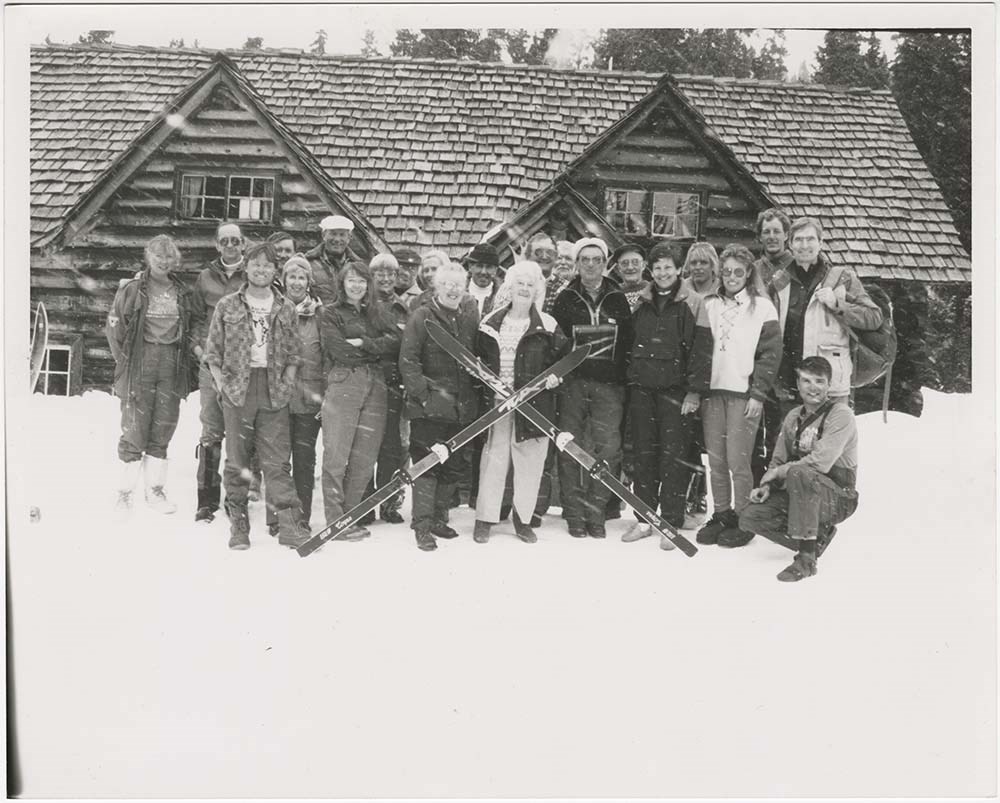
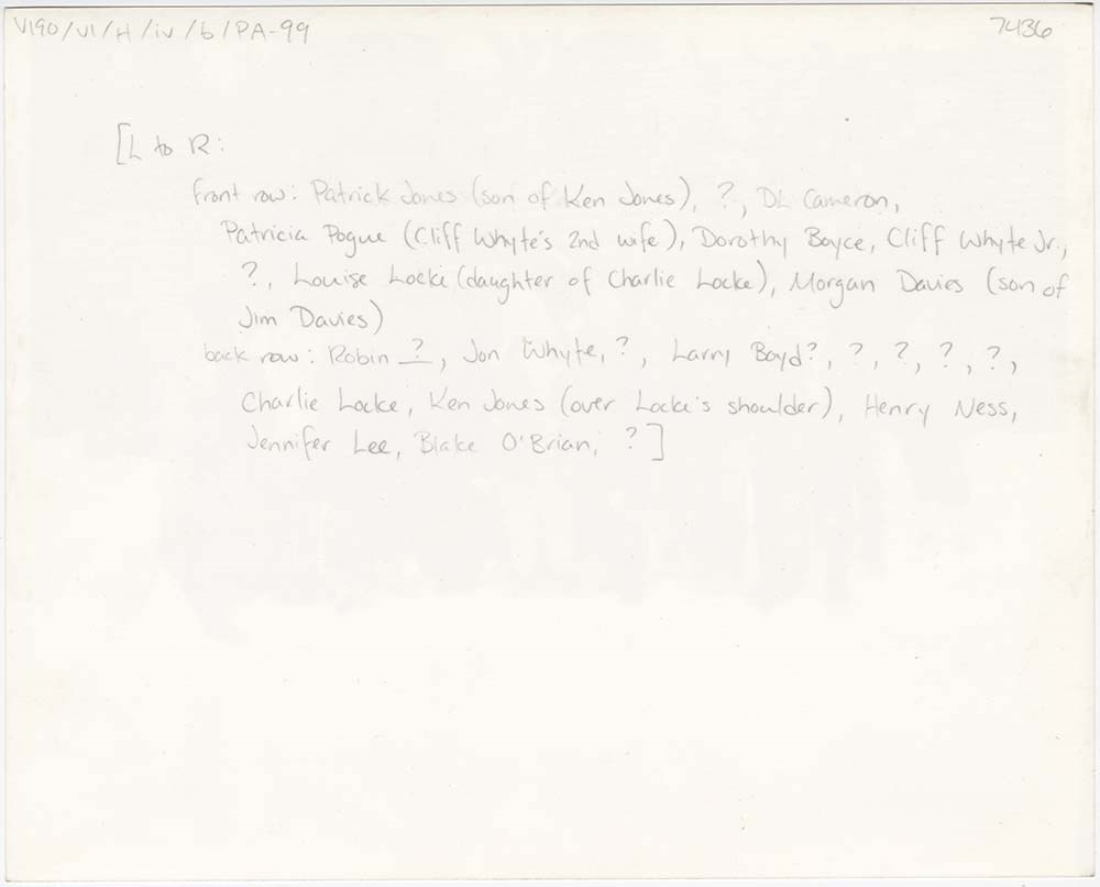
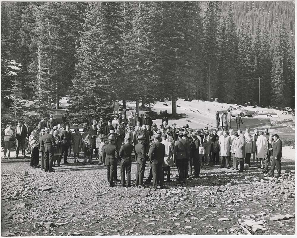
History Photos
https://archives.whyte.org/en/permalink/descriptions56901
- Part Of
- Bruno Engler fonds
- Scope & Content
- File pertains to 120 b&w prints of various historical topics, some photos taken by Bruno Engler, others collected [presumably] by him. Includes various Canadian Pacific Railway events, community events and celebrations, Skoki Lodge's 60th anniversary, the Norquay Ski Hill rope-tow, the 1968 Winter …
- Date Range
- [ca. 1886-1993]
- Reference Code
- V190 / VI / H / iv / b / PA - 01 to PA - 120
- Description Level
- 5 / File
- GMD
- Photograph
11 images
- Part Of
- Bruno Engler fonds
- Description Level
- 5 / File
- Fonds Number
- M323 / S40 / V190
- Series
- VI : Retained file, H : Alphabetical order
- Sous-Fonds
- V190
- Sub-Series
- iv : History, b : Photos
- Accession Number
- 7436
- Reference Code
- V190 / VI / H / iv / b / PA - 01 to PA - 120
- GMD
- Photograph
- Date Range
- [ca. 1886-1993]
- Physical Description
- 120 photographs : b&w ; 25.2 x 20.2 cm or smaller
- History / Biographical
- See fonds level description
- Scope & Content
- File pertains to 120 b&w prints of various historical topics, some photos taken by Bruno Engler, others collected [presumably] by him. Includes various Canadian Pacific Railway events, community events and celebrations, Skoki Lodge's 60th anniversary, the Norquay Ski Hill rope-tow, the 1968 Winter Olympics bid, Princess Margarite's [sic] visit in 1958, the Cosmic Ray Observatory operations, a Kiwanis Club event, ranching and ranch lands, portraits, and more.
- Name Access
- Perren, Walter
- Whyte, Catharine
- Whyte, Jon
- White, Cliff Jr.
- Locke, Charlie
- Jones, Ken
- Rungius, Carl
- Luxton, Eleanor
- Subject Access
- Aerial photography
- Animals
- Banff townsite
- Banff Upper Hot Springs
- Buildings and facilities
- Cave and Basin
- Centennial
- Ceremony
- Chairlifts and gondolas
- Climbing
- Community events
- Construction
- Dogs
- Entertainment
- Festival
- Helicopters
- Military
- Mount Norquay Chairlift
- Mount Norquay Ski Area
- Mountains
- Parades
- Parks Canada
- Parks Canada Warden
- Portrait
- Public events
- Roads
- Roger's Pass
- Royal tours
- Royal Visit
- Scenery
- Tourism
- Trains
- Travel
- Winter
- Winter Carnival
- Winter sports
- Geographic Access
- Banff
- Lake Louise
- Banff National Park
- Alberta
- Language
- English
- Related Material
- V190 / VI / H / iv / b / NA - 01 to NA - 04 V190 / VI / H / iv / b / NS - 01 to NS - 02
- Creator
- Engler, Bruno
- Title Source
- Original title kept
- Processing Status
- Processed
Images


This material is presented as originally created; it may contain outdated cultural descriptions and
potentially offensive content.
Read more.
Icefield Centre Redevelopment
https://archives.whyte.org/en/permalink/descriptions56393
- Part Of
- Ben Gadd fonds
- Scope & Content
- File consists of photographs depicting interior and exterior views of the Columbia Icefield Discovery Centre in Jasper National Park, following renovations to the property in 1998.
- Date Range
- 1998
- Reference Code
- V810 / I / C / PA - 27 to 56
- Description Level
- 5 / File
- GMD
- Photograph
- Part Of
- Ben Gadd fonds
- Description Level
- 5 / File
- Fonds Number
- M590
- V810
- S61
- Series
- V810 / I : Personal records
- Sous-Fonds
- V810
- Sub-Series
- V810 / I / C : Personal interest files
- Accession Number
- 2021.20
- Reference Code
- V810 / I / C / PA - 27 to 56
- GMD
- Photograph
- Responsibility
- Produced by Ben Gadd
- Date Range
- 1998
- Physical Description
- 30 photographs : col. prints ; 15 x 10 cm
- Scope & Content
- File consists of photographs depicting interior and exterior views of the Columbia Icefield Discovery Centre in Jasper National Park, following renovations to the property in 1998.
- Material Details
- Original photo envelope annotated in black marker: "Icefield Ctr. 1998 Photos by Ben with Jill Seaton's camera"
- Name Access
- Gadd, Ben
- Seaton, Jill
- Subject Access
- Construction
- Landscape
- Tourism
- Tourist information
- Geographic Access
- Canada
- Alberta
- Jasper National Park
- Language
- English
- Related Material
- V810/I/C/NA-10 to 17
- Category
- Tourism
- Title Source
- Original title used
- Processing Status
- Processed
This material is presented as originally created; it may contain outdated cultural descriptions and
potentially offensive content.
Read more.
Kananaskis and Spray Lakes
https://archives.whyte.org/en/permalink/descriptions55339
- Part Of
- Murray Hay fonds
- Scope & Content
- File consists of 2 original paintings : landscape (2 base, 2 overlays) ; 100 x 71.2 cm or smaller (one unfinished) - the complete painting has tracing paper overlay with annotations written in pencil (second overlay also tracing paper with annotations in ink, stored seperately). Also includes 1 map…
- Date Range
- [ca.1980-2000]
- Reference Code
- V795 / II / B / iii / 1
- Description Level
- 5 / File
- GMD
- Map
- Private record
- Part Of
- Murray Hay fonds
- Description Level
- 5 / File
- Fonds Number
- M570 / V795
- Series
- V795 / II : Unpublished Material
- Sous-Fonds
- V795
- Sub-Series
- V795 / II / B : Alberta / iii : Kananaskis
- Accession Number
- 2019.41
- Reference Code
- V795 / II / B / iii / 1
- GMD
- Map
- Private record
- Date Range
- [ca.1980-2000]
- Physical Description
- 2 paintings : landscape (2 base, 2 overlays) ; 100 x 71.2 cm or smaller
- 1 map (1 base, 1 overlay) : col., annotations, on mylar ; 101 x 70.1 cm
- 2 prints : col., annotations ; 35.5 x 27.8 cm
- Scope & Content
- File consists of 2 original paintings : landscape (2 base, 2 overlays) ; 100 x 71.2 cm or smaller (one unfinished) - the complete painting has tracing paper overlay with annotations written in pencil (second overlay also tracing paper with annotations in ink, stored seperately). Also includes 1 map (1 base, 1 overlay) : col., annotations, on mylar ; 101 x 70.1 cm of the Kananaskis/Canmore area and 2 prints : col., annotations ; 35.5 x 27.8 cm of the same area.
- Notes
- Prints have two different titles associated with them: "Portion of Kananaskis, Bow Valley, Spray Lake Area (cloudy portion is for story area)" and "Kanasakis Park, Mount Allen (Nakiska) Ski Area, Fortress Mtn Ski Area & Banff East Entrance (cloudy area for story line)." Prints are connected to the map.
- Name Access
- Hay, Murray
- Subject Access
- Artist
- Ski Maps
- Map
- Cartography
- Sports and recreation
- Tourism
- Winter
- Winter sports
- Geographic Access
- Banff National Park
- Alberta
- Canada
- Spray Lakes
- Spray Valley
- Bow Valley
- Kananaskis
- Canmore
- Language
- English
- Conservation
- Masking tape should be removed
- Creator
- Hay, Murray
- Title Source
- Title based on contents of file
- Processing Status
- Processed
This material is presented as originally created; it may contain outdated cultural descriptions and
potentially offensive content.
Read more.
Kinney Lake and Berg Lake trail signs
https://archives.whyte.org/en/permalink/descriptions56328
- Part Of
- Ben Gadd fonds
- Scope & Content
- File consists of photographs depicting landscape and mountain views, plant species, and interpretive trail signs near Kinney Lake and Berg Lake.
- Date Range
- 1996
- Reference Code
- V810 / III / D / PA - 39 to 85
- Description Level
- 5 / File
- GMD
- Photograph
- Part Of
- Ben Gadd fonds
- Description Level
- 5 / File
- Fonds Number
- M590
- V810
- S61
- Series
- V810 / III : Professional records
- Sous-Fonds
- V810
- Sub-Series
- V810 / III / D : Other contracts and projects
- Accession Number
- 2021.20
- Reference Code
- V810 / III / D / PA - 39 to 85
- GMD
- Photograph
- Responsibility
- Produced by Ben Gadd
- Date Range
- 1996
- Physical Description
- 47 photographs : col. prints ; 10 x 15 cm
- Scope & Content
- File consists of photographs depicting landscape and mountain views, plant species, and interpretive trail signs near Kinney Lake and Berg Lake.
- Name Access
- Gadd, Ben
- Subject Access
- Environment
- Landscape
- Guiding
- Tourist information
- Trails
- Geographic Access
- Canada
- Alberta
- Reproduction Restrictions
- Restrictions may apply
- Language
- English
- Related Material
- V810/III/D/NA-14 to 26
- Category
- Environment
- Tourism
- Title Source
- Title based on contents of file
- Processing Status
- Processed
This material is presented as originally created; it may contain outdated cultural descriptions and
potentially offensive content.
Read more.
Kinney Lake and Berg Lake trail signs
https://archives.whyte.org/en/permalink/descriptions56329
- Part Of
- Ben Gadd fonds
- Scope & Content
- File consists of photographs depicting landscape and mountain views, plant species, and interpretive trail signs near Kinney Lake and Berg Lake.
- Date Range
- 1996
- Reference Code
- V810 / III / D / NA - 14 to 29
- Description Level
- 5 / File
- GMD
- Photograph
- Part Of
- Ben Gadd fonds
- Description Level
- 5 / File
- Fonds Number
- M590
- V810
- S61
- Series
- V810 / III : Professional records
- Sous-Fonds
- V810
- Sub-Series
- V810 / III / D : Other contracts and projects
- Accession Number
- 2021.20
- Reference Code
- V810 / III / D / NA - 14 to 29
- GMD
- Photograph
- Responsibility
- Produced by Ben Gadd
- Date Range
- 1996
- Physical Description
- 62 photographs : 16 col. negative film strips ; 35mm
- Scope & Content
- File consists of photographs depicting landscape and mountain views, plant species, and interpretive trail signs near Kinney Lake and Berg Lake.
- Name Access
- Gadd, Ben
- Subject Access
- Environment
- Landscape
- Guiding
- Tourist information
- Trails
- Geographic Access
- Canada
- Alberta
- Reproduction Restrictions
- Restrictions may apply
- Language
- English
- Related Material
- V810/III/D/PA-39 to 85
- Category
- Environment
- Tourism
- Title Source
- Title based on contents of file
- Processing Status
- Processed
This material is presented as originally created; it may contain outdated cultural descriptions and
potentially offensive content.
Read more.
Lake Louise Area
https://archives.whyte.org/en/permalink/descriptions54925
- Part Of
- Murray Hay fonds
- Scope & Content
- File consists of 6 prints : col. ; 25.5 x 20 cm or smaller. File pertains to Murray Hay's renderings of the Lake Louise ski area. File includes six reproduced draft prints of original paintings of the Lake Louise ski area created by Murray Hay (different iterations).
- Date Range
- ca.1976-ca.2000
- Reference Code
- V795 / II / B / ii / 1
- Description Level
- 5 / File
- GMD
- Map
- Private record
- Part Of
- Murray Hay fonds
- Description Level
- 5 / File
- Fonds Number
- M570 / V795
- Series
- V795 / I : Unpublished Material
- Sous-Fonds
- V795
- Sub-Series
- V795 / I / B : Alberta / ii : Lake Louise
- Accession Number
- 2019.41
- Reference Code
- V795 / II / B / ii / 1
- GMD
- Map
- Private record
- Date Range
- ca.1976-ca.2000
- Physical Description
- 6 prints : col. ; 25.5 x 20 cm or smaller
- Scope & Content
- File consists of 6 prints : col. ; 25.5 x 20 cm or smaller. File pertains to Murray Hay's renderings of the Lake Louise ski area. File includes six reproduced draft prints of original paintings of the Lake Louise ski area created by Murray Hay (different iterations).
- Name Access
- Hay, Murray
- Subject Access
- Advertising
- Artist
- Ski Maps
- Map
- Cartography
- Sports and recreation
- Tourism
- Tourist information
- Winter
- Winter sports
- Ski area
- Lake Louise Ski Area
- Geographic Access
- Lake Louise
- Alberta
- Canada
- Canadian Rocky Mountains
- Language
- English
- Related Material
- M570 / III / B / ii / 1-2
- Creator
- Hay, Murray
- Title Source
- Title based on contents of file
- Processing Status
- Processed
This material is presented as originally created; it may contain outdated cultural descriptions and
potentially offensive content.
Read more.
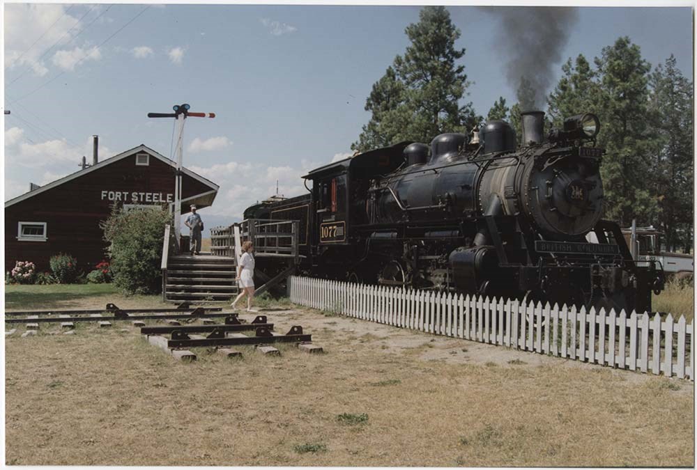
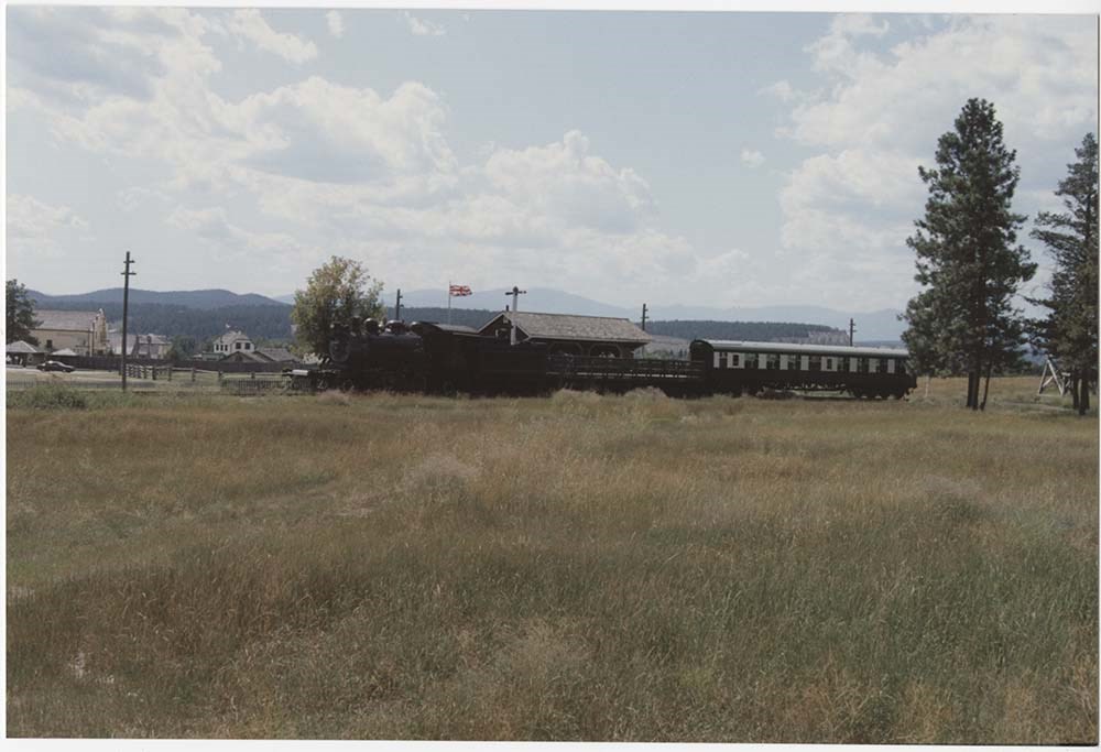
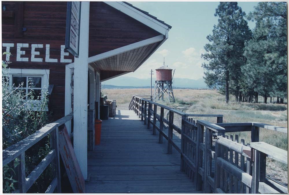
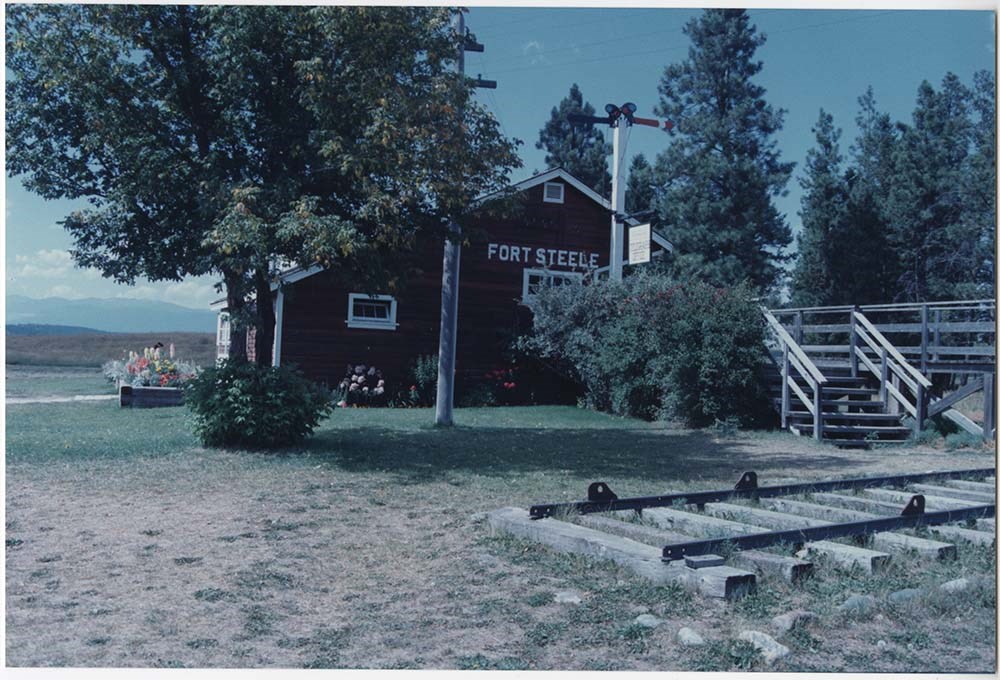
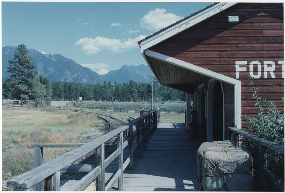
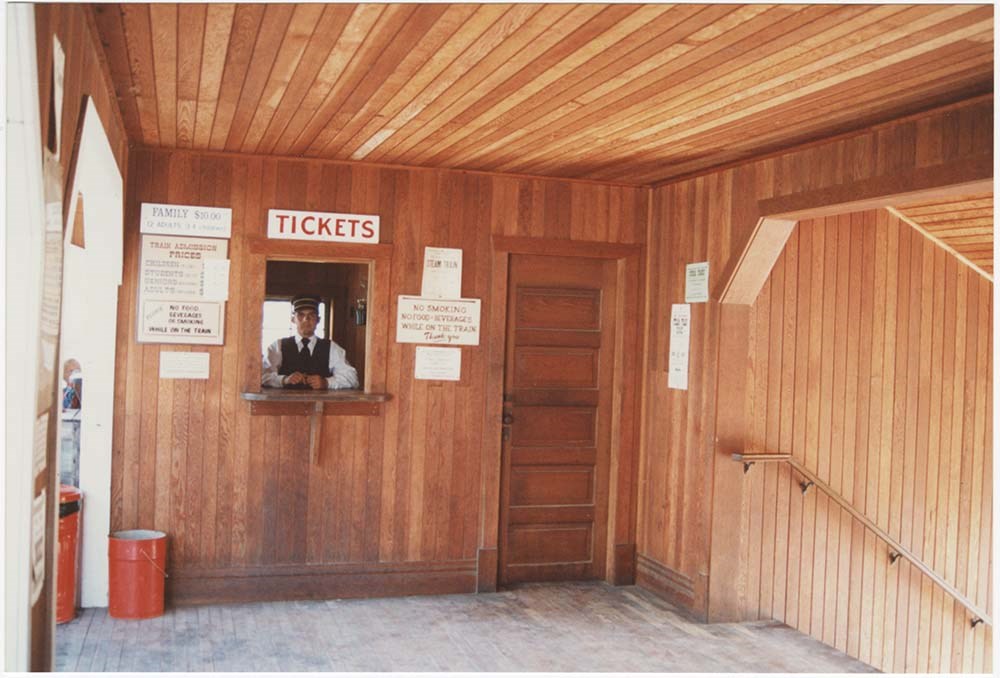
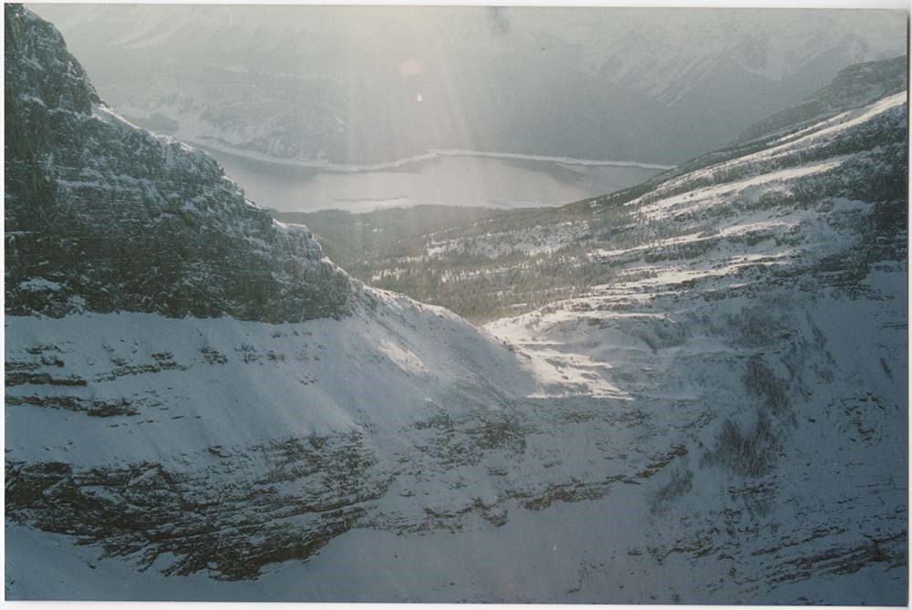
Location & Scenic [2/5]
https://archives.whyte.org/en/permalink/descriptions57136
- Part Of
- Bruno Engler fonds
- Scope & Content
- File pertains to 107 colour prints of various locations. Includes Fort Steele Locations [taken in 1991 at the same site as a 1952 shoot], wildlife, the interiors of several log houses [mostly fireplaces], the Badlands and Milk River, and various parts of Kananaskis, including Haig Glacier and Wind …
- Date Range
- 1988-1992
- Reference Code
- V190 / VI / L / v / PA - 52 to PA - 159
- Description Level
- 5 / File
- GMD
- Photograph
12 images
- Part Of
- Bruno Engler fonds
- Description Level
- 5 / File
- Fonds Number
- M323 / S40 / V190
- Series
- VI : Retained file, L : Alphabetical order
- Sous-Fonds
- V190
- Sub-Series
- v : Location & Scenic: Cliffhanger, Imax, etc
- Accession Number
- 7436
- Reference Code
- V190 / VI / L / v / PA - 52 to PA - 159
- GMD
- Photograph
- Date Range
- 1988-1992
- Physical Description
- 107 photographs : col. ; 15.2 x 10.1 cm
- History / Biographical
- See fonds level description
- Scope & Content
- File pertains to 107 colour prints of various locations. Includes Fort Steele Locations [taken in 1991 at the same site as a 1952 shoot], wildlife, the interiors of several log houses [mostly fireplaces], the Badlands and Milk River, and various parts of Kananaskis, including Haig Glacier and Wind Pass, taken from the air in 1991.
- Subject Access
- Animals
- Automobiles
- Badlands
- Buildings
- Cabins
- Filmaking
- Films and film making
- Helicopters
- Mountains
- Rivers
- Scenery
- Tourism
- Trains
- Winter
- Geographic Access
- Banff National Park
- Kananaskis Country
- Alberta
- Language
- English
- Related Material
- V190 / VI / L / v / NA - 64 to NA - 97
- Creator
- Engler, Bruno
- Title Source
- Original title kept
- Processing Status
- Processed
Images


This material is presented as originally created; it may contain outdated cultural descriptions and
potentially offensive content.
Read more.
- Part Of
- Murray Hay fonds
- Scope & Content
- File consists of 2 prints : col. ; 35 x 28 cm. File pertains to Murray Hay's rendering of Marmot Basin ski area in Jasper National Park. File includes two iterations of reproduction draft prints of Hay's map of Marmot Basin.
- Date Range
- ca.1976-ca.2000
- Reference Code
- V795 / II / B / i / 1
- Description Level
- 5 / File
- GMD
- Map
- Private record
- Part Of
- Murray Hay fonds
- Description Level
- 5 / File
- Fonds Number
- M570 / V795
- Series
- V795 / II : Unpublished Material
- Sous-Fonds
- V795
- Sub-Series
- V795 / II / B : Alberta / i : Jasper National Park
- Accession Number
- 2019.41
- Reference Code
- V795 / II / B / i / 1
- GMD
- Map
- Private record
- Date Range
- ca.1976-ca.2000
- Physical Description
- 2 prints : col. ; 35 x 28 cm
- Scope & Content
- File consists of 2 prints : col. ; 35 x 28 cm. File pertains to Murray Hay's rendering of Marmot Basin ski area in Jasper National Park. File includes two iterations of reproduction draft prints of Hay's map of Marmot Basin.
- Name Access
- Hay, Murray
- Subject Access
- Advertising
- Artist
- Ski Maps
- Ski area
- Map
- Cartography
- Sports and recreation
- Tourism
- Tourist information
- Winter
- Winter sports
- Geographic Access
- Jasper Marmot Basin
- Jasper National Park
- Alberta
- Canada
- Canadian Rocky Mountains
- Language
- English
- Related Material
- M570 / III / B / iii / 1
- Creator
- Hay, Murray
- Title Source
- Title based on contents of file
- Processing Status
- Processed
This material is presented as originally created; it may contain outdated cultural descriptions and
potentially offensive content.
Read more.
Personal Interest Files
https://archives.whyte.org/en/permalink/descriptions55796
- Part Of
- Ben Gadd fonds
- Scope & Content
- Sub-series consists of textual records and photographs collected by Ben Gadd. Content pertains to various research subjects, current events and other topics of interest, including: environmental science; wildlife; sports and recreation; Parks Canada; clubs, charities and organizations; natural hist…
- Date Range
- [ca.1980-2015]
- Reference Code
- M590 / I / C
- V810 / I / C
- Description Level
- 4 / Sub-series
- GMD
- Textual record
- Photograph
- Digital image
- Part Of
- Ben Gadd fonds
- Description Level
- 4 / Sub-series
- Fonds Number
- M590
- V810
- Series
- Series I : Personal records
- Sous-Fonds
- M590
- V810
- Sub-Series
- Subseries C : Personal Interest Files
- Accession Number
- 2021.20
- Reference Code
- M590 / I / C
- V810 / I / C
- Date Range
- [ca.1980-2015]
- Physical Description
- ca.180 cm of textual records -- 5 CDs with digital image files -- 1 floppy disk -- ca.122 photograph prints : b&w and col. -- 2 negatives : b&w ; 6 x 7.5 cm -- 26 film strips : col. negatives ; 35 mm
- Scope & Content
- Sub-series consists of textual records and photographs collected by Ben Gadd. Content pertains to various research subjects, current events and other topics of interest, including: environmental science; wildlife; sports and recreation; Parks Canada; clubs, charities and organizations; natural history; and conservation.
- Notes
- Subjects are arranged alphabetically by title. Original titles and arrangement of materials by Ben Gadd has been preserved. See file-level descriptions for content details.
- Name Access
- Gadd, Ben
- Subject Access
- Animals
- Buildings
- Buildings and facilities
- Businesses
- Boats
- Climbing
- Columbia Icefield
- Community events
- Community life
- Conservation
- Dams
- Environment
- Events
- Forestry
- Fishing
- Flowers
- Government
- Geography
- Geology
- Hiking
- History
- Ice climbing
- Land, settlement and immigration
- Landscapes
- Laws and legislation
- Membership
- Mining
- Mountaineering
- Municipal views
- Natural history
- Natural resources
- Parks Canada
- Politics and government
- Property
- Provincial parks and reserves
- Recreation
- Rivers
- Science and technology
- Settlement
- Skiing
- Snakes, Insects
- Sports
- Tourism
- Townsite development
- Trails
- Transportation
- Travel
- Wildlife
- Geographic Access
- Canada
- Alberta
- British Columbia
- United States of America
- Rocky Mountains
- Canadian Rocky Mountains
- Reproduction Restrictions
- Restrictions may apply
- Language
- English
- Category
- Commerce and industry
- Environment
- Exploration, discovery and travel
- Government
- Land, settlement and immigration
- Law and justice
- Natural resources
- Politics
- Science and technology
- Sports, recreation and leisure
- Transportation
- Title Source
- Original title used
- Processing Status
- Processed
This material is presented as originally created; it may contain outdated cultural descriptions and
potentially offensive content.
Read more.
Sunshine Village
https://archives.whyte.org/en/permalink/descriptions54991
- Part Of
- Murray Hay fonds
- Scope & Content
- File consists of 9 prints : b&w and col. ; 35 x 28 cm or smaller, 2 maps (1 base, 4 overlays) : col., annotations, on mylar ; 26 x 35 cm and 23.5 x 31.5 cm, and 1 painting : landscape ; 46 x 43 cm. File pertains to ski trail maps and landscape maps/prints of Sunshine ski area created by Murray Hay.…
- Date Range
- ca.1980-ca.1999
- Reference Code
- V795 / II / B / vi / 1-3
- Description Level
- 5 / File
- GMD
- Map
- Painting
- Private record
- Part Of
- Murray Hay fonds
- Description Level
- 5 / File
- Fonds Number
- M570 / V795
- Series
- V795 / II : Unpublished Material
- Sous-Fonds
- V795
- Sub-Series
- V795 / II / B : Alberta / vi : Sunshine Village Ski Resort
- Accession Number
- 2019.41
- Reference Code
- V795 / II / B / vi / 1-3
- Date Range
- ca.1980-ca.1999
- Physical Description
- 9 prints : b&w and col. ; 35 x 28 cm or smaller
- 2 maps (1 base, 4 overlays) : col., annotations, on mylar ; 26 x 35 cm and 23.5 x 31.5 cm
- 1 painting : landscape ; 46 x 43 cm
- Scope & Content
- File consists of 9 prints : b&w and col. ; 35 x 28 cm or smaller, 2 maps (1 base, 4 overlays) : col., annotations, on mylar ; 26 x 35 cm and 23.5 x 31.5 cm, and 1 painting : landscape ; 46 x 43 cm. File pertains to ski trail maps and landscape maps/prints of Sunshine ski area created by Murray Hay. File includes 9 reproduced draft prints (various iterations), 2 reproduced maps with overlays held together with masking tape, and 1 original painting/drawing (unfinished).
- Name Access
- Hay, Murray
- Subject Access
- Advertising
- Artist
- Ski Maps
- Ski area
- Map
- Cartography
- Sports and recreation
- Tourism
- Tourist information
- Winter
- Winter sports
- Sunshine area
- Sunshine Village
- Sunshine Ski Resort
- Geographic Access
- Sunshine
- Alberta
- Canada
- Canadian Rocky Mountains
- Banff National Park
- Language
- English
- Related Material
- M570 / III / B / i / 1-2
- Creator
- Hay, Murray
- Title Source
- Title based on contents of file
- Processing Status
- Processed
This material is presented as originally created; it may contain outdated cultural descriptions and
potentially offensive content.
Read more.
- Part Of
- Ben Gadd fonds
- Scope & Content
- File consists of photographs depicting trails and interpretive signs in William A. Switzer Provincial Park. Ben Gadd worked as a consultant for the Government of Alberta in the production of updated interpretive signs in William A. Switzer Provincial Park between 1995 and 1996.
- Date Range
- [ca.1995]
- Reference Code
- V810 / III / D / PA - 181 to 215
- Description Level
- 5 / File
- GMD
- Photograph
- Part Of
- Ben Gadd fonds
- Description Level
- 5 / File
- Fonds Number
- M590
- V810
- S61
- Series
- V810 / III : Professional records
- Sous-Fonds
- V810
- Sub-Series
- V810 / III / D : Other contracts and projects
- Accession Number
- 2021.20
- Reference Code
- V810 / III / D / PA - 181 to 215
- GMD
- Photograph
- Responsibility
- Produced by Ben Gadd
- Date Range
- [ca.1995]
- Physical Description
- 35 photographs : col. prints ; 28 x 20 cm and 15 x 10 cm
- Scope & Content
- File consists of photographs depicting trails and interpretive signs in William A. Switzer Provincial Park. Ben Gadd worked as a consultant for the Government of Alberta in the production of updated interpretive signs in William A. Switzer Provincial Park between 1995 and 1996.
- Name Access
- Gadd, Ben
- Subject Access
- Guides
- Guiding
- Provincial parks and reserves
- Government
- Recreation
- Hiking
- Environment
- Tourist information
- Geographic Access
- Canada
- Alberta
- William A. Switzer Provincial Park
- Language
- English
- Related Material
- M590/III/D/48 to 52
- V810/III/D/NA-54 to 75
- Title Source
- Original title used
- Processing Status
- Processed
This material is presented as originally created; it may contain outdated cultural descriptions and
potentially offensive content.
Read more.
West Central Alberta interpretive signs
https://archives.whyte.org/en/permalink/descriptions56327
- Part Of
- Ben Gadd fonds
- Scope & Content
- File consists of photographs depicting landscape views of west central Alberta, which were used by Ben Gadd for the production of interpretive signs. File includes several prints which were taped together to form one panoramic view.
- Date Range
- [ca.1990-1995]
- Reference Code
- V810 / III / D / PA - 19 to 38
- Description Level
- 5 / File
- GMD
- Photograph
- Part Of
- Ben Gadd fonds
- Description Level
- 5 / File
- Fonds Number
- M590
- V810
- S61
- Series
- V810 / III : Professional records
- Sous-Fonds
- V810
- Sub-Series
- V810 / III / D : Other contracts and projects
- Accession Number
- 2021.20
- Reference Code
- V810 / III / D / PA - 19 to 38
- GMD
- Photograph
- Responsibility
- Produced by Ben Gadd
- Date Range
- [ca.1990-1995]
- Physical Description
- 20 photographs : col. prints ; 29.5 x 13.5 cm and 10 x 15 cm
- Scope & Content
- File consists of photographs depicting landscape views of west central Alberta, which were used by Ben Gadd for the production of interpretive signs. File includes several prints which were taped together to form one panoramic view.
- Name Access
- Gadd, Ben
- Subject Access
- Environment
- Landscape
- Guiding
- Tourist information
- Geographic Access
- Canada
- Alberta
- Reproduction Restrictions
- Restrictions may apply
- Language
- English
- Related Material
- V810/III/D/NA-7 to 13
- Category
- Environment
- Tourism
- Title Source
- Title based on contents of file
- Processing Status
- Processed
This material is presented as originally created; it may contain outdated cultural descriptions and
potentially offensive content.
Read more.