Narrow Results By
Canadian Irrigation Surveys; A preliminary map of a portion of the foothills region from photographic and micrometer surveys by Division B; A.O. Wheeler in charge.
https://archives.whyte.org/en/permalink/catalogue23360
- Medium
- Library - Maps and blueprints (unannotated; published)
- Map
- Published Date
- 1895-6
- Publisher
- Department of the Interior
- Call Number
- C5-6.26(c)
- Publisher
- Department of the Interior
- Published Date
- 1895-6
- Physical Description
- Black and white
- Scale
- 1 1/4 miles - 1"
- Subjects
- Alberta-Irrigation
- Notes
- xerox copy
- Accession Number
- 6000
- Call Number
- C5-6.26(c)
- Collection
- Archives Library
This material is presented as originally created; it may contain outdated cultural descriptions and
potentially offensive content.
Read more.
Cart trail from Calgary to Edmonton
https://archives.whyte.org/en/permalink/catalogue24486
- Medium
- Library - Maps and blueprints (unannotated; published)
- Map
- Published Date
- 1890
- Publisher
- Dept. of the Interior
- Call Number
- C9-7.31
- Publisher
- Dept. of the Interior
- Published Date
- 1890
- Scale
- 1 mile: 2 inches
- Notes
- photostatic copy from Public Archives
- Accession Number
- 675
- Call Number
- C9-7.31
- Collection
- Archives Library
This material is presented as originally created; it may contain outdated cultural descriptions and
potentially offensive content.
Read more.
(Castle Mtn. area)
https://archives.whyte.org/en/permalink/catalogue24472
- Medium
- Library - Maps and blueprints (unannotated; published)
- Map
- Published Date
- April 26th, 1890
- Publisher
- Dominion Lands Office
- Call Number
- C9-7.25
- Publisher
- Dominion Lands Office
- Published Date
- April 26th, 1890
- Physical Description
- 1 map : col
- Scale
- 40 chains: 1 "
- Accession Number
- SG7500
- Call Number
- C9-7.25
- Collection
- Archives Library
This material is presented as originally created; it may contain outdated cultural descriptions and
potentially offensive content.
Read more.
Dominion of Canada and Newfoundland
https://archives.whyte.org/en/permalink/catalogue24550
- Medium
- Library - Maps and blueprints (unannotated; published)
- Map
- Published Date
- 1898
- Publisher
- Rand McNally and Co. Republished by the Royal Canadian Geographical Society in 1967 in recognition of Canada's Centennial
- Call Number
- C11-2.3
- Publisher
- Rand McNally and Co. Republished by the Royal Canadian Geographical Society in 1967 in recognition of Canada's Centennial
- Published Date
- 1898
- Scale
- Scale: 180 miles - 1 inch
- Subjects
- Canada
- Notes
- Duplicate in map room/Accn: 400)
- Accession Number
- 400
- 673
- Call Number
- C11-2.3
- Collection
- Archives Library
This material is presented as originally created; it may contain outdated cultural descriptions and
potentially offensive content.
Read more.
(edge of Lake Louise Forest Park)
https://archives.whyte.org/en/permalink/catalogue24485
- Medium
- Library - Maps and blueprints (unannotated; published)
- Map
- Published Date
- January 7th, 1896
- Publisher
- Department of the Interior
- Call Number
- C9-7.29
- Publisher
- Department of the Interior
- Published Date
- January 7th, 1896
- Physical Description
- 1 map : black and white
- Scale
- 40 chains: 1 inch
- Notes
- xerox copy
- Accession Number
- SG7500
- Call Number
- C9-7.29
- Collection
- Archives Library
This material is presented as originally created; it may contain outdated cultural descriptions and
potentially offensive content.
Read more.
- Medium
- Library - Maps and blueprints (unannotated; published)
- Map
- Published Date
- 1898
- Call Number
- C12-1.13
- Published Date
- 1898
- Scale
- 50 miles to 1 inch
- Subjects
- Northwestern Canada
- Notes
- four sections
- Photostatic copy from Public Archives
- Accession Number
- 675
- Call Number
- C12-1.13
- Collection
- Archives Library
This material is presented as originally created; it may contain outdated cultural descriptions and
potentially offensive content.
Read more.
(Lake Louise Forest Park)
https://archives.whyte.org/en/permalink/catalogue24484
- Medium
- Library - Maps and blueprints (unannotated; published)
- Map
- Published Date
- February 10, 1896
- Publisher
- Department of the Interior
- Call Number
- C9-7.28
- Publisher
- Department of the Interior
- Published Date
- February 10, 1896
- Physical Description
- 1 map : black and white
- Scale
- 40 chains: 1 inch
- Notes
- xerox copy
- Accession Number
- SG7500
- Call Number
- C9-7.28
- Collection
- Archives Library
This material is presented as originally created; it may contain outdated cultural descriptions and
potentially offensive content.
Read more.
Map of the Kootenay District - A mining recording divisions map
https://archives.whyte.org/en/permalink/catalogue24533
- Medium
- Library - Maps and blueprints (unannotated; published)
- Map
- Published Date
- 1897
- Publisher
- Dept. of Lands and Works, Victoria
- Call Number
- C10-6.3
- Publisher
- Dept. of Lands and Works, Victoria
- Published Date
- 1897
- Scale
- Scale: 12 miles - 1 inch
- Subjects
- Central British Columbia
- Notes
- Photostatic copy from Public Archives
- Accession Number
- 675
- Call Number
- C10-6.3
- Collection
- Archives Library
This material is presented as originally created; it may contain outdated cultural descriptions and
potentially offensive content.
Read more.
Map to illustrate system of Canadian Irrigation Surveys.
https://archives.whyte.org/en/permalink/catalogue21340
- Medium
- Library - Maps and blueprints (unannotated; published)
- Map
- Published Date
- 1896
- Publisher
- Department of the Interior
- Call Number
- C5-6.26(e)
- Publisher
- Department of the Interior
- Published Date
- 1896
- Physical Description
- Black and white
- Subjects
- Alberta-Irrigation
- Notes
- xerox copy
- Accession Number
- 6000
- Call Number
- C5-6.26(e)
- Collection
- Archives Library
This material is presented as originally created; it may contain outdated cultural descriptions and
potentially offensive content.
Read more.
Morleyville Trail and Cart Trail from Calgary to Edmonton
https://archives.whyte.org/en/permalink/catalogue24488
- Medium
- Library - Maps and blueprints (unannotated; published)
- Map
- Published Date
- 1890
- Publisher
- Dept. of the Interior
- Call Number
- C9-7.32
- Publisher
- Dept. of the Interior
- Published Date
- 1890
- Scale
- 1 mile: 2 inches
- Notes
- photostatic copy from Public Archives
- Accession Number
- 675
- Call Number
- C9-7.32
- Collection
- Archives Library
This material is presented as originally created; it may contain outdated cultural descriptions and
potentially offensive content.
Read more.
Morleyville Traill; Calgary-Edmonton Rwy.
https://archives.whyte.org/en/permalink/catalogue24489
- Medium
- Library - Maps and blueprints (unannotated; published)
- Map
- Published Date
- 1893
- Publisher
- Dept. of the Interior
- Call Number
- C9-7.33
- Publisher
- Dept. of the Interior
- Published Date
- 1893
- Scale
- 1 mile: 2 inches
- Notes
- photostatic opy from Public Archives
- Accession Number
- 675
- Call Number
- C9-7.33
- Collection
- Archives Library
This material is presented as originally created; it may contain outdated cultural descriptions and
potentially offensive content.
Read more.
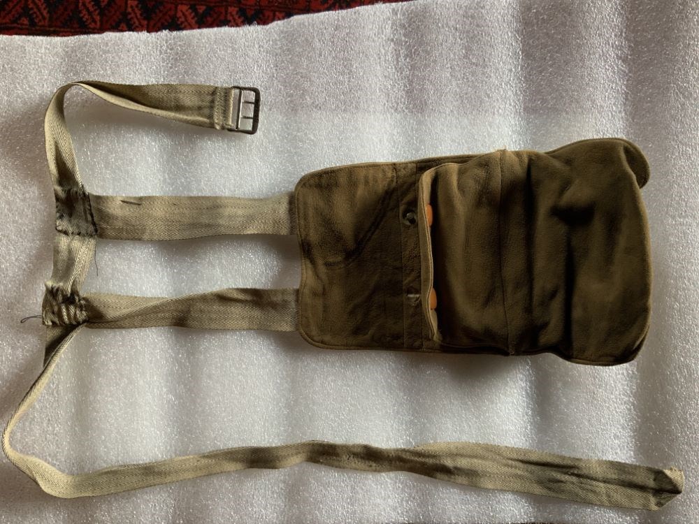
- Date
- 1890 – 1910
- Material
- metal; skin; fibre
- Catalogue Number
- 103.08.0161
- Description
- A brown suede purse which hangs by two straps from a fabric belt. There is a small money holder with a metal frame that fits inside a pocket. The money holder fastens with two snaps. The lining of the purse is stamped with a patent note.
1 image
- Title
- Purse
- Date
- 1890 – 1910
- Material
- metal; skin; fibre
- Dimensions
- 24.0 x 1.0 x 14.5 cm
- Description
- A brown suede purse which hangs by two straps from a fabric belt. There is a small money holder with a metal frame that fits inside a pocket. The money holder fastens with two snaps. The lining of the purse is stamped with a patent note.
- Subject
- tourism
- Credit
- Gift of Pearl Evelyn Moore, Banff, 1979
- Catalogue Number
- 103.08.0161
Images
This material is presented as originally created; it may contain outdated cultural descriptions and
potentially offensive content.
Read more.
Range 1, West of Fifth Meridian, Trail from Calgary to Edmonton (Railway)
https://archives.whyte.org/en/permalink/catalogue24491
- Medium
- Library - Maps and blueprints (unannotated; published)
- Map
- Published Date
- 1896
- Publisher
- Dept. of the Interior
- Call Number
- C9-7.34(a)
- Publisher
- Dept. of the Interior
- Published Date
- 1896
- Scale
- 1 mile: 2 inches
- Subjects
- Township #34
- Notes
- photostatic copy from Public Archives
- Accession Number
- 675
- Call Number
- C9-7.34(a)
- Collection
- Archives Library
This material is presented as originally created; it may contain outdated cultural descriptions and
potentially offensive content.
Read more.
Reservoir Sites A and B Canadian Irrigation Surveyrs Jumpingpound Creek from Surveys by A.O. Wheeler in 1895.
https://archives.whyte.org/en/permalink/catalogue21339
- Medium
- Library - Maps and blueprints (unannotated; published)
- Map
- Published Date
- 1896
- Publisher
- Department of the Interior
- Call Number
- C5-6.26(d)
- Publisher
- Department of the Interior
- Published Date
- 1896
- Physical Description
- Black and white
- Subjects
- Alberta-Irrigation
- Notes
- xerox copy
- Accession Number
- 6000
- Call Number
- C5-6.26(d)
- Collection
- Archives Library
This material is presented as originally created; it may contain outdated cultural descriptions and
potentially offensive content.
Read more.
[Rocky Mountains Park]
https://archives.whyte.org/en/permalink/catalogue23187
- Medium
- Library - Maps and blueprints (unannotated; published)
- Map
- Published Date
- 1890
- Publisher
- Dept. of the Interior
- Call Number
- C2-3.1a
- C2-3.1b
- C2-3.1c
- C2-3.1d
- Publisher
- Dept. of the Interior
- Published Date
- 1890
- Scale
- Scale: 1 mile to 1 inch
- Relief: Spot heights
- Subjects
- Rocky Mountains Park
- Notes
- Two duplicates in map room - Accn. 440 and 938, Two photostatic duplicates in map room - Accn. 400, One photostatic duplicate - C2-3.1b
- Accession Number
- 400
- 938
- Call Number
- C2-3.1a
- C2-3.1b
- C2-3.1c
- C2-3.1d
- Collection
- Archives Library
This material is presented as originally created; it may contain outdated cultural descriptions and
potentially offensive content.
Read more.
Silverton, Alberta
https://archives.whyte.org/en/permalink/catalogue23283
- Medium
- Library - Maps and blueprints (unannotated; published)
- Map
- Published Date
- 14th January, 1893
- Publisher
- Winnipeg : [Dept. of the Interior?]
- Call Number
- C4-2.4
- Responsibility
- George A. Bayne
- Publisher
- Winnipeg : [Dept. of the Interior?]
- Published Date
- 14th January, 1893
- Physical Description
- 1 map
- Scale
- Scale: 1 inch = 200 feet
- Subjects
- Silverton
- Notes
- 5 1/2 Section 33, Township 26, Range 14 West, 5th p.m.
- Surveyor: George A. Bayne
- Copy 2
- Accession Number
- 3001
- Call Number
- C4-2.4
- Collection
- Archives Library
This material is presented as originally created; it may contain outdated cultural descriptions and
potentially offensive content.
Read more.
- Medium
- Library - Maps and blueprints (unannotated; published)
- Map
- Published Date
- 1892
- Call Number
- C3-8.23
- Published Date
- 1892
- Subjects
- Rocky and Selkirk Mountains - B.C.
- Notes
- Photostatic copy from Public Archives
- Accession Number
- 675
- Call Number
- C3-8.23
- Collection
- Archives Library
This material is presented as originally created; it may contain outdated cultural descriptions and
potentially offensive content.
Read more.
Sketch showing the proposed method of diverting water from the Elbow River into the North Fork of Fish Creek
https://archives.whyte.org/en/permalink/catalogue23358
- Medium
- Library - Maps and blueprints (unannotated; published)
- Map
- Published Date
- 1894
- Publisher
- Department of the Interior
- Call Number
- C5-6.26(a)
- Publisher
- Department of the Interior
- Published Date
- 1894
- Physical Description
- Black and white
- Scale
- 1" :1 mile
- Subjects
- Alberta-Irrigation
- Notes
- Xerox copy
- Accession Number
- 6000
- Call Number
- C5-6.26(a)
- Collection
- Archives Library
This material is presented as originally created; it may contain outdated cultural descriptions and
potentially offensive content.
Read more.
Topographic Sheet
https://archives.whyte.org/en/permalink/catalogue24642
- Medium
- Library - Maps and blueprints (unannotated; published)
- Map
- Published Date
- 1892
- Publisher
- Dept. of the Interior
- Call Number
- C3-8.2
- Publisher
- Dept. of the Interior
- Published Date
- 1892
- Scale
- Scale: 1:40,000
- Relief: Contour interval 100 ft.
- Subjects
- Baker Creek
- Accession Number
- 675
- Call Number
- C3-8.2
- Collection
- Archives Library
This material is presented as originally created; it may contain outdated cultural descriptions and
potentially offensive content.
Read more.
Topographical sheet
https://archives.whyte.org/en/permalink/catalogue24643
- Medium
- Library - Maps and blueprints (unannotated; published)
- Map
- Published Date
- 1892
- Publisher
- Dept. of the Interior
- Call Number
- C3-8.3
- Publisher
- Dept. of the Interior
- Published Date
- 1892
- Scale
- Scale: 1:40,000
- Relief: Contour interval 100 ft.
- Subjects
- Sawback
- Notes
- Photostatic copy from Public Archives
- Accession Number
- 675
- Call Number
- C3-8.3
- Collection
- Archives Library
This material is presented as originally created; it may contain outdated cultural descriptions and
potentially offensive content.
Read more.