Narrow Results By
- Malcolm Geddes fonds 352
- Mary Schaffer fonds 28
- Moore family fonds 18
- Alpine Club of Canada fonds 8
- Leonard Leacock fonds 6
- Caroline Hinman fonds 5
- Byron Harmon fonds 4
- Archives General File Collection 2
- Bob Hind fonds 2
- Canadian Pacific Railway fonds 2
- Dan and Mary McCowan fonds 1
- Jean A. Hembroff MacDonald fonds 1
- Department of the Interior, Natural Resources Intelligence Branch 72
- Department of the Interior, Natural Resources Intelligence Service 13
- Alpine Club of Canada 12
- Charles Potter - 16 Adelaide West - Toronto 11
- Leacock, Leonard 6
- Asahel Curtis, Commercial Photographer, 625 Colman Block, Seattle, Washington 5
- Canadian National Railways 5
- Coloured by Chas. Mahon, 375 St.Catherine St. West, Montreal, Que. 5
- Hinman, Caroline 5
- Canadian Pacific Railway 4
- Harmon, Byron 4
- Graystone Bird, Bath, UK 3
[A. O. Wheeler]
https://archives.whyte.org/en/permalink/descriptions43363
- Part Of
- Malcolm Geddes fonds
- Scope & Content
- Lantern slide depicts Arthur O. Wheeler posing with a cape and hat, with mountains visible in the background.
- Date Range
- [ca.1913-ca.1925]
- Reference Code
- V756 / III / A / PS - 121
- Description Level
- 6 / Item
- GMD
- Photograph
- Lantern slide
1 image
- Part Of
- Malcolm Geddes fonds
- Description Level
- 6 / Item
- Fonds Number
- M39 / V756
- Series
- V756 / III : Personal and family records
- Sous-Fonds
- V756
- Accession Number
- 6504
- Reference Code
- V756 / III / A / PS - 121
- Date Range
- [ca.1913-ca.1925]
- Physical Description
- 1 photograph : b&w transparency (lantern slide)
- Scope & Content
- Lantern slide depicts Arthur O. Wheeler posing with a cape and hat, with mountains visible in the background.
- Name Access
- Wheeler, A. O. (Arthur Oliver)
- Access Restrictions
- Fragile- restrictions may apply
- Reproduction Restrictions
- Fragile- restrictions may apply
- Language
- N/A
- Title Source
- Title based on contents of file
- Processing Status
- Processed
Images

This material is presented as originally created; it may contain outdated cultural descriptions and
potentially offensive content.
Read more.
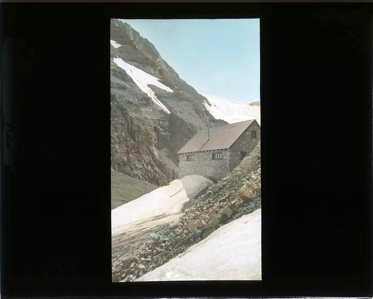
Abbot Pass Hut
https://archives.whyte.org/en/permalink/descriptions43267
- Part Of
- Malcolm Geddes fonds
- Scope & Content
- Lantern slide depicts a side view of Abbot Pass Hut.
- Date Range
- [ca.1922-ca.1925]
- Reference Code
- V756 / III / A / PS - 25
- Description Level
- 6 / Item
- GMD
- Photograph
- Lantern slide
1 image
- Part Of
- Malcolm Geddes fonds
- Description Level
- 6 / Item
- Fonds Number
- M39 / V756
- Series
- V756 / III : Personal and family records
- Sous-Fonds
- V756
- Accession Number
- 6504
- Reference Code
- V756 / III / A / PS - 25
- Date Range
- [ca.1922-ca.1925]
- Physical Description
- 1 photograph : transparency (lantern slide)
- History / Biographical
- Abbot Pass Hut was constructed by the Alpine Club of Canada in 1922 and is located at 2,926 metres elevation, between Mt. Lefroy and Mt. Victoria. The hut is positioned directly on top of the Great Divide [Alberta and British Columbia border].
- Scope & Content
- Lantern slide depicts a side view of Abbot Pass Hut.
- Notes
- Slide is hand-coloured.
- Material Details
- Individual labels: rectangular red label #12; remains of a white label "Alpine ---"
- Inscription visible on back of slide: Nov 20 7845
- Name Access
- Alpine Club of Canada
- Geographic Access
- Abbot Pass
- Access Restrictions
- Fragile- restrictions may apply
- Reproduction Restrictions
- Fragile- restrictions may apply
- Language
- N/A
- Category
- Exploration, discovery and travel
- Biographical Source Notes
- https://www.alpineclubofcanada.ca/web/ACCMember/Huts/Abbot_Pass_Hut.aspx
- Title Source
- Title based on contents of file
- Processing Status
- Processed
Images
This material is presented as originally created; it may contain outdated cultural descriptions and
potentially offensive content.
Read more.
[Abruzzi, Mount 82J/6 East, B.C.]
https://archives.whyte.org/en/permalink/catalogue23438
- Medium
- Library - Maps and blueprints (unannotated; published)
- Map
- Published Date
- 1966
- Publisher
- Dept. of Mines and Technical Surveys
- Call Number
- NTS
- 82J/6E
- Publisher
- Dept. of Mines and Technical Surveys
- Published Date
- 1966
- Physical Description
- 1 map : col
- Scale
- Scale: 1:50,000
- Relief: Contour interval 100'
- Subjects
- Mount Abruzzi
- British Columbia
- Notes
- National Topographic System
- Accession Number
- 718
- Call Number
- NTS
- 82J/6E
- Collection
- Archives Library
This material is presented as originally created; it may contain outdated cultural descriptions and
potentially offensive content.
Read more.
[Abruzzi, Mount 82J/6 West, B.C.]
https://archives.whyte.org/en/permalink/catalogue23437
- Medium
- Library - Maps and blueprints (unannotated; published)
- Map
- Published Date
- 1966
- Publisher
- Dept. of Mines and Technical Surveys
- Call Number
- NTS
- 82J/6W
- Publisher
- Dept. of Mines and Technical Surveys
- Published Date
- 1966
- Physical Description
- 1 map : col
- Scale
- Scale: 1:50,000
- Relief: Contour interval 100'
- Subjects
- Mount Abruzzi
- British Columbia
- Notes
- National Topographic System
- Accession Number
- 718
- Call Number
- NTS
- 82J/6W
- Collection
- Archives Library
This material is presented as originally created; it may contain outdated cultural descriptions and
potentially offensive content.
Read more.
ACC group camp
https://archives.whyte.org/en/permalink/descriptions43327
- Part Of
- Malcolm Geddes fonds
- Scope & Content
- Lantern slide depicts a large group of hikers seated around a fire pit with tents set up in the background.
- Date Range
- [ca.1913-ca.1925]
- Reference Code
- V756 / III / A / PS - 85
- Description Level
- 6 / Item
- GMD
- Photograph
- Lantern slide
1 image
- Part Of
- Malcolm Geddes fonds
- Description Level
- 6 / Item
- Fonds Number
- M39 / V756
- Series
- V756 / III : Personal and family records
- Sous-Fonds
- V756
- Accession Number
- 6504
- Reference Code
- V756 / III / A / PS - 85
- Date Range
- [ca.1913-ca.1925]
- Physical Description
- 1 photograph : transparency (lantern slide)
- Scope & Content
- Lantern slide depicts a large group of hikers seated around a fire pit with tents set up in the background.
- Notes
- Slide is hand-coloured.
- Access Restrictions
- Fragile- restrictions may apply
- Reproduction Restrictions
- Fragile- restrictions may apply
- Language
- N/A
- Title Source
- Title based on contents of file
- Processing Status
- Processed
Images

This material is presented as originally created; it may contain outdated cultural descriptions and
potentially offensive content.
Read more.
[Adams Lookout, Alberta]
https://archives.whyte.org/en/permalink/catalogue23439
- Medium
- Library - Maps and blueprints (unannotated; published)
- Map
- Published Date
- 1962
- Publisher
- Dept. of Mines & Technical Surveys
- Call Number
- NTS
- 83E/10E
- Publisher
- Dept. of Mines & Technical Surveys
- Published Date
- 1962
- Scale
- Scale: 1:50,000
- Subjects
- Adams Lookout
- Alberta
- Notes
- National Topographic System
- Accession Number
- 12000
- Call Number
- NTS
- 83E/10E
- Collection
- Archives Library
This material is presented as originally created; it may contain outdated cultural descriptions and
potentially offensive content.
Read more.
[Adams Lookout, Alberta]
https://archives.whyte.org/en/permalink/catalogue23440
- Medium
- Library - Maps and blueprints (unannotated; published)
- Map
- Published Date
- 1962
- Publisher
- Dept. of Mines and Technical Surveys
- Call Number
- NTS
- 83W/10W
- Publisher
- Dept. of Mines and Technical Surveys
- Published Date
- 1962
- Scale
- Scale: 1:50,000
- Subjects
- Adams Lookout
- Alberta
- Notes
- National Topographic System
- Accession Number
- 12000
- Call Number
- NTS
- 83W/10W
- Collection
- Archives Library
This material is presented as originally created; it may contain outdated cultural descriptions and
potentially offensive content.
Read more.
[Adams Plateau 82M/4 East, B.C.]
https://archives.whyte.org/en/permalink/catalogue23441
- Medium
- Library - Maps and blueprints (unannotated; published)
- Map
- Published Date
- 1961
- Publisher
- Department of Mines and Technical Surveys
- Call Number
- NTS
- 82M/4E
- Publisher
- Department of Mines and Technical Surveys
- Published Date
- 1961
- Physical Description
- 1 map : col
- Scale
- Scale: 1:50,000
- Relief: Contour interval 100 ft.
- Subjects
- Adams Plateau
- British Columbia
- Notes
- National Topographic System
- Accession Number
- 7000
- Call Number
- NTS
- 82M/4E
- Collection
- Archives Library
This material is presented as originally created; it may contain outdated cultural descriptions and
potentially offensive content.
Read more.
[Adams Plateau 82M/4 West, B.C.]
https://archives.whyte.org/en/permalink/catalogue23442
- Medium
- Library - Maps and blueprints (unannotated; published)
- Map
- Published Date
- 1961
- Publisher
- Department of Mines and Technical Surveys
- Call Number
- NTS
- 82M/4W
- Publisher
- Department of Mines and Technical Surveys
- Published Date
- 1961
- Physical Description
- 1 map : col
- Scale
- Scale: 1:50,000
- Relief: Contour interval 100 ft.
- Subjects
- Adams Plateau
- British Columbia
- Notes
- National Topographic System
- Accession Number
- 7000
- Call Number
- NTS
- 82M/4W
- Collection
- Archives Library
This material is presented as originally created; it may contain outdated cultural descriptions and
potentially offensive content.
Read more.
[Adams River 82M/11 East, B.C.]
https://archives.whyte.org/en/permalink/catalogue23443
- Medium
- Library - Maps and blueprints (unannotated; published)
- Map
- Published Date
- 1961
- Publisher
- Dept. of Mines and Technical Surveys
- Call Number
- NTS
- 82M/11E
- Publisher
- Dept. of Mines and Technical Surveys
- Published Date
- 1961
- Physical Description
- 1 map : col
- Scale
- Scale: 1:50,000
- Relief: Contour interval 100 ft.
- Subjects
- Adams River
- British Columbia
- Notes
- National Topographic System
- Accession Number
- 3000
- Call Number
- NTS
- 82M/11E
- Collection
- Archives Library
This material is presented as originally created; it may contain outdated cultural descriptions and
potentially offensive content.
Read more.
[Adams River 82M/11 West, B.C.]
https://archives.whyte.org/en/permalink/catalogue23444
- Medium
- Library - Maps and blueprints (unannotated; published)
- Map
- Published Date
- 1961
- Publisher
- Dept. of Mines and Technical Surveys
- Call Number
- NTS
- 82M/11W
- Publisher
- Dept. of Mines and Technical Surveys
- Published Date
- 1961
- Physical Description
- 1 map : col
- Scale
- Scale: 1:50,000
- Relief: Contour interval 100 ft.
- Subjects
- Adams River
- British Columbia
- Notes
- National Topographic System
- Accession Number
- 3000
- Call Number
- NTS
- 82M/11W
- Collection
- Archives Library
This material is presented as originally created; it may contain outdated cultural descriptions and
potentially offensive content.
Read more.
- Medium
- Library - Maps and blueprints (unannotated; published)
- Map
- Published Date
- 1922
- Publisher
- National Geographic Society
- Call Number
- C13-7.1
- Publisher
- National Geographic Society
- Published Date
- 1922
- Scale
- 1" = 185 miles
- Subjects
- Africa
- Notes
- there is a duplicate
- Accession Number
- 400
- 576
- Call Number
- C13-7.1
- Collection
- Archives Library
This material is presented as originally created; it may contain outdated cultural descriptions and
potentially offensive content.
Read more.
[Africa, Northwestern]
https://archives.whyte.org/en/permalink/catalogue24841
- Medium
- Library - Maps and blueprints (unannotated; published)
- Map
- Published Date
- 1966
- Publisher
- National Geographic Society
- Call Number
- C13-7.3
- Publisher
- National Geographic Society
- Published Date
- 1966
- Scale
- Scale: 125 miles to 1 inch
- Relief: Bench marks
- Subjects
- Northwestern Africa
- Call Number
- C13-7.3
- Collection
- Archives Library
This material is presented as originally created; it may contain outdated cultural descriptions and
potentially offensive content.
Read more.
[Africa, Southern]
https://archives.whyte.org/en/permalink/catalogue24840
- Medium
- Library - Maps and blueprints (unannotated; published)
- Map
- Published Date
- 1962
- Publisher
- National Geographic Society
- Call Number
- C13-7.2
- Publisher
- National Geographic Society
- Published Date
- 1962
- Scale
- Scale: 125 miles to 1 inch
- Relief: bench marks
- Subjects
- Southern Africa
- Accession Number
- 495
- Call Number
- C13-7.2
- Collection
- Archives Library
This material is presented as originally created; it may contain outdated cultural descriptions and
potentially offensive content.
Read more.
[Albas 82M/3 East, B.C.]
https://archives.whyte.org/en/permalink/catalogue23445
- Medium
- Library - Maps and blueprints (unannotated; published)
- Map
- Published Date
- 1961
- Publisher
- Dept. of Mines and Technical Surveys
- Call Number
- NTS
- 82M/3E
- Publisher
- Dept. of Mines and Technical Surveys
- Published Date
- 1961
- Physical Description
- 1 map : black and white
- Scale
- Scale: 1:50,000
- Relief: Contour interval 100 ft.
- Subjects
- Albas
- British Columbia
- Notes
- National Topographic System
- Accession Number
- 3000
- Call Number
- NTS
- 82M/3E
- Collection
- Archives Library
This material is presented as originally created; it may contain outdated cultural descriptions and
potentially offensive content.
Read more.
[Albas 82M/3 West, B.C.]
https://archives.whyte.org/en/permalink/catalogue23446
- Medium
- Library - Maps and blueprints (unannotated; published)
- Map
- Published Date
- 1961
- Publisher
- Dept. of Mines and Technical Surveys
- Call Number
- NTS
- 82M/3W
- Publisher
- Dept. of Mines and Technical Surveys
- Published Date
- 1961
- Physical Description
- 1 map : black and white
- Scale
- Scale: 1:50,000
- Relief: Contour interval 100 ft.
- Subjects
- Albas
- British Columbia
- Notes
- National Topographic System
- Accession Number
- 3000
- Call Number
- NTS
- 82M/3W
- Collection
- Archives Library
This material is presented as originally created; it may contain outdated cultural descriptions and
potentially offensive content.
Read more.
- Medium
- Library - Maps and blueprints (unannotated; published)
- Map
- Published Date
- 1927
- Publisher
- Dept. of the Interior, Ottawa
- Call Number
- C9-1.2
- Publisher
- Dept. of the Interior, Ottawa
- Published Date
- 1927
- Physical Description
- 1 map: col
- Scale
- Scale: 12 1/2 miles: 1 inch
- Subjects
- Alberta
- Accession Number
- 400
- Call Number
- C9-1.2
- Collection
- Archives Library
This material is presented as originally created; it may contain outdated cultural descriptions and
potentially offensive content.
Read more.
[Alberta] 2 sections
https://archives.whyte.org/en/permalink/catalogue24382
- Medium
- Library - Maps and blueprints (unannotated; published)
- Map
- Published Date
- 1965
- Publisher
- Dept. of Highways, Alberta
- Call Number
- C9-1.3(a)
- Publisher
- Dept. of Highways, Alberta
- Published Date
- 1965
- Physical Description
- 1 map : col
- Scale
- Scale: 12 miles: 1 inch
- Accession Number
- 673
- Call Number
- C9-1.3(a)
- Collection
- Archives Library
This material is presented as originally created; it may contain outdated cultural descriptions and
potentially offensive content.
Read more.
[Alberta] 2 sections
https://archives.whyte.org/en/permalink/catalogue24383
- Medium
- Library - Maps and blueprints (unannotated; published)
- Map
- Published Date
- 1967
- Publisher
- Dept. of Highways, Alberta
- Call Number
- C9-1.3(b)
- Publisher
- Dept. of Highways, Alberta
- Published Date
- 1967
- Physical Description
- 1 map : col
- Scale
- Scale: 12 miles: 1 inch
- Subjects
- Alberta
- Accession Number
- 673
- Call Number
- C9-1.3(b)
- Collection
- Archives Library
This material is presented as originally created; it may contain outdated cultural descriptions and
potentially offensive content.
Read more.
[Alberta] Department of Highways and Transport District Boundaries
https://archives.whyte.org/en/permalink/catalogue21405
- Medium
- Library - Maps and blueprints (unannotated; published)
- Map
- Published Date
- 1969
- Publisher
- Surveys Branch, Department of Highways and Transport
- Call Number
- C9-5.8
- Publisher
- Surveys Branch, Department of Highways and Transport
- Published Date
- 1969
- Subjects
- Alberta
- Notes
- Legend in colour
- Accession Number
- SG7500
- Call Number
- C9-5.8
- Collection
- Archives Library
This material is presented as originally created; it may contain outdated cultural descriptions and
potentially offensive content.
Read more.