Narrow Results By
- Bruno Engler fonds 65
- Luxton family fonds 25
- Nicholas Morant fonds 18
- Peter and Catharine Whyte fonds 18
- Arthur A. Goodsell fonds 6
- Alpine Club of Canada fonds 5
- James Irving McLeod fonds 5
- Jim Brewster family fonds 4
- William Royle fonds 4
- Archives General File Collection 2
- Astley family fonds 2
- Banff School District No. 102 fonds 1
[Abruzzi, Mount 82J/6 East, B.C.]
https://archives.whyte.org/en/permalink/catalogue23438
- Medium
- Library - Maps and blueprints (unannotated; published)
- Map
- Published Date
- 1966
- Publisher
- Dept. of Mines and Technical Surveys
- Call Number
- NTS
- 82J/6E
- Publisher
- Dept. of Mines and Technical Surveys
- Published Date
- 1966
- Physical Description
- 1 map : col
- Scale
- Scale: 1:50,000
- Relief: Contour interval 100'
- Subjects
- Mount Abruzzi
- British Columbia
- Notes
- National Topographic System
- Accession Number
- 718
- Call Number
- NTS
- 82J/6E
- Collection
- Archives Library
This material is presented as originally created; it may contain outdated cultural descriptions and
potentially offensive content.
Read more.
[Abruzzi, Mount 82J/6 West, B.C.]
https://archives.whyte.org/en/permalink/catalogue23437
- Medium
- Library - Maps and blueprints (unannotated; published)
- Map
- Published Date
- 1966
- Publisher
- Dept. of Mines and Technical Surveys
- Call Number
- NTS
- 82J/6W
- Publisher
- Dept. of Mines and Technical Surveys
- Published Date
- 1966
- Physical Description
- 1 map : col
- Scale
- Scale: 1:50,000
- Relief: Contour interval 100'
- Subjects
- Mount Abruzzi
- British Columbia
- Notes
- National Topographic System
- Accession Number
- 718
- Call Number
- NTS
- 82J/6W
- Collection
- Archives Library
This material is presented as originally created; it may contain outdated cultural descriptions and
potentially offensive content.
Read more.
- Part Of
- Bruno Engler fonds
- Scope & Content
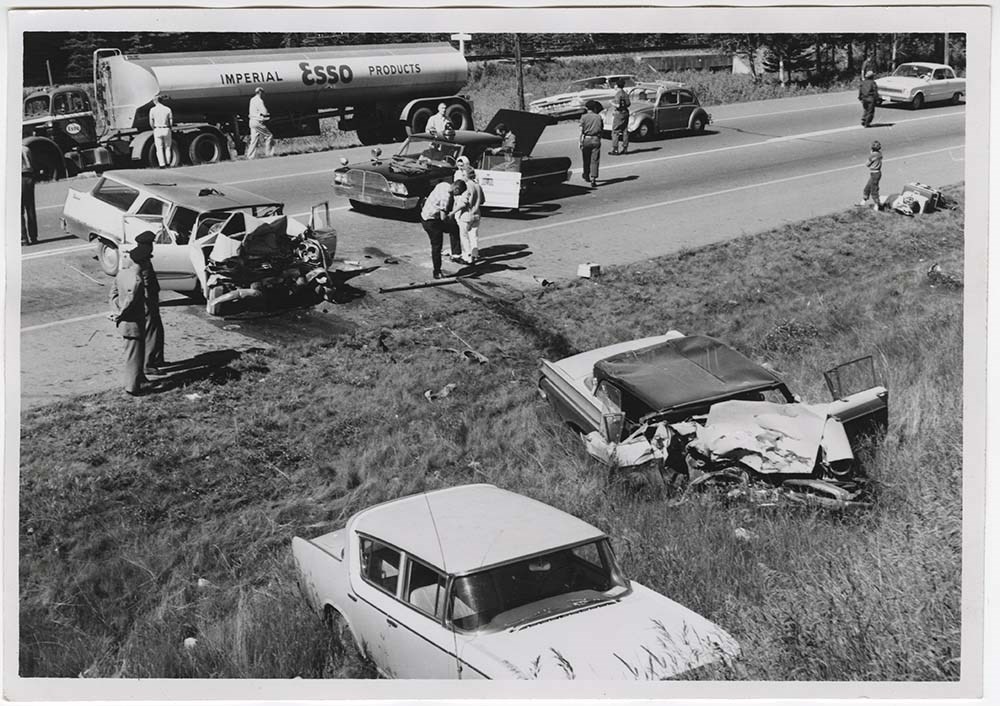
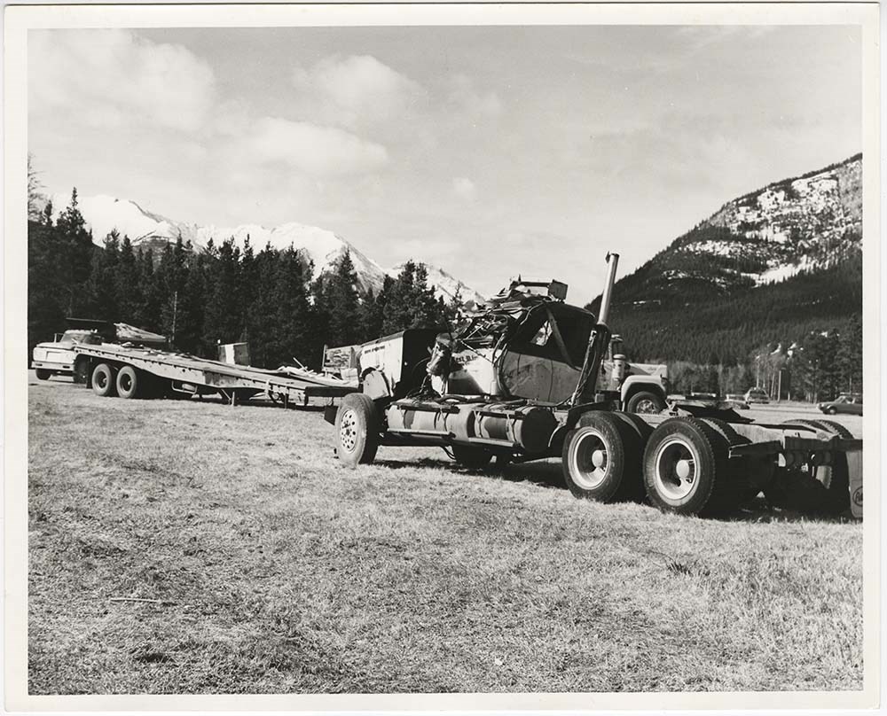
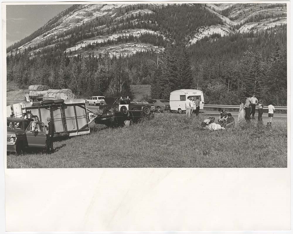
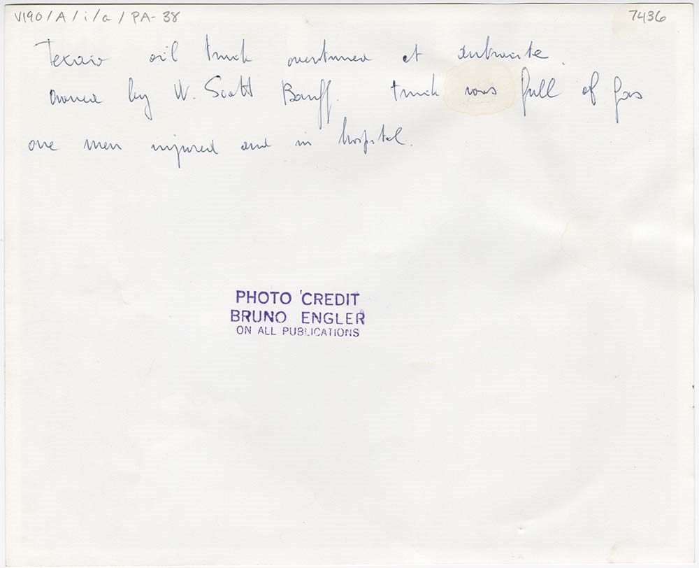
- File pertains to 43 b&w prints of various accidents around Banff National Park and the Banff townsite. Includes car collisions, train derailments, a small plane crash, and the Banff Bus Depot fire.
- Date Range
- [ca. 1962-1970]
- Reference Code
- V190 / VI / A / i / a / PA - 01 to PA - 43
- Description Level
- 5 / File
- GMD
- Photograph print
11 images
- Part Of
- Bruno Engler fonds
- Description Level
- 5 / File
- Fonds Number
- M323 / S40 / V190
- Series
- VI : Retained file, A : Alphabetical order
- Sous-Fonds
- V190
- Sub-Series
- i : Accidents
- Accession Number
- 7436
- Reference Code
- V190 / VI / A / i / a / PA - 01 to PA - 43
- Date Range
- [ca. 1962-1970]
- Physical Description
- 43 photographs : b&w ; 25.5 x 20.5 cm or smaller
- History / Biographical
- See fonds level description
- Scope & Content
- File pertains to 43 b&w prints of various accidents around Banff National Park and the Banff townsite. Includes car collisions, train derailments, a small plane crash, and the Banff Bus Depot fire.
- Notes
- Caution: some images include disturbing content, viewer discretion is advised.
- Name Access
- Engler, Bruno
- Subject Access
- Airplanes
- Automobiles
- Banff townsite
- Buildings
- Businesses
- Fire
- Trains
- Geographic Access
- Banff
- Banff National Park
- Alberta
- Language
- English
- Creator
- Engler, Bruno
- Title Source
- Original title kept
- Processing Status
- Processed
Images


This material is presented as originally created; it may contain outdated cultural descriptions and
potentially offensive content.
Read more.
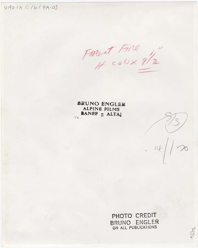
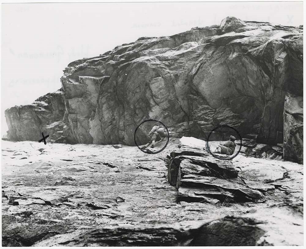
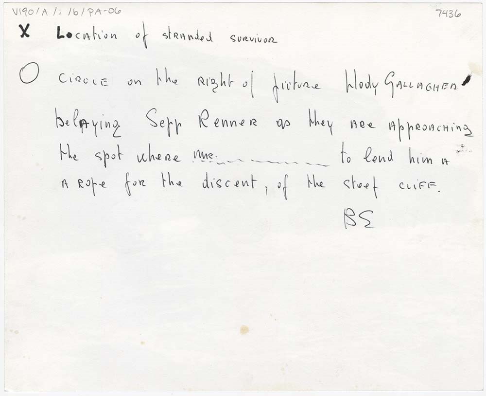
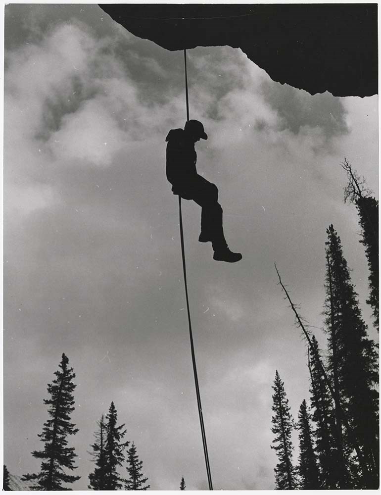
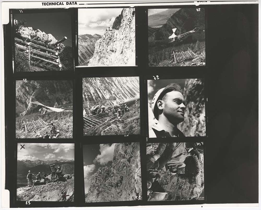
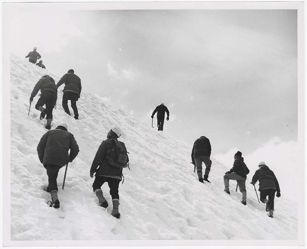
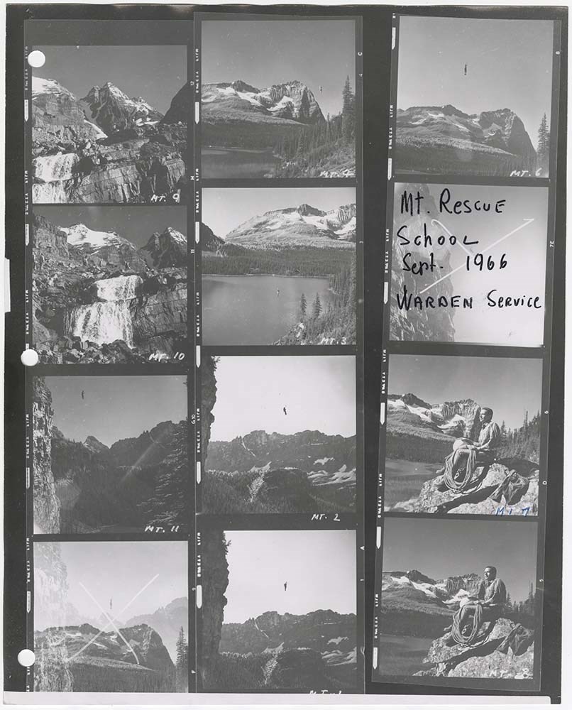
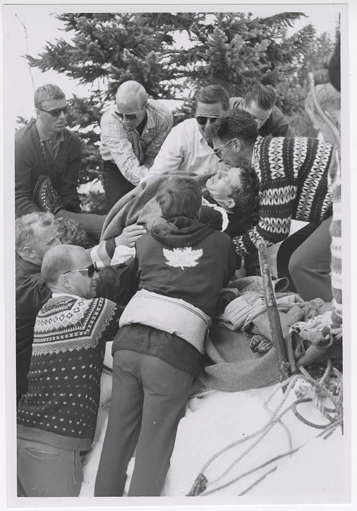
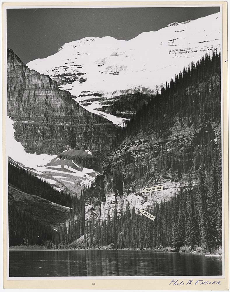
Accidents - Rescues
https://archives.whyte.org/en/permalink/descriptions56696
- Part Of
- Bruno Engler fonds
- Scope & Content
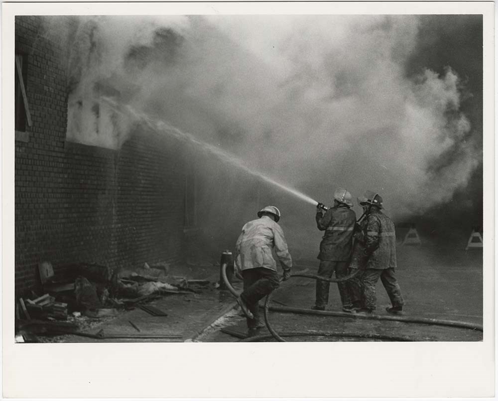
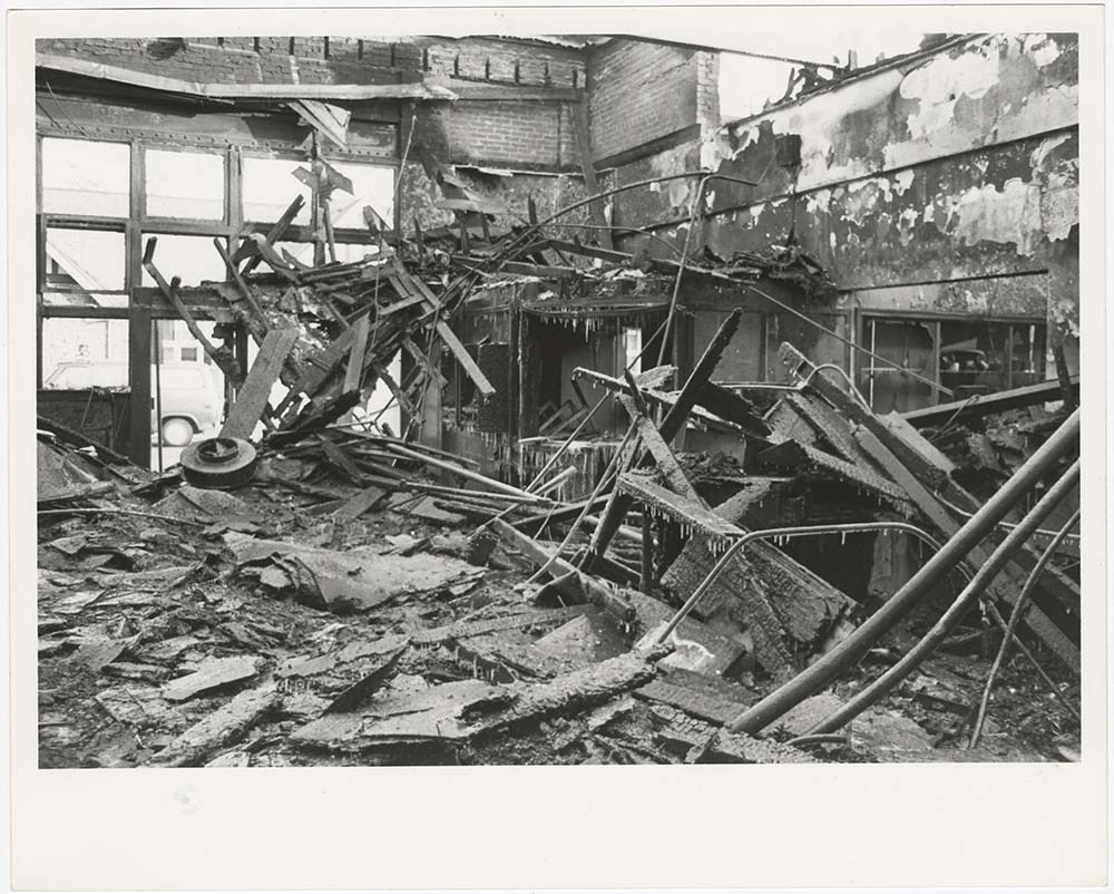
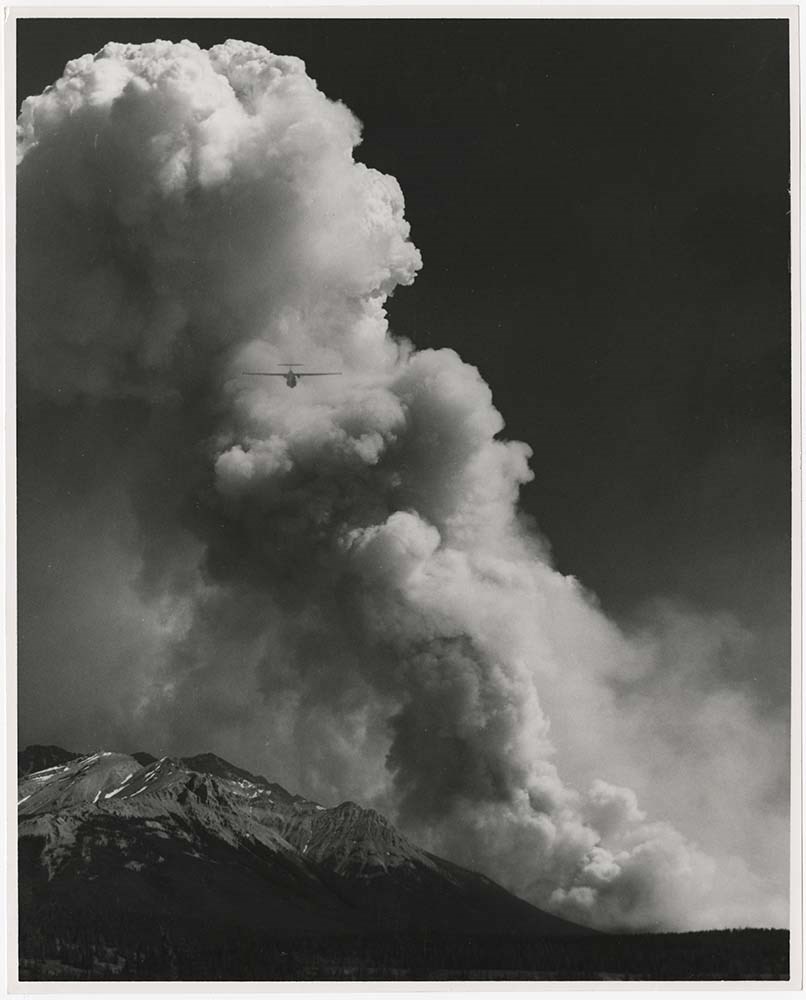
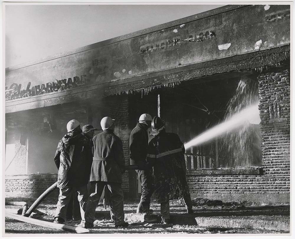
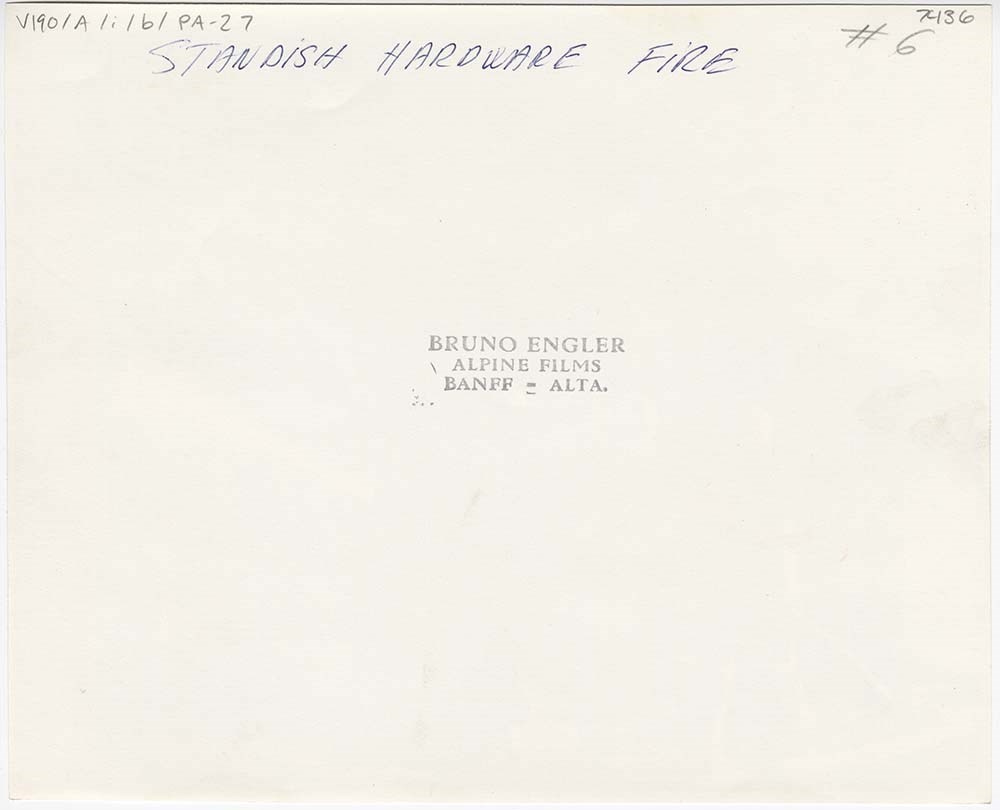
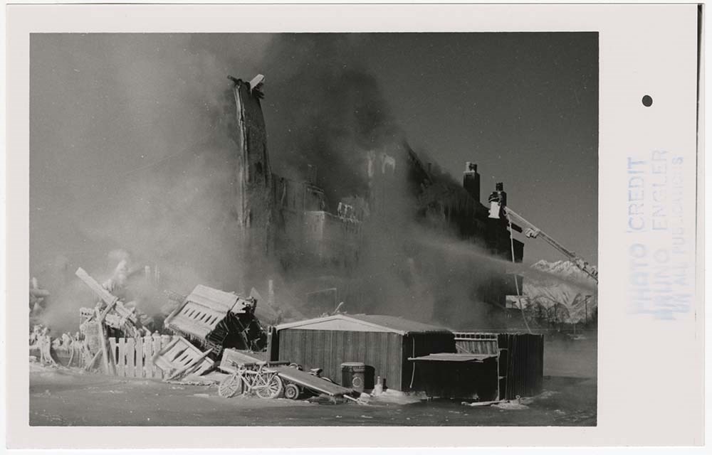
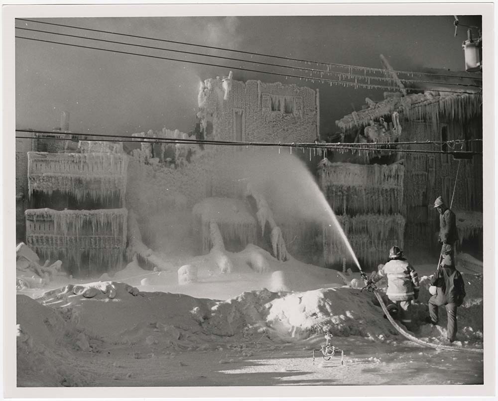
- File pertains to 51 b&w prints of various accidents and rescue missions around Banff National Park and the Banff townsite. Includes a forest fire, the Standish Hardware store fire, skiing rescue missions, and climbing/mountaineering rescue missions.
- Date Range
- [ca. 1962-1970]
- Reference Code
- V190 / VI / A / i / b / PA - 01 to PA - 51
- Description Level
- 5 / File
- GMD
- Photograph print
16 images
- Part Of
- Bruno Engler fonds
- Description Level
- 5 / File
- Fonds Number
- M323 / S40 / V190
- Series
- VI : Retained file, A : Alphabetical order
- Sous-Fonds
- V190
- Sub-Series
- i : Accidents
- Accession Number
- 7436
- Reference Code
- V190 / VI / A / i / b / PA - 01 to PA - 51
- Date Range
- [ca. 1962-1970]
- Physical Description
- 51 photographs : b&w ; 25.5 x 20.5 cm or smaller
- History / Biographical
- See fonds level description
- Scope & Content
- File pertains to 51 b&w prints of various accidents and rescue missions around Banff National Park and the Banff townsite. Includes a forest fire, the Standish Hardware store fire, skiing rescue missions, and climbing/mountaineering rescue missions.
- Notes
- Caution: some images include disturbing content, viewer discretion is advised.
- Name Access
- Engler, Bruno
- Gallagher, Lloyd (Kiwi)
- Subject Access
- Airplanes
- Automobiles
- Buildings
- Businesses
- Climbing
- Fire
- Helicopters
- Mountains
- Mountaineering
- Mountaineers
- Skiing
- Geographic Access
- Banff
- Banff National Park
- Alberta
- Language
- English
- Creator
- Engler, Bruno
- Title Source
- Original title kept
- Processing Status
- Processed
Images


This material is presented as originally created; it may contain outdated cultural descriptions and
potentially offensive content.
Read more.
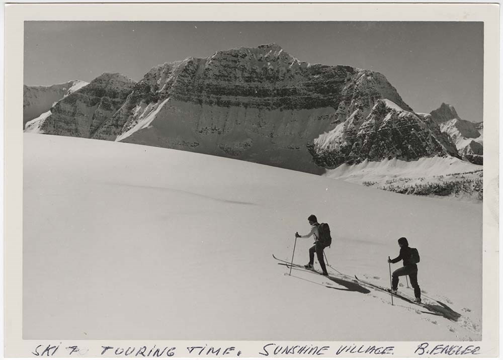
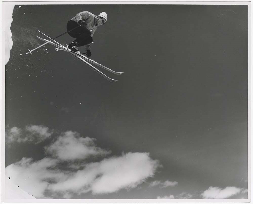
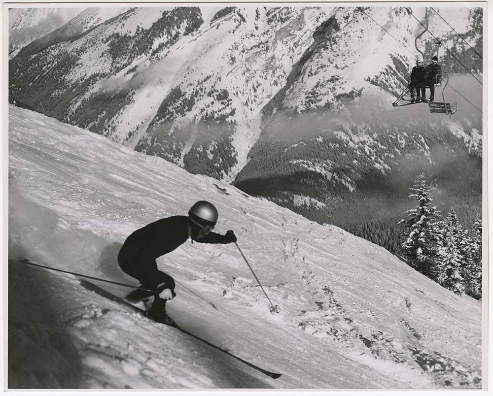
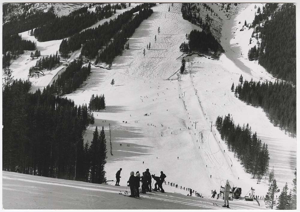
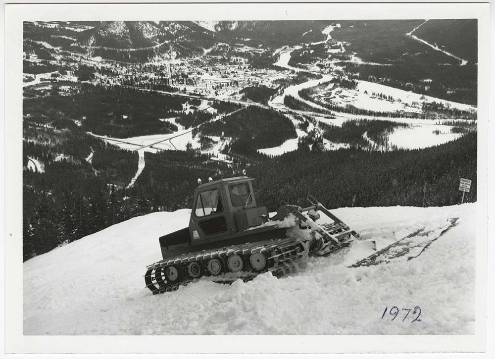
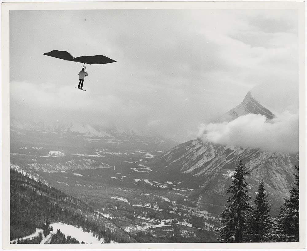
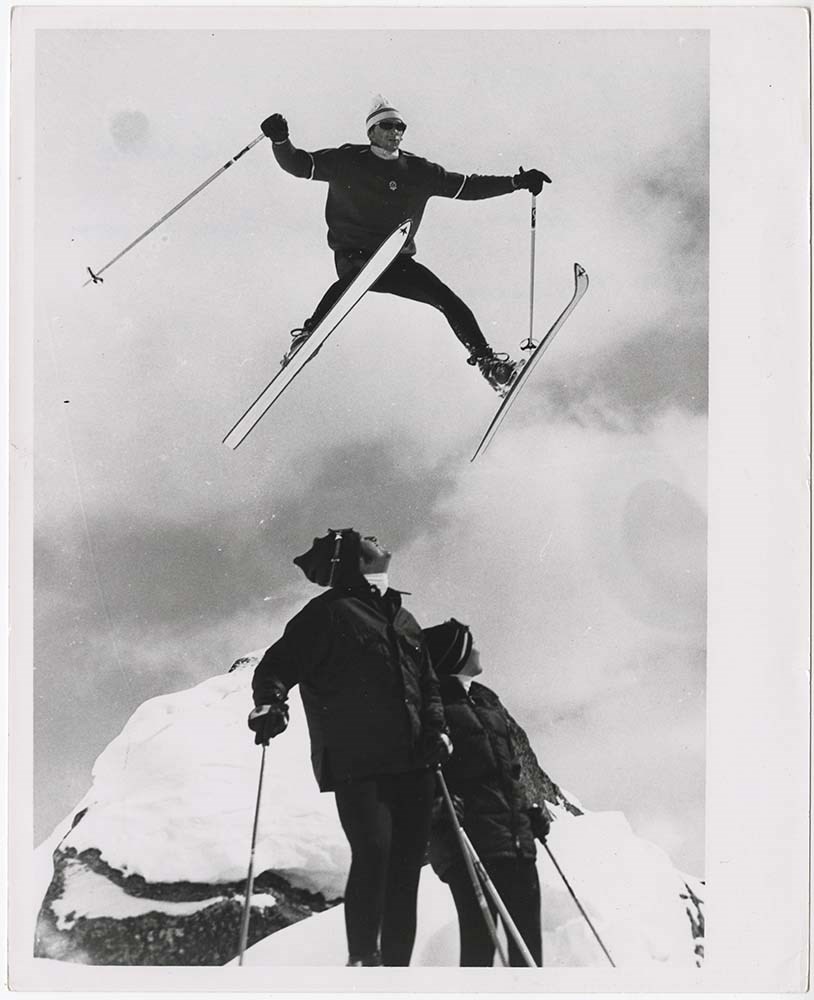
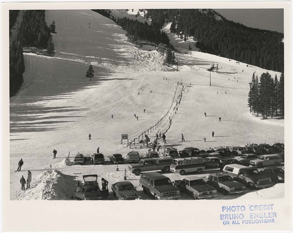
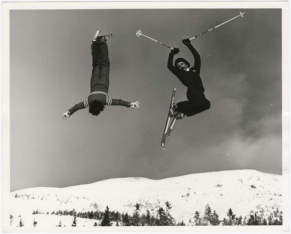
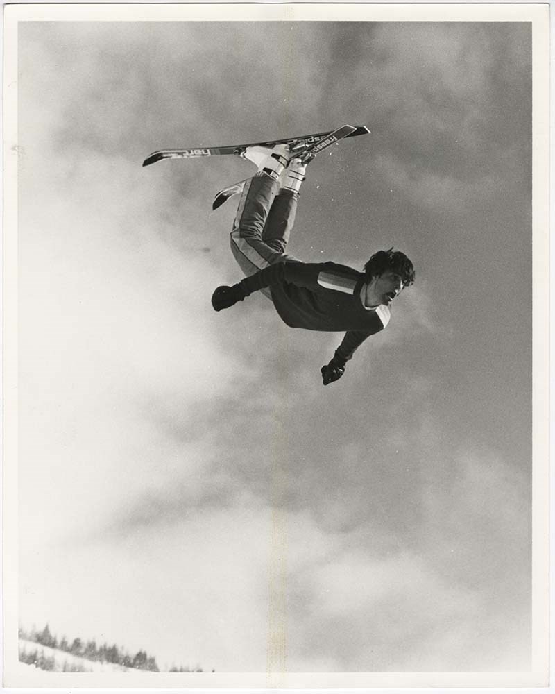
Action on Skis
https://archives.whyte.org/en/permalink/descriptions56697
- Part Of
- Bruno Engler fonds
- Scope & Content
- File pertains to 38 b&w prints of people skiing. Includes action shots of people skiing at Norquay, Lake Louise, and Sunshine, the Norquay parking lot, ski jumping, ski racing, and an unidentified person paragliding on skis at Norquay.
- Date Range
- [ca. 1948-1980]
- Reference Code
- V190 / VI / A / ii / PA - 01 to PA - 38
- Description Level
- 5 / File
- GMD
- Photograph print
12 images
- Part Of
- Bruno Engler fonds
- Description Level
- 5 / File
- Fonds Number
- M323 / S40 / V190
- Series
- VI : Retained file, A : Alphabetical order
- Sous-Fonds
- V190
- Sub-Series
- ii : Action on Skis
- Accession Number
- 7436
- Reference Code
- V190 / VI / A / ii / PA - 01 to PA - 38
- Date Range
- [ca. 1948-1980]
- Physical Description
- 38 photographs : b&w ; 25.5 x 20.5 cm or smaller
- History / Biographical
- See fonds level description
- Scope & Content
- File pertains to 38 b&w prints of people skiing. Includes action shots of people skiing at Norquay, Lake Louise, and Sunshine, the Norquay parking lot, ski jumping, ski racing, and an unidentified person paragliding on skis at Norquay.
- Name Access
- Engler, Bruno
- Subject Access
- Activities
- Lake Louise Ski Area
- Mountains
- Norquay Ski Hill
- Ski areas
- Ski jumping
- Ski racing
- Skiing
- Sports and leisure
- Sunshine Ski Resort
- Winter
- Winter sports
- Geographic Access
- Banff
- Lake Louise
- Banff National Park
- Alberta
- Language
- English
- Creator
- Engler, Bruno
- Title Source
- Original title kept
- Processing Status
- Processed
Images
This material is presented as originally created; it may contain outdated cultural descriptions and
potentially offensive content.
Read more.
[Adams Lookout, Alberta]
https://archives.whyte.org/en/permalink/catalogue23439
- Medium
- Library - Maps and blueprints (unannotated; published)
- Map
- Published Date
- 1962
- Publisher
- Dept. of Mines & Technical Surveys
- Call Number
- NTS
- 83E/10E
- Publisher
- Dept. of Mines & Technical Surveys
- Published Date
- 1962
- Scale
- Scale: 1:50,000
- Subjects
- Adams Lookout
- Alberta
- Notes
- National Topographic System
- Accession Number
- 12000
- Call Number
- NTS
- 83E/10E
- Collection
- Archives Library
This material is presented as originally created; it may contain outdated cultural descriptions and
potentially offensive content.
Read more.
[Adams Lookout, Alberta]
https://archives.whyte.org/en/permalink/catalogue23440
- Medium
- Library - Maps and blueprints (unannotated; published)
- Map
- Published Date
- 1962
- Publisher
- Dept. of Mines and Technical Surveys
- Call Number
- NTS
- 83W/10W
- Publisher
- Dept. of Mines and Technical Surveys
- Published Date
- 1962
- Scale
- Scale: 1:50,000
- Subjects
- Adams Lookout
- Alberta
- Notes
- National Topographic System
- Accession Number
- 12000
- Call Number
- NTS
- 83W/10W
- Collection
- Archives Library
This material is presented as originally created; it may contain outdated cultural descriptions and
potentially offensive content.
Read more.
[Adams Plateau 82M/4 East, B.C.]
https://archives.whyte.org/en/permalink/catalogue23441
- Medium
- Library - Maps and blueprints (unannotated; published)
- Map
- Published Date
- 1961
- Publisher
- Department of Mines and Technical Surveys
- Call Number
- NTS
- 82M/4E
- Publisher
- Department of Mines and Technical Surveys
- Published Date
- 1961
- Physical Description
- 1 map : col
- Scale
- Scale: 1:50,000
- Relief: Contour interval 100 ft.
- Subjects
- Adams Plateau
- British Columbia
- Notes
- National Topographic System
- Accession Number
- 7000
- Call Number
- NTS
- 82M/4E
- Collection
- Archives Library
This material is presented as originally created; it may contain outdated cultural descriptions and
potentially offensive content.
Read more.
[Adams Plateau 82M/4 West, B.C.]
https://archives.whyte.org/en/permalink/catalogue23442
- Medium
- Library - Maps and blueprints (unannotated; published)
- Map
- Published Date
- 1961
- Publisher
- Department of Mines and Technical Surveys
- Call Number
- NTS
- 82M/4W
- Publisher
- Department of Mines and Technical Surveys
- Published Date
- 1961
- Physical Description
- 1 map : col
- Scale
- Scale: 1:50,000
- Relief: Contour interval 100 ft.
- Subjects
- Adams Plateau
- British Columbia
- Notes
- National Topographic System
- Accession Number
- 7000
- Call Number
- NTS
- 82M/4W
- Collection
- Archives Library
This material is presented as originally created; it may contain outdated cultural descriptions and
potentially offensive content.
Read more.
[Adams River 82M/11 East, B.C.]
https://archives.whyte.org/en/permalink/catalogue23443
- Medium
- Library - Maps and blueprints (unannotated; published)
- Map
- Published Date
- 1961
- Publisher
- Dept. of Mines and Technical Surveys
- Call Number
- NTS
- 82M/11E
- Publisher
- Dept. of Mines and Technical Surveys
- Published Date
- 1961
- Physical Description
- 1 map : col
- Scale
- Scale: 1:50,000
- Relief: Contour interval 100 ft.
- Subjects
- Adams River
- British Columbia
- Notes
- National Topographic System
- Accession Number
- 3000
- Call Number
- NTS
- 82M/11E
- Collection
- Archives Library
This material is presented as originally created; it may contain outdated cultural descriptions and
potentially offensive content.
Read more.
[Adams River 82M/11 West, B.C.]
https://archives.whyte.org/en/permalink/catalogue23444
- Medium
- Library - Maps and blueprints (unannotated; published)
- Map
- Published Date
- 1961
- Publisher
- Dept. of Mines and Technical Surveys
- Call Number
- NTS
- 82M/11W
- Publisher
- Dept. of Mines and Technical Surveys
- Published Date
- 1961
- Physical Description
- 1 map : col
- Scale
- Scale: 1:50,000
- Relief: Contour interval 100 ft.
- Subjects
- Adams River
- British Columbia
- Notes
- National Topographic System
- Accession Number
- 3000
- Call Number
- NTS
- 82M/11W
- Collection
- Archives Library
This material is presented as originally created; it may contain outdated cultural descriptions and
potentially offensive content.
Read more.
[Africa, Northwestern]
https://archives.whyte.org/en/permalink/catalogue24841
- Medium
- Library - Maps and blueprints (unannotated; published)
- Map
- Published Date
- 1966
- Publisher
- National Geographic Society
- Call Number
- C13-7.3
- Publisher
- National Geographic Society
- Published Date
- 1966
- Scale
- Scale: 125 miles to 1 inch
- Relief: Bench marks
- Subjects
- Northwestern Africa
- Call Number
- C13-7.3
- Collection
- Archives Library
This material is presented as originally created; it may contain outdated cultural descriptions and
potentially offensive content.
Read more.
[Africa, Southern]
https://archives.whyte.org/en/permalink/catalogue24840
- Medium
- Library - Maps and blueprints (unannotated; published)
- Map
- Published Date
- 1962
- Publisher
- National Geographic Society
- Call Number
- C13-7.2
- Publisher
- National Geographic Society
- Published Date
- 1962
- Scale
- Scale: 125 miles to 1 inch
- Relief: bench marks
- Subjects
- Southern Africa
- Accession Number
- 495
- Call Number
- C13-7.2
- Collection
- Archives Library
This material is presented as originally created; it may contain outdated cultural descriptions and
potentially offensive content.
Read more.
Airline and RR shops, Pacific steamships, Atlantic steamships
https://archives.whyte.org/en/permalink/descriptions21576
- Part Of
- Nicholas Morant fonds
- Scope & Content
- File pertains mainly to Canadian Pacific Railway airline, railway and steamship operations
- Date Range
- [between 1930 and 1980]
- Reference Code
- V500 / C1 / 1
- Description Level
- 5 / File
- GMD
1 image
- Part Of
- Nicholas Morant fonds
- Description Level
- 5 / File
- Fonds Number
- M300 / S20 / V500
- Series
- I.C. Photography : prints
- Sous-Fonds
- V500
- Accession Number
- .
- Reference Code
- V500 / C1 / 1
- GMD
- Date Range
- [between 1930 and 1980]
- Physical Description
- 32 photographs : prints, b/w
- Scope & Content
- File pertains mainly to Canadian Pacific Railway airline, railway and steamship operations
- Geographic Access
- Canada
- Processing Status
- Processed
Images

This material is presented as originally created; it may contain outdated cultural descriptions and
potentially offensive content.
Read more.
[Albas 82M/3 East, B.C.]
https://archives.whyte.org/en/permalink/catalogue23445
- Medium
- Library - Maps and blueprints (unannotated; published)
- Map
- Published Date
- 1961
- Publisher
- Dept. of Mines and Technical Surveys
- Call Number
- NTS
- 82M/3E
- Publisher
- Dept. of Mines and Technical Surveys
- Published Date
- 1961
- Physical Description
- 1 map : black and white
- Scale
- Scale: 1:50,000
- Relief: Contour interval 100 ft.
- Subjects
- Albas
- British Columbia
- Notes
- National Topographic System
- Accession Number
- 3000
- Call Number
- NTS
- 82M/3E
- Collection
- Archives Library
This material is presented as originally created; it may contain outdated cultural descriptions and
potentially offensive content.
Read more.
[Albas 82M/3 West, B.C.]
https://archives.whyte.org/en/permalink/catalogue23446
- Medium
- Library - Maps and blueprints (unannotated; published)
- Map
- Published Date
- 1961
- Publisher
- Dept. of Mines and Technical Surveys
- Call Number
- NTS
- 82M/3W
- Publisher
- Dept. of Mines and Technical Surveys
- Published Date
- 1961
- Physical Description
- 1 map : black and white
- Scale
- Scale: 1:50,000
- Relief: Contour interval 100 ft.
- Subjects
- Albas
- British Columbia
- Notes
- National Topographic System
- Accession Number
- 3000
- Call Number
- NTS
- 82M/3W
- Collection
- Archives Library
This material is presented as originally created; it may contain outdated cultural descriptions and
potentially offensive content.
Read more.
[Alberta] 2 sections
https://archives.whyte.org/en/permalink/catalogue24382
- Medium
- Library - Maps and blueprints (unannotated; published)
- Map
- Published Date
- 1965
- Publisher
- Dept. of Highways, Alberta
- Call Number
- C9-1.3(a)
- Publisher
- Dept. of Highways, Alberta
- Published Date
- 1965
- Physical Description
- 1 map : col
- Scale
- Scale: 12 miles: 1 inch
- Accession Number
- 673
- Call Number
- C9-1.3(a)
- Collection
- Archives Library
This material is presented as originally created; it may contain outdated cultural descriptions and
potentially offensive content.
Read more.
[Alberta] 2 sections
https://archives.whyte.org/en/permalink/catalogue24383
- Medium
- Library - Maps and blueprints (unannotated; published)
- Map
- Published Date
- 1967
- Publisher
- Dept. of Highways, Alberta
- Call Number
- C9-1.3(b)
- Publisher
- Dept. of Highways, Alberta
- Published Date
- 1967
- Physical Description
- 1 map : col
- Scale
- Scale: 12 miles: 1 inch
- Subjects
- Alberta
- Accession Number
- 673
- Call Number
- C9-1.3(b)
- Collection
- Archives Library
This material is presented as originally created; it may contain outdated cultural descriptions and
potentially offensive content.
Read more.
[Alberta] Department of Highways and Transport District Boundaries
https://archives.whyte.org/en/permalink/catalogue21405
- Medium
- Library - Maps and blueprints (unannotated; published)
- Map
- Published Date
- 1969
- Publisher
- Surveys Branch, Department of Highways and Transport
- Call Number
- C9-5.8
- Publisher
- Surveys Branch, Department of Highways and Transport
- Published Date
- 1969
- Subjects
- Alberta
- Notes
- Legend in colour
- Accession Number
- SG7500
- Call Number
- C9-5.8
- Collection
- Archives Library
This material is presented as originally created; it may contain outdated cultural descriptions and
potentially offensive content.
Read more.
[Alberta] Population by Township and Incorporated Places, 1966 Census of Canada
https://archives.whyte.org/en/permalink/catalogue24425
- Medium
- Library - Maps and blueprints (unannotated; published)
- Map
- Published Date
- 1966
- Publisher
- Surveys Branch, Dept. of Hwys
- Call Number
- C9-5.2(b)
- Publisher
- Surveys Branch, Dept. of Hwys
- Published Date
- 1966
- Physical Description
- 1 map : black and white
- Scale
- Scale: 12 miles: 1 inch
- Subjects
- Alberta
- Alberta-Population
- Notes
- Xerox copy
- Accession Number
- AG7500
- Call Number
- C9-5.2(b)
- Collection
- Archives Library
This material is presented as originally created; it may contain outdated cultural descriptions and
potentially offensive content.
Read more.