Narrow Results By
An approximate classification of the lands
https://archives.whyte.org/en/permalink/catalogue21497
- Medium
- Library - Maps and blueprints (unannotated; published)
- Map
- Published Date
- 1878
- Call Number
- C12-1.22
- Published Date
- 1878
- Subjects
- North West Territory
- Notes
- Photostatic copy from Public Archives
- two sections
- Accession Number
- 675
- Call Number
- C12-1.22
- Collection
- Archives Library
This material is presented as originally created; it may contain outdated cultural descriptions and
potentially offensive content.
Read more.
Canadian Pacific Railway chart of Nepigon Bay Lake Superior
https://archives.whyte.org/en/permalink/catalogue21434
- Medium
- Library - Maps and blueprints (unannotated; published)
- Map
- Published Date
- January 1874
- Call Number
- C11-3.7(d)
- Responsibility
- Surveyed by Admiral Bayfield R.N.
- Published Date
- January 1874
- Subjects
- Canada
- Railway routes
- Notes
- To accompany: "Report of the Enginer in Chief Canadian Pacific Railway" 08.5/C16/
- Accession Number
- 10,000
- Call Number
- C11-3.7(d)
- Collection
- Archives Library
This material is presented as originally created; it may contain outdated cultural descriptions and
potentially offensive content.
Read more.
Canadian Pacific Railway chart of the Thunder Bay-Lake Superior
https://archives.whyte.org/en/permalink/catalogue24556
- Medium
- Library - Maps and blueprints (unannotated; published)
- Map
- Published Date
- January 1874
- Call Number
- C11-3.7(c)
- Responsibility
- Surveyed by Admiral Bayfield R.N.
- Published Date
- January 1874
- Scale
- Soundings are in feet
- Subjects
- Canada
- Railway routes
- Notes
- To accompany report of the Engineer in Chief, C.P.R. 08.5/C16/rep
- Accession Number
- 10,000
- Call Number
- C11-3.7(c)
- Collection
- Archives Library
This material is presented as originally created; it may contain outdated cultural descriptions and
potentially offensive content.
Read more.
Canadian Pacific Railway sketch plan of the mouth of the Saskatchewan River from Hinds Exploring Expedition also plan and section of the Mossy Portage between Cedar Lake and Lake Winnipegoosis and the Meadow Portage
https://archives.whyte.org/en/permalink/catalogue21433
- Medium
- Library - Maps and blueprints (unannotated; published)
- Map
- Published Date
- From a survey by Henry B. Smith, 1873
- Call Number
- C11-3.7(b)
- Published Date
- From a survey by Henry B. Smith, 1873
- Subjects
- Canada
- Railway routes
- Notes
- Accompanies 08.5/C16/rep
- Accession Number
- 10,000
- Call Number
- C11-3.7(b)
- Collection
- Archives Library
This material is presented as originally created; it may contain outdated cultural descriptions and
potentially offensive content.
Read more.
Chart of the Coast of British Columbia North of Latitude, 51 degrees chiefly from Captain Vancouver's Surveys in 1792 and 1793
https://archives.whyte.org/en/permalink/catalogue21435
- Medium
- Library - Maps and blueprints (unannotated; published)
- Map
- Published Date
- 1874
- Publisher
- C.P.R. 08.5/C16/rep
- Call Number
- C11-3.7(f)
- Publisher
- C.P.R. 08.5/C16/rep
- Published Date
- 1874
- Subjects
- Canada
- Railway routes
- Notes
- To accompany: Report of the Engineer-in-chief
- Accession Number
- 10,000
- Call Number
- C11-3.7(f)
- Collection
- Archives Library
This material is presented as originally created; it may contain outdated cultural descriptions and
potentially offensive content.
Read more.
Danubian Principalities
https://archives.whyte.org/en/permalink/catalogue21541
- Medium
- Library - Maps and blueprints (unannotated; published)
- Map
- Published Date
- 1854
- Publisher
- W and A.K. Johnston, Edinburgh
- Call Number
- C13-12.17
- Publisher
- W and A.K. Johnston, Edinburgh
- Published Date
- 1854
- Subjects
- Europe - Central & Eastern
- Accession Number
- 400
- Call Number
- C13-12.17
- Collection
- Archives Library
This material is presented as originally created; it may contain outdated cultural descriptions and
potentially offensive content.
Read more.
Drawing of Rocky Mountain by J.L.*
https://archives.whyte.org/en/permalink/catalogue21324
- Medium
- Library - Maps and blueprints (unannotated; published)
- Map
- Published Date
- 1873
- Call Number
- C4-5.2
- Published Date
- 1873
- Subjects
- Rocky Mountain House
- Notes
- Photostatic copy from Public Archives * See The Cairn, vol III, no. 2 last page re: Jean L'Heureux by E.J. Hart
- * See: The Cairn, vol III, no. 2 last page re: Jean L'Hereux by E.J. Hart
- Accession Number
- 675
- Call Number
- C4-5.2
- Collection
- Archives Library
This material is presented as originally created; it may contain outdated cultural descriptions and
potentially offensive content.
Read more.
Map from the Pacific Ocean across the Rocky Mountain Zone
https://archives.whyte.org/en/permalink/catalogue24555
- Medium
- Library - Maps and blueprints (unannotated; published)
- Map
- Published Date
- January 1874
- Call Number
- C11-3.7
- Published Date
- January 1874
- Scale
- Scale: 1/1:584,000 or 25 English Statute miles to 1 inch
- Subjects
- Canada
- Railway routes
- Notes
- Accompanies: "Report on the Explorations and Surveys" 08.5/C16/rep.
- Accession Number
- 10,000
- Call Number
- C11-3.7
- Collection
- Archives Library
This material is presented as originally created; it may contain outdated cultural descriptions and
potentially offensive content.
Read more.
Map of British Columbia to the 56th parallel. North Latitude.
https://archives.whyte.org/en/permalink/catalogue21414
- Medium
- Library - Maps and blueprints (unannotated; published)
- Map
- Published Date
- 1871
- Author
- Trutch, Honourable J.W.
- Call Number
- C10-2.4
- Author
- Trutch, Honourable J.W.
- Published Date
- 1871
- Notes
- Accompanies 03.7/77a (formerly 90/T76)
- Accession Number
- 1879
- Call Number
- C10-2.4
- Collection
- Archives Library
This material is presented as originally created; it may contain outdated cultural descriptions and
potentially offensive content.
Read more.
Map of North America engraved to illustrate Mitchell's school and family geography
https://archives.whyte.org/en/permalink/catalogue24834
- Medium
- Library - Maps and blueprints (unannotated; published)
- Map
- Published Date
- 1852
- Publisher
- Pennsylvania : S. Augustus Mitchell
- Call Number
- C13.4.6
- Publisher
- Pennsylvania : S. Augustus Mitchell
- Published Date
- 1852
- Physical Description
- 1 map : col
- Scale
- 1 inch = ca 600 miles
- Subjects
- North America
- Hooker, Mount
- Brown, Mount
- Notes
- Map shows Mts. Hooker and Brown, and gives altitudes of same
- Accession Number
- 3612
- Call Number
- C13.4.6
- Collection
- Archives Library
This material is presented as originally created; it may contain outdated cultural descriptions and
potentially offensive content.
Read more.
Map of the country between the provinces of Ontario, Quebec and Manitoba
https://archives.whyte.org/en/permalink/catalogue21432
- Medium
- Library - Maps and blueprints (unannotated; published)
- Map
- Published Date
- January, 1874
- Call Number
- C11-3.7(a)
- Published Date
- January, 1874
- Subjects
- Canada
- Railway routes
- Notes
- Accompanies: "Report on the Explorations and Surveys" 08.5/C16/rep
- Distances from Fort Garry (The Stone Fort) to Toronto and Montreal. All rail routes
- Accession Number
- 10,000
- Call Number
- C11-3.7(a)
- Collection
- Archives Library
This material is presented as originally created; it may contain outdated cultural descriptions and
potentially offensive content.
Read more.
North West Frontiers of India
https://archives.whyte.org/en/permalink/catalogue21528
- Medium
- Library - Maps and blueprints (unannotated; published)
- Map
- Published Date
- 1878
- Publisher
- W. & A.K. Johnston, Edinburgh
- Call Number
- C13-8.6
- Publisher
- W. & A.K. Johnston, Edinburgh
- Published Date
- 1878
- Subjects
- Afghanistan
- Accession Number
- 400
- Call Number
- C13-8.6
- Collection
- Archives Library
This material is presented as originally created; it may contain outdated cultural descriptions and
potentially offensive content.
Read more.
Plans of the Rivers Kamanistiquia and Nepigon
https://archives.whyte.org/en/permalink/catalogue24557
- Medium
- Library - Maps and blueprints (unannotated; published)
- Map
- Published Date
- January 1874
- Publisher
- Canadian Pacific Railway 08.5/C16/rep
- Call Number
- C11-3.7(e)
- Publisher
- Canadian Pacific Railway 08.5/C16/rep
- Published Date
- January 1874
- Scale
- Kamenestiquia Plan: 4000' - 1 inch
- Subjects
- Canada
- Railway routes
- Notes
- To accompany report of the Engineer-in-chief
- Accession Number
- 10,000
- Call Number
- C11-3.7(e)
- Collection
- Archives Library
This material is presented as originally created; it may contain outdated cultural descriptions and
potentially offensive content.
Read more.
Routes in British North America explored by Captain Palliser, 1857-60
https://archives.whyte.org/en/permalink/catalogue21490
- Medium
- Library - Maps and blueprints (unannotated; published)
- Map
- Published Date
- 1857-60
- Call Number
- C12-1.15
- Published Date
- 1857-60
- Subjects
- Captain Palliser
- Notes
- Photostatic copy from Public Archives
- three sections
- Accession Number
- 675
- Call Number
- C12-1.15
- Collection
- Archives Library
This material is presented as originally created; it may contain outdated cultural descriptions and
potentially offensive content.
Read more.
Stations of the Church Missionary Society
https://archives.whyte.org/en/permalink/catalogue21486
- Medium
- Library - Maps and blueprints (unannotated; published)
- Map
- Published Date
- 1852
- Call Number
- C12-1.10
- Published Date
- 1852
- Subjects
- Hudson's Bay Company's Territories
- Notes
- Route of the Bishop of Montreal from Quebec to Red River in 1844
- Photostatic copy from Public Archives
- Accession Number
- 675
- Call Number
- C12-1.10
- Collection
- Archives Library
This material is presented as originally created; it may contain outdated cultural descriptions and
potentially offensive content.
Read more.
Topographical Survey
https://archives.whyte.org/en/permalink/catalogue24795
- Medium
- Library - Maps and blueprints (unannotated; published)
- Map
- Published Date
- 1879
- Call Number
- C12-1.23
- Published Date
- 1879
- Scale
- 8 miles: 1 inch
- Subjects
- North West Territory
- Notes
- Photostatic copy from Public Archives
- Accession Number
- 675
- Call Number
- C12-1.23
- Collection
- Archives Library
This material is presented as originally created; it may contain outdated cultural descriptions and
potentially offensive content.
Read more.
- Date
- 1870 – 1890
- Material
- wood; metal
- Catalogue Number
- 108.05.0058
- Description
- miniature lacquered wood box with handle on top side. Hinged door on front with sliding clasp, behind door are three drawers, each having a circular metal pull, each drawer interior speckled gold lustre over black. Each drawer face diamond shaped design. Exterior of box is black ground with gold l…
1 image
- Title
- Trinket Box
- Date
- 1870 – 1890
- Material
- wood; metal
- Dimensions
- 2.2 x 2.0 x 2.9 cm
- Description
- miniature lacquered wood box with handle on top side. Hinged door on front with sliding clasp, behind door are three drawers, each having a circular metal pull, each drawer interior speckled gold lustre over black. Each drawer face diamond shaped design. Exterior of box is black ground with gold lacquer speckling on door interior and base. Hanging flower lacquer design over surface of box, bottom of box has large blossom design. Door clasp fragile. Inset tacks on box top which serve as handle rests.
- Credit
- Gift of Catharine Robb Whyte, O. C., Banff, 1979
- Catalogue Number
- 108.05.0058
Images

This material is presented as originally created; it may contain outdated cultural descriptions and
potentially offensive content.
Read more.
- Date
- 1850 – 1900
- Material
- wood
- Catalogue Number
- 102.04.0200
- Description
- A lathe-turned round-dish, flat-bottomed box with a domed, lapping lid which fits flushly over a flange on the box body. Box and lid are painted a boxcar red and decorated with designs of circles and flowers, varnish over paint has oxidized. Interior of box has been painted a dark green.
1 image
- Title
- Trinket Box
- Date
- 1850 – 1900
- Material
- wood
- Dimensions
- 6.3 x 13.0 cm
- Description
- A lathe-turned round-dish, flat-bottomed box with a domed, lapping lid which fits flushly over a flange on the box body. Box and lid are painted a boxcar red and decorated with designs of circles and flowers, varnish over paint has oxidized. Interior of box has been painted a dark green.
- Subject
- households
- decorative
- Credit
- Gift of Catharine Robb Whyte, O. C., Banff, 1979
- Catalogue Number
- 102.04.0200
Images

This material is presented as originally created; it may contain outdated cultural descriptions and
potentially offensive content.
Read more.
- Date
- 1870 – 1920
- Material
- wood; metal
- Catalogue Number
- 102.04.0209
- Description
- An elaborately-carved, squat rectangular wooden box on four ball feet with a lockable lid. The four walls of the box have an elaborately carved floral, on the back panel a single dog running is centred, and on the ends a bird each is seen perched in the foliage. The top of the box presents a scene …
1 image
- Title
- Trinket Box
- Date
- 1870 – 1920
- Material
- wood; metal
- Dimensions
- 9.5 x 16.0 x 24.0 cm
- Description
- An elaborately-carved, squat rectangular wooden box on four ball feet with a lockable lid. The four walls of the box have an elaborately carved floral, on the back panel a single dog running is centred, and on the ends a bird each is seen perched in the foliage. The top of the box presents a scene from "the life of the Hindu Gods," five figures one of them dog-faced, in formal pose, and on either side of that group are two fish-tailed men. A 10 cm. crack runs from the front left foot on the box base, and a crack 22 cm. long runs around the corner of the top left of the lid.
- Subject
- households
- decorative
- Credit
- Gift of Catharine Robb Whyte, O. C., Banff, 1979
- Catalogue Number
- 102.04.0209
Images

This material is presented as originally created; it may contain outdated cultural descriptions and
potentially offensive content.
Read more.
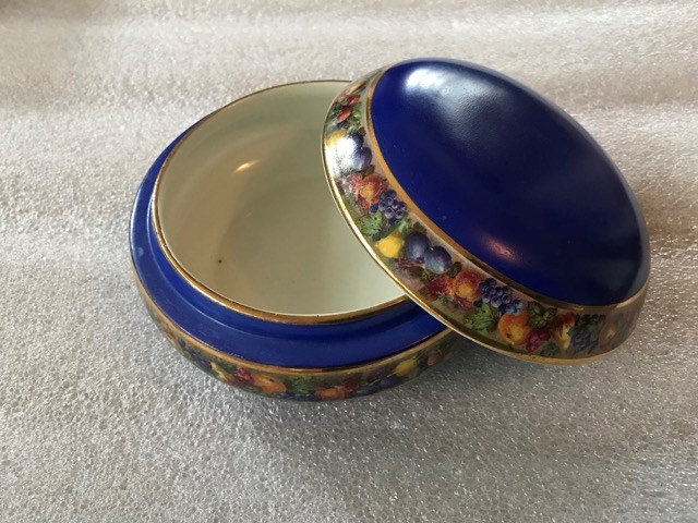
- Date
- 1870 – 1930
- Material
- ceramic
- Catalogue Number
- 102.04.0220
- Description
- Shallow, circular, round, lidded container, white slip with indigo glaze dominant, gold lustre border trim and possibly decal, continuous design around bowl exterior and at lid rim. Decal design is multi-coloured fruit and leaf decoration; "2814" written on base.
1 image
- Title
- Trinket Box
- Date
- 1870 – 1930
- Material
- ceramic
- Dimensions
- 6.2 x 12.7 cm
- Description
- Shallow, circular, round, lidded container, white slip with indigo glaze dominant, gold lustre border trim and possibly decal, continuous design around bowl exterior and at lid rim. Decal design is multi-coloured fruit and leaf decoration; "2814" written on base.
- Credit
- Gift of Catharine Robb Whyte, O. C., Banff, 1979
- Catalogue Number
- 102.04.0220
Images
This material is presented as originally created; it may contain outdated cultural descriptions and
potentially offensive content.
Read more.