Narrow Results By
- Douglas Leighton fonds 10
- Alpine Club of Canada fonds 8
- Ben Gadd fonds 8
- Lillian Gest fonds 8
- Chic Scott fonds 3
- Peter and Catharine Whyte fonds 3
- Trail Riders of the Canadian Rockies fonds 3
- Andy Russell fonds 2
- Bruno Engler fonds 2
- Dorothy Wardle fonds 2
- Maryalice Harvey Stewart fonds 2
- Archives General File Collection 1
Business licenses and applications
https://archives.whyte.org/en/permalink/descriptions56045
- Part Of
- Ben Gadd fonds
- Scope & Content
- File consists of business licenses, application forms and letters of approval sent between Parks Canada and Ben Gadd's guiding company, Ben Gadd Interpretive Services. File includes laminated and paper business license cards used by Ben Gadd between 1997 and 2016.
- Date Range
- 1996-2017
- Reference Code
- M590 / III / B / 37 to 38
- Description Level
- 5 / File
- GMD
- Textual record
- Government record
- Part Of
- Ben Gadd fonds
- Description Level
- 5 / File
- Fonds Number
- M590
- V810
- S61
- Series
- M590 / III : Professional records
- Sous-Fonds
- M590
- Sub-Series
- M590 / III / B : Interpretive guiding
- Accession Number
- 2021.20
- Reference Code
- M590 / III / B / 37 to 38
- Responsibility
- Produced by the Department of Canadian Heritage and Parks Canada
- Date Range
- 1996-2017
- Physical Description
- 4 cm of textual records
- Scope & Content
- File consists of business licenses, application forms and letters of approval sent between Parks Canada and Ben Gadd's guiding company, Ben Gadd Interpretive Services. File includes laminated and paper business license cards used by Ben Gadd between 1997 and 2016.
- Name Access
- Gadd, Ben
- Subject Access
- Parks Canada
- National parks and reserves
- Guides
- Guiding
- Hiking
- Businesses
- Geographic Access
- Canada
- Alberta
- Jasper National Park
- Banff National Park
- British Columbia
- Yoho National Park
- Kootenay National Park
- Reproduction Restrictions
- Restrictions may apply
- Language
- English
- Category
- Government
- Title Source
- Title based on contents of file
- Processing Status
- Processed
This material is presented as originally created; it may contain outdated cultural descriptions and
potentially offensive content.
Read more.
Canadian Rockies
https://archives.whyte.org/en/permalink/descriptions54817
- Part Of
- Murray Hay fonds
- Scope & Content
- File consists of 1 cm of textual records, 10 x 22 cm. File pertains to tourist maps of the Canadian Rocky Mountains created by Murray Hay. File includes a brochure of titled "Canadian Rockies Access Maps" that, when unfolded, includes several maps of the various areas that make up the Canadian Rock…
- Date Range
- ca. 1990 - 1999
- 1999
- Reference Code
- M570 / III / D / i / 2
- Description Level
- 5 / File
- GMD
- Published record
- Map
- Textual record
- Part Of
- Murray Hay fonds
- Description Level
- 5 / File
- Fonds Number
- M570 / V795
- Series
- M570 / III : Murray Hay portfolio (published material)
- Sous-Fonds
- M570
- Sub-Series
- M570 / III / D : Miscellaneous / i : Canada (general)
- Accession Number
- 2019.41
- Reference Code
- M570 / III / D / i / 2
- Date Range
- ca. 1990 - 1999
- 1999
- Physical Description
- 1 cm of textual records (10 x 22 cm)
- Scope & Content
- File consists of 1 cm of textual records, 10 x 22 cm. File pertains to tourist maps of the Canadian Rocky Mountains created by Murray Hay. File includes a brochure of titled "Canadian Rockies Access Maps" that, when unfolded, includes several maps of the various areas that make up the Canadian Rocky Mountains, like Kananaskis Country, Canmore, Banff National Park, Jasper National Park, Yoho National Park, etc.
- Name Access
- Hay, Murray
- Subject Access
- Advertising
- Artist
- Banff
- Banff National Park
- Cartography
- Communications
- Lake Louise
- Kananaskis Country
- Map
- Mountains
- Tourism
- Tourist information
- Travel
- Geographic Access
- Canada
- Canadian Rocky Mountains
- Alberta
- British Columbia
- Yoho National Park
- Jasper National Park
- Banff National Park
- Glacier National Park
- Canmore
- Banff
- Jasper
- Lake Louise
- Kananaskis
- Kananaskis Country
- Kootenay National Park
- Language
- English
- Title Source
- Title based on contents of file
- Processing Status
- Processed
This material is presented as originally created; it may contain outdated cultural descriptions and
potentially offensive content.
Read more.
Construction, Banff-Windermere Higw
https://archives.whyte.org/en/permalink/descriptions57602
- Part Of
- Bruno Engler fonds
- Scope & Content
- Item consists of one 16 mm motion picture pertaining to construction of the Banff-Windermere Highway. Includes mostly footage of large construction machines grading and building the foundations of the highway, as well as drilling underneath the highway, presumably for drainage purposes. The origina…
- Date Range
- 1958
- Reference Code
- V190 / VI / NF - 24
- Description Level
- 6 / Item
- GMD
- Film
- Motion picture
1 image
- Part Of
- Bruno Engler fonds
- Description Level
- 6 / Item
- Fonds Number
- M323 / S40 / V190
- Series
- VI : Retained file
- Sous-Fonds
- V190
- Accession Number
- 7436
- Reference Code
- V190 / VI / NF - 24
- GMD
- Film
- Motion picture
- Date Range
- 1958
- Physical Description
- 1 motion picture (1 film reel: ca. 300'): 16 mm, original, col., silent
- History / Biographical
- See fonds level description
- Scope & Content
- Item consists of one 16 mm motion picture pertaining to construction of the Banff-Windermere Highway. Includes mostly footage of large construction machines grading and building the foundations of the highway, as well as drilling underneath the highway, presumably for drainage purposes. The original label on the case reads "Construction, Banff-Windermere Higw, Color, Date 1958, Footage 300ft, Camera: B. Engler."
- Subject Access
- Automobiles
- Construction
- Mountains
- Scenery
- scenic
- Roads
- Geographic Access
- Banff National Park
- Alberta
- Kootenay National Park
- British Columbia
- Language
- English
- Creator
- Engler, Bruno
- Title Source
- Original title kept
- Processing Status
- Processed
Images

This material is presented as originally created; it may contain outdated cultural descriptions and
potentially offensive content.
Read more.
Elk, Pronghorn, Deer, Bison and Horses
https://archives.whyte.org/en/permalink/descriptions56129
- Part Of
- Douglas Leighton fonds
- Scope & Content
- File consists of photographs of Elk, Pronghorn, Deer, Bison and Horses
- Date Range
- 1984 - 1985
- 1987 - 1990
- 1992 - 1993
- 1995
- 1996
- 1998
- 1999
- Reference Code
- V222 / II / A / 6 / NS - 1 to 131
- Description Level
- 5 / File
- GMD
- Photograph
- Transparency
- Part Of
- Douglas Leighton fonds
- Description Level
- 5 / File
- Fonds Number
- M133
- V222
- Series
- V222 / II : Animals
- Sous-Fonds
- V222
- Sub-Series
- V222 / II / A : Ungulates
- Accession Number
- 2020.24
- Reference Code
- V222 / II / A / 6 / NS - 1 to 131
- Date Range
- 1984 - 1985
- 1987 - 1990
- 1992 - 1993
- 1995
- 1996
- 1998
- 1999
- Physical Description
- 131 photographs : col. slides ; 35 mm
- Scope & Content
- File consists of photographs of Elk, Pronghorn, Deer, Bison and Horses
- Name Access
- Leighton, Douglas
- Subject Access
- Mule Deer
- Whitetail Deer
- Mountain Goat
- Moose
- Pronghorn
- Elk
- Woodland Caribou
- Bighorn Sheep
- Wild Horses
- Geographic Access
- Banff National Park
- Kootenay National Park
- Suffield National Wildlife Area
- Suffield, Alberta
- Language
- English
- Creator
- Douglas Leighton
- Title Source
- Title based on contents of file
- Processing Status
- Processed
This material is presented as originally created; it may contain outdated cultural descriptions and
potentially offensive content.
Read more.
[E.P. Hut and Neil Colgan Land Rents]
https://archives.whyte.org/en/permalink/descriptions58105
- Part Of
- Alpine Club of Canada fonds
- Scope & Content
- File contains the Land Rent documents for the Elizabeth Parker and Neil Colgan huts from 1987 and 1988.
- Date Range
- 1987-1988
- Reference Code
- M200 / II / A / 126
- Description Level
- 5 / File
- GMD
- Textual record
- Organization record
- Part Of
- Alpine Club of Canada fonds
- Description Level
- 5 / File
- Fonds Number
- M200
- V14
- S6
- Series
- M200 / II: Financial Records
- Sous-Fonds
- M200
- Sub-Series
- M200 / II / A: Financial Statements and Reports
- Accession Number
- accn. 2023.06
- Reference Code
- M200 / II / A / 126
- Date Range
- 1987-1988
- Physical Description
- 0.5 cm of textual records
- Scope & Content
- File contains the Land Rent documents for the Elizabeth Parker and Neil Colgan huts from 1987 and 1988.
- Name Access
- Alpine Club of Canada
- Subject Access
- Administration
- Alpine Club of Canada
- Club
- Record keeping
- Records
- Finances
- Organizations
- Geographic Access
- Canada
- Canadian Rocky Mountains
- Rocky Mountains
- Continental Divide
- Great Divide
- Alberta
- British Columbia
- Banff
- Banff, AB
- Yoho National Park
- Kootenay National Park
- Lake O'Hara
- Mount Little
- Mount Bowlen
- Language
- English
- Title Source
- Title based on contents of file
- Processing Status
- Processed
This material is presented as originally created; it may contain outdated cultural descriptions and
potentially offensive content.
Read more.
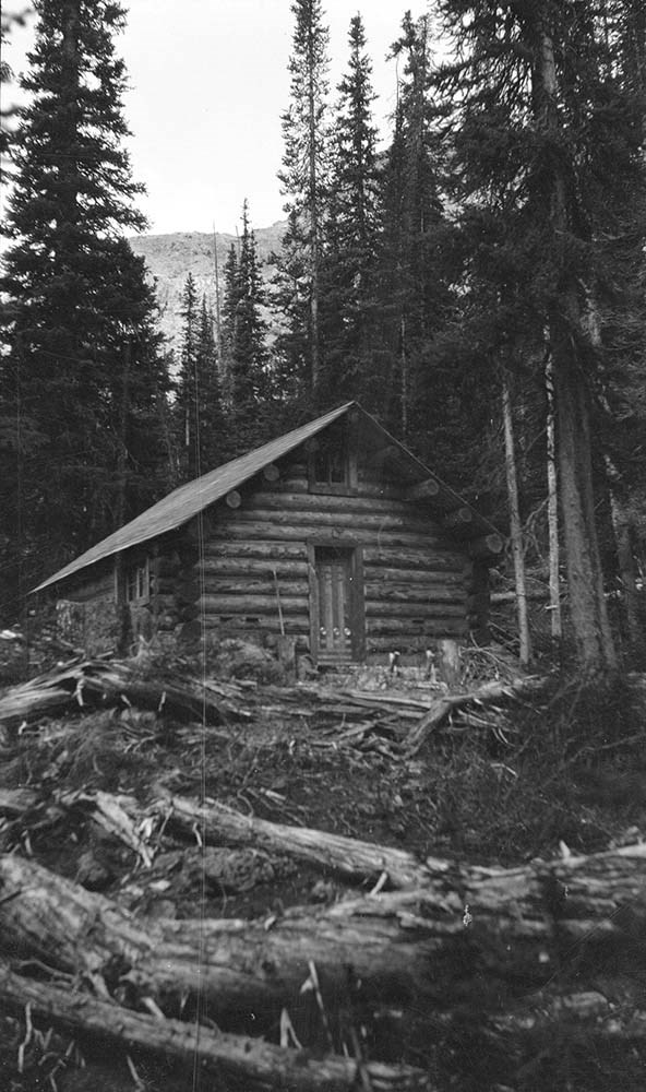
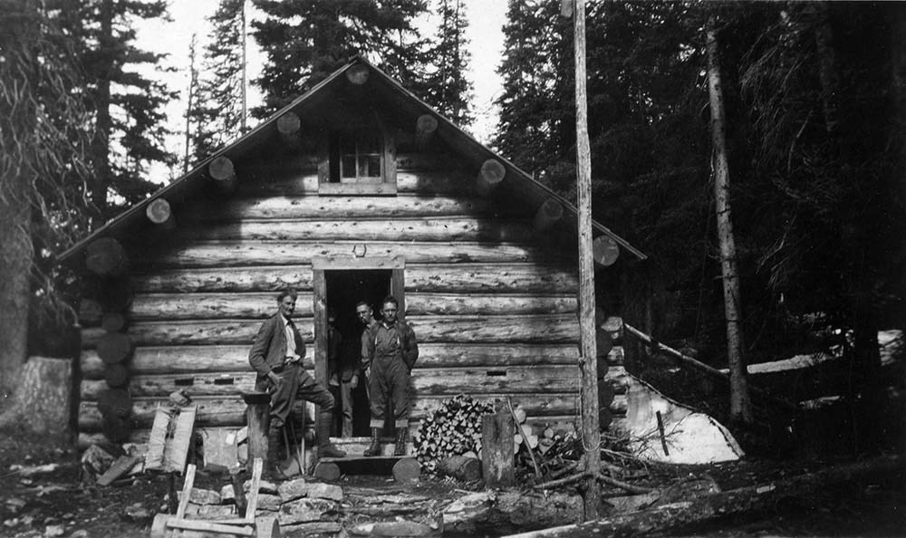
Fay Hut and Floe Lake
https://archives.whyte.org/en/permalink/descriptions3588
- Part Of
- Lawrence Grassi fonds
- Scope & Content
- File pertains to Fay Hut and Floe Lake in Kootenay National Park.
- Date Range
- [ca. 1930-1970]
- Reference Code
- V240 / II / A / PA - 428 to 433
- Description Level
- 5 / File
- GMD
- Photograph
- Photograph print
2 images
- Part Of
- Lawrence Grassi fonds
- Description Level
- 5 / File
- Fonds Number
- M45 / V240
- Series
- II.A. Landscape photographs
- Sous-Fonds
- V240
- Accession Number
- .
- Reference Code
- V240 / II / A / PA - 428 to 433
- Date Range
- [ca. 1930-1970]
- Physical Description
- 6 photographs : prints
- History / Biographical
- See fonds level description
- Scope & Content
- File pertains to Fay Hut and Floe Lake in Kootenay National Park.
- Name Access
- Grassi, Lawrence
- Subject Access
- Buildings
- Cabins
- Cabins and shelters
- Fay Hut
- Geographic Access
- Floe Lake
- Kootenay National Park
- British Columbia
- Canada
- Language
- NA
- Title Source
- Title based on contents of file
- Processing Status
- Processed
Images
This material is presented as originally created; it may contain outdated cultural descriptions and
potentially offensive content.
Read more.
Fay Hut Registers
https://archives.whyte.org/en/permalink/descriptions57645
- Part Of
- Alpine Club of Canada fonds
- Scope & Content
- Sub-series of hut registers from the Fay Hut produced by the Alpine Club of Canada between 1978 and 2007. Registers include entries from visitors to the huts which pertain to individuals' hiking and climbing trips; details of specific events which occurred while staying at the hut, wildlife sightin…
- Date Range
- 1978-2000 2005-2007
- Reference Code
- M200 / IV / H
- Description Level
- 4 / Sub-series
- GMD
- Textual record
- Organization record
- Part Of
- Alpine Club of Canada fonds
- Description Level
- 4 / Sub-series
- Fonds Number
- M200
- V14
- S6
- Series
- M200 / IV: Hut Registers
- Sous-Fonds
- M200
- Sub-Series
- M200 / IV / H: Fay Hut Registers
- Accession Number
- accn. 8120
- accn. 6465
- accn. 2023.10
- accn. 8002
- Reference Code
- M200 / IV / H
- Responsibility
- Registers produced by Alpine Club of Canada
- Date Range
- 1978-2000 2005-2007
- Physical Description
- 13 cm of textual records 7 volumes
- History / Biographical
- The Fay Hut was built in 1927, and it was the first structure built by the Alpine Club of Canada. The original Fay Hut building was burnt down in a forest fire in 2003, but was rebuilt in 2005 by ACC volunteers. The re-built Fay Hut burnt down in 2009. The Fay Hut was located in Kootenay National Park, British Columbia, in Prospector's Valley. The hut was also used as a stopping point for mountaineers on their way to the Neil Colgan Hut or the Valley of Ten Peaks. The Fay Hut was named after Charles Fay, a founder and President of the American Alpine Club. Charles Fay made over 20 trips to the Canadian Rockies. He also participated in the first ascents of Mount Victoria and Mount Lefroy. Fay was also an Honorary Member of the Alpine Club of Canada.
- Scope & Content
- Sub-series of hut registers from the Fay Hut produced by the Alpine Club of Canada between 1978 and 2007. Registers include entries from visitors to the huts which pertain to individuals' hiking and climbing trips; details of specific events which occurred while staying at the hut, wildlife sightings, custodial issues and updates, and related topics. The sub-series is separated into individual hut registers, arranged by date:
- M200 / IV / H / 1: Fay Hut Register [1978-1983]
- M200 / IV / H / 2: Fay Hut Registers [1980-1985]
- M200 / IV / H / 3: Fay Hut [1983-1991]
- M200 / IV / H / 4: "Fay Hut 1991" July 15, 1991 - Aug. 22, 1995
- M200 / IV / H / 5: Fay Hut register. Aug. 24, 1995 - Nov. 24, 1997
- M200 / IV / H / 6: Fay Hut Register [1997-2000]
- M200 / IV / H / 7: Fay Hut, 2005 - 2007 Hut Register
- Name Access
- Alpine Club of Canada
- Subject Access
- Alpine Club of Canada
- Backcountry skiing
- British Columbia
- Buildings and facilities
- Cabins and shelters
- Climbing
- Environment and Nature
- Fay Hut
- Fire
- Forest Fires
- Huts
- Mountaineering
- Mountaineers
- Mountains
- Geographic Access
- Canada
- British Columbia
- Kootenay National Park
- Access Restrictions
- Restrictions may apply
- Language
- English
- German
- French
- Biographical Source Notes
- Canadian Rockies Database: https://cdnrockiesdatabases.ca/people/19
- Title Source
- Title based on contents of sub-series
- Processing Status
- Processed
This material is presented as originally created; it may contain outdated cultural descriptions and
potentially offensive content.
Read more.
Four Mountain Parks Planning Program
https://archives.whyte.org/en/permalink/descriptions54919
- Scope & Content
- File consists of a planning scenario draft, response form and information sheet, draft of possible implications, meeting notes and comments, and correspondence between Parks Canada and the Trail Riders of the Canadian Rockies. Content pertains to the Four Mountain Parks Program implemented by Parks…
- Date Range
- 1984-1985
- Reference Code
- M545 / V / 24
- Description Level
- 5 / File
- GMD
- Textual record
- Government record
- Description Level
- 5 / File
- Fonds Number
- M545 / V635
- Series
- M545 / V : Administrative records
- Sous-Fonds
- M545
- Accession Number
- 5939
- Reference Code
- M545 / V / 24
- Date Range
- 1984-1985
- Physical Description
- 2 cm of textual records
- Scope & Content
- File consists of a planning scenario draft, response form and information sheet, draft of possible implications, meeting notes and comments, and correspondence between Parks Canada and the Trail Riders of the Canadian Rockies. Content pertains to the Four Mountain Parks Program implemented by Parks Canada between 1984 and 1985, and related changes adapted by the Trail Riders. Topics include wildlife and resource management, trail use and maintenance, townsite development, hunting and fishing, and other related subjects within Banff, Jasper, Yoho and Kootenay National Parks.
- Notes
- Planning scenario draft has annotations on front cover, annotations and illustrations on second interior page
- Subject Access
- Government
- Environment
- Natural resources
- Townsite development
- Wildlife
- Wildfire
- Conservation
- Ecology
- Fishing
- Forestry
- Hunting
- Land use
- Laws and legislation
- National parks and reserves
- Parks Canada
- Park policy
- Geographic Access
- Canada
- Alberta
- British Columbia
- Banff National Park
- Jasper National Park
- Kootenay National Park
- Yoho National Park
- Language
- English
- Conservation
- Plastic binding removed from planning scenario draft
- Category
- Environment
- Government
- Land, settlement and immigration
- Natural resources
- Sports, recreation and leisure
- Title Source
- Title copied from contents in file
- Processing Status
- Processed
This material is presented as originally created; it may contain outdated cultural descriptions and
potentially offensive content.
Read more.
Four Mountains bicycle report
https://archives.whyte.org/en/permalink/descriptions56075
- Part Of
- Ben Gadd fonds
- Scope & Content
- File consists of correspondence, notes, finished drafts and other materials pertaining to a paper which Ben Gadd wrote for Parks Canada about bicycle use in the Four Mountain Parks (Banff, Jasper, Yoho and Kootenay). Ben's paper was used as background information/reference material during the creat…
- Date Range
- 1982
- Reference Code
- M590 / III / A / 12
- Description Level
- 5 / File
- GMD
- Textual record
- Newspaper clipping
- Part Of
- Ben Gadd fonds
- Description Level
- 5 / File
- Fonds Number
- M590
- V810
- S61
- Series
- M590 / III : Professional records
- Sous-Fonds
- M590
- Sub-Series
- M590 / III / A : Parks Canada records
- Accession Number
- 2021.20
- Reference Code
- M590 / III / A / 12
- Date Range
- 1982
- Physical Description
- 1 cm of textual records
- Scope & Content
- File consists of correspondence, notes, finished drafts and other materials pertaining to a paper which Ben Gadd wrote for Parks Canada about bicycle use in the Four Mountain Parks (Banff, Jasper, Yoho and Kootenay). Ben's paper was used as background information/reference material during the creation of the Four Mountain Parks Planning Program by Parks Canada.
- Name Access
- Gadd, Ben
- Subject Access
- Parks Canada
- Government
- Environment
- Sports
- Recreation
- Bicycles
- National parks and reserves
- Geographic Access
- Canada
- Alberta
- British Columbia
- Jasper National Park
- Kootenay National Park
- Yoho National Park
- Banff National Park
- Reproduction Restrictions
- Restrictions may apply
- Language
- English
- Category
- Environment
- Government
- Title Source
- Title based on contents of file
- Processing Status
- Processed
This material is presented as originally created; it may contain outdated cultural descriptions and
potentially offensive content.
Read more.
Four Mountains Parks Planning Program notes
https://archives.whyte.org/en/permalink/descriptions56076
- Part Of
- Ben Gadd fonds
- Scope & Content
- File consists of handwritten notes by Ben Gadd describing his thuoghts and concerns pertaining to the Four Mountains Parks Planning Program led by Parks Canada.
- Date Range
- [1982-1983]
- Reference Code
- M590 / III / A / 13
- Description Level
- 5 / File
- GMD
- Textual record
- Newspaper clipping
- Part Of
- Ben Gadd fonds
- Description Level
- 5 / File
- Fonds Number
- M590
- V810
- S61
- Series
- M590 / III : Professional records
- Sous-Fonds
- M590
- Sub-Series
- M590 / III / A : Parks Canada records
- Accession Number
- 2021.20
- Reference Code
- M590 / III / A / 13
- Date Range
- [1982-1983]
- Physical Description
- 0.1 cm of textual records
- Scope & Content
- File consists of handwritten notes by Ben Gadd describing his thuoghts and concerns pertaining to the Four Mountains Parks Planning Program led by Parks Canada.
- Name Access
- Gadd, Ben
- Subject Access
- Parks Canada
- Government
- Environment
- National parks and reserves
- Conservation
- Tourism
- Geographic Access
- Canada
- Alberta
- British Columbia
- Jasper National Park
- Kootenay National Park
- Yoho National Park
- Banff National Park
- Reproduction Restrictions
- Restrictions may apply
- Language
- English
- Category
- Environment
- Government
- Title Source
- Title based on contents of file
- Processing Status
- Processed
This material is presented as originally created; it may contain outdated cultural descriptions and
potentially offensive content.
Read more.
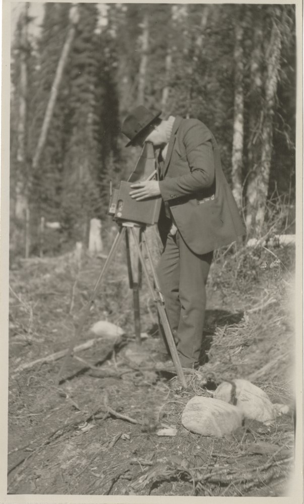
George Noble with camera
https://archives.whyte.org/en/permalink/descriptions53247
- Part Of
- Peter and Catharine Whyte fonds
- Scope & Content
- Image of George Noble taking a photograph with a camera mounted on a tripod with trees in the background - "George Nobel" is written in blue ink on the back above "at Marble Canyon about 1920" in pencil
- Date Range
- [ca. 1920]
- Reference Code
- V683 / III / A / 15 / PA - 814
- Description Level
- 6 / Item
- GMD
- Photograph
2 images
- Part Of
- Peter and Catharine Whyte fonds
- Description Level
- 6 / Item
- Fonds Number
- M36 / V683 / S37
- Series
- V683 / III / A / 15 : Peter and Catharine Whyte: Collected Photographs
- Sous-Fonds
- V683
- Accession Number
- .
- Reference Code
- V683 / III / A / 15 / PA - 814
- GMD
- Photograph
- Date Range
- [ca. 1920]
- Physical Description
- Photograph: 1 print (front and back) ; b&w.
- Scope & Content
- Image of George Noble taking a photograph with a camera mounted on a tripod with trees in the background - "George Nobel" is written in blue ink on the back above "at Marble Canyon about 1920" in pencil
- Name Access
- Nobel, George
- Subject Access
- Cameras
- Photography
- Geographic Access
- Marble Canyon
- Kootenay National Park
- Language
- English
- Title Source
- Title based on item
- Processing Status
- Processed
Images

This material is presented as originally created; it may contain outdated cultural descriptions and
potentially offensive content.
Read more.
- Part Of
- Crosby family fonds
- Scope & Content
- File consists of correspondence and maps relating to various hikes in the Rocky Mountains and area. Including Assiniboine Selkirk Mountains, Athabasca Glacier
- Date Range
- 1937
- 1938
- Reference Code
- M486 / V / C / 7
- Description Level
- 5 / File
- GMD
- Textual record
- Part Of
- Crosby family fonds
- Description Level
- 5 / File
- Fonds Number
- M486 / V152
- Series
- M486 / V : Crosby Family Papers
- Sous-Fonds
- M486
- Sub-Series
- M486 / V / C : Douglas Crosby
- Reference Code
- M486 / V / C / 7
- GMD
- Textual record
- Date Range
- 1937
- 1938
- Physical Description
- 2 cm of textual records
- Scope & Content
- File consists of correspondence and maps relating to various hikes in the Rocky Mountains and area. Including Assiniboine Selkirk Mountains, Athabasca Glacier
- Name Access
- Crosby, Douglas
- Crosby, Doug
- Subject Access
- Correspondence
- Geographic Access
- Banff, Alberta
- Kootenay National Park
- Language
- English
- Title Source
- Title based on contents of fonds
- Processing Status
- Processed
This material is presented as originally created; it may contain outdated cultural descriptions and
potentially offensive content.
Read more.
Marjorie Youhill Photograph Album
https://archives.whyte.org/en/permalink/descriptions54491
- Part Of
- Archives General File Collection
- Scope & Content
- Item consists of one bound album of 158 black and white photographs and one train ticket, H18.5 x W28.5 cm. Photographs pertain to travels in Banff, Canmore, Lake Louise, Yoho National Park, Kootenay National Park, and Vancouver Island. Other points of interest that are depicted in the photographs …
- Date Range
- [c.1948]
- Reference Code
- V8 / 2014.8260 / PD - 1
- Description Level
- 6 / Item
- GMD
- Album
- Private record
- Part Of
- Archives General File Collection
- Description Level
- 6 / Item
- Fonds Number
- M8 / V8 / S8
- Series
- 2014.8260 : Accession Number
- Sous-Fonds
- V8
- Accession Number
- 2014.8260
- Reference Code
- V8 / 2014.8260 / PD - 1
- GMD
- Album
- Private record
- Date Range
- [c.1948]
- Physical Description
- 1 album (159 photographs : b&w ; 28.5 x 18.5 cm)
- History / Biographical
- Marjorie Youhill, born c.1910s, was born, raised, and worked in Winnipeg, Manitoba, Canada. She was a Christian Scientist, had one stepsister, and never married. Marjorie retired in Victoria, British Columbia, Canada, where she died at the Glengarry Hospital. She left her financial estate to Loreen Dunklee, her cousin.
- Scope & Content
- Item consists of one bound album of 158 black and white photographs and one train ticket, H18.5 x W28.5 cm. Photographs pertain to travels in Banff, Canmore, Lake Louise, Yoho National Park, Kootenay National Park, and Vancouver Island. Other points of interest that are depicted in the photographs include: Banff Springs golf course, Bow Falls, Cave and Basin, Sulphur Mountain Chalet, Takakkaw Falls, and Lakes O'Hara and McArthur.
- Notes
- Album also contains a train ticket for the Canadian Pacific Railway traveling from Winnipeg to Banff, dated August 7, 1948.
- Name Access
- Youhill, Marjorie
- Subject Access
- Travel
- Golfing
- Fairmont Banff Springs Hotel
- Sulphur Mountain Chalet
- Sulphur Mountain lookout
- Hiking
- Lake O'Hara region
- Cave and Basin
- Canadian Pacific Railway
- Family and personal life
- Women
- Geographic Access
- Alberta
- Banff
- Banff National Park
- British Columbia
- Canada
- Canadian Rocky Mountains
- Canmore
- Cave and Basin
- Kootenay National Park
- Lake Louise
- Lake O'Hara
- Sulphur Mountain
- Yoho National Park
- Language
- English
- Biographical Source Notes
- Information provided on the gift agreement
- Title Source
- Title based on contents of file
- Processing Status
- Processed
This material is presented as originally created; it may contain outdated cultural descriptions and
potentially offensive content.
Read more.
Mount Deltaform Summit Note
https://archives.whyte.org/en/permalink/descriptions57779
- Part Of
- Alpine Club of Canada fonds
- Scope & Content
- File consists of a summit record from Mount Deltaform produced by the Alpine Club of Canada in 1983. Summit note by Hans Fuhrer and David Wilkinson depicting their route to the summit.
- Date Range
- 1983
- Reference Code
- M200 / V / A / 193
- Description Level
- 5 / File
- GMD
- Textual record
- Organization record
- Part Of
- Alpine Club of Canada fonds
- Description Level
- 5 / File
- Fonds Number
- M200
- V14
- S6
- Series
- M200 / V: Summit Records
- Sous-Fonds
- M200
- Sub-Series
- M200 / V / A: Identified Summit Records
- Accession Number
- accn. 8119
- Reference Code
- M200 / V / A / 193
- Responsibility
- Summit Registers and Notes produced by Alpine Club of Canada
- Date Range
- 1983
- Physical Description
- 0.5 cm of textual record 1 summit note
- History / Biographical
- Mount Deltaform is located in the Valley of the Ten Peaks, along the Continental Divide/Great Divide of the Canadian Rockies. Mount Deltaform is also on the border of Kootenay National Park, BC and Banff National Park, AB. Nearby are Hungabee Mountain, Mount Tuzo, and Mount Whymper.
- Scope & Content
- File consists of a summit record from Mount Deltaform produced by the Alpine Club of Canada in 1983. Summit note by Hans Fuhrer and David Wilkinson depicting their route to the summit.
- Name Access
- Alpine Club of Canada
- Subject Access
- Alberta
- Banff National Park
- British Columbia
- Climbing
- Description and travel
- Environment
- Environment and Nature
- Great Divide
- Hiking
- Mountain
- Mountaineering
- Mountaineers
- Mountains
- National parks and reserves
- Record keeping
- Sports and leisure
- Sports and recreation
- Summit
- Geographic Access
- Canada
- Canadian Rocky Mountains
- Rocky Mountains
- Continental Divide
- Great Divide
- Alberta
- British Columbia
- Banff National Park
- Kootenay National Park
- Valley of the Ten Peaks
- Hungabee Mountain
- Mount Whymper
- Mount Tuzo
- Mount Deltaform
- Access Restrictions
- Restrictions may apply
- Language
- English
- Related Material
- M235
- Biographical Source Notes
- Peak Finder: Deltaform Mountain, Canadian Rockies Database: https://cdnrockiesdatabases.ca/peaks/365
- Title Source
- Original title
- Processing Status
- Processed
This material is presented as originally created; it may contain outdated cultural descriptions and
potentially offensive content.
Read more.
Mt. Little Summit Register
https://archives.whyte.org/en/permalink/descriptions57757
- Part Of
- Alpine Club of Canada fonds
- Scope & Content
- File consists of summit notes from Mount Little produced by the Alpine Club of Canada between 2001 and 2017. Summit notes include entries from visitors to the various summits which pertain to individuals' hiking and climbing trips; details of specific events which occurred while at the summit, wild…
- Date Range
- 2001-2017
- Reference Code
- M200 / V / A / 170
- Description Level
- 5 / File
- GMD
- Textual record
- Organization record
- Part Of
- Alpine Club of Canada fonds
- Description Level
- 5 / File
- Fonds Number
- M200
- V14
- S6
- Series
- M200 / V: Summit Records
- Sous-Fonds
- M200
- Sub-Series
- M200 / V / A: Identified Summit Records
- Accession Number
- accn. 2018.9010
- Reference Code
- M200 / V / A / 170
- Responsibility
- Summit Registers and Notes produced by Alpine Club of Canada
- Date Range
- 2001-2017
- Physical Description
- 1 volume 1 cm of textual records
- History / Biographical
- Mount Little is located on the Continental/Great Divide, and is part of the Canadian Rockies on the border of Alberta and British Columbia.
- Scope & Content
- File consists of summit notes from Mount Little produced by the Alpine Club of Canada between 2001 and 2017. Summit notes include entries from visitors to the various summits which pertain to individuals' hiking and climbing trips; details of specific events which occurred while at the summit, wildlife sightings, trail updates, and related topics. File: M200 / V / A / 170: Mt. Little Summit Register
- Name Access
- Alpine Club of Canada
- Subject Access
- Alberta
- Alpine Club of Canada
- Backpacking
- Banff National Park
- British Columbia
- Climbing
- Club
- Description and travel
- Environment
- Environment and Nature
- Great Divide
- Hiking
- Mountain
- Mountaineering
- Mountaineers
- Mountains
- National parks and reserves
- Record keeping
- Sports and leisure
- Sports and recreation
- Summit
- Trails
- Geographic Access
- Canada
- Great Divide
- Continental Divide
- Canadian Rocky Mountains
- Rocky Mountains
- British Columbia
- Alberta
- Kootenay National Park
- Banff National Park
- Lake Louise
- Valley of the Ten Peaks
- Mount Victoria
- Mount Temple
- Mount Babel
- Mount Bell
- Deltaform Mountain
- Mount Little
- Access Restrictions
- Restrictions may apply
- Language
- English
- Conservation
- Summit notes are written on sticky notes; some pages have stuck together. Glue from sticky notes has bled onto the pages.
- Related Material
- M235
- Biographical Source Notes
- Peak Finder: Mount Little, Canadian Rockies Database: https://cdnrockiesdatabases.ca/peaks/788
- Title Source
- Original title
- Processing Status
- Processed
This material is presented as originally created; it may contain outdated cultural descriptions and
potentially offensive content.
Read more.
Mt. Whymper Summit Registry
https://archives.whyte.org/en/permalink/descriptions57778
- Part Of
- Alpine Club of Canada fonds
- Scope & Content
- File consists of a summit record from Mount Whymper produced by the Alpine Club of Canada between 1987 and 2007. Summit record includes entries from visitors to the various summits which pertain to individuals' hiking and climbing trips; details of specific events which occurred while at the summit…
- Date Range
- 1987-2007
- Reference Code
- M200 / V / A / 192
- Description Level
- 5 / File
- GMD
- Textual record
- Organization record
- Part Of
- Alpine Club of Canada fonds
- Description Level
- 5 / File
- Fonds Number
- M200
- V14
- S6
- Series
- M200 / V: Summit Records
- Sous-Fonds
- M200
- Sub-Series
- M200 / V / A: Identified Summit Records
- Accession Number
- accn. 8119
- Reference Code
- M200 / V / A / 192
- Responsibility
- Summit Registers and Notes produced by Alpine Club of Canada
- Date Range
- 1987-2007
- Physical Description
- 1 volume 1 cm of textual record
- History / Biographical
- Mount Whymper is located in Kootenay National Park, British Columbia, near the Continental Divide/Great Divide, in the Canadian Rockies. Nearby are Storm Mountain, Vermillion Peak, Highway 93 and Chimper Peak.
- Scope & Content
- File consists of a summit record from Mount Whymper produced by the Alpine Club of Canada between 1987 and 2007. Summit record includes entries from visitors to the various summits which pertain to individuals' hiking and climbing trips; details of specific events which occurred while at the summit, wildlife sightings, trail updates, and related topics. File: M200 / V / A / 192: Mt. Whymper Summit Registry
- Name Access
- Alpine Club of Canada
- Subject Access
- Alpine Club of Canada
- Backpacking
- British Columbia
- Climbing
- Club
- Description and travel
- Environment
- Environment and Nature
- Great Divide
- Hiking
- Mountain
- Mountaineering
- Mountaineers
- Mountains
- National parks and reserves
- Record keeping
- Sports and leisure
- Sports and recreation
- Summit
- Trails
- Geographic Access
- Canada
- Canadian Rocky Mountains
- Rocky Mountains
- Continental Divide
- Great Divide
- British Columbia
- Kootenay National Park
- Vermilion River Valley
- Storm Mountain
- Vermillion Peak
- Mount Whymper
- Access Restrictions
- Restrictions may apply
- Language
- English
- French
- Conservation
- Register contains some rust damage, particularly along the spine of the register. Potential mold.
- Related Material
- M235
- Biographical Source Notes
- Peakery: Mount Whymper map, Peakery: https://peakery.com/mount-whymper-british-columbia/map/
- Title Source
- Original title
- Processing Status
- Processed
This material is presented as originally created; it may contain outdated cultural descriptions and
potentially offensive content.
Read more.
National Geographic projects
https://archives.whyte.org/en/permalink/descriptions55880
- Part Of
- Ben Gadd fonds
- Scope & Content
- File consists of contract agreements, employment documents and related correspondence pertaining to writing projects which Ben Gadd completed for National Geographic. Projects include an article titled "Best of the Rockies: Hiking" [2003]; and summaries of several national parks and other regions o…
- Date Range
- 2003
- 2010
- Reference Code
- M590 / III / D / 1
- Description Level
- 5 / File
- GMD
- Textual record
- Part Of
- Ben Gadd fonds
- Description Level
- 5 / File
- Fonds Number
- M590
- V810
- S61
- Series
- M590 / III : Professional records
- Sous-Fonds
- M590
- Sub-Series
- M590 / III / D : Other contracts and projects
- Accession Number
- 2021.20
- Reference Code
- M590 / III / D / 1
- GMD
- Textual record
- Date Range
- 2003
- 2010
- Physical Description
- 0.2 cm of textual records
- Scope & Content
- File consists of contract agreements, employment documents and related correspondence pertaining to writing projects which Ben Gadd completed for National Geographic. Projects include an article titled "Best of the Rockies: Hiking" [2003]; and summaries of several national parks and other regions of the Canadian Rockies for use in the publication "National Geographic's Guide to the National Parks of Canada" [2010].
- Name Access
- Gadd, Ben
- Subject Access
- National parks and reserves
- Publication
- Research
- Travel
- Geography
- Tourism
- Hiking
- Recreation
- Geographic Access
- Canada
- Alberta
- British Columbia
- Waterton National Park
- Kootenay National Park
- Glacier National Park
- Revelstoke
- Jasper
- Yoho National Park
- Reproduction Restrictions
- Restrictions may apply
- Language
- English
- Title Source
- Title based on contents of file
- Processing Status
- Processed
This material is presented as originally created; it may contain outdated cultural descriptions and
potentially offensive content.
Read more.
National Parks - Kootenay, Yoho, Glacier, Jasper, Waterton Lakes
https://archives.whyte.org/en/permalink/descriptions55243
- Part Of
- Malcolm Geddes fonds
- Scope & Content
- File consists of 70 lantern slide images pertaining to views from Kootenay, Yoho, Glacier, Jasper and Waterton Lakes National Parks. Specific locations include: Marble Canyon and Sinclair Canyon; Mount Stephen, Lake Oesa, Lake O'Hara, Lake McArthur, Takakkaw Falls, Twin Falls and Yoho Glacier; Ille…
- Date Range
- [ca.1925]
- Reference Code
- V756 / III / A / PS - 161 to 230
- Description Level
- 5 / File
- GMD
- Photograph
- Lantern slide
- Part Of
- Malcolm Geddes fonds
- Description Level
- 5 / File
- Fonds Number
- M39
- V756
- Series
- V756 / III : Personal and family records
- Sous-Fonds
- V756
- Sub-Series
- V756 / III / A : Travel and mountain expeditions
- Accession Number
- 6504
- Reference Code
- V756 / III / A / PS - 161 to 230
- Responsibility
- Some items issued by Department of the Interior Natural Resources Intelligence Branch and by Canadian National Railways
- Date Range
- [ca.1925]
- Physical Description
- 70 photographs : lantern slides
- Scope & Content
- File consists of 70 lantern slide images pertaining to views from Kootenay, Yoho, Glacier, Jasper and Waterton Lakes National Parks. Specific locations include: Marble Canyon and Sinclair Canyon; Mount Stephen, Lake Oesa, Lake O'Hara, Lake McArthur, Takakkaw Falls, Twin Falls and Yoho Glacier; Illecillewaet Glacier and surrounding area; Jasper town and Jasper Park Lodge; Maligne Lake, Maligne Canyon, Mount Edith Cavell and Mount Robson; and Waterton Lake area. Most items are captioned.
- Notes
- Slides are organized by location: V756 / III / A / PS - 161 to 167 : Kootenay V756 / III / A / PS - 168 to 185 : Yoho V756 / III / A / PS - 186 to 194 : Glacier V756 / III / A / PS - 195 to 226 : Jasper V756 / III / A / PS - 227 to 230 : Waterton Lakes
- Subject Access
- Travel
- Exploration
- Mountains
- Landscapes
- Glaciers
- Hotels
- Waterfalls
- National parks and reserves
- Tourism
- Recreation
- Geographic Access
- Canada
- Alberta
- British Columbia
- Canadian Rocky Mountains
- Kootenay National Park
- Yoho National Park
- Glacier National Park
- Jasper National Park
- Jasper
- Waterton Lakes National Park
- Waterton
- Access Restrictions
- Fragile - restrictions may apply
- Language
- English
- Title Source
- Title based on contents of file
- Processing Status
- Processed
This material is presented as originally created; it may contain outdated cultural descriptions and
potentially offensive content.
Read more.
- Part Of
- Alpine Club of Canada fonds
- Scope & Content
- File contains multiple quotes for the construction of huts, including costs of building materials and supplies.
- Date Range
- 1982
- Reference Code
- M200 / II / D / 73
- Description Level
- 5 / File
- GMD
- Textual record
- Organization record
- Part Of
- Alpine Club of Canada fonds
- Description Level
- 5 / File
- Fonds Number
- M200
- V14
- S6
- Series
- M200 / II: Financial Records
- Sous-Fonds
- M200
- Sub-Series
- M200 / II / D: Other Financial Records
- Accession Number
- accn. 5634
- Reference Code
- M200 / II / D / 73
- Date Range
- 1982
- Physical Description
- 0.5 cm of textual records
- Scope & Content
- File contains multiple quotes for the construction of huts, including costs of building materials and supplies.
- Name Access
- Alpine Club of Canada
- Subject Access
- Administration
- Alpine Club of Canada
- Buildings
- Club
- Construction
- Finances
- Huts
- Mountain
- Mountaineering
- Mountaineers
- Mountains
- Organizations
- Record keeping
- Records
- Geographic Access
- Canada
- Alberta
- British Columbia
- Calgary, Alberta
- Kootenay National Park
- Fay Glacier
- Language
- English
- Title Source
- Original title
- Processing Status
- Processed
This material is presented as originally created; it may contain outdated cultural descriptions and
potentially offensive content.
Read more.
Newsclippings Scrapbook
https://archives.whyte.org/en/permalink/descriptions5727
- Part Of
- Andy Russell fonds
- Scope & Content
- Scrapbook pertains to Andy Russell.
- Date Range
- 1947-1955
- Reference Code
- M153 / 576
- Description Level
- 5 / File
- GMD
- Scrapbook
1 image
1 Electronic Resource
- Part Of
- Andy Russell fonds
- Description Level
- 5 / File
- Fonds Number
- M153 / S43 / V555
- Sous-Fonds
- M153
- Sub-Series
- VII Russell family series
- Accession Number
- 5777
- Reference Code
- M153 / 576
- GMD
- Scrapbook
- Date Range
- 1947-1955
- Physical Description
- 2 cm of textual records (26 pages ; 30.5 x 35.5 cm)
- History / Biographical
- See fonds level description
- Scope & Content
- Scrapbook pertains to Andy Russell.
- Name Access
- Russell, Andy
- Subject Access
- Academics
- Administration
- Backpacking
- Biographical
- Climatology
- Conservation
- Ecology
- Education
- Environment and Nature
- Films and film making
- Forestry
- Horseback riding
- Personal and Professional Life
- Photography
- Natural history
- Natural resources
- Wildlife
- Wildlife fatalities
- Geographic Access
- Banff
- Lake Louise
- Jasper
- Banff National Park
- Jasper National Park
- Kananaskis
- Yoho National Park
- Kootenay National Park
- Alberta
- British Columbia
- Canada
- Language
- English
- Conservation
- Blank pages not scanned
- Finding Aid
- Access by advance appointment only
- Creator
- Russell, Kay
- Title Source
- Title based on contents of file
- Processing Status
- Processed
Electronic Resources
Images

This material is presented as originally created; it may contain outdated cultural descriptions and
potentially offensive content.
Read more.