Narrow Results By
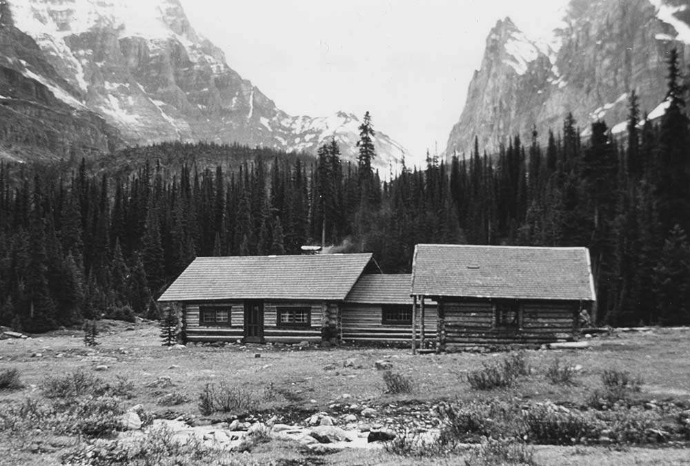
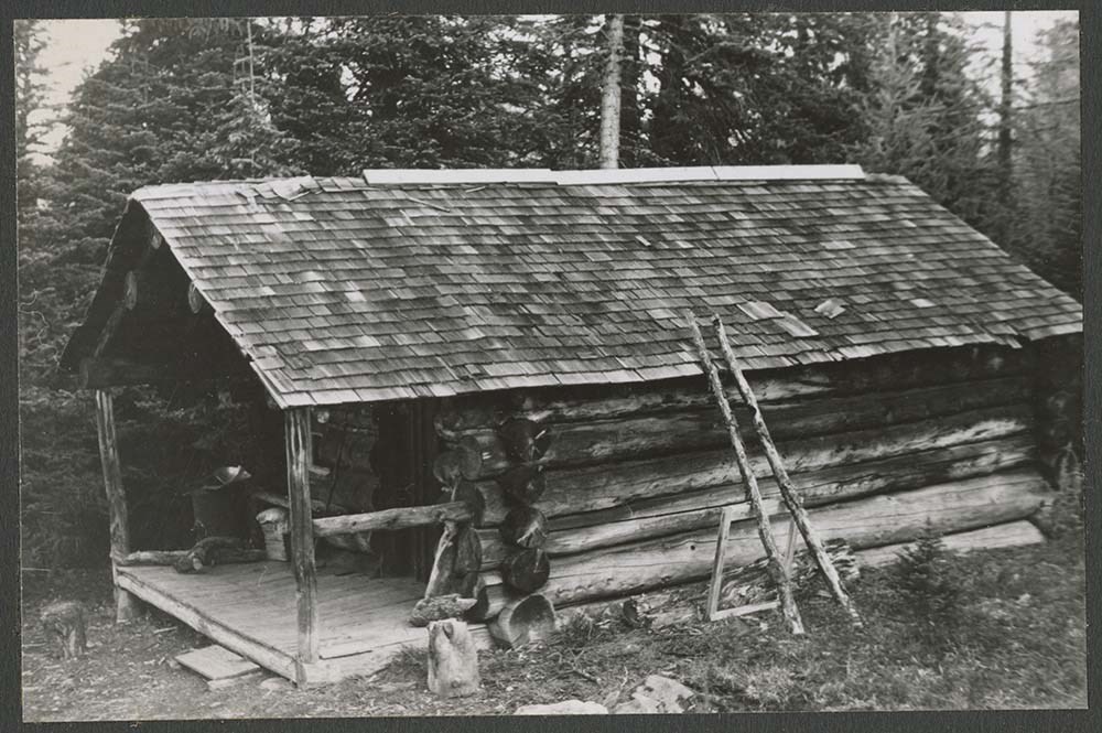
Existing huts, hut photos
https://archives.whyte.org/en/permalink/descriptions6577
- Part Of
- Alpine Club of Canada fonds
- Scope & Content
- File includes letters and photographs, slides, and negatives of huts.
- Date Range
- 1964-1979
- Reference Code
- M200 / AC 421 / 161
- V14 / AC 421P / 106 - 161
- Description Level
- 5 / File
- GMD
- Photograph
- Photograph print
1 image
- Part Of
- Alpine Club of Canada fonds
- Description Level
- 5 / File
- Fonds Number
- M200 / S6 / V14
- Series
- I.A.2.e. Administration: huts / properties
- Sous-Fonds
- V14
- Accession Number
- 5200
- Reference Code
- M200 / AC 421 / 161
- V14 / AC 421P / 106 - 161
- Date Range
- 1964-1979
- Physical Description
- 1 file of textual records. -- 55 photographs (47 prints, 6 negatives, 2 transparencies).
- Scope & Content
- File includes letters and photographs, slides, and negatives of huts.
- Name Access
- Alpine Club of Canada
- Subject Access
- Abbot Pass Hut
- Activities
- Administration
- Advertising
- Alpine Club of Canada
- Alpine Club House
- Cabins
- Cabins and shelters
- Camps
- Club
- Competition
- Discovery and exploration
- Environment
- Environment and Nature
- Exploration
- Guide
- Guides
- Hiking
- Huts
- Mountain
- Mountain guides
- Mountaineering
- Mountaineers
- Mountains
- National parks and reserves
- Organizations
- Photography
- Scenery
- Sports and recreation
- Summit
- Geographic Access
- Banff National Park
- Jasper National Park
- Yoho National Park
- Alberta
- British Columbia
- Canada
- Access Restrictions
- Access to negatives is by appointment only
- Language
- English
- Title Source
- Title based on contents of file
- Processing Status
- Processed
Images
This material is presented as originally created; it may contain outdated cultural descriptions and
potentially offensive content.
Read more.
Club photographs
https://archives.whyte.org/en/permalink/descriptions7214
- Part Of
- Alpine Club of Canada fonds
- Scope & Content
- Includes photographs of ACC property at Mount Assiniboine (accompanied by 2 maps - AC 018P); clubhouse view; move of library to Vancouver Public Library; Board meeting; closing party at the old clubhouse (AC 421P / 09-37); office staff.
- Date Range
- 1953-1983
- Reference Code
- V14 / AC 018P / 1-7
- V14 / AC 041P / 1
- V14 / AC 345P / 1-3
- V14 / AC 363P / 1
- V14 / AC 421P / 09-37
- V14 / AC 421P / 52-53
- Description Level
- 5 / File
- GMD
- Photograph
- Photograph print
5 images
- Part Of
- Alpine Club of Canada fonds
- Description Level
- 5 / File
- Fonds Number
- M200 / S6 / V14
- Series
- I.A.2.i. Administration: photography and photographs
- Sous-Fonds
- V14
- Accession Number
- 5200
- Reference Code
- V14 / AC 018P / 1-7
- V14 / AC 041P / 1
- V14 / AC 345P / 1-3
- V14 / AC 363P / 1
- V14 / AC 421P / 09-37
- V14 / AC 421P / 52-53
- Date Range
- 1953-1983
- Physical Description
- ca.44 photographs : prints
- Scope & Content
- Includes photographs of ACC property at Mount Assiniboine (accompanied by 2 maps - AC 018P); clubhouse view; move of library to Vancouver Public Library; Board meeting; closing party at the old clubhouse (AC 421P / 09-37); office staff.
- Name Access
- Alpine Club of Canada
- Subject Access
- Abbot Pass Hut
- Activities
- Administration
- Advertising
- Alpine Club of Canada
- Alpine Club House
- Cabins
- Cabins and shelters
- Camps
- Club
- Competition
- Discovery and exploration
- Environment
- Environment and Nature
- Exploration
- Guide
- Guides
- Hiking
- Huts
- Mountain
- Mountain guides
- Mountaineering
- Mountaineers
- Mountains
- Mount Assiniboine
- National parks and reserves
- Organizations
- Photography
- Scenery
- Sports and recreation
- Summit
- Geographic Access
- Banff National Park
- Jasper National Park
- Yoho National Park
- Alberta
- British Columbia
- Canada
- Language
- English
- Title Source
- Title based on material
- Processing Status
- Processed
Images


This material is presented as originally created; it may contain outdated cultural descriptions and
potentially offensive content.
Read more.
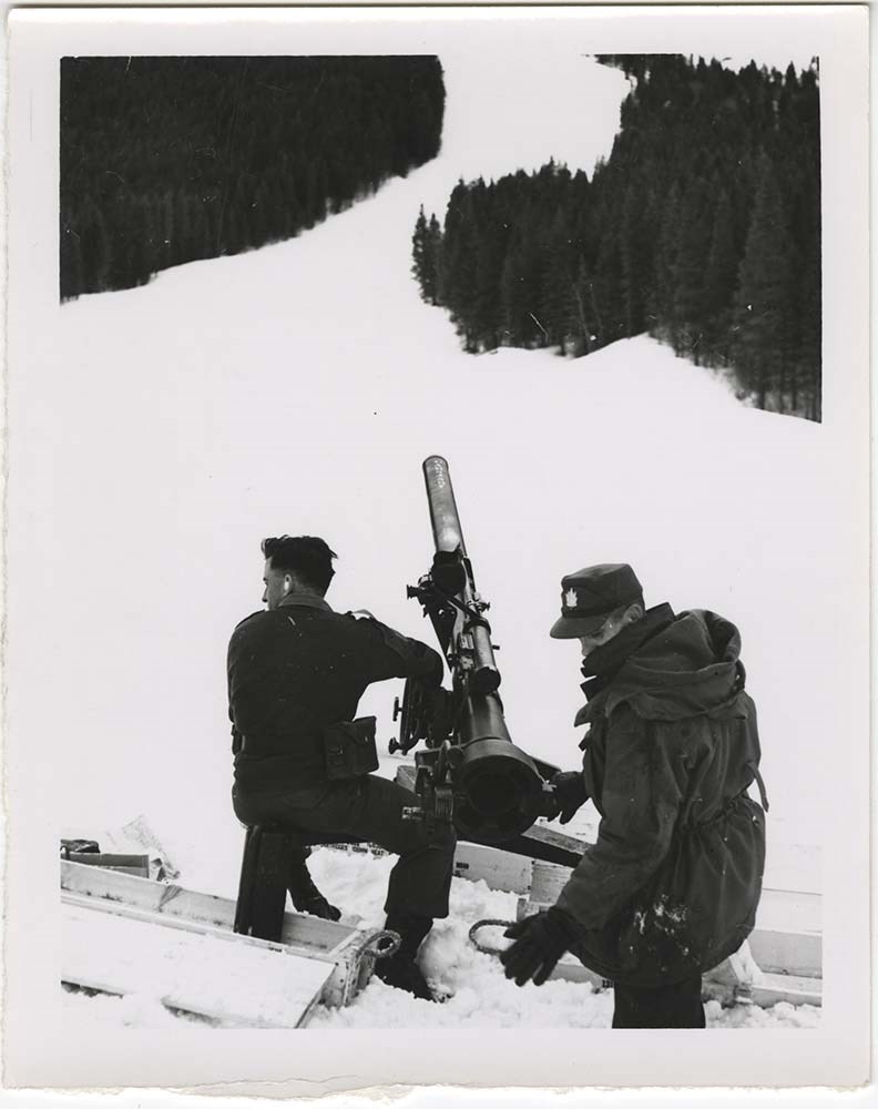
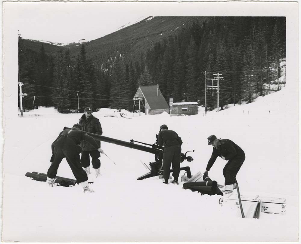
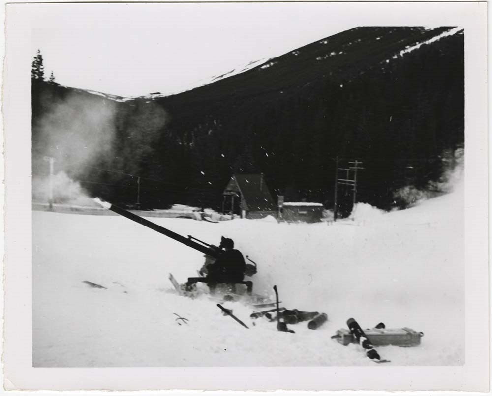
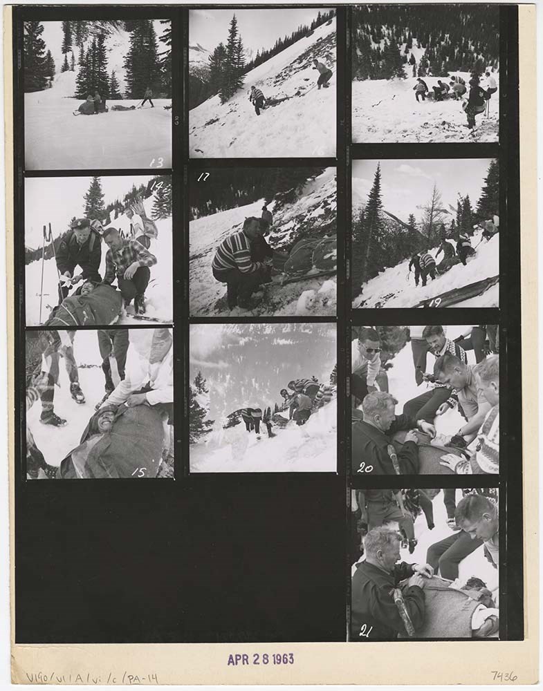
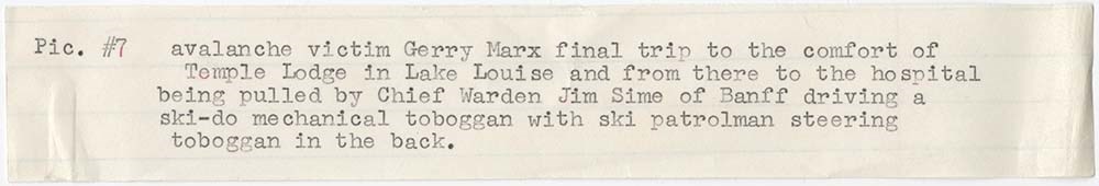
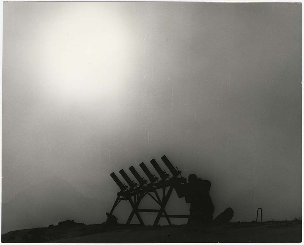
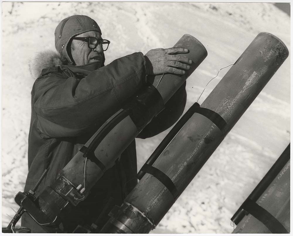
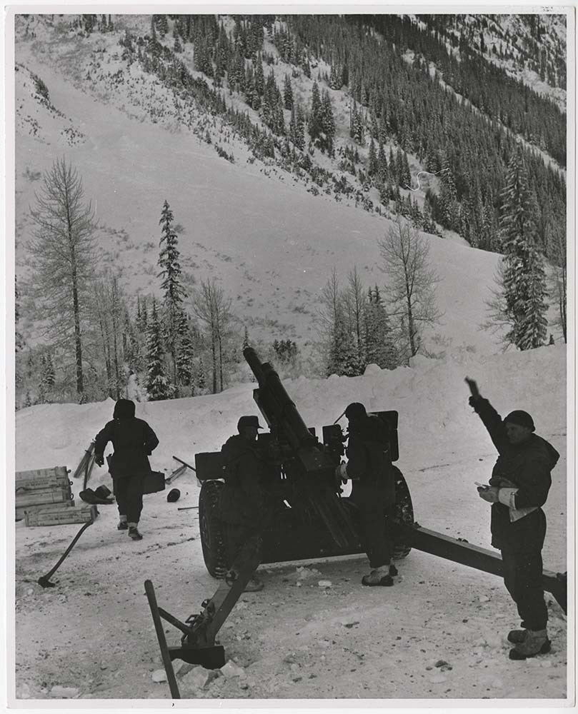
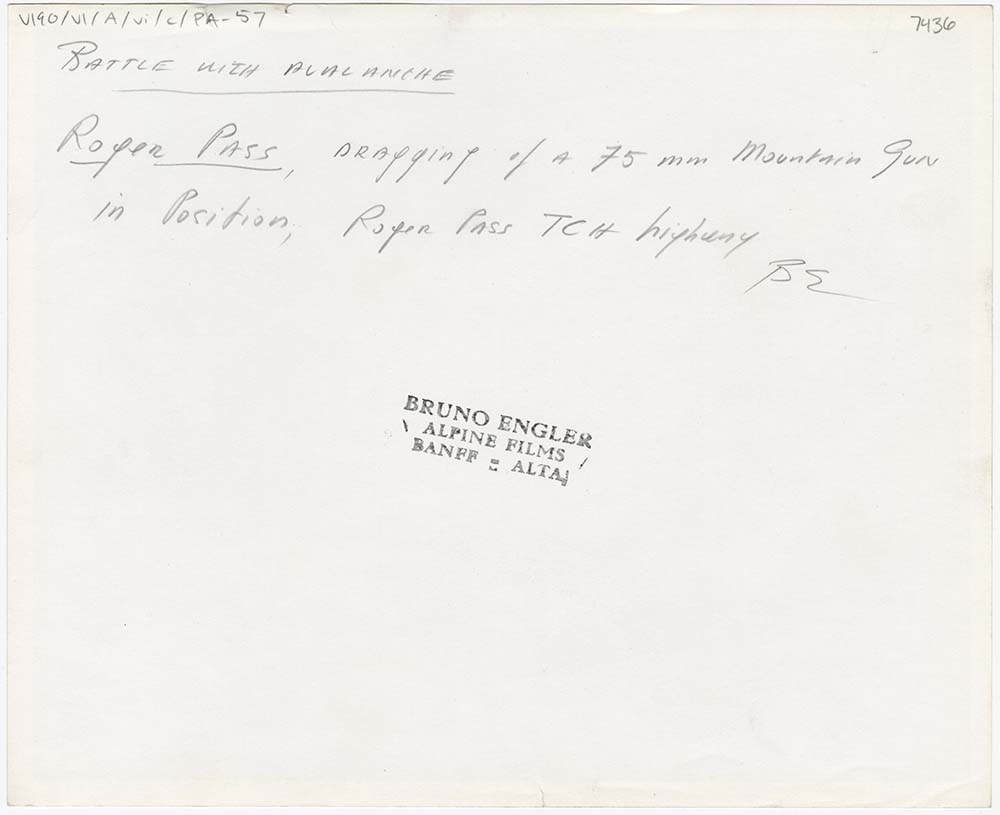
Avalanche Control [1/2]
https://archives.whyte.org/en/permalink/descriptions56748
- Part Of
- Bruno Engler fonds
- Scope & Content
- File pertains to 62 b&w prints of various avalanche control operations around Banff National Park, usually along highways and around ski hills. Also includes photographs from a rescue operation and accompanying news clippings pertaining to that rescue.
- Date Range
- 1956-1979
- Reference Code
- V190 / VI / A / vi / c / PA - 01 to PA - 62
- Description Level
- 5 / File
- GMD
- Photograph
17 images
- Part Of
- Bruno Engler fonds
- Description Level
- 5 / File
- Fonds Number
- M323 / S40 / V190
- Series
- VI : Retained file, A : Alphabetical order
- Sous-Fonds
- V190
- Sub-Series
- vi : Avalanches, c : Control
- Accession Number
- 7436
- Reference Code
- V190 / VI / A / vi / c / PA - 01 to PA - 62
- GMD
- Photograph
- Date Range
- 1956-1979
- Physical Description
- 62 photographs : b&w ; 20.3 x 25.4 cm or smaller
- History / Biographical
- See fonds level description
- Scope & Content
- File pertains to 62 b&w prints of various avalanche control operations around Banff National Park, usually along highways and around ski hills. Also includes photographs from a rescue operation and accompanying news clippings pertaining to that rescue.
- Notes
- Photographs included in this entry were originally housed in a photo paper box identified by Bruno Engler prior to accessioning.
- Subject Access
- Aerial photography
- Avalanches
- Banff-Jasper Highway
- Lake Louise Ski Area
- Mountains
- Rescue
- Rogers Pass
- Ski areas
- Sunshine Ski Resort
- Winter
- Geographic Access
- Banff National Park
- Jasper National Park
- Alberta
- Language
- English
- Conservation
- PA - 25 has two overlapping pieces of masking tape on the back, holding the two torn pieces of the print together
- Creator
- Engler, Bruno
- Title Source
- Original title kept
- Processing Status
- Processed
Images


This material is presented as originally created; it may contain outdated cultural descriptions and
potentially offensive content.
Read more.
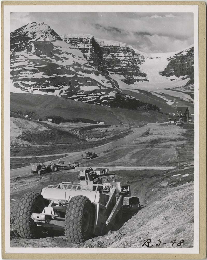
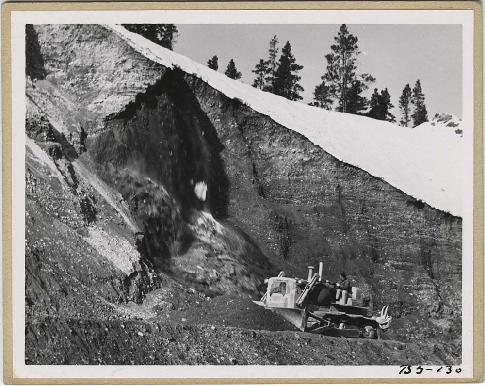
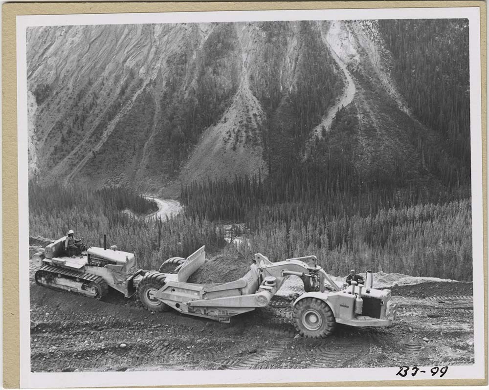
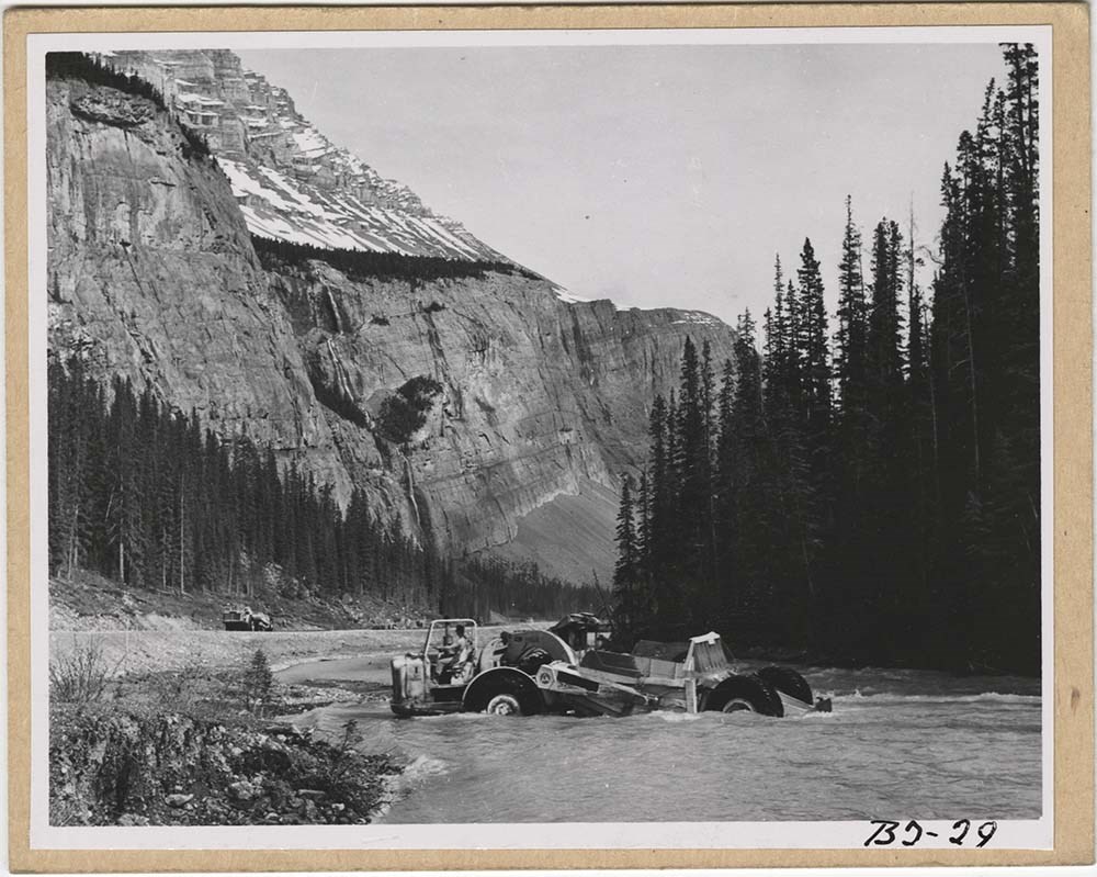
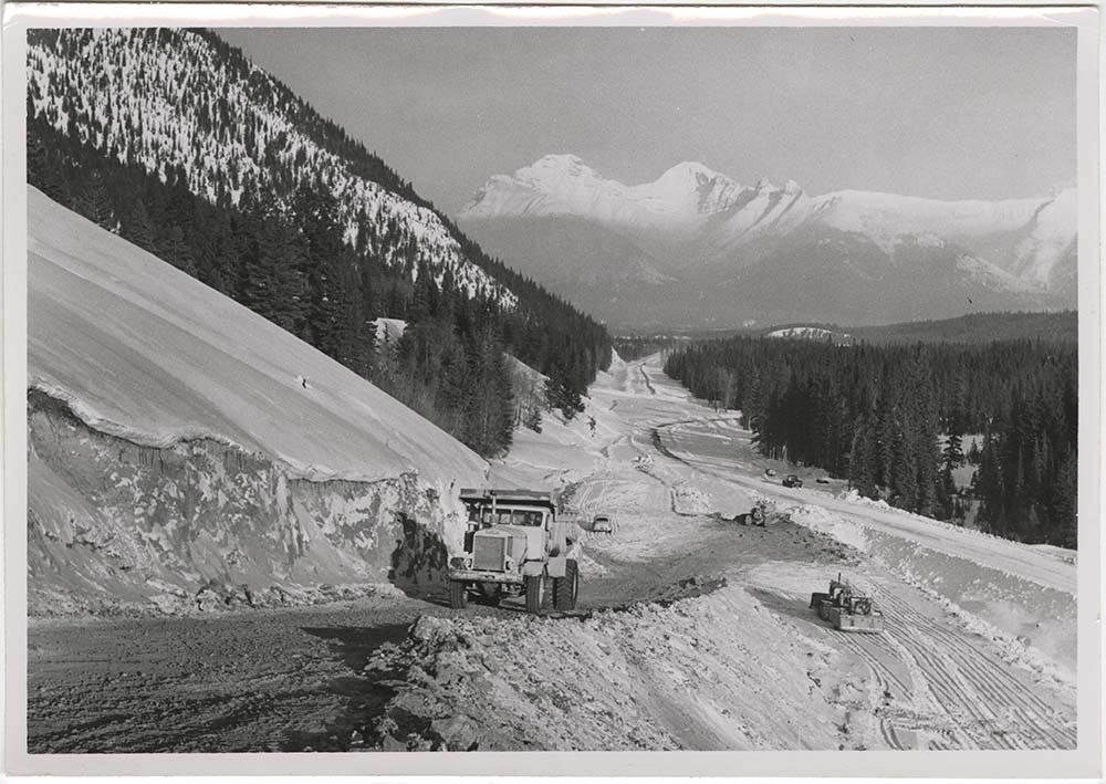
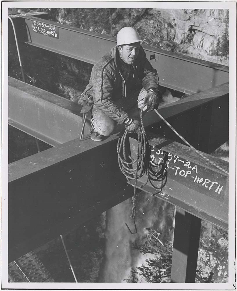
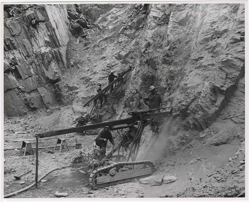
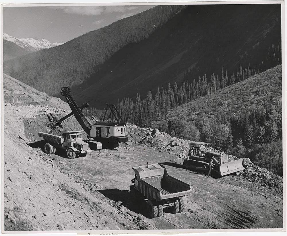
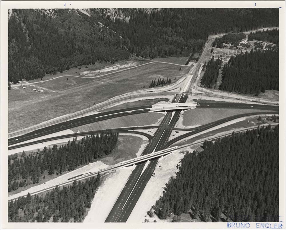
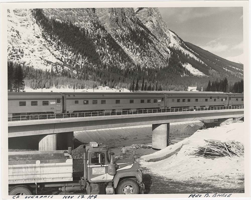
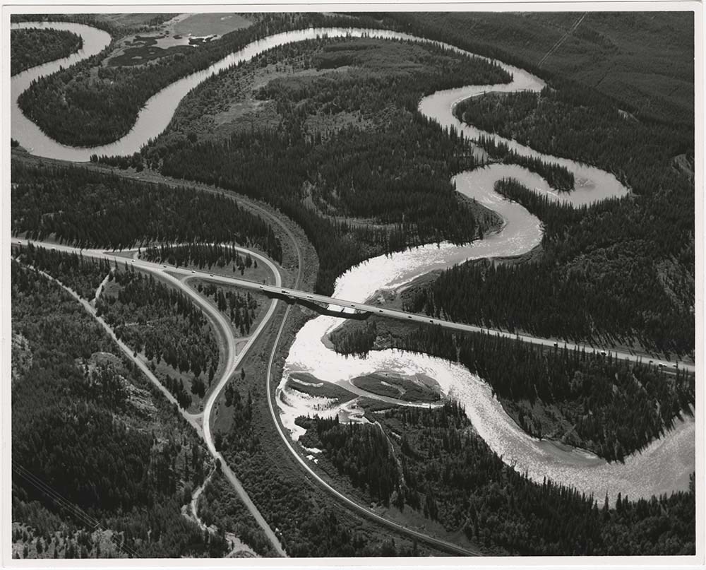
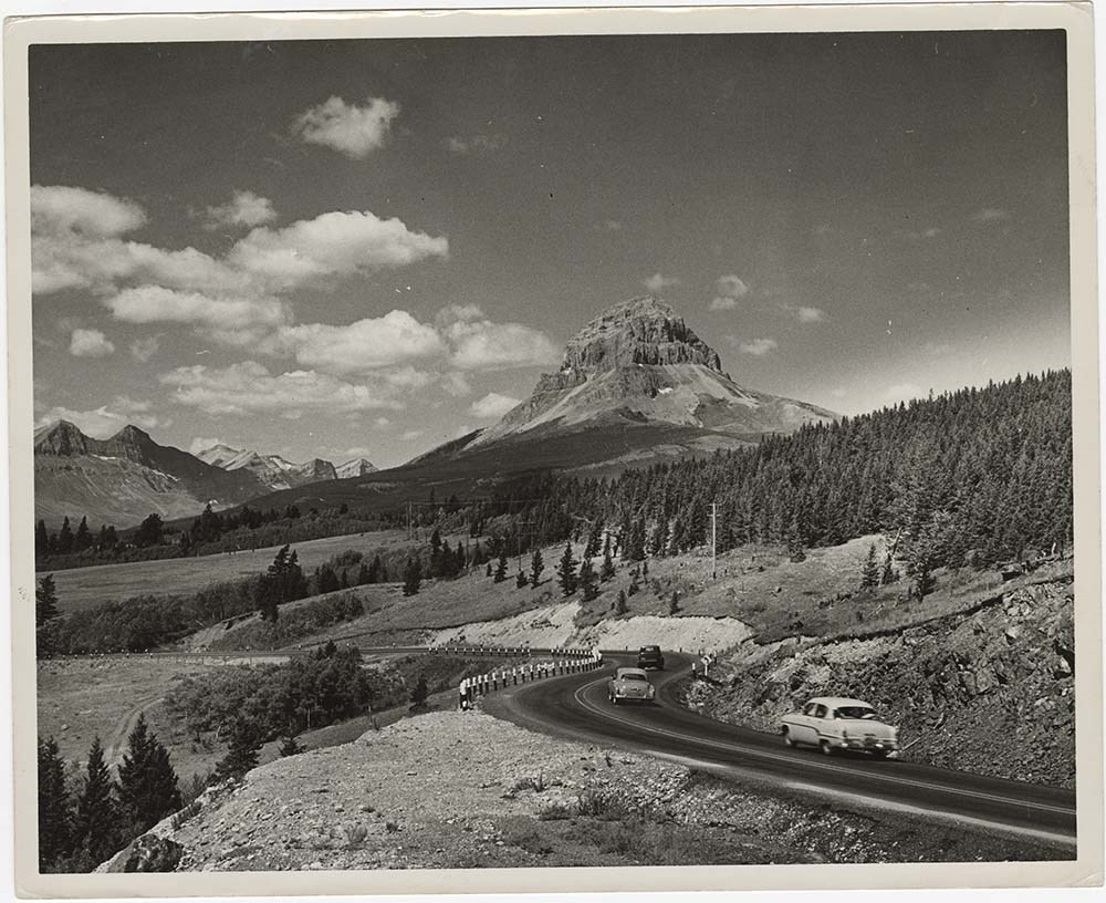
Road Constructions
https://archives.whyte.org/en/permalink/descriptions57427
- Part Of
- Bruno Engler fonds
- Scope & Content
- File pertains to 62 b&w prints of construction of the Banff-Jasper Highway [the Icefield Parkway], as well as a few shots of the Trans-Canada Highway construction just west of the town of Banff.
- Date Range
- 1957-1962
- Reference Code
- V190 / VI / R / ii / b / PA - 01 to PA - 62
- Description Level
- 5 / File
- GMD
- Photograph
14 images
- Part Of
- Bruno Engler fonds
- Description Level
- 5 / File
- Fonds Number
- M323 / S40 / V190
- Series
- VI : Retained file, R : Alphabetical order
- Sous-Fonds
- V190
- Sub-Series
- ii : Roads, b : Construction
- Accession Number
- 7436
- Reference Code
- V190 / VI / R / ii / b / PA - 01 to PA - 62
- GMD
- Photograph
- Date Range
- 1957-1962
- Physical Description
- 62 photographs : b&w ; 25.2 x 20.2 cm or smaller
- History / Biographical
- See fonds level description
- Scope & Content
- File pertains to 62 b&w prints of construction of the Banff-Jasper Highway [the Icefield Parkway], as well as a few shots of the Trans-Canada Highway construction just west of the town of Banff.
- Subject Access
- Athabasca Glacier
- Banff-Jasper Highway
- Bridges
- Construction
- Glaciers
- Mountains
- Trans-Canada Highway
- Roads
- Geographic Access
- Banff
- Banff National Park
- Jasper National Park
- Alberta
- Language
- English
- Creator
- Engler, Bruno
- Title Source
- Original title kept
- Processing Status
- Processed
Images


This material is presented as originally created; it may contain outdated cultural descriptions and
potentially offensive content.
Read more.
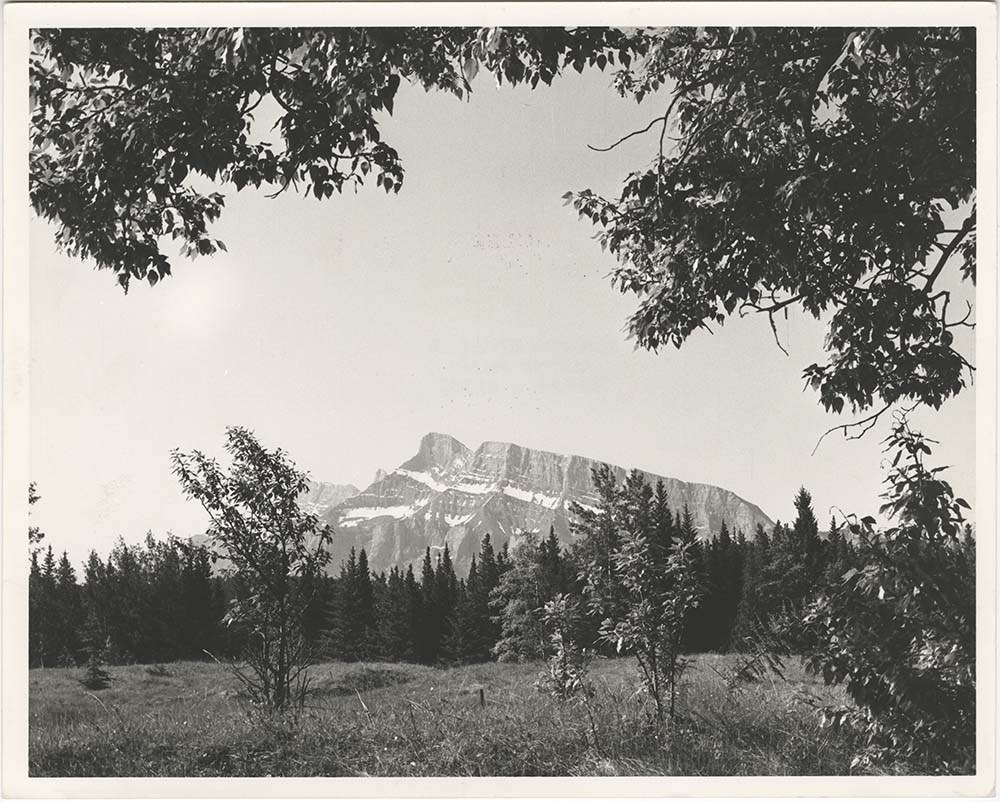
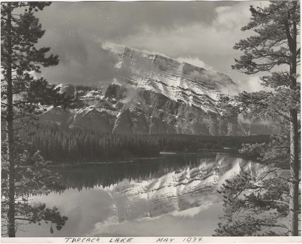
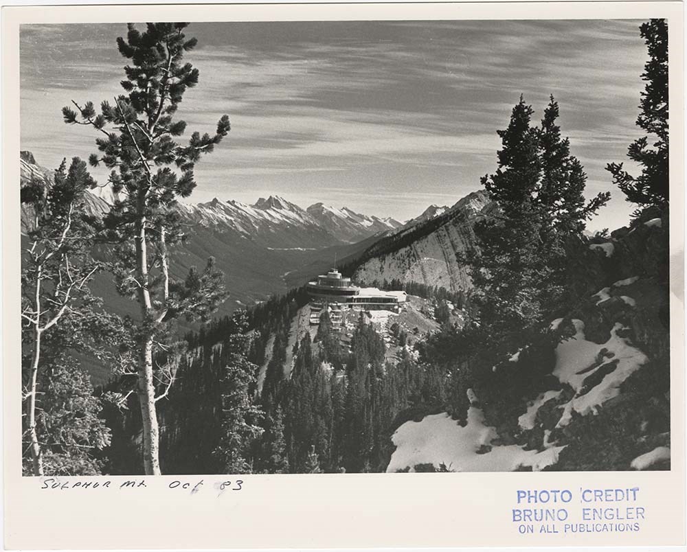
- Part Of
- Bruno Engler fonds
- Scope & Content
- File pertains to 40 b&w prints of various scenic views from throught the Canadian Rockies. Includes several mountains [including Rundle, Cascade, Mount Lougheed, Ha Ling, Sulphur ], lakes [including Two Jack, Vermillion, Bow, Peyto, and Waterton], and various other views like highways, rivers, hood…
- Date Range
- [ca. 1950-1988]
- Reference Code
- V190 / VI / S / i / PA - 01 to PA - 40
- Description Level
- 5 / File
- GMD
- Photograph
10 images
- Part Of
- Bruno Engler fonds
- Description Level
- 5 / File
- Fonds Number
- M323 / S40 / V190
- Series
- VI : Retained file, S : Alphabetical order
- Sous-Fonds
- V190
- Sub-Series
- i : Scenic Park
- Accession Number
- 7436
- Reference Code
- V190 / VI / S / i / PA - 01 to PA - 40
- GMD
- Photograph
- Date Range
- [ca. 1950-1988]
- Physical Description
- 40 photographs : b&w ; 25.2 x 20.2 cm or smaller
- History / Biographical
- See fonds level description
- Scope & Content
- File pertains to 40 b&w prints of various scenic views from throught the Canadian Rockies. Includes several mountains [including Rundle, Cascade, Mount Lougheed, Ha Ling, Sulphur ], lakes [including Two Jack, Vermillion, Bow, Peyto, and Waterton], and various other views like highways, rivers, hoodoos, tunnels, and valleys.
- Subject Access
- Automobiles
- Banff townsite
- Banff-Jasper Highway
- Bow River
- Bow Valley
- Cascade Mountain
- Cascades of Time Garden
- Fishing
- Glaciers
- Hoodoos
- Icefield Parkway
- Mountains
- North Saskatchewan River
- Rivers
- Roads
- Rundle Mountain
- scenic
- Sulphur Mountain
- Sulphur Mountain Gondola
- Trans-Canada Highway
- Two Jack Lake
- Geographic Access
- Banff
- Bow Lake
- Peyto Lake
- Banff National Park
- Jasper National Park
- Waterton
- Alberta
- Bugaboos
- British Columbia
- Language
- English
- Creator
- Engler, Bruno
- Title Source
- Original title kept
- Processing Status
- Processed
Images


This material is presented as originally created; it may contain outdated cultural descriptions and
potentially offensive content.
Read more.
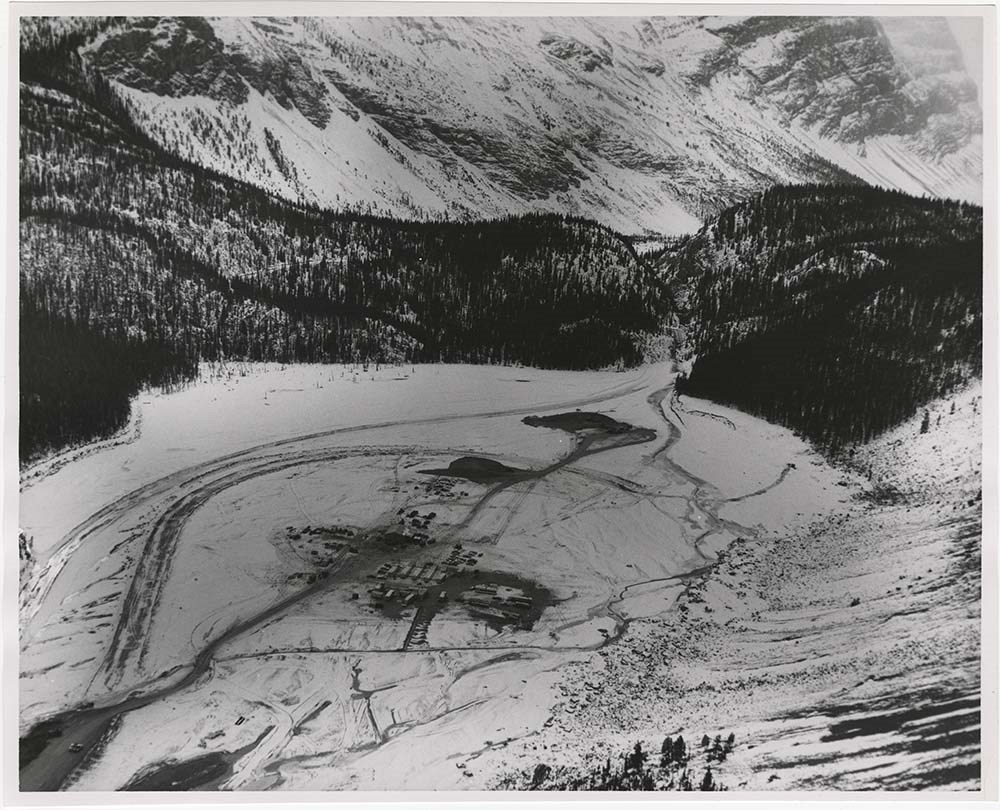
Avalanche Control [2/2]
https://archives.whyte.org/en/permalink/descriptions57495
- Part Of
- Bruno Engler fonds
- Scope & Content
- File pertains to 6 boards with b&w negative contact sheets adhered to them depicting various areas prone to avalanches taken from a plane or helicopter. Includes views of ski areas and roads.
- Date Range
- 1956-1979
- Reference Code
- V190 / VI / A / vi / c / PA - 63 to PA - 68
- Description Level
- 5 / File
- GMD
- Photograph
- Part Of
- Bruno Engler fonds
- Description Level
- 5 / File
- Fonds Number
- M323 / S40 / V190
- Series
- VI : Retained file, A : Alphabetical order
- Sous-Fonds
- V190
- Sub-Series
- vi : Avalanches, c : Control
- Accession Number
- 7436
- Reference Code
- V190 / VI / A / vi / c / PA - 63 to PA - 68
- GMD
- Photograph
- Date Range
- 1956-1979
- Physical Description
- 6 photographs : b&w ; 23.4 x 34.2 cm or smaller
- History / Biographical
- See fonds level description
- Scope & Content
- File pertains to 6 boards with b&w negative contact sheets adhered to them depicting various areas prone to avalanches taken from a plane or helicopter. Includes views of ski areas and roads.
- Notes
- File came from box XVI, separate from alphabetised boxes
- Subject Access
- Aerial photography
- Avalanches
- Banff-Jasper Highway
- Lake Louise Ski Area
- Mountains
- Rescue
- Rogers Pass
- Ski areas
- Sunshine Ski Resort
- Winter
- Geographic Access
- Banff National Park
- Jasper National Park
- Alberta
- Language
- English
- Creator
- Engler, Bruno
- Title Source
- Original title kept
- Processing Status
- Processed
This material is presented as originally created; it may contain outdated cultural descriptions and
potentially offensive content.
Read more.
Our Heritage: A Series of Historical Sketches of Alberta
https://archives.whyte.org/en/permalink/descriptions54753
- Part Of
- Luxton family fonds
- Scope & Content
- File consists of a portfolio containing a map of Alberta and published textual record titled "Our Heritage: A Series of Historical Sketches of Alberta by John Fisher". Content pertains to accounts by John Fisher from his travels in Alberta, including Calgary and Jasper National Park. Front cover of…
- Date Range
- [1955-1960]
- Reference Code
- LUX / II / F1 / 38
- Description Level
- 5 / File
- GMD
- Textual record
- Published record
- Map
- Part Of
- Luxton family fonds
- Description Level
- 5 / File
- Fonds Number
- LUX
- Series
- LUX / II / F : Collected material
- Sous-Fonds
- LUX / II : Eleanor Luxton sous-fonds
- Sub-Series
- LUX / II / F1 : Textual
- Accession Number
- LUX
- Reference Code
- LUX / II / F1 / 38
- Date Range
- [1955-1960]
- Physical Description
- 1 cm of textual records
- Scope & Content
- File consists of a portfolio containing a map of Alberta and published textual record titled "Our Heritage: A Series of Historical Sketches of Alberta by John Fisher". Content pertains to accounts by John Fisher from his travels in Alberta, including Calgary and Jasper National Park. Front cover of portfolio is annotated in red ink with the name "Bessie L.[?] MacKay".
- Name Access
- Fisher, John
- MacKay, Bessie
- Subject Access
- History
- Businesses
- Commerce and industry
- Community events
- Hotel
- Palliser Hotel
- Winter sports
- Sports
- Skiing
- Biography
- Parks
- Geographic Access
- Canada
- Alberta
- Calgary
- Jasper National Park
- Reproduction Restrictions
- Restrictions may apply
- Language
- English
- Title Source
- Title copied from item in file
- Processing Status
- Processed
This material is presented as originally created; it may contain outdated cultural descriptions and
potentially offensive content.
Read more.
Travel guides and maps
https://archives.whyte.org/en/permalink/descriptions56361
- Part Of
- Ben Gadd fonds
- Scope & Content
- Sub-series consists of travel brochures and maps which were collected and used by Ben Gadd. Sub-series contains five sub-sub series: M590 / I / A / i : Travel guides and pocket maps M590 / I / A / ii : Topographical maps M590 / I / A / iii : Geological maps M590 / I / A / iv : Highway maps M590 / …
- Date Range
- [ca.1920-2010]
- Reference Code
- M590 / I / A
- Description Level
- 4 / Sub-series
- GMD
- Map
- Textual record
- Part Of
- Ben Gadd fonds
- Description Level
- 4 / Sub-series
- Fonds Number
- M590
- V810
- S61
- Series
- M590 / I : Personal records
- Sous-Fonds
- M590
- Sub-Series
- M590 / I / A : Travel guides and maps
- Accession Number
- 2021.20
- Reference Code
- M590 / I / A
- GMD
- Map
- Textual record
- Date Range
- [ca.1920-2010]
- Physical Description
- ca. 274 maps -- ca. 61 travel guides, brochures
- Scope & Content
- Sub-series consists of travel brochures and maps which were collected and used by Ben Gadd. Sub-series contains five sub-sub series: M590 / I / A / i : Travel guides and pocket maps M590 / I / A / ii : Topographical maps M590 / I / A / iii : Geological maps M590 / I / A / iv : Highway maps M590 / I / A / v : Index maps, other
- Notes
- Some materials in sub-series are annotated with notes by Ben Gadd
- Name Access
- Gadd, Ben
- Subject Access
- Geography
- Geology
- Environment
- Map
- Tourism
- Tourist information
- Travel
- Trails
- Roads
- Transportation
- Natural history
- National parks and reserves
- Provincial parks and reserves
- Government
- Sports
- Recreation
- Hiking
- Geographic Access
- Canada
- Alberta
- British Columbia
- Banff National Park
- Jasper National Park
- Kootenay National Park
- Yoho National Park
- Waterton Lakes National Park
- Columbia Icefields
- United States of America
- Colorado
- Montana
- Yellowstone National Park
- Access Restrictions
- Restrictions may apply - some materials are fragile
- Reproduction Restrictions
- Restrictions may apply
- Language
- English
- Conservation
- Some fragile/torn materials stored in mylar
- Category
- Environment
- Exploration, discovery and travel
- Government
- Sports, recreation and leisure
- Transportation
- Tourism
- Title Source
- Title based on contents of sub-series
- Processing Status
- Processed
This material is presented as originally created; it may contain outdated cultural descriptions and
potentially offensive content.
Read more.