3559 records – page 1 of 178.
Maps of exploration survey of divide between Great Slave Lake ...
Showing rivers and Indian trails
Drainage Patterns
Map showing Yellowhead Pass route from Edmonton to Tete-Jaune Cache
[Yukon District] Klondike Gold Fields
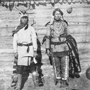
Adam Poucette? (left) [1900]
Travel 1900
Showing part of the Summit Range of the Canadian Rocky ...
[Index to Top. Sheets of Rocky Mountains]
[Yoho Park Reserve]
[Canada] National Transcontinental Railway route
Map of the Selkirks from a photographic survey by A.O. ...
Map showing exploration between Lakes Winnipeg, Manitoba and Winnipegosis
Travel 1902
Topographical map
Travel 1903
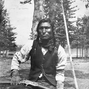
Morley Beaver and John House (Suwatâga Ktûze), Stoney Nakoda
John Abraham or Jonas Benjamin, Stoney Nakoda
![Cover image of Adam Poucette? (left) [1900]](/media/archives/Recognizing Relations/Jpegs/V701 jpegs/v701_lc_272.jpg?width=180&height=180&mode=crop&anchor=topcenter&404=no-img.jpg)