9291 records – page 1 of 465.
Central British Columbia
Classical Lands of the Mediterranean
Map showing how population of Europe is divided nationally and ...
[Banff - Sketch plan of Banff townsite]
Norquay, ski racers and activities. -- [ca.1940, n.d.].
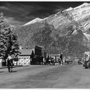
Banff Avenue. -- [ca.1940]
Banff Avenue, winter. -- [ca.1940]
Banff Avenue, Winter. -- [ca.1940]
Bow River Bridge, Banff view to Cascade Mountain. -- [ca.1940]
Bow Valley, view west. -- [ca.1940]
Banff Avenue - looking north
[Moose Mountain 82 J/15 West - Alberta]
[British Columbia, Highways] Alberta Motor Association
[United States] And neighbouring Canadian Provinces
Soil rating map of Rosebud and portion of Banff sheets
Yoho Valley Area
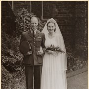
Unidentified couple
Cascade Development Sketch Plan of the Ghost River Diversion
Canal topography from Lake Minnewanka to the sink.
![Cover image of Norquay, ski racers and activities. -- [ca.1940, n.d.].](/media/archives/v108_harmon_lloyd_web/v108_i_na_1403.jpg?width=180&height=180&mode=crop&anchor=topcenter&404=no-img.jpg)
![Cover image of Banff Avenue. -- [ca.1940]](/media/archives/v469_noble_web/v469_iii_web/v469_iii_na_3605.jpg?width=180&height=180&mode=crop&anchor=topcenter&404=no-img.jpg)
![Cover image of Banff Avenue, winter. -- [ca.1940]](/media/archives/v469_noble_web/v469_iii_web/v469_iii_na_3606.jpg?width=180&height=180&mode=crop&anchor=topcenter&404=no-img.jpg)
![Cover image of Banff Avenue, Winter. -- [ca.1940]](/media/archives/v469_noble_web/v469_iii_web/v469_iii_na_3607.jpg?width=180&height=180&mode=crop&anchor=topcenter&404=no-img.jpg)
![Cover image of Banff Avenue, Winter. -- [ca.1940]](/media/archives/v469_noble_web/v469_iii_web/v469_iii_na_3608.jpg?width=180&height=180&mode=crop&anchor=topcenter&404=no-img.jpg)
![Cover image of Bow River Bridge, Banff view to Cascade Mountain. -- [ca.1940]](/media/archives/v469_noble_web/v469_iii_web/v469_iii_na_3609.jpg?width=180&height=180&mode=crop&anchor=topcenter&404=no-img.jpg)
![Cover image of Bow Valley, view west. -- [ca.1940]](/media/archives/v469_noble_web/v469_iii_web/v469_iii_na_3610.jpg?width=180&height=180&mode=crop&anchor=topcenter&404=no-img.jpg)