9349 records – page 1 of 468.
Outline of slave-holding States
British Columbia
[British North America]
Seat of war
A general map of the routes in British North America ...
French map showing various districts
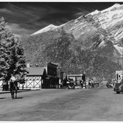
Banff Avenue - looking north
Norquay, ski racers and activities. -- [ca.1940, n.d.].
Map showing how population of Europe is divided nationally and ...
[Banff - Sketch plan of Banff townsite]
Central British Columbia
Banff Avenue. -- [ca.1940]
Banff Avenue, winter. -- [ca.1940]
Banff Avenue, Winter. -- [ca.1940]
Bow River Bridge, Banff view to Cascade Mountain. -- [ca.1940]
Bow Valley, view west. -- [ca.1940]
Preliminary map: George Creek, Alberta
Geological survey [Keremeos - Similkameen District]
Classical Lands of the Mediterranean
![Cover image of Norquay, ski racers and activities. -- [ca.1940, n.d.].](/media/archives/v108_harmon_lloyd_web/v108_i_na_1403.jpg?width=180&height=180&mode=crop&anchor=topcenter&404=no-img.jpg)
![Cover image of Banff Avenue. -- [ca.1940]](/media/archives/v469_noble_web/v469_iii_web/v469_iii_na_3605.jpg?width=180&height=180&mode=crop&anchor=topcenter&404=no-img.jpg)
![Cover image of Banff Avenue, winter. -- [ca.1940]](/media/archives/v469_noble_web/v469_iii_web/v469_iii_na_3606.jpg?width=180&height=180&mode=crop&anchor=topcenter&404=no-img.jpg)
![Cover image of Banff Avenue, Winter. -- [ca.1940]](/media/archives/v469_noble_web/v469_iii_web/v469_iii_na_3607.jpg?width=180&height=180&mode=crop&anchor=topcenter&404=no-img.jpg)
![Cover image of Banff Avenue, Winter. -- [ca.1940]](/media/archives/v469_noble_web/v469_iii_web/v469_iii_na_3608.jpg?width=180&height=180&mode=crop&anchor=topcenter&404=no-img.jpg)
![Cover image of Bow River Bridge, Banff view to Cascade Mountain. -- [ca.1940]](/media/archives/v469_noble_web/v469_iii_web/v469_iii_na_3609.jpg?width=180&height=180&mode=crop&anchor=topcenter&404=no-img.jpg)
![Cover image of Bow Valley, view west. -- [ca.1940]](/media/archives/v469_noble_web/v469_iii_web/v469_iii_na_3610.jpg?width=180&height=180&mode=crop&anchor=topcenter&404=no-img.jpg)