54 records – page 1 of 3.
Topographical sheet
(a): Topographical sheets|(b): Original map
Topographical Sheet
Plan shewing the C.A.C. Coy's coal land, Bow River Valley
North West Territories
(Bow Lake Area)
A surface geology map of New Brunswick
(part of Bow River)
(Castle Mountain Area)
(part of Bow river)
Map of the Kootenay region to accompany report of Supt. ...
Electoral Districts for the Legislative Assembly and the Railroad System
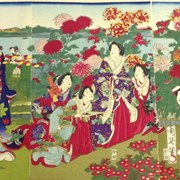
Viewing of Chrysanthemums at the Temporary Imperial Palace
Range 1, West of Fifth Meridian
Range 1, West of Fifth Meridian, Red Deer-Little Red Deer ...
Plan of the town of Anthracite. Being portions of N1/2. ...
Geological map [Vancouver Island], Northern part of Vancouver Island and ...
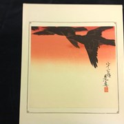
Crows in Flight
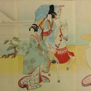
Lady Nalih’la Going Down to the East