Narrow Results By
- Catharine Robb Whyte, O. C. (1906 – 1979, Canadian) 29
- Robert William Sinclair (1939 – , Canadian) 21
- Charles John Collings (1848 – 1931, British) 18
- Peter Whyte (1905 – 1966, Canadian) 9
- Catherine Perehudoff Fowler (1958 – , Canadian) 2
- Serena Matilda Potts (1812 – 1898, American) 2
- Adeline Baxter (1881 – 1959) 1
- Bern Smith (1928 – 2009, Canadian) 1
- Chalifour, J.E., Chief Geographer 1
- Ernest C. W Lamarque (1879 – 1970, Canadian) 1
- Louis Agassiz Fuertes (1874 – 1927, American) 1
- National Museum of Ethnology 1
Alberta : Athabaska sheet
https://archives.whyte.org/en/permalink/catalogue24415
- Medium
- Library - Maps and blueprints (unannotated; published)
- Map
- Published Date
- 1914
- Publisher
- Ottawa: Office of the Surveyor General
- Edition
- 2d ed.
- Call Number
- C9-2.4
- Edition
- 2d ed.
- Publisher
- Ottawa: Office of the Surveyor General
- Published Date
- 1914
- Physical Description
- 1 map
- Scale
- Scale: 1:190,080
- Subjects
- Athabaska River
- Notes
- Sectional map
- Accession Number
- 5576
- 4008
- Call Number
- C9-2.4
- Collection
- Archives Library
This material is presented as originally created; it may contain outdated cultural descriptions and
potentially offensive content.
Read more.
Alberta endangered wilderness / Alberta Wilderness Association
https://archives.whyte.org/en/permalink/catalogue21409
- Medium
- Library - Maps and blueprints (unannotated; published)
- Map
- Published Date
- 1990
- Publisher
- [Calgary?] : The Association
- Call Number
- C9-5.19
- Publisher
- [Calgary?] : The Association
- Published Date
- 1990
- Physical Description
- 1 map : col
- Accession Number
- SL 94B24KXP
- Call Number
- C9-5.19
- Collection
- Archives Library
This material is presented as originally created; it may contain outdated cultural descriptions and
potentially offensive content.
Read more.
Alberta road map
https://archives.whyte.org/en/permalink/catalogue24410
- Medium
- Library - Maps and blueprints (unannotated; published)
- Map
- Published Date
- 1990
- Publisher
- Edmonton : Alberta Tourism
- Call Number
- C9-1.20
- Publisher
- Edmonton : Alberta Tourism
- Published Date
- 1990
- Physical Description
- 14 maps on 1 sheet
- Scale
- Scale: 1:500,000
- Subjects
- Alberta
- Notes
- Province of Alberta, Canada 1990 official road map
- Cover title: Alberta road map
- Maps of principal towns and cities on reverse
- Info file transfer
- Call Number
- C9-1.20
- Collection
- Archives Library
This material is presented as originally created; it may contain outdated cultural descriptions and
potentially offensive content.
Read more.
[Alberta] South-central portion
https://archives.whyte.org/en/permalink/catalogue24416
- Medium
- Library - Maps and blueprints (unannotated; published)
- Map
- Published Date
- 1910
- Publisher
- Dept. of the Interior, Ottawa
- Call Number
- C9-3.1
- Publisher
- Dept. of the Interior, Ottawa
- Published Date
- 1910
- Scale
- Bench marks
- Subjects
- Alberta
- Notes
- 1 duplicate in map room - Accn. 400
- Accession Number
- 400
- Call Number
- C9-3.1
- Collection
- Archives Library
This material is presented as originally created; it may contain outdated cultural descriptions and
potentially offensive content.
Read more.
- Date
- 1994
- Medium
- watercolour sumi-e on rice paper
- Catalogue Number
- SiR.05.59
- Description
- A thin green stem extends upwards from the bottom centre. Three red sketchy blooms extend from the bloom at the top. At the bottom there are three red stamps.
1 image
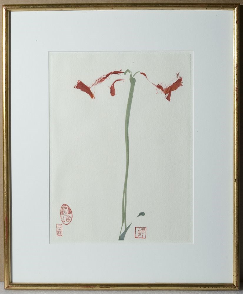
- Title
- Amaryllis #6
- Date
- 1994
- Medium
- watercolour sumi-e on rice paper
- Dimensions
- 30.5 x 22.8 cm
- Description
- A thin green stem extends upwards from the bottom centre. Three red sketchy blooms extend from the bloom at the top. At the bottom there are three red stamps.
- Credit
- Gift of Robert William Sinclair, Edmonton, 2010
- Catalogue Number
- SiR.05.59
Images
This material is presented as originally created; it may contain outdated cultural descriptions and
potentially offensive content.
Read more.
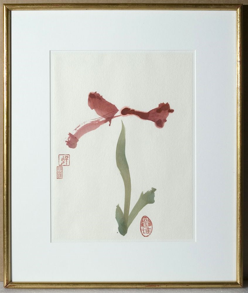
- Date
- 1994
- Medium
- watercolour on rice paper
- Catalogue Number
- SiR.05.69
- Description
- A thin green stem extends upwards from the bottom centre. Three red sketchy blooms extend from the bloom at the top. At the bottom there are three red stamps.
1 image
- Title
- Amaryllis #9
- Date
- 1994
- Medium
- watercolour on rice paper
- Dimensions
- 30.4 x 22.7 cm
- Description
- A thin green stem extends upwards from the bottom centre. Three red sketchy blooms extend from the bloom at the top. At the bottom there are three red stamps.
- Subject
- landscape
- Credit
- Gift of Robert William Sinclair, Edmonton, 2010
- Catalogue Number
- SiR.05.69
Images
This material is presented as originally created; it may contain outdated cultural descriptions and
potentially offensive content.
Read more.
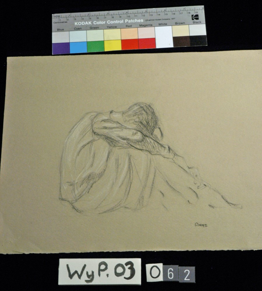
- Date
- 1916 – 1927
- Medium
- charcoal; pastel; on paper
- Catalogue Number
- WyP.03.062
- Description
- Person sitting with head bent over raised knees.
1 image
- Title
- Anne
- Date
- 1916 – 1927
- Medium
- charcoal; pastel; on paper
- Dimensions
- 26.4 x 33.3 cm
- Description
- Person sitting with head bent over raised knees.
- Credit
- Gift of Catharine Robb Whyte, O. C., Banff, 1975
- Catalogue Number
- WyP.03.062
Images
This material is presented as originally created; it may contain outdated cultural descriptions and
potentially offensive content.
Read more.
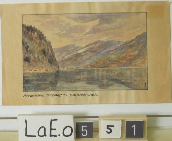
Approaching Stewart B.C. Portland Canal
https://archives.whyte.org/en/permalink/artifactlae.05.51
- Date
- 1919
- Medium
- watercolour on paper
- Catalogue Number
- LaE.05.51
1 image
- Title
- Approaching Stewart B.C. Portland Canal
- Date
- 1919
- Medium
- watercolour on paper
- Dimensions
- 8.7 x 14.1 cm
- Credit
- Gift of Ernest Lamarque (Estate), 1971
- Catalogue Number
- LaE.05.51
Images
This material is presented as originally created; it may contain outdated cultural descriptions and
potentially offensive content.
Read more.
Athabasca Falls : Improvement District 12 Alberta
https://archives.whyte.org/en/permalink/catalogue24240
- Medium
- Library - Maps and blueprints (unannotated; published)
- Map
- Published Date
- 1996
- Publisher
- Ottawa : Natural Resources Canada
- Edition
- 3 ed
- Call Number
- NTS
- 83 C12
- Edition
- 3 ed
- Publisher
- Ottawa : Natural Resources Canada
- Published Date
- 1996
- Physical Description
- 1 map : col
- Scale
- Scale: 1:50,000
- Relief: contour interval 20 metres below 2000 metres, 40 metres above 2000 metres
- Accession Number
- 30500 3.2.98
- Call Number
- NTS
- 83 C12
- Collection
- Archives Library
This material is presented as originally created; it may contain outdated cultural descriptions and
potentially offensive content.
Read more.
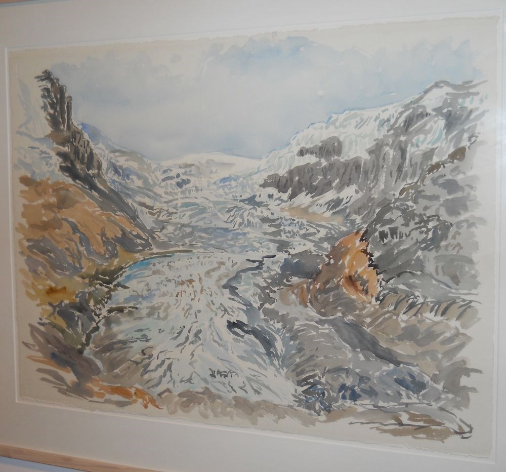
Athabasca Glacier
https://archives.whyte.org/en/permalink/artifactpec.05.01
- Date
- 1993
- Medium
- watercolour on paper
- Catalogue Number
- PeC.05.01
- Description
- The glacier is centred top, flowing down to the foreground, flanked on both sides by the mountain in colours of brown, yellow, grey, green. The light blue sky is cloudy.
1 image
- Title
- Athabasca Glacier
- Date
- 1993
- Medium
- watercolour on paper
- Dimensions
- 56.0 x 76.0 cm
- Description
- The glacier is centred top, flowing down to the foreground, flanked on both sides by the mountain in colours of brown, yellow, grey, green. The light blue sky is cloudy.
- Credit
- Purchased from Catherine Perehudoff Fowler, Saskatoon, 1994
- Catalogue Number
- PeC.05.01
Images
This material is presented as originally created; it may contain outdated cultural descriptions and
potentially offensive content.
Read more.
Athabasca Pass : British Columbia Alberta Colombie-Britannique Alberta
https://archives.whyte.org/en/permalink/catalogue24259
- Medium
- Library - Maps and blueprints (unannotated; published)
- Map
- Published Date
- 1996
- Publisher
- Ottawa : Natural Resources Canada
- Edition
- 3 ed
- Call Number
- NTS
- 83 D8
- Edition
- 3 ed
- Publisher
- Ottawa : Natural Resources Canada
- Published Date
- 1996
- Physical Description
- 1 map : col
- Scale
- Scale: 1:50,000
- Relief: Contour interval 40 metres
- Accession Number
- 29500 4.2.97
- Call Number
- NTS
- 83 D8
- Collection
- Archives Library
This material is presented as originally created; it may contain outdated cultural descriptions and
potentially offensive content.
Read more.
(Athabaska River area) - junction with Snarling River
https://archives.whyte.org/en/permalink/catalogue24502
- Medium
- Library - Maps and blueprints (unannotated; published)
- Map
- Published Date
- February 24, 1911
- Publisher
- Department of the Interior
- Call Number
- C9-7.46
- Publisher
- Department of the Interior
- Published Date
- February 24, 1911
- Physical Description
- 1 map : black and white
- Scale
- 40 chains: 1 inch
- Accession Number
- SG7500
- Call Number
- C9-7.46
- Collection
- Archives Library
This material is presented as originally created; it may contain outdated cultural descriptions and
potentially offensive content.
Read more.
(Athabaska River-Talbot Lake area)
https://archives.whyte.org/en/permalink/catalogue24508
- Medium
- Library - Maps and blueprints (unannotated; published)
- Map
- Published Date
- October 19, 1911
- Publisher
- Department of the Interior
- Call Number
- C9-7.48
- Publisher
- Department of the Interior
- Published Date
- October 19, 1911
- Physical Description
- 1 map : black and white
- Scale
- 40 chains: 1 inch
- Accession Number
- SG7500
- Call Number
- C9-7.48
- Collection
- Archives Library
This material is presented as originally created; it may contain outdated cultural descriptions and
potentially offensive content.
Read more.
[Banff - Plan of resurvey of the town of Banff]
https://archives.whyte.org/en/permalink/catalogue23262
- Medium
- Library - Maps and blueprints (unannotated; published)
- Map
- Published Date
- 1914
- Publisher
- Dept. of the Interior
- Call Number
- C4-1.8
- Publisher
- Dept. of the Interior
- Published Date
- 1914
- Scale
- Scale: 1 inch = 150 ft.
- Notes
- Black and white
- Accession Number
- 718
- 2933 deaccessioned
- Call Number
- C4-1.8
- Collection
- Archives Library
This material is presented as originally created; it may contain outdated cultural descriptions and
potentially offensive content.
Read more.
[Banff - Proposed Electric Lighting Project]
https://archives.whyte.org/en/permalink/catalogue23257
- Medium
- Library - Maps and blueprints (unannotated; published)
- Map
- Published Date
- 1912
- Publisher
- Dept. of the Interior
- Call Number
- C4-1.4
- Publisher
- Dept. of the Interior
- Published Date
- 1912
- Physical Description
- 1 map : black and white
- Scale
- Scale: 400' = 1"
- Notes
- Photostatic copy from Public Archives
- Accession Number
- 675
- Call Number
- C4-1.4
- Collection
- Archives Library
This material is presented as originally created; it may contain outdated cultural descriptions and
potentially offensive content.
Read more.
[Banff - Townsite]
https://archives.whyte.org/en/permalink/catalogue21316
- Medium
- Library - Maps and blueprints (unannotated; published)
- Map
- Published Date
- 1912
- Call Number
- C4-1.13
- Published Date
- 1912
- Subjects
- Banff townsite
- Notes
- Black and white
- DAMAGED
- Accession Number
- 1113
- Call Number
- C4-1.13
- Collection
- Archives Library
This material is presented as originally created; it may contain outdated cultural descriptions and
potentially offensive content.
Read more.
[Banff: Bow River to Moose Street]
https://archives.whyte.org/en/permalink/catalogue23258
- Medium
- Library - Maps and blueprints (unannotated; published)
- Map
- Published Date
- 1913
- Author
- Walker, C.M.
- Publisher
- Ottawa: Dept. of the Interior
- Call Number
- C4-1.4
- Author
- Walker, C.M.
- Publisher
- Ottawa: Dept. of the Interior
- Published Date
- 1913
- Physical Description
- 1 map : black and white
- Scale
- Scale indeterminable
- Subjects
- Banff - Townsite development
- Walker, C.M.
- Notes
- Compiled from official surveys, December 17, 1912, by C.M. Walker
- Accession Number
- 5670
- Call Number
- C4-1.4
- Collection
- Archives Library
This material is presented as originally created; it may contain outdated cultural descriptions and
potentially offensive content.
Read more.
Banff/Canmore
https://archives.whyte.org/en/permalink/catalogue23387
- Medium
- Library - Maps and blueprints (unannotated; published)
- Map
- Published Date
- 1990
- Publisher
- Stanley Associates Engineering - Calgary
- Call Number
- C6-4.3k
- Publisher
- Stanley Associates Engineering - Calgary
- Published Date
- 1990
- Physical Description
- 1 map : col
- Scale
- 1 : 50,000
- Series
- Tourism oriented planning series
- Accession Number
- 5786
- Call Number
- C6-4.3k
- Collection
- Archives Library
This material is presented as originally created; it may contain outdated cultural descriptions and
potentially offensive content.
Read more.
Banff/Canmore
https://archives.whyte.org/en/permalink/catalogue24320
- Medium
- Library - Maps and blueprints (unannotated; published)
- Map
- Published Date
- 1990
- Publisher
- Stanley Associates Engineering - Calgary
- Call Number
- C6-4.3k
- Publisher
- Stanley Associates Engineering - Calgary
- Published Date
- 1990
- Physical Description
- 1 map : col
- Scale
- 1 : 50,000
- Series
- Tourism oriented planning series
- Accession Number
- 5786
- Call Number
- C6-4.3k
- Collection
- Archives Library
This material is presented as originally created; it may contain outdated cultural descriptions and
potentially offensive content.
Read more.
Barrier Mountain : Alberta west of fifth meridian ouest du cinquieme meridien
https://archives.whyte.org/en/permalink/catalogue24899
- Medium
- Library - Maps and blueprints (unannotated; published)
- Map
- Published Date
- 1996
- Publisher
- Ottawa : Natural Resources Canada
- Edition
- 3 ed
- Call Number
- NTS
- 82 O12
- Edition
- 3 ed
- Publisher
- Ottawa : Natural Resources Canada
- Published Date
- 1996
- Physical Description
- 1 map : col
- Scale
- Scale: 1:50,000
- Relief - contour interval 40 metres
- Accession Number
- 30500 3.2.98
- Call Number
- NTS
- 82 O12
- Collection
- Archives Library
This material is presented as originally created; it may contain outdated cultural descriptions and
potentially offensive content.
Read more.