Narrow Results By
(a): Topographical sheets|(b): Original map
https://archives.whyte.org/en/permalink/catalogue24654
- Medium
- Library - Maps and blueprints (unannotated; published)
- Map
- Published Date
- 1889
- Publisher
- Dept. of the Interior
- Call Number
- C3-8.14 (a)
- C3-8.14 (b)
- Publisher
- Dept. of the Interior
- Published Date
- 1889
- Scale
- Scale:1:40,000
- Relief: Contour interval 100 ft.
- Subjects
- Anthracite
- Notes
- (b): 8 dup in map room
- Accession Number
- 675
- 400
- 3069
- Call Number
- C3-8.14 (a)
- C3-8.14 (b)
- Collection
- Archives Library
This material is presented as originally created; it may contain outdated cultural descriptions and
potentially offensive content.
Read more.
(Bow Lake Area)
https://archives.whyte.org/en/permalink/catalogue24487
- Medium
- Library - Maps and blueprints (unannotated; published)
- Map
- Published Date
- October 31, 1888
- Publisher
- Dominion Lands Office
- Call Number
- C9-7.31
- Publisher
- Dominion Lands Office
- Published Date
- October 31, 1888
- Physical Description
- 1 map : black and white
- Scale
- 40 chains: 1 inch
- Notes
- xerox copy
- Accession Number
- SG7500
- Call Number
- C9-7.31
- Collection
- Archives Library
This material is presented as originally created; it may contain outdated cultural descriptions and
potentially offensive content.
Read more.
[British North America]
https://archives.whyte.org/en/permalink/catalogue21421
- Medium
- Library - Maps and blueprints (unannotated; published)
- Map
- Published Date
- 1754-1761
- Publisher
- Canadian Geographic Journal (Public Archives of Canada)
- Call Number
- C11-1.2
- Publisher
- Canadian Geographic Journal (Public Archives of Canada)
- Published Date
- 1754-1761
- Subjects
- British North America
- Accession Number
- 495
- Call Number
- C11-1.2
- Collection
- Archives Library
This material is presented as originally created; it may contain outdated cultural descriptions and
potentially offensive content.
Read more.
- Date
- 1887 – 1887
- Material
- wood; metal, silver
- Catalogue Number
- 103.08.0107
- Description
- A straight walking stick with a textured silver handle that is bent at a right angle to the stick. An inscription on the handle reads: “H.F.M. to J.W.B. April 18, ‘87”. The handle is also marked “sterling”.
1 image
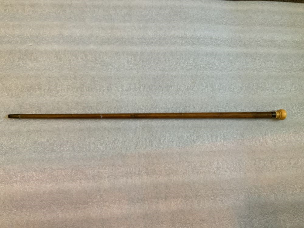
- Title
- Cane
- Date
- 1887 – 1887
- Material
- wood; metal, silver
- Dimensions
- 85.0 cm
- Description
- A straight walking stick with a textured silver handle that is bent at a right angle to the stick. An inscription on the handle reads: “H.F.M. to J.W.B. April 18, ‘87”. The handle is also marked “sterling”.
- Subject
- assistive device
- social customs
- Credit
- Gift of Pearl Evelyn Moore, Banff, 1979
- Catalogue Number
- 103.08.0107
Images

This material is presented as originally created; it may contain outdated cultural descriptions and
potentially offensive content.
Read more.
- Date
- 1759 – 1759
- Material
- wood; ivory; metal, brass; metal, silver
- Catalogue Number
- 103.08.0110
- Description
- A straight walking stick with an ivory knob handle joined to the wooden stick with a silver ring. The bottom tip of the cane is covered with brass. There are holes at either side of the top of the cane for a hand strap. The silver ring is inscribed with “Fort Dummer 1759 James W. Brown”.
1 image
- Title
- Cane
- Date
- 1759 – 1759
- Material
- wood; ivory; metal, brass; metal, silver
- Dimensions
- 81.0 cm
- Description
- A straight walking stick with an ivory knob handle joined to the wooden stick with a silver ring. The bottom tip of the cane is covered with brass. There are holes at either side of the top of the cane for a hand strap. The silver ring is inscribed with “Fort Dummer 1759 James W. Brown”.
- Credit
- Gift of Pearl Evelyn Moore, Banff, 1979
- Catalogue Number
- 103.08.0110
Images
This material is presented as originally created; it may contain outdated cultural descriptions and
potentially offensive content.
Read more.
(Castle Mountain Area)
https://archives.whyte.org/en/permalink/catalogue24481
- Medium
- Library - Maps and blueprints (unannotated; published)
- Map
- Published Date
- April 14, 1888
- Publisher
- Dominion Lands Office
- Call Number
- C9-7.27
- Publisher
- Dominion Lands Office
- Published Date
- April 14, 1888
- Physical Description
- 1 map : black and white
- Scale
- 40 chains: 1 inch
- Notes
- xerox copy
- Accession Number
- SG7500
- Call Number
- C9-7.27
- Collection
- Archives Library
This material is presented as originally created; it may contain outdated cultural descriptions and
potentially offensive content.
Read more.
Copy of Map of "Colton's North America"
https://archives.whyte.org/en/permalink/catalogue21525
- Medium
- Library - Maps and blueprints (unannotated; published)
- Map
- Published Date
- 1882
- Publisher
- G.W. and C.B. Colton and Co.
- Call Number
- C13-4.4
- Publisher
- G.W. and C.B. Colton and Co.
- Published Date
- 1882
- Subjects
- North America
- Accession Number
- 11,500
- Call Number
- C13-4.4
- Collection
- Archives Library
This material is presented as originally created; it may contain outdated cultural descriptions and
potentially offensive content.
Read more.
Electoral Districts for the Legislative Assembly and the Railroad System
https://archives.whyte.org/en/permalink/catalogue21500
- Medium
- Library - Maps and blueprints (unannotated; published)
- Map
- Published Date
- 1888
- Call Number
- C12-1.26
- Published Date
- 1888
- Subjects
- North West Territory
- Notes
- Photostatic copy from Public Archives
- Accession Number
- 675
- Call Number
- C12-1.26
- Collection
- Archives Library
This material is presented as originally created; it may contain outdated cultural descriptions and
potentially offensive content.
Read more.
Map of the Kootenay region to accompany report of Supt. S.B. Steele comanding the detachment of Mounted Police in B.C.
https://archives.whyte.org/en/permalink/catalogue21416
- Medium
- Library - Maps and blueprints (unannotated; published)
- Map
- Published Date
- 1888
- Call Number
- C10-6.2
- Published Date
- 1888
- Subjects
- Central British Columbia
- Notes
- Photostatic copy from Public Archives
- Accession Number
- 675
- Call Number
- C10-6.2
- Collection
- Archives Library
This material is presented as originally created; it may contain outdated cultural descriptions and
potentially offensive content.
Read more.
Map shewing the Distribution of the Indian Tribes of British Columbia by W.F. Tolmie and G.M. Dawson
https://archives.whyte.org/en/permalink/catalogue21365
- Medium
- Library - Maps and blueprints (unannotated; published)
- Map
- Published Date
- 1883
- Publisher
- Geological and Natural History Survey of Canada
- Call Number
- C6-10.2(a)
- Responsibility
- W.F. Tolmie and G.M. Dawson
- Publisher
- Geological and Natural History Survey of Canada
- Published Date
- 1883
- Subjects
- Indian Tribes of British Columbia
- Notes
- Accompanies "Comparative Vocabularies of the Indian Tribes of B.C."
- Accession Number
- 400
- Call Number
- C6-10.2(a)
- Collection
- Archives Library
This material is presented as originally created; it may contain outdated cultural descriptions and
potentially offensive content.
Read more.