Narrow Results By
[British North America]
https://archives.whyte.org/en/permalink/catalogue21421
- Medium
- Library - Maps and blueprints (unannotated; published)
- Map
- Published Date
- 1754-1761
- Publisher
- Canadian Geographic Journal (Public Archives of Canada)
- Call Number
- C11-1.2
- Publisher
- Canadian Geographic Journal (Public Archives of Canada)
- Published Date
- 1754-1761
- Subjects
- British North America
- Accession Number
- 495
- Call Number
- C11-1.2
- Collection
- Archives Library
This material is presented as originally created; it may contain outdated cultural descriptions and
potentially offensive content.
Read more.
Canadian Irrigation Surveys; A preliminary map of a portion of the foothills region from photographic and micrometer surveys by Division B; A.O. Wheeler in charge.
https://archives.whyte.org/en/permalink/catalogue23360
- Medium
- Library - Maps and blueprints (unannotated; published)
- Map
- Published Date
- 1895-6
- Publisher
- Department of the Interior
- Call Number
- C5-6.26(c)
- Publisher
- Department of the Interior
- Published Date
- 1895-6
- Physical Description
- Black and white
- Scale
- 1 1/4 miles - 1"
- Subjects
- Alberta-Irrigation
- Notes
- xerox copy
- Accession Number
- 6000
- Call Number
- C5-6.26(c)
- Collection
- Archives Library
This material is presented as originally created; it may contain outdated cultural descriptions and
potentially offensive content.
Read more.
- Date
- 1759 – 1759
- Material
- wood; ivory; metal, brass; metal, silver
- Catalogue Number
- 103.08.0110
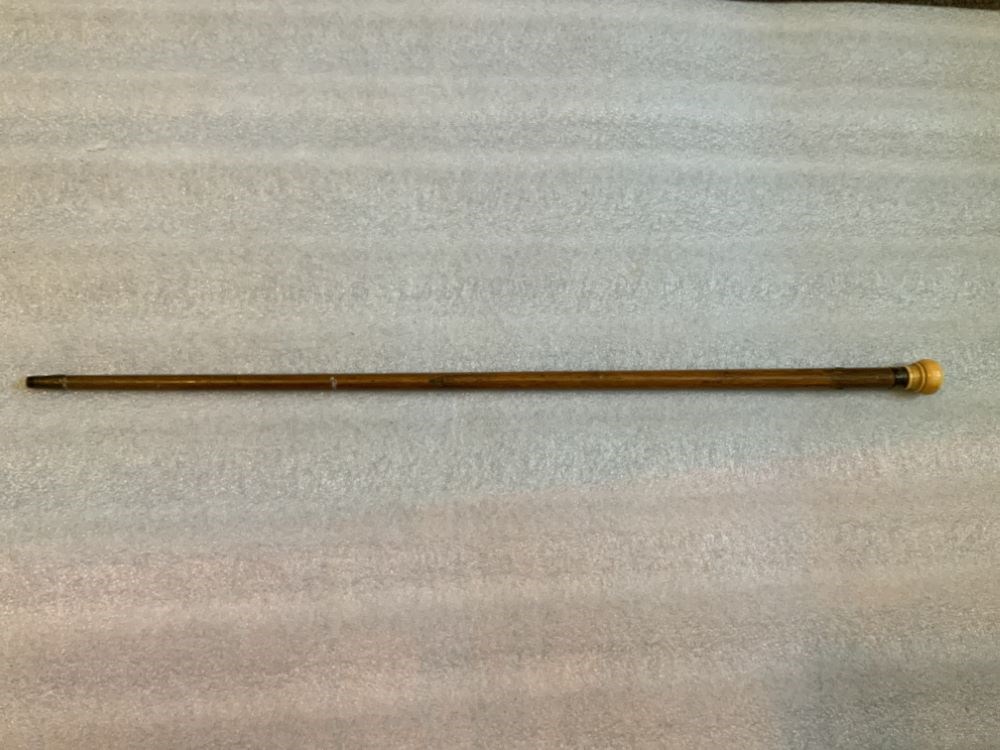
- Description
- A straight walking stick with an ivory knob handle joined to the wooden stick with a silver ring. The bottom tip of the cane is covered with brass. There are holes at either side of the top of the cane for a hand strap. The silver ring is inscribed with “Fort Dummer 1759 James W. Brown”.
1 image
- Title
- Cane
- Date
- 1759 – 1759
- Material
- wood; ivory; metal, brass; metal, silver
- Dimensions
- 81.0 cm
- Description
- A straight walking stick with an ivory knob handle joined to the wooden stick with a silver ring. The bottom tip of the cane is covered with brass. There are holes at either side of the top of the cane for a hand strap. The silver ring is inscribed with “Fort Dummer 1759 James W. Brown”.
- Credit
- Gift of Pearl Evelyn Moore, Banff, 1979
- Catalogue Number
- 103.08.0110
Images
This material is presented as originally created; it may contain outdated cultural descriptions and
potentially offensive content.
Read more.
Cart trail from Calgary to Edmonton
https://archives.whyte.org/en/permalink/catalogue24486
- Medium
- Library - Maps and blueprints (unannotated; published)
- Map
- Published Date
- 1890
- Publisher
- Dept. of the Interior
- Call Number
- C9-7.31
- Publisher
- Dept. of the Interior
- Published Date
- 1890
- Scale
- 1 mile: 2 inches
- Notes
- photostatic copy from Public Archives
- Accession Number
- 675
- Call Number
- C9-7.31
- Collection
- Archives Library
This material is presented as originally created; it may contain outdated cultural descriptions and
potentially offensive content.
Read more.
(Castle Mtn. area)
https://archives.whyte.org/en/permalink/catalogue24472
- Medium
- Library - Maps and blueprints (unannotated; published)
- Map
- Published Date
- April 26th, 1890
- Publisher
- Dominion Lands Office
- Call Number
- C9-7.25
- Publisher
- Dominion Lands Office
- Published Date
- April 26th, 1890
- Physical Description
- 1 map : col
- Scale
- 40 chains: 1 "
- Accession Number
- SG7500
- Call Number
- C9-7.25
- Collection
- Archives Library
This material is presented as originally created; it may contain outdated cultural descriptions and
potentially offensive content.
Read more.
Dominion of Canada and Newfoundland
https://archives.whyte.org/en/permalink/catalogue24550
- Medium
- Library - Maps and blueprints (unannotated; published)
- Map
- Published Date
- 1898
- Publisher
- Rand McNally and Co. Republished by the Royal Canadian Geographical Society in 1967 in recognition of Canada's Centennial
- Call Number
- C11-2.3
- Publisher
- Rand McNally and Co. Republished by the Royal Canadian Geographical Society in 1967 in recognition of Canada's Centennial
- Published Date
- 1898
- Scale
- Scale: 180 miles - 1 inch
- Subjects
- Canada
- Notes
- Duplicate in map room/Accn: 400)
- Accession Number
- 400
- 673
- Call Number
- C11-2.3
- Collection
- Archives Library
This material is presented as originally created; it may contain outdated cultural descriptions and
potentially offensive content.
Read more.
(edge of Lake Louise Forest Park)
https://archives.whyte.org/en/permalink/catalogue24485
- Medium
- Library - Maps and blueprints (unannotated; published)
- Map
- Published Date
- January 7th, 1896
- Publisher
- Department of the Interior
- Call Number
- C9-7.29
- Publisher
- Department of the Interior
- Published Date
- January 7th, 1896
- Physical Description
- 1 map : black and white
- Scale
- 40 chains: 1 inch
- Notes
- xerox copy
- Accession Number
- SG7500
- Call Number
- C9-7.29
- Collection
- Archives Library
This material is presented as originally created; it may contain outdated cultural descriptions and
potentially offensive content.
Read more.
- Medium
- Library - Maps and blueprints (unannotated; published)
- Map
- Published Date
- 1898
- Call Number
- C12-1.13
- Published Date
- 1898
- Scale
- 50 miles to 1 inch
- Subjects
- Northwestern Canada
- Notes
- four sections
- Photostatic copy from Public Archives
- Accession Number
- 675
- Call Number
- C12-1.13
- Collection
- Archives Library
This material is presented as originally created; it may contain outdated cultural descriptions and
potentially offensive content.
Read more.
(Lake Louise Forest Park)
https://archives.whyte.org/en/permalink/catalogue24484
- Medium
- Library - Maps and blueprints (unannotated; published)
- Map
- Published Date
- February 10, 1896
- Publisher
- Department of the Interior
- Call Number
- C9-7.28
- Publisher
- Department of the Interior
- Published Date
- February 10, 1896
- Physical Description
- 1 map : black and white
- Scale
- 40 chains: 1 inch
- Notes
- xerox copy
- Accession Number
- SG7500
- Call Number
- C9-7.28
- Collection
- Archives Library
This material is presented as originally created; it may contain outdated cultural descriptions and
potentially offensive content.
Read more.
Map of the Kootenay District - A mining recording divisions map
https://archives.whyte.org/en/permalink/catalogue24533
- Medium
- Library - Maps and blueprints (unannotated; published)
- Map
- Published Date
- 1897
- Publisher
- Dept. of Lands and Works, Victoria
- Call Number
- C10-6.3
- Publisher
- Dept. of Lands and Works, Victoria
- Published Date
- 1897
- Scale
- Scale: 12 miles - 1 inch
- Subjects
- Central British Columbia
- Notes
- Photostatic copy from Public Archives
- Accession Number
- 675
- Call Number
- C10-6.3
- Collection
- Archives Library
This material is presented as originally created; it may contain outdated cultural descriptions and
potentially offensive content.
Read more.