Narrow Results By
Area of the Upper Missouri and Rocky Mts.
https://archives.whyte.org/en/permalink/catalogue21495
- Medium
- Library - Maps and blueprints (unannotated; published)
- Map
- Published Date
- 1801
- Call Number
- C12-1.20
- Published Date
- 1801
- Subjects
- Indian Map
- Notes
- Photostatic copy from Public Archives
- two sections
- Accession Number
- 675
- Call Number
- C12-1.20
- Collection
- Archives Library
This material is presented as originally created; it may contain outdated cultural descriptions and
potentially offensive content.
Read more.
Chart of Lakes and Rivers
https://archives.whyte.org/en/permalink/catalogue21491
- Medium
- Library - Maps and blueprints (unannotated; published)
- Map
- Published Date
- c. 1780
- Call Number
- C12-1.16
- Published Date
- c. 1780
- Subjects
- North America
- Notes
- Photostatic copy from Public Archives
- two sections
- Accession Number
- 675
- Call Number
- C12-1.16
- Collection
- Archives Library
This material is presented as originally created; it may contain outdated cultural descriptions and
potentially offensive content.
Read more.
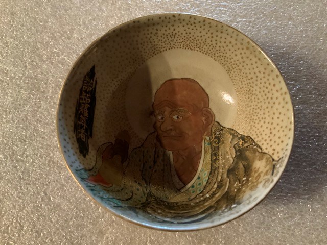
Decorative Bowl
https://archives.whyte.org/en/permalink/artifact102.04.0260
- Date
- 1800 – 1890
- Material
- ceramic
- Catalogue Number
- 102.04.0260
- Description
- Hand-thrown, trimmed footed small bowl with elaborate floral enamel and gold lustre design on exterior. Interior bowl has portrait of man (wearing earring) holding ball surrounded by halo of gold lustre polka dots. Calligraphy inside bowl.
1 image
- Title
- Decorative Bowl
- Date
- 1800 – 1890
- Material
- ceramic
- Dimensions
- 3.4 x 7.6 cm
- Description
- Hand-thrown, trimmed footed small bowl with elaborate floral enamel and gold lustre design on exterior. Interior bowl has portrait of man (wearing earring) holding ball surrounded by halo of gold lustre polka dots. Calligraphy inside bowl.
- Subject
- households
- decorative
- miniatures
- E. S. Morse
- Credit
- Gift of Catharine Robb Whyte, O. C., Banff, 1979
- Catalogue Number
- 102.04.0260
Images
This material is presented as originally created; it may contain outdated cultural descriptions and
potentially offensive content.
Read more.
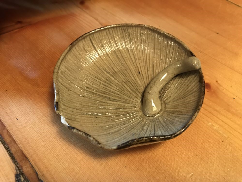
Decorative Bowl
https://archives.whyte.org/en/permalink/artifact102.04.0261
- Date
- 1800 – 1890
- Material
- ceramic
- Catalogue Number
- 102.04.0261
- Description
- Mushroom shaped bowl showing (underside) gills and curved stem. Outside bowl represents cap of mushroom. Interior glaze grey/beige. Exterior (cap) glaze mottled beige, brown, yellow. Was previously broken and repaired with lustre close to stem. Two other pieces along rim have been repaired and ther…
1 image
- Title
- Decorative Bowl
- Date
- 1800 – 1890
- Material
- ceramic
- Dimensions
- 2.8 x 9.1 cm
- Description
- Mushroom shaped bowl showing (underside) gills and curved stem. Outside bowl represents cap of mushroom. Interior glaze grey/beige. Exterior (cap) glaze mottled beige, brown, yellow. Was previously broken and repaired with lustre close to stem. Two other pieces along rim have been repaired and there is still a .8 x .5 cm. chip missing from same area.
- Subject
- households
- decorative
- E. S. Morse
- Credit
- Gift of Catharine Robb Whyte, O. C., Banff, 1979
- Catalogue Number
- 102.04.0261
Images
This material is presented as originally created; it may contain outdated cultural descriptions and
potentially offensive content.
Read more.
Map from Tyrell Papers
https://archives.whyte.org/en/permalink/catalogue21558
- Medium
- Library - Maps and blueprints (unannotated; published)
- Map
- Published Date
- 1785
- Call Number
- C12-1.1
- Published Date
- 1785
- Subjects
- Western Canada
- Notes
- Photostatic copy from Public Archives
- Accession Number
- 675
- Call Number
- C12-1.1
- Collection
- Archives Library
This material is presented as originally created; it may contain outdated cultural descriptions and
potentially offensive content.
Read more.
A map of America ... exhibiting Mackenzie's track from Montreal to Fort Chipewyan and from thence to the North Sea in 1789 & to the West Pacific Ocean in 1793
https://archives.whyte.org/en/permalink/catalogue24546
- Medium
- Library - Maps and blueprints (unannotated; published)
- Map
- Published Date
- 1801
- Publisher
- London : A.M.
- Call Number
- C11-1.8
- Publisher
- London : A.M.
- Published Date
- 1801
- Physical Description
- 1 map
- Scale
- Scale indeterminable
- Subjects
- Mackenzie, Alexander
- Accession Number
- 5241
- Call Number
- C11-1.8
- Collection
- Archives Library
This material is presented as originally created; it may contain outdated cultural descriptions and
potentially offensive content.
Read more.
Map of his discoveries presented to Congress by Peter Pond
https://archives.whyte.org/en/permalink/catalogue21479
- Medium
- Library - Maps and blueprints (unannotated; published)
- Map
- Published Date
- 1785
- Author
- Pond, Peter
- Call Number
- C12-1.6
- Author
- Pond, Peter
- Published Date
- 1785
- Subjects
- Peter Pond
- Notes
- Photostatic copy from Public Archives
- Accession Number
- 675
- Call Number
- C12-1.6
- Collection
- Archives Library
This material is presented as originally created; it may contain outdated cultural descriptions and
potentially offensive content.
Read more.
Map of his discoveries presented to Congress by Peter Pond
https://archives.whyte.org/en/permalink/catalogue21480
- Medium
- Library - Maps and blueprints (unannotated; published)
- Map
- Published Date
- 1785
- Author
- Pond, Peter
- Call Number
- C12-1.6(a)
- Author
- Pond, Peter
- Published Date
- 1785
- Subjects
- Peter Pond
- Notes
- Accompanies 02.5/P77w
- Accession Number
- 400
- Call Number
- C12-1.6(a)
- Collection
- Archives Library
This material is presented as originally created; it may contain outdated cultural descriptions and
potentially offensive content.
Read more.
Map of North America
https://archives.whyte.org/en/permalink/catalogue21481
- Medium
- Library - Maps and blueprints (unannotated; published)
- Map
- Published Date
- 1785
- Author
- Pond, Peter
- Call Number
- C12-1.7
- Author
- Pond, Peter
- Published Date
- 1785
- Subjects
- Peter Pond's Map
- Notes
- Photostatic copy from Public Archives
- Accession Number
- 675
- Call Number
- C12-1.7
- Collection
- Archives Library
This material is presented as originally created; it may contain outdated cultural descriptions and
potentially offensive content.
Read more.
Map of North America
https://archives.whyte.org/en/permalink/catalogue21482
- Medium
- Library - Maps and blueprints (unannotated; published)
- Map
- Published Date
- 1785
- Author
- Pond, Peter
- Call Number
- C12-1.7(a)
- Author
- Pond, Peter
- Published Date
- 1785
- Subjects
- Peter Pond's Map
- Notes
- Photostatic copy from Public Archives
- Accession Number
- 400
- Call Number
- C12-1.7(a)
- Collection
- Archives Library
This material is presented as originally created; it may contain outdated cultural descriptions and
potentially offensive content.
Read more.
A map showing the communication of the lakes and rivers between Lake Superior and Slave Lake in North America
https://archives.whyte.org/en/permalink/catalogue24545
- Medium
- Library - Maps and blueprints (unannotated; published)
- Map
- Published Date
- 1790
- Publisher
- Gent. Mag.
- Call Number
- C11-1.7
- Publisher
- Gent. Mag.
- Published Date
- 1790
- Physical Description
- 1 map
- Scale
- Scale indeterminable
- Subjects
- Rivers
- The West, Canadian
- Accession Number
- 12,500
- Call Number
- C11-1.7
- Collection
- Archives Library
This material is presented as originally created; it may contain outdated cultural descriptions and
potentially offensive content.
Read more.
Map showing the communication of the Lakes and Rivers between Lake Superior and Slave Lake in North America
https://archives.whyte.org/en/permalink/catalogue21338
- Medium
- Library - Maps and blueprints (unannotated; published)
- Map
- Published Date
- 1790
- Publisher
- Gent Mag.
- Call Number
- C5-5.8
- Publisher
- Gent Mag.
- Published Date
- 1790
- Subjects
- Hydrological Maps Canada
- Notes
- From a copy - Gent Mag. 1790
- Accession Number
- 11,500
- Call Number
- C5-5.8
- Collection
- Archives Library
This material is presented as originally created; it may contain outdated cultural descriptions and
potentially offensive content.
Read more.
Mercator's Projection showing new discoveries
https://archives.whyte.org/en/permalink/catalogue21531
- Medium
- Library - Maps and blueprints (unannotated; published)
- Map
- Published Date
- 1789
- Call Number
- C13-11.1
- Published Date
- 1789
- Subjects
- World
- Notes
- Photostatic copy from Public Archives
- C13-11.1(a), (b), (c), (d)
- Accession Number
- 675
- Call Number
- C13-11.1
- Collection
- Archives Library
This material is presented as originally created; it may contain outdated cultural descriptions and
potentially offensive content.
Read more.
New discoveries in the Interior
https://archives.whyte.org/en/permalink/catalogue21493
- Medium
- Library - Maps and blueprints (unannotated; published)
- Map
- Published Date
- 1802
- Call Number
- C12-1.18
- Published Date
- 1802
- Subjects
- North America
- Notes
- four sections
- Photostatic copy from Public Archives
- Accession Number
- 675
- Call Number
- C12-1.18
- Collection
- Archives Library
This material is presented as originally created; it may contain outdated cultural descriptions and
potentially offensive content.
Read more.
North West Territories
https://archives.whyte.org/en/permalink/catalogue21483
- Medium
- Library - Maps and blueprints (unannotated; published)
- Map
- Published Date
- 1787
- Author
- Pond, Peter
- Call Number
- C12-1.8
- Author
- Pond, Peter
- Published Date
- 1787
- Subjects
- Peter Pond's Map
- Notes
- Photostatic copy from Public Archives
- three sections
- Accession Number
- 675
- Call Number
- C12-1.8
- Collection
- Archives Library
This material is presented as originally created; it may contain outdated cultural descriptions and
potentially offensive content.
Read more.
North West Territories
https://archives.whyte.org/en/permalink/catalogue21484
- Medium
- Library - Maps and blueprints (unannotated; published)
- Map
- Published Date
- 1787
- Author
- Pond, Peter
- Call Number
- C12-1.8(d)
- Author
- Pond, Peter
- Published Date
- 1787
- Subjects
- Peter Pond's Map
- Notes
- Accompanies 02.5/P77w
- Smaller scale of maps: C12-1.8 (a) (b) (c)
- Accession Number
- 400
- Call Number
- C12-1.8(d)
- Collection
- Archives Library
This material is presented as originally created; it may contain outdated cultural descriptions and
potentially offensive content.
Read more.
"Skeleton plan showing location of 'Kootenae House' built by David Thompson, 1807"
https://archives.whyte.org/en/permalink/catalogue23292
- Medium
- Library - Maps and blueprints (unannotated; published)
- Map
- Published Date
- 1807
- Publisher
- J.B. Tyrrell papers
- Call Number
- C4-5.3
- Responsibility
- Basil G. Hamilton, Invermere, B.C.
- Publisher
- J.B. Tyrrell papers
- Published Date
- 1807
- Scale
- 606' - 1"
- Subjects
- Kootenae
- Notes
- Photostatistic copy from Public Archives From J.B. Tyrrell papers, transfered from the manuscript division Nov. 6, 1962
- Accession Number
- 675
- Call Number
- C4-5.3
- Collection
- Archives Library
This material is presented as originally created; it may contain outdated cultural descriptions and
potentially offensive content.
Read more.
Travels through Western Canada from April, 1773 to March, 1790
https://archives.whyte.org/en/permalink/catalogue21485
- Medium
- Library - Maps and blueprints (unannotated; published)
- Map
- Published Date
- 1790
- Call Number
- C12-1.9
- Published Date
- 1790
- Subjects
- Peter Pond's Travels
- Notes
- Photostatic copy from Public Archives
- Accession Number
- 675
- Call Number
- C12-1.9
- Collection
- Archives Library
This material is presented as originally created; it may contain outdated cultural descriptions and
potentially offensive content.
Read more.