Narrow Results By
Area of the Upper Missouri and Rocky Mts.
https://archives.whyte.org/en/permalink/catalogue21495
- Medium
- Library - Maps and blueprints (unannotated; published)
- Map
- Published Date
- 1801
- Call Number
- C12-1.20
- Published Date
- 1801
- Subjects
- Indian Map
- Notes
- Photostatic copy from Public Archives
- two sections
- Accession Number
- 675
- Call Number
- C12-1.20
- Collection
- Archives Library
This material is presented as originally created; it may contain outdated cultural descriptions and
potentially offensive content.
Read more.
Chart of Lakes and Rivers
https://archives.whyte.org/en/permalink/catalogue21491
- Medium
- Library - Maps and blueprints (unannotated; published)
- Map
- Published Date
- c. 1780
- Call Number
- C12-1.16
- Published Date
- c. 1780
- Subjects
- North America
- Notes
- Photostatic copy from Public Archives
- two sections
- Accession Number
- 675
- Call Number
- C12-1.16
- Collection
- Archives Library
This material is presented as originally created; it may contain outdated cultural descriptions and
potentially offensive content.
Read more.
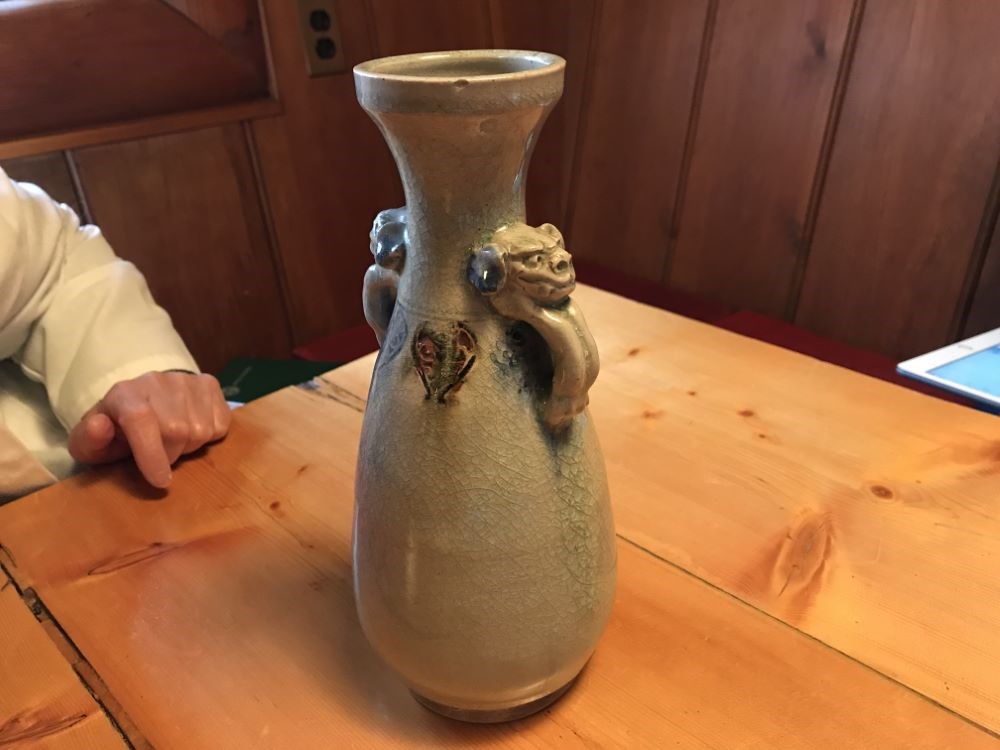
Decorative Vase
https://archives.whyte.org/en/permalink/artifact102.04.0258
- Date
- 1800 – 1890
- Material
- ceramic
- Catalogue Number
- 102.04.0258
- Description
- Hand-thrown, trimmed footed, amphora shaped container with two affixed, animal head handles where bottle narrows then flares out to tooled, flat rim. Blue/green/rush decoration at neck and very pale, transparent green over-glaze.
1 image
- Title
- Decorative Vase
- Date
- 1800 – 1890
- Material
- ceramic
- Dimensions
- 24.3 x 10.4 cm
- Description
- Hand-thrown, trimmed footed, amphora shaped container with two affixed, animal head handles where bottle narrows then flares out to tooled, flat rim. Blue/green/rush decoration at neck and very pale, transparent green over-glaze.
- Subject
- households
- decorative
- E. S. Morse
- Credit
- Gift of Catharine Robb Whyte, O. C., Banff, 1979
- Catalogue Number
- 102.04.0258
Images
This material is presented as originally created; it may contain outdated cultural descriptions and
potentially offensive content.
Read more.
Decorative Vase
https://archives.whyte.org/en/permalink/artifact102.04.0262
- Date
- 1800 – 1890
- Material
- ceramic
- Catalogue Number
- 102.04.0262
- Description
- Hard-thrown, trimmed footed, urn-shaped vase with indent at shoulder with flared neck and rim. Transparent glaze with two decorative panels surrounded by deep orange and gold enamel decorations. One panel floral, other two men aside tree. Various orange and gold border trims. Calligraphy on base.
1 image
- Title
- Decorative Vase
- Date
- 1800 – 1890
- Material
- ceramic
- Dimensions
- 16.1 x 6.4 cm
- Description
- Hard-thrown, trimmed footed, urn-shaped vase with indent at shoulder with flared neck and rim. Transparent glaze with two decorative panels surrounded by deep orange and gold enamel decorations. One panel floral, other two men aside tree. Various orange and gold border trims. Calligraphy on base.
- Subject
- households
- decorative
- E. S. Morse
- Credit
- Gift of Catharine Robb Whyte, O. C., Banff, 1979
- Catalogue Number
- 102.04.0262
Images

This material is presented as originally created; it may contain outdated cultural descriptions and
potentially offensive content.
Read more.
Map from Tyrell Papers
https://archives.whyte.org/en/permalink/catalogue21558
- Medium
- Library - Maps and blueprints (unannotated; published)
- Map
- Published Date
- 1785
- Call Number
- C12-1.1
- Published Date
- 1785
- Subjects
- Western Canada
- Notes
- Photostatic copy from Public Archives
- Accession Number
- 675
- Call Number
- C12-1.1
- Collection
- Archives Library
This material is presented as originally created; it may contain outdated cultural descriptions and
potentially offensive content.
Read more.
A map of America ... exhibiting Mackenzie's track from Montreal to Fort Chipewyan and from thence to the North Sea in 1789 & to the West Pacific Ocean in 1793
https://archives.whyte.org/en/permalink/catalogue24546
- Medium
- Library - Maps and blueprints (unannotated; published)
- Map
- Published Date
- 1801
- Publisher
- London : A.M.
- Call Number
- C11-1.8
- Publisher
- London : A.M.
- Published Date
- 1801
- Physical Description
- 1 map
- Scale
- Scale indeterminable
- Subjects
- Mackenzie, Alexander
- Accession Number
- 5241
- Call Number
- C11-1.8
- Collection
- Archives Library
This material is presented as originally created; it may contain outdated cultural descriptions and
potentially offensive content.
Read more.
Map of his discoveries presented to Congress by Peter Pond
https://archives.whyte.org/en/permalink/catalogue21479
- Medium
- Library - Maps and blueprints (unannotated; published)
- Map
- Published Date
- 1785
- Author
- Pond, Peter
- Call Number
- C12-1.6
- Author
- Pond, Peter
- Published Date
- 1785
- Subjects
- Peter Pond
- Notes
- Photostatic copy from Public Archives
- Accession Number
- 675
- Call Number
- C12-1.6
- Collection
- Archives Library
This material is presented as originally created; it may contain outdated cultural descriptions and
potentially offensive content.
Read more.
Map of his discoveries presented to Congress by Peter Pond
https://archives.whyte.org/en/permalink/catalogue21480
- Medium
- Library - Maps and blueprints (unannotated; published)
- Map
- Published Date
- 1785
- Author
- Pond, Peter
- Call Number
- C12-1.6(a)
- Author
- Pond, Peter
- Published Date
- 1785
- Subjects
- Peter Pond
- Notes
- Accompanies 02.5/P77w
- Accession Number
- 400
- Call Number
- C12-1.6(a)
- Collection
- Archives Library
This material is presented as originally created; it may contain outdated cultural descriptions and
potentially offensive content.
Read more.
Map of North America
https://archives.whyte.org/en/permalink/catalogue21481
- Medium
- Library - Maps and blueprints (unannotated; published)
- Map
- Published Date
- 1785
- Author
- Pond, Peter
- Call Number
- C12-1.7
- Author
- Pond, Peter
- Published Date
- 1785
- Subjects
- Peter Pond's Map
- Notes
- Photostatic copy from Public Archives
- Accession Number
- 675
- Call Number
- C12-1.7
- Collection
- Archives Library
This material is presented as originally created; it may contain outdated cultural descriptions and
potentially offensive content.
Read more.
Map of North America
https://archives.whyte.org/en/permalink/catalogue21482
- Medium
- Library - Maps and blueprints (unannotated; published)
- Map
- Published Date
- 1785
- Author
- Pond, Peter
- Call Number
- C12-1.7(a)
- Author
- Pond, Peter
- Published Date
- 1785
- Subjects
- Peter Pond's Map
- Notes
- Photostatic copy from Public Archives
- Accession Number
- 400
- Call Number
- C12-1.7(a)
- Collection
- Archives Library
This material is presented as originally created; it may contain outdated cultural descriptions and
potentially offensive content.
Read more.
Mercator's Projection showing new discoveries
https://archives.whyte.org/en/permalink/catalogue21531
- Medium
- Library - Maps and blueprints (unannotated; published)
- Map
- Published Date
- 1789
- Call Number
- C13-11.1
- Published Date
- 1789
- Subjects
- World
- Notes
- Photostatic copy from Public Archives
- C13-11.1(a), (b), (c), (d)
- Accession Number
- 675
- Call Number
- C13-11.1
- Collection
- Archives Library
This material is presented as originally created; it may contain outdated cultural descriptions and
potentially offensive content.
Read more.
New discoveries in the Interior
https://archives.whyte.org/en/permalink/catalogue21493
- Medium
- Library - Maps and blueprints (unannotated; published)
- Map
- Published Date
- 1802
- Call Number
- C12-1.18
- Published Date
- 1802
- Subjects
- North America
- Notes
- four sections
- Photostatic copy from Public Archives
- Accession Number
- 675
- Call Number
- C12-1.18
- Collection
- Archives Library
This material is presented as originally created; it may contain outdated cultural descriptions and
potentially offensive content.
Read more.
North West Territories
https://archives.whyte.org/en/permalink/catalogue21483
- Medium
- Library - Maps and blueprints (unannotated; published)
- Map
- Published Date
- 1787
- Author
- Pond, Peter
- Call Number
- C12-1.8
- Author
- Pond, Peter
- Published Date
- 1787
- Subjects
- Peter Pond's Map
- Notes
- Photostatic copy from Public Archives
- three sections
- Accession Number
- 675
- Call Number
- C12-1.8
- Collection
- Archives Library
This material is presented as originally created; it may contain outdated cultural descriptions and
potentially offensive content.
Read more.
North West Territories
https://archives.whyte.org/en/permalink/catalogue21484
- Medium
- Library - Maps and blueprints (unannotated; published)
- Map
- Published Date
- 1787
- Author
- Pond, Peter
- Call Number
- C12-1.8(d)
- Author
- Pond, Peter
- Published Date
- 1787
- Subjects
- Peter Pond's Map
- Notes
- Accompanies 02.5/P77w
- Smaller scale of maps: C12-1.8 (a) (b) (c)
- Accession Number
- 400
- Call Number
- C12-1.8(d)
- Collection
- Archives Library
This material is presented as originally created; it may contain outdated cultural descriptions and
potentially offensive content.
Read more.
"Skeleton plan showing location of 'Kootenae House' built by David Thompson, 1807"
https://archives.whyte.org/en/permalink/catalogue23292
- Medium
- Library - Maps and blueprints (unannotated; published)
- Map
- Published Date
- 1807
- Publisher
- J.B. Tyrrell papers
- Call Number
- C4-5.3
- Responsibility
- Basil G. Hamilton, Invermere, B.C.
- Publisher
- J.B. Tyrrell papers
- Published Date
- 1807
- Scale
- 606' - 1"
- Subjects
- Kootenae
- Notes
- Photostatistic copy from Public Archives From J.B. Tyrrell papers, transfered from the manuscript division Nov. 6, 1962
- Accession Number
- 675
- Call Number
- C4-5.3
- Collection
- Archives Library
This material is presented as originally created; it may contain outdated cultural descriptions and
potentially offensive content.
Read more.