Narrow Results By
- Peter Whyte (1905 – 1966, Canadian) 40
- Catharine Robb Whyte, O. C. (1906 – 1979, Canadian) 7
- John Lefthand Jr. 6
- Tom Lonsdale (1886 – 1975, Canadian) 5
- Cornelius David Krieghoff (1815 – 1872, Canadian) 2
- Earl F. Spencer 2
- Elizabeth Rummel (1897 – 1980, Canadian) 2
- Henry George Glyde (1906 – 1998, Canadian) 2
- Edward Fred Hagell (1895 – 1964, Canadian) 1
- Ella May Walker (1892 – 1960, Canadian) 1
- Ernest C. W Lamarque (1879 – 1970, Canadian) 1
- George Browne (1918 – 1958, American) 1
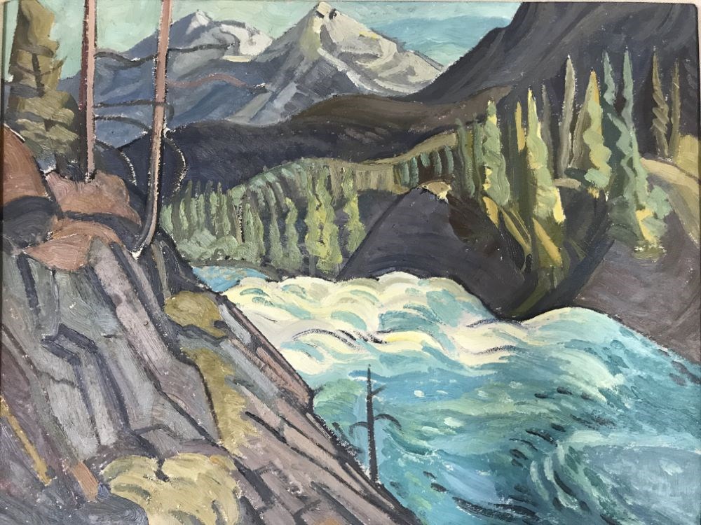
Above Bow Falls
https://archives.whyte.org/en/permalink/artifactgyh.02.15
- Date
- 1952
- Medium
- oil on board
- Catalogue Number
- GyH.02.15
- Description
- A low and wide, white and blue waterfall between gray rocks with evergreen trees mountains in the background.
1 image
- Title
- Above Bow Falls
- Date
- 1952
- Medium
- oil on board
- Dimensions
- 31.0 x 39.0 cm
- Description
- A low and wide, white and blue waterfall between gray rocks with evergreen trees mountains in the background.
- Subject
- Banff
- Bow Falls
- Rocky Mountains
- water
- waterfall
- Credit
- Gift of Fred Burghardt, Edmonton, 2018
- Catalogue Number
- GyH.02.15
Images
This material is presented as originally created; it may contain outdated cultural descriptions and
potentially offensive content.
Read more.
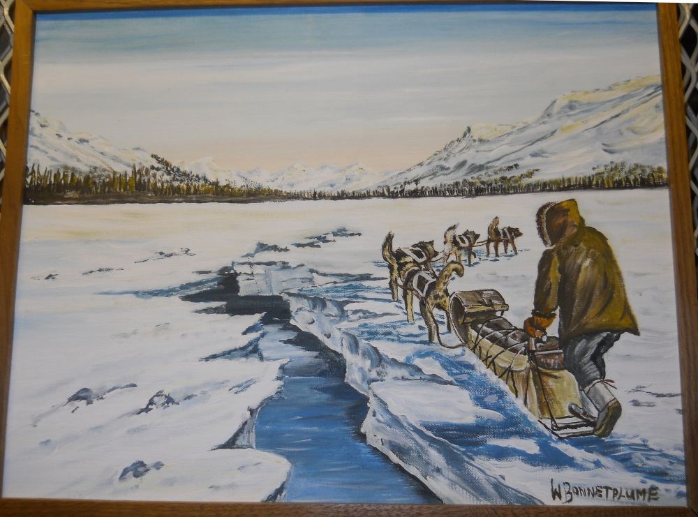
Aklavik, N.W.T.
https://archives.whyte.org/en/permalink/artifactbpw.02.02
- Date
- prior to 1977
- Medium
- oil on canvas board
- Catalogue Number
- BpW.02.02
- Description
- General colour: blue with green, yellow, brown. A figure, sled and team of four dogs fills lower right quarter of picture. A broad crack in the frozen lake runs up from the center at the bottom and disappears into the horizon of trees. The far shore and mountains beyond start two thirds up the pict…
1 image
- Title
- Aklavik, N.W.T.
- Date
- prior to 1977
- Medium
- oil on canvas board
- Dimensions
- 35.6 x 45.6 cm
- Description
- General colour: blue with green, yellow, brown. A figure, sled and team of four dogs fills lower right quarter of picture. A broad crack in the frozen lake runs up from the center at the bottom and disappears into the horizon of trees. The far shore and mountains beyond start two thirds up the picture.
- Credit
- Purchased from William Bonnetplume, 1978
- Catalogue Number
- BpW.02.02
Images
This material is presented as originally created; it may contain outdated cultural descriptions and
potentially offensive content.
Read more.
Alberta and British Columbia [road map]
https://archives.whyte.org/en/permalink/catalogue24411
- Medium
- Library - Maps and blueprints (unannotated; published)
- Map
- Published Date
- 1953
- Publisher
- Imperial Esso Touring Service
- Call Number
- C9-1.21
- Publisher
- Imperial Esso Touring Service
- Published Date
- 1953
- Physical Description
- 8 maps on 1 sheet : col
- Scale
- Scale: 1 inch = ca 30 1/2 miles
- Subjects
- Alberta
- British Columbia
- Notes
- Contents : Alberta. -- British Columbia
- Insets feature maps of Edmonton, Calgary, Vancouver, Victoria, Alaska Highway, Fraser Valley. Cover features Waterton Lakes with Prince of Wales Hotel
- Accession Number
- 6787
- Call Number
- C9-1.21
- Collection
- Archives Library
This material is presented as originally created; it may contain outdated cultural descriptions and
potentially offensive content.
Read more.
[Alberta] Resources and Development
https://archives.whyte.org/en/permalink/catalogue24423
- Medium
- Library - Maps and blueprints (unannotated; published)
- Map
- Published Date
- 1952
- Publisher
- A. Shnitka, Qheens' Printer for Alberta
- Call Number
- C9-5.1
- Publisher
- A. Shnitka, Qheens' Printer for Alberta
- Published Date
- 1952
- Physical Description
- 1 map : col
- Scale
- Scale: 1 inch: 20 miles
- Subjects
- Alberta
- Accession Number
- 372
- Call Number
- C9-5.1
- Collection
- Archives Library
This material is presented as originally created; it may contain outdated cultural descriptions and
potentially offensive content.
Read more.
[Anahim Lake 93C, B.C.]
https://archives.whyte.org/en/permalink/catalogue24005
- Medium
- Library - Maps and blueprints (unannotated; published)
- Map
- Published Date
- 1955
- Publisher
- Dept. of Mines and Technical Surveys
- Call Number
- NTS
- 93C
- Publisher
- Dept. of Mines and Technical Surveys
- Published Date
- 1955
- Physical Description
- 1 map : col
- Scale
- Scale: 1:250,000
- Relief: Contour interval 500 ft.
- Subjects
- Anahim Lake
- British Columbia
- Accession Number
- 3000
- Call Number
- NTS
- 93C
- Collection
- Archives Library
This material is presented as originally created; it may contain outdated cultural descriptions and
potentially offensive content.
Read more.
- Date
- 1950 – 1960
- Medium
- oil on canvas
- Catalogue Number
- WyP.01.110
- Description
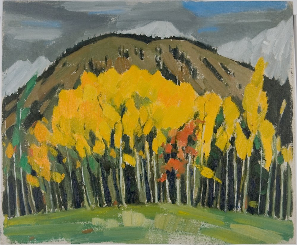
- Colour: yellow, green. Across the bottom is grass, then a bank of yellow aspens across the main part of the picture. Above them, a hill can be seen and snowy peaks rise up behind into grey clouded sky.
1 image
- Title
- Aspens
- Date
- 1950 – 1960
- Medium
- oil on canvas
- Dimensions
- 30.5 x 25.5 cm
- Description
- Colour: yellow, green. Across the bottom is grass, then a bank of yellow aspens across the main part of the picture. Above them, a hill can be seen and snowy peaks rise up behind into grey clouded sky.
- Subject
- landscape
- mountain
- Canadian Rockies
- Credit
- Gift of Catharine Robb Whyte, O. C., Banff, 1968
- Catalogue Number
- WyP.01.110
Images
This material is presented as originally created; it may contain outdated cultural descriptions and
potentially offensive content.
Read more.
[Athabaska Falls 83C/12, Alberta]
https://archives.whyte.org/en/permalink/catalogue23455
- Medium
- Library - Maps and blueprints (unannotated; published)
- Map
- Published Date
- 1955
- Publisher
- Dept. of National Defence
- Call Number
- NTS
- 83C/12
- Publisher
- Dept. of National Defence
- Published Date
- 1955
- Physical Description
- 1 map : col
- Scale
- Scale: 1:50,000
- Relief: Contour interval 100'
- Subjects
- Athabaska Falls
- Alberta
- Notes
- National Topographic System
- Call Number
- NTS
- 83C/12
- Collection
- Archives Library
This material is presented as originally created; it may contain outdated cultural descriptions and
potentially offensive content.
Read more.
[Atlin 104N, B.C.]
https://archives.whyte.org/en/permalink/catalogue24007
- Medium
- Library - Maps and blueprints (unannotated; published)
- Map
- Published Date
- 1954
- Publisher
- Dept. of Mines and Technical Surveys
- Call Number
- NTS
- 104N
- Publisher
- Dept. of Mines and Technical Surveys
- Published Date
- 1954
- Physical Description
- 1 map : col
- Scale
- Scale: 1:250,000
- Relief: Contour interval 500 ft.
- Subjects
- Atlin
- British Columbia
- Notes
- National Topographic System
- Accession Number
- 3000
- Call Number
- NTS
- 104N
- Collection
- Archives Library
This material is presented as originally created; it may contain outdated cultural descriptions and
potentially offensive content.
Read more.
[Banff 820/4 East, Alta.-B.C.]
https://archives.whyte.org/en/permalink/catalogue23479
- Medium
- Library - Maps and blueprints (unannotated; published)
- Map
- Published Date
- 1959
- Publisher
- Dept. of Mines and Technical Surveys
- Call Number
- NTS
- 820/4E
- Publisher
- Dept. of Mines and Technical Surveys
- Published Date
- 1959
- Physical Description
- 1 map : col
- Scale
- Scale: 1:50,000
- Relief: Contour interval 100 ft.
- Subjects
- Banff
- Alberta/British Columbia
- Notes
- National Topographic System
- Dup in map room
- Dup in research room
- Accession Number
- 718
- 3000
- Call Number
- NTS
- 820/4E
- Collection
- Archives Library
This material is presented as originally created; it may contain outdated cultural descriptions and
potentially offensive content.
Read more.
[Banff 820/4 West, Alta.-B.C.]
https://archives.whyte.org/en/permalink/catalogue23480
- Medium
- Library - Maps and blueprints (unannotated; published)
- Map
- Published Date
- 1959
- Publisher
- Dept. of Mines and Technical Surveys
- Call Number
- NTS
- 829/4W
- Publisher
- Dept. of Mines and Technical Surveys
- Published Date
- 1959
- Physical Description
- 1 map : col
- Scale
- Scale: 1:50,000
- Relief: Contour interval 100 ft.
- Subjects
- Banff
- Alberta/British Columbia
- Notes
- National Topographic System
- Dup in map room
- Dup in research room
- Accession Number
- 718
- 3000
- Call Number
- NTS
- 829/4W
- Collection
- Archives Library
This material is presented as originally created; it may contain outdated cultural descriptions and
potentially offensive content.
Read more.