Narrow Results By
Balfour Hut Registers
https://archives.whyte.org/en/permalink/descriptions57646
- Part Of
- Alpine Club of Canada fonds
- Scope & Content
- Sub-series of hut registers from the Balfour (Rob Ritchie) Hut produced by the Alpine Club of Canada between 1966 and 2019. Registers include entries from visitors to the huts which pertain to individuals' hiking and climbing trips; details of specific events which occurred while staying at the hut…
- Date Range
- 1966-2001
- 2007-2019
- Reference Code
- M200 / IV / I
- Description Level
- 4 / Sub-series
- GMD
- Textual record
- Organization record
- Part Of
- Alpine Club of Canada fonds
- Description Level
- 4 / Sub-series
- Fonds Number
- M200
- V14
- S6
- Series
- M200 / IV: Hut Registers
- Sous-Fonds
- M200
- Sub-Series
- M200 / IV / I: Balfour Hut Registers
- Accession Number
- accn. 2376
- accn. 3298
- accn. 3560
- accn. 7779
- accn. 2023.10
- accn. 2023.31
- accn. 2023.15
- Reference Code
- M200 / IV / I
- Responsibility
- Registers produced by Alpine Club of Canada
- Date Range
- 1966-2001
- 2007-2019
- Physical Description
- 20 cm of textual records 9 volumes
- History / Biographical
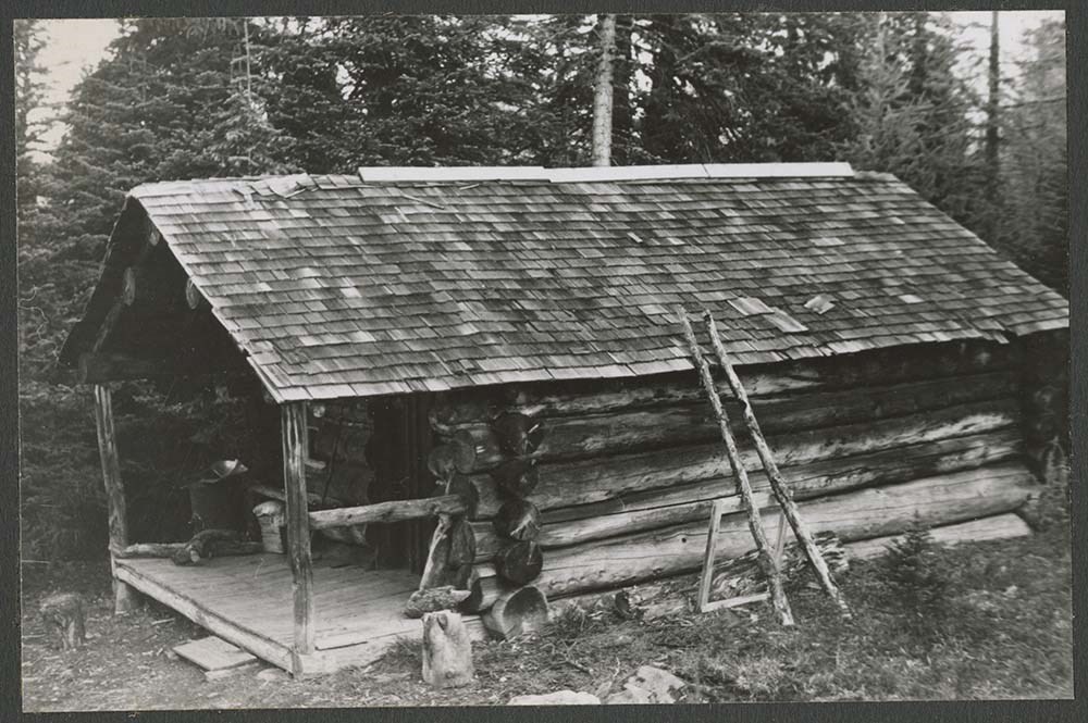
- According to the Alpine Club of Canada's website: "The Rob Ritchie Hut, also known as the Balfour Hut, is found on low, rocky hills at the toe of the Vulture Glacier, approximately 28 km northwest of the town of Lake Louise, AB. It is east of Balfour Pass and the Continental divide, just inside the Banff National Park boundary.[...] The Rob Ritchie Hut, also known as the Balfour Hut, is found on low, rocky hills at the toe of the Vulture Glacier, approximately 28 km northwest of the town of Lake Louise, AB. It is east of Balfour Pass and the Continental divide, just inside the Banff National Park boundary. This is the half-way mark for the Wapta Traverse and is usually used in conjunction with the other huts in this chain while attempting this classic cross-glacier ski trip. Usual approach is from Bow Hut through the Olive/St. Nicholas Col then down the gentle and pleasant Vulture Glacier to Balfour Pass, where the hut sits on a section of moraine beneath the impressive bulk of Mt. Balfour. Though most people will spend one night at the R.J. Ritchie (Balfour) Hut before continuing on to Scott Duncan, there is potential for good skiing here, especially on the Diableret Glacier which sits northwest of Mt. Balfour and makes for a fantastic run on a clear day! There is also an optional route to the summit of Mt. Gordon from this hut, which would be an excellent loop trip if combined with the normal route back towards Bow Hut. Use your imagination and some neat trip ideas will present themselves!"
- Scope & Content
- Sub-series of hut registers from the Balfour (Rob Ritchie) Hut produced by the Alpine Club of Canada between 1966 and 2019. Registers include entries from visitors to the huts which pertain to individuals' hiking and climbing trips; details of specific events which occurred while staying at the hut, wildlife sightings, custodial issues and updates, and related topics. The sub-series is separated into individual hut registers, arranged by date:
- M200 / IV / I / 1: Balfour Hut [Register] [1966-1971]
- M200 / IV / I / 2: Balfour Pass Hut [1971-1972]
- M200 / IV / I / 3: Balfour Pass Hut Register [1973-1974]
- M200 / IV / I / 4: Balfour Pass Hut [register 1974-1982]
- M200 / IV / I / 5: "Balfour Hut" [register] Sept. 2, 1982 - Nov. 17, 1989
- M200 / IV / I / 6: Balfour Hut Journal Nov. 22, 1989 - Apr. 25, 1997
- M200 / IV / I / 7: Balfour Hut Register [1997 -2001]
- M200 / IV / I / 8: Balfour Hut Register 2007 - 2015
- M200 / IV / I / 9: Balfour Hut register 2011 - 2019
- Name Access
- Alpine Club of Canada
- Subject Access
- Huts
- Cabins
- Cabins and shelters
- Backcountry skiing
- Banff National Park
- Buildings and facilities
- Climbing
- Environment and Nature
- Lake Louise
- Mountaineering
- Mountains
- Ski mountaineering
- Sports and leisure
- Sports and recreation
- Winter sports
- Wapta Traverse
- Geographic Access
- Canada
- Alberta
- Banff National Park
- Lake Louise, AB
- Access Restrictions
- Restrictions may apply
- Language
- English
- French
- German
- Japanese
- Spanish
- Biographical Source Notes
- Alpine Club of Canada website: https://www.alpineclubofcanada.ca/rob-ritchie-balfour-hut/"
- Title Source
- Title based on contents of sub-series
- Processing Status
- Processed
This material is presented as originally created; it may contain outdated cultural descriptions and
potentially offensive content.
Read more.
Bon Echo Hut Registers
https://archives.whyte.org/en/permalink/descriptions57649
- Part Of
- Alpine Club of Canada fonds
- Scope & Content
- Sub-series of hut registers from the Bon Echo Hut produced by the Alpine Club of Canada between 1964 and 2006. Registers include entries from visitors to the huts which pertain to individuals' hiking and climbing trips; details of specific events which occurred while staying at the hut, wildlife si…
- Date Range
- 1964-2006
- Reference Code
- M200 / IV / L
- Description Level
- 4 / Sub-series
- GMD
- Textual record
- Organization record
- Part Of
- Alpine Club of Canada fonds
- Description Level
- 4 / Sub-series
- Fonds Number
- M200
- V14
- S6
- Series
- M200 / IV: Hut Registers
- Sous-Fonds
- M200
- Sub-Series
- M200 / IV / L: Bon Echo Hut Registers
- Accession Number
- accn. 7779
- accn. 2014.8278
- Reference Code
- M200 / IV / L
- Responsibility
- Registers produced by Alpine Club of Canada
- Date Range
- 1964-2006
- Physical Description
- 25 cm of textual records 8 volumes
- History / Biographical
- According to the Alpine Club of Canada website: "The rock climbing at Mazinaw Lake is some of the finest in Ontario. The area boasts quartzite cliffs up to 100m high that rise vertically out of the lake. The routes are all traditional and range in grades from 5.0 to 5.11, with the most popular routes in the 5.4 to 5.9 range. The exposure and length of the routes make for an adventure unlike any other in the province. The Bon Echo Hut on the lake is operated by the Toronto Section which also operates a boat to ferry climbers to and from the climbs. The hut is comfortable and an excellent place to meet other climbers and get information on the climbs. The area also offers excellent swimming and hiking. The hut is a single-room wooden structure with a fireplace and kitchen equipped with propane stoves and a large dining table. There is a sauna located near the lake. The hut is not used for sleeping, but is a day hut and cook shelter for those staying at the campsites immediately adjacent to the hut. Bon Echo is located approximately 300 km north east of Toronto on the east side of Mazinaw Lake, a mile north of the Mazinaw Rock and Bon Echo Provincial Park. The drive to the public dock takes three to four hours from Toronto or one and a half hours from Ottawa. The hut can be reached by hiking overland, but this would take an entire day. Boating to the hut is much more convenient."
- Scope & Content
- Sub-series of hut registers from the Bon Echo Hut produced by the Alpine Club of Canada between 1964 and 2006. Registers include entries from visitors to the huts which pertain to individuals' hiking and climbing trips; details of specific events which occurred while staying at the hut, wildlife sightings, custodial issues and updates, and related topics. The sub-series is separated into individual hut registers, arranged by date:
- M200 / IV / L / 1: [Bon Echo - register Jan 28, 1964 - Nov. 25, 1967]
- M200 / IV / L / 2: [Bon Echo hut register Feb. 24, 1968 - Aug. 27, 1972]
- M200 / IV / L / 3: Bon Echo hut book #3 Sept 23, 1972 - Aug. 27, 1978
- M200 / IV / L / 4: Bon Echo Hut book #4 Sept. 2, 1978 - July 13, 1984.
- M200 / IV / L / 5: [Bon Echo Hut Register] July 14, 1984 - Apr 20, 1987
- M200 / IV / L / 6: ACC Bon Echo Log Hut book #6 May 9, 1987 - July 4, 1993
- M200 / IV / L / 7: [Bon Echo Hut Register] vol. 7 July 9, 1993 - Aug. 24, 1997
- M200 / IV / L / 8: Bon Echo Hut Register 1998-2006
- Notes
- M200 / IV / L / 3: Bon Echo hut book #3 Sept 23, 1972 - Aug. 27, 1978 included a colour photographic print that has been separated into V14 / III / C / PA under the same title: Bon Echo hut book #3 Sept 23, 1972 - Aug. 27, 1978. The print was found loose inside the hut register. M200 / IV / L / 6: ACC Bon Echo Log Hut book #6 May 9, 1987 - July 4, 1993 included a photographic print that has been separated into V14 / III / C / PA under the same title: ACC Bon Echo Log Hut book #6 May 9, 1987 - July 4, 1993. The print was found loose inside the hut register. M200 / IV / L / 8: Bon Echo Hut Register 1998-2006 contained loose bird feathers that have been removed from page 173.
- Name Access
- Alpine Club of Canada
- Subject Access
- Huts
- Cabins and shelters
- Alpine Club of Canada
- Birds
- Boats
- Buildings and facilities
- Climbing
- Environment
- Environment and Nature
- Hiking
- Mountaineering
- Property
- Sports and leisure
- Sports and recreation
- Swimming
- Geographic Access
- Canada
- Ontario
- Toronto
- Mazinaw Lake
- Bon Echo Provincial Park
- Access Restrictions
- Restrictions may apply
- Language
- English
- French
- Spanish
- German
- Conservation
- Some hut registers contain loose pages. Some book/register bindings are broken.
- Biographical Source Notes
- The Alpine Club of Canada website: https://www.alpineclubofcanada.ca/bon-echo-hut-toronto-section/
- Title Source
- Title based on contents of sub-series
- Processing Status
- Processed
This material is presented as originally created; it may contain outdated cultural descriptions and
potentially offensive content.
Read more.
Bow Hut Registers
https://archives.whyte.org/en/permalink/descriptions57641
- Part Of
- Alpine Club of Canada fonds
- Scope & Content
- Sub-series of hut registers from the Bow Hut produced by the Alpine Club of Canada between 1968 and 2019. Registers include entries from visitors to the huts which pertain to individuals' hiking and climbing trips; details of specific events which occurred while staying at the hut, wildlife sightin…
- Date Range
- 1968 - 1977
- 1983 - 2006
- 2010 - 2023
- Reference Code
- M200 / IV / F
- Description Level
- 4 / Sub-series
- GMD
- Textual record
- Organization record
- Part Of
- Alpine Club of Canada fonds
- Description Level
- 4 / Sub-series
- Fonds Number
- M200
- V14
- S6
- Series
- M200 / IV: Hut Registers
- Sous-Fonds
- M200
- Sub-Series
- M200 / IV / F: Bow Hut Registers
- Accession Number
- accn. 2023.32
- accn. 2023.15
- accn. 2023.20
- accn. 2014.8293
- accn. 2023.19
- accn. 8002
- accn. 7779
- accn. 2023.10
- accn. 6465
- accn. 6623
- accn. 6766
- accn. 2376
- accn. 3296
- accn. 3970
- accn. 5215
- accn. 2023.06
- accn. 2024.20
- Reference Code
- M200 / IV / F
- Responsibility
- Registers produced by the Alpine Club of Canada
- Date Range
- 1968 - 1977
- 1983 - 2006
- 2010 - 2023
- Physical Description
- 66 cm of textual records (34 volumes)
- History / Biographical
- According to the Alpine Club of Canada website and their Backcountry Huts: Bow Hut Info Sheet: "The original Bow Hut project was initiated by Peter Fuhrmann, funded by Peter and Catharine Whyte and was constructed in 1968 by members of various groups including the Calgary Ski Club and the ACC. The hut was built near Bow Glacier to facilitate ski tourers and mountaineers entering the Wapta via Bow Lake, the easiest and most natural route to the icefields. Fiberglass igloos had been established at both the Peyto Glacier and Balfour Pass in the years prior, and with the building of a deluxe 14-person facility at a location between the two, the vision of a system of huts on the Wapta/Waputik Icefields was taking shape. None of those responsible for the project, however, could have predicted the amount of use and the level of abuse that the original Bow Hut would endure. The hut was abused from the beginning, and saw very little regular maintenance or upkeep. By the 1980s the place was a total hole. The hut was used as a flop house, the snow within several hundred feet of the hut had been contaminated by the outhouses and by indiscriminate waste disposal, and some estimates put the number of users per year at 7,000 (19 people per night at a facility which was built to sleep 14!). The hut which was described upon its completion as the “the Ritz” had metamorphosed into the “Bow Ghetto”. By the mid-1980s it was evident that the facility required radical change. In 1989, under the direction of the ACC’s Huts Committee Chairman Mike Mortimer, that radical change took place. The original hut had been built on a site which was non-porous and therefore had no drainage – a problem that led to the contaminated water and snow. Plans were made for a new hut in a more environmentally sensitive location and fund-raising began. The new Bow Hut was constructed for $98,000, raised primarily through the Calgary and Edmonton sections of the Club. Design concerns in the new hut included proper waste disposal, spacious and bright common areas and sleeping rooms which were both increased in size from the original hut and separated from the common areas to facilitate use by may groups at one time. The palatial new Bow Hut was opened in the fall of 1989 to rave reviews and is presently operated by the ACC. The hut today is a far cry from the original Balfour and Peyto fiberglass igloos, which a Banff Warden predicted in the late ’60s “will only serve the few hardy ski mountaineers who can accept the hardships of carrying and skiing with heavy loads and are willing to put up with discomfort during the night in bad weather”. It’s an even further cry from the abused state of the original Bow Hut and now serves as a stopover for many summer and winter trips."
- Scope & Content
- Sub-series of hut registers from the Bow Hut produced by the Alpine Club of Canada between 1968 and 2019. Registers include entries from visitors to the huts which pertain to individuals' hiking and climbing trips; details of specific events which occurred while staying at the hut, wildlife sightings, custodial issues and updates, and related topics. The sub-series is separated into individual hut registers, arranged by date:
- M200 / IV / F / 1: Bow Glacier Hut [1968 - 1971 register]
- M200 / IV / F / 2: Bow Glacier Hut Register [1971 - 1973]
- M200 / IV / F / 3: Bow Glacier Hut Register [1973 -1975]
- M200 / IV / F / 4: Bow Hut register [1975 -1977]
- M200 / IV / F / 5: Bow Hut [register 1983 - 1984]
- M200 / IV / F / 6: Bow Hut Register [1984-1986]
- M200 / IV / F / 7: [Bow Hut Register Dec. 17, 1986 - June 19, 1989]
- M200 / IV / F / 8: Bow Hut [1989 - 1991]
- M200 / IV / F / 9: Bow Hut 1991 - 1993
- M200 / IV / F / 10: [Bow Hut Registers 1992 - 94]
- M200 / IV / F / 11: "Bow Hut Register" Sept. 30, 1994 - Aug. 28, 1995
- M200 / IV / F / 12: Bow Hut Register Sept. 16, 1995 - June 27, 1996
- M200 / IV / F / 13: [Bow Hut Dec. 1995 - March 2000 Register]
- M200 / IV / F / 14: Bow Hut Register June 29, 1996 - Mar 29, 1997
- M200 / IV / F / 15: Bow Hut register Mar 29, 1997 - Nov. 14, 1997
- M200 / IV / F / 16: "Bow Hut Register" November 24, 1997 - September 26, 1998
- M200 / IV / F / 17: Bow Hut Register [2000 - 2001]
- M200 / IV / F / 18: Bow Hut Register [2001 - 2002]
- M200 / IV / F / 19: Bow Hut Apr 18, 2002 - Feb 24, 2003
- M200 / IV / F / 20: Bow Hut Apr 8, 2003 - July 18, 2004
- M200 / IV / F / 21: Bow Hut July 18, 2004 - Aug 4, 2004
- M200 / IV / F / 22: Bow Hut Register 2004 - 2006
- M200 / IV / F / 23: Bow Hut Register 2006
- M200 / IV / F / 24: Bow Hut Register April 2009 - August 2010
- M200 / IV / F / 25: 2010 - 2012 Bow Hut Register
- M200 / IV / F / 26: Bow Hut 2012 - 2014
- M200 / IV / F / 27: Bow Hut Register [2014/15]
- M200 / IV / F / 28: Hut Register Bow Hut [2015-2016]
- M200 / IV / F / 29: Bow Hut Register, 2016 - 2018
- M200 / IV / F / 30: Bow Hut Register 2018-2019
- M200 / IV / F / 31: [100 YR SWISS CENTENNIAL CLIMB 1999: Faye Summit notes. Bow Hut OCT - DEC 1998]
- M200 / IV / F / 32: Bow Hut Register [2018-2020]
- M200 / IV / F / 33: Bow Hut Register [2021-2022]
- M200 / IV / F / 34: Bow Hut Register [2022-2023]
- Name Access
- Alpine Club of Canada
- Subject Access
- Huts
- Cabins
- Cabins and shelters
- Environment
- Environment and Nature
- Mountain
- Mountaineering
- Parks
- Parks Canada
- Sports and recreation
- Winter sports
- Geographic Access
- Canada
- Bow Glacier
- Banff National Park
- Lake Louise, AB
- Access Restrictions
- Restrictions may apply
- Reproduction Restrictions
- Contains personal information
- Language
- English
- French
- German
- Spanish
- Related Material
- M200 / V / A / 156
- Biographical Source Notes
- The Alpine Club of Canada website: https://www.alpineclubofcanada.ca/bow-hut/ The Alpine Club of Canada Backcountry Huts: Bow Hut Info Sheet pdf: https://www.alpineclubofcanada.ca/wp-content/uploads/2023/04/BowHut-InfoSheet.pdf
- Title Source
- Title based on contents of sub-series
- Processing Status
- Processed
This material is presented as originally created; it may contain outdated cultural descriptions and
potentially offensive content.
Read more.
Calgary Mountain Club - textual
https://archives.whyte.org/en/permalink/descriptions55061
- Part Of
- Chic Scott fonds
- Scope & Content
- Series consists of correspondence, published materials and other textual records pertaining to the Calgary Mountain Club.
- Date Range
- 1978 - 1998
- Reference Code
- M57 / XII
- Description Level
- 3 / Series
- GMD
- Textual record
- Part Of
- Chic Scott fonds
- Description Level
- 3 / Series
- Fonds Number
- M57 / V40 / S47
- Series
- M57 / XII: Calgary Mountain Club
- Sous-Fonds
- M57
- Sub-Series
- M57 / XII / A: News clippings
- M57 / XII / B: Correspondence
- M57 / XII / C: Newsletters
- M57 / XII / D: Collected publications
- Accession Number
- 5506
- 6772
- Reference Code
- M57 / XII
- GMD
- Textual record
- Date Range
- 1978 - 1998
- Physical Description
- 60 cm of textual records
- History / Biographical
- Originally, the CMC was the meeting point of Canada's top climbers who gathered together to plan expeditions, plot potential first ascents and discuss the advancement of their chosen sport. Today, it still provides this function but also serves as a means for new climbers to meet.
- Scope & Content
- Series consists of correspondence, published materials and other textual records pertaining to the Calgary Mountain Club.
- Notes
- Series consists of four subseries: M57 / XII / A: News clippings M57 / XII / B: Correspondence M57 / XII / C: Newsletters M57 / XII / D: Collected publications
- Name Access
- Scott, Chic
- Calgary Mountain Club
- Subject Access
- Communications
- Correspondence
- Organizations
- Exploration
- Travel
- Club
- Publication
- Mountaineering
- Mountains
- Climbing
- Community events
- Newspaper
- Sports and recreation
- Geographic Access
- Canada
- Alberta
- Calgary
- Language
- English
- Related Material
- V40 / XII
- Biographical Source Notes
- http://www.calgarymountainclub.com/main.php?page=about
- Title Source
- Title based on contents of file
- Processing Status
- Processed
This material is presented as originally created; it may contain outdated cultural descriptions and
potentially offensive content.
Read more.
Calgary Mountain Club - visual
https://archives.whyte.org/en/permalink/descriptions55062
- Part Of
- Chic Scott fonds
- Scope & Content
- Series consists of photographs pertaining to the Calgary Mountain Club and its activities.
- Date Range
- 1978 - 1998
- Reference Code
- V40 / XII
- Description Level
- 3 / Series
- GMD
- Photograph
- Digital image
- Part Of
- Chic Scott fonds
- Description Level
- 3 / Series
- Fonds Number
- M57 / V40 / S47
- Series
- V40 / XII: Calgary Mountain Club
- Sous-Fonds
- V40
- Accession Number
- 6772
- Reference Code
- V40 / XII
- Date Range
- 1978 - 1998
- Physical Description
- photographs
- History / Biographical
- Originally, the CMC was the meeting point of Canada's top climbers who gathered together to plan expeditions, plot potential first ascents and discuss the advancement of their chosen sport. Today, it still provides this function but also serves as a means for new climbers to meet.
- Scope & Content
- Series consists of photographs pertaining to the Calgary Mountain Club and its activities.
- Name Access
- Scott, Chic
- Calgary Mountain Club
- Subject Access
- Organizations
- Exploration
- Travel
- Club
- Mountaineering
- Mountains
- Climbing
- Community events
- Sports and recreation
- Geographic Access
- Canada
- Alberta
- Calgary
- Canadian Rocky Mountains
- Access Restrictions
- Reference only
- Reproduction Restrictions
- Restricted: copyright remains with creator not museum
- Language
- English
- Related Material
- M57 / XII
- Biographical Source Notes
- http://www.calgarymountainclub.com/main.php?page=about
- Title Source
- Title based on contents of file
- Processing Status
- Processed
This material is presented as originally created; it may contain outdated cultural descriptions and
potentially offensive content.
Read more.
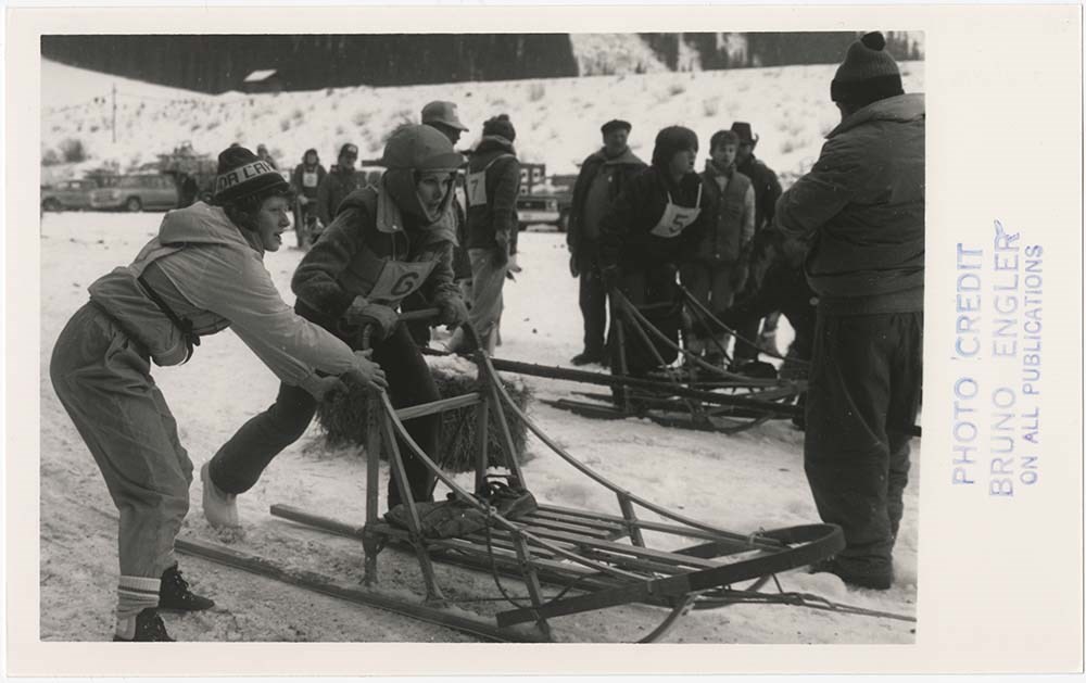
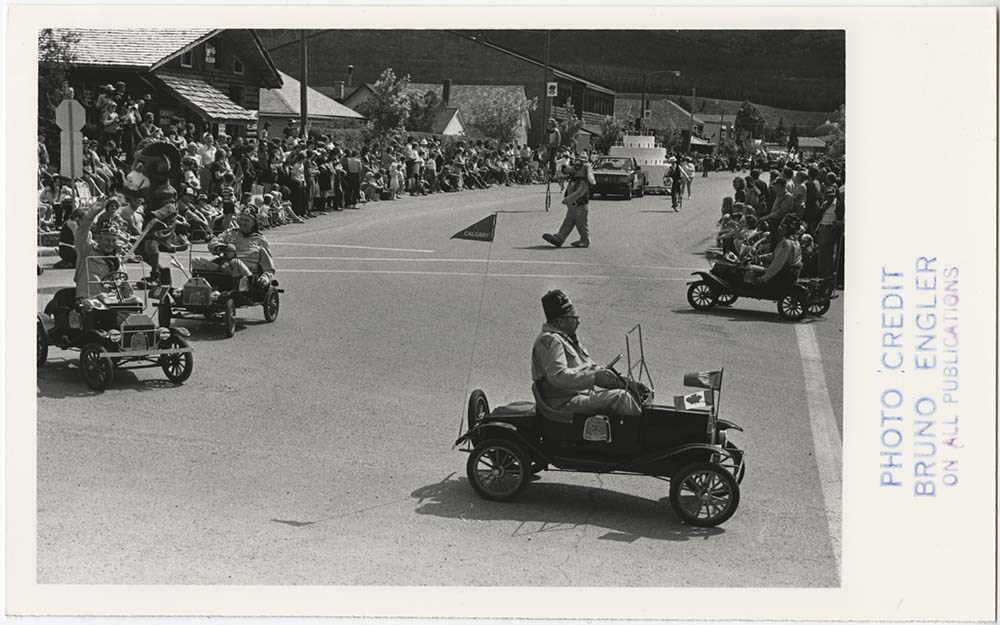
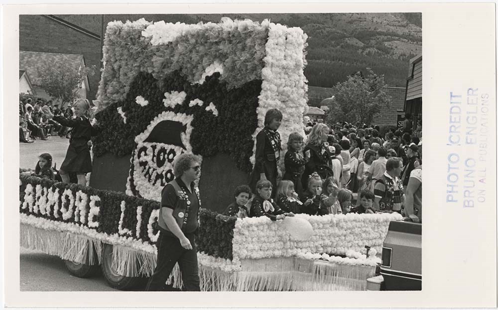
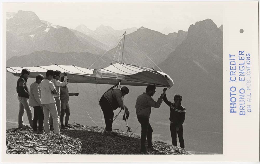
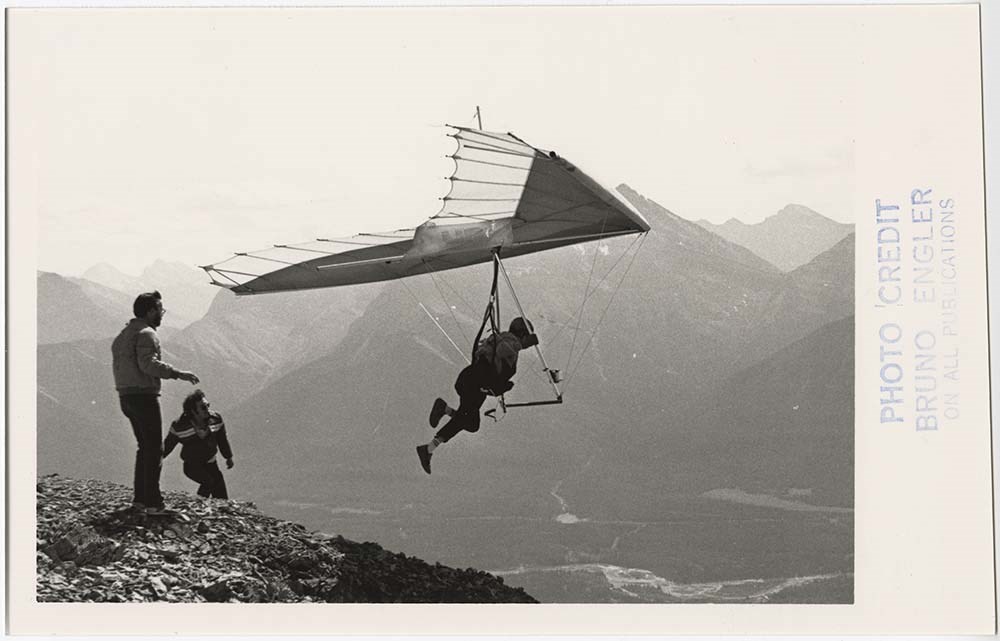
Canmore Events
https://archives.whyte.org/en/permalink/descriptions56875
- Part Of
- Bruno Engler fonds
- Scope & Content
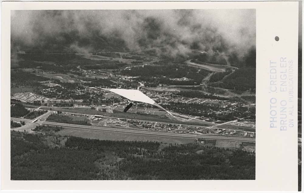
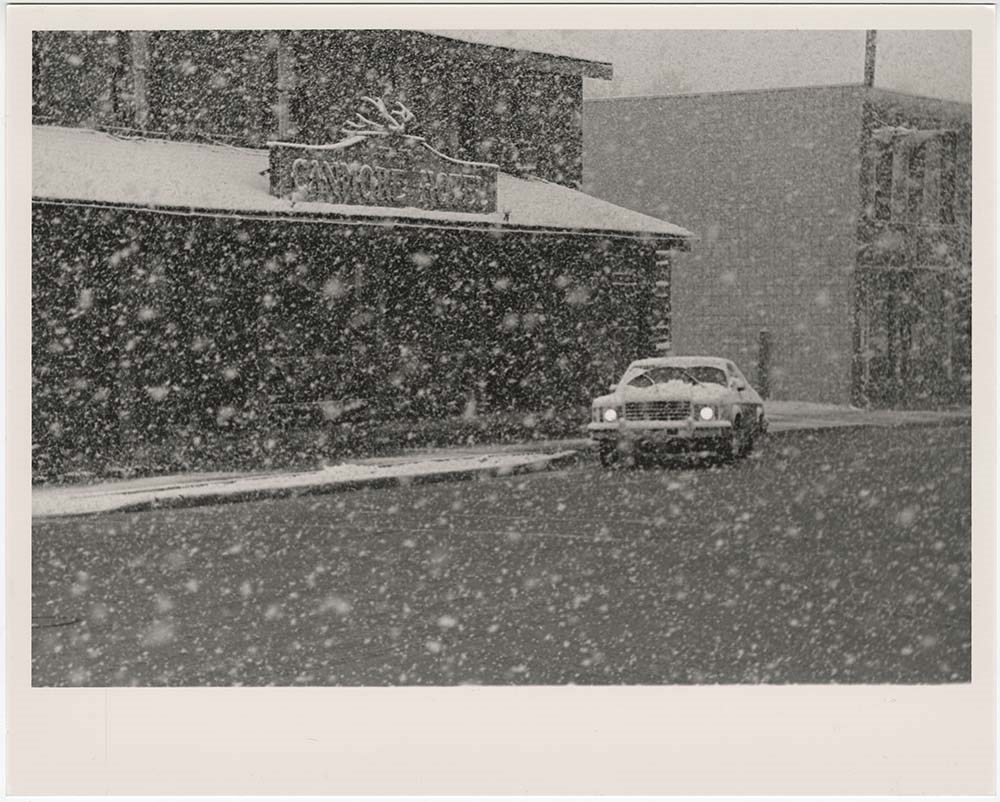
- File pertains to 129 b&w prints of various Canmore events. Includes parades, dogsledding, biathlons, rodeos, various races, a man paragliding, various fires, the Canmore Centennial celebrations, Grassi Lakes, and interior shots of a building, possibly a new hospital.
- Date Range
- 1974-1992
- Reference Code
- V190 / VI / C / iii / PA - 01 to PA - 129
- Description Level
- 5 / File
- GMD
- Photograph
16 images
- Part Of
- Bruno Engler fonds
- Description Level
- 5 / File
- Fonds Number
- M323 / S40 / V190
- Series
- VI : Retained file, C : Alphabetical order
- Sous-Fonds
- V190
- Sub-Series
- iii : Canmore Events
- Accession Number
- 7436
- Reference Code
- V190 / VI / C / iii / PA - 01 to PA - 129
- GMD
- Photograph
- Date Range
- 1974-1992
- Physical Description
- 129 photographs : b&w ; 25.2 x 20.2 cm or smaller
- History / Biographical
- See fonds level description
- Scope & Content
- File pertains to 129 b&w prints of various Canmore events. Includes parades, dogsledding, biathlons, rodeos, various races, a man paragliding, various fires, the Canmore Centennial celebrations, Grassi Lakes, and interior shots of a building, possibly a new hospital.
- Subject Access
- Activities
- Airplanes
- Aerial photography
- Animals
- Automobiles
- Buildings
- Businesses
- Ceremony
- Children
- Community events
- Community life
- Cowboys
- Cross-country skiing
- Dog Teams
- Dogs
- Dogsledding
- Ducks
- Entertainment
- Family and personal life
- Fire
- Grassi Lakes
- Horses
- Mountains
- Olympic Games (Winter)
- Parade
- Public entertainment
- Public events
- Race
- Recreation
- Rodeo
- Scenery
- Ski areas
- Ski racing
- Sled dogs
- Sports and recreation
- Weather
- Winter
- Geographic Access
- Canmore
- Alberta
- Language
- English
- Creator
- Engler, Bruno
- Title Source
- Original title kept
- Processing Status
- Processed
Images


This material is presented as originally created; it may contain outdated cultural descriptions and
potentially offensive content.
Read more.
Cartographic Materials
https://archives.whyte.org/en/permalink/descriptions23065
- Part Of
- Hans Gmoser fonds
- Scope & Content
- Cartographic materials in these four oversized files consist of the following:
- Date Range
- 1914-1973
- Reference Code
- M224 / O.S. Cartographic
- Description Level
- 5 / File
- Part Of
- Hans Gmoser fonds
- Description Level
- 5 / File
- Series
- IV.C. Textual records: Cartographic records
- Accession Number
- 7361, 7877, 8111
- Reference Code
- M224 / O.S. Cartographic
- Date Range
- 1914-1973
- Physical Description
- 48 cartographic records.
- Scope & Content
- Cartographic materials in these four oversized files consist of the following:
- Subject Access
- Discovery and Exploration
- Environment and Nature
- Family and personal life
- Sports and Recreation
- Title Source
- Title based on contents.
- Content Details
- Folder 1 Map on heavy paper, wrapped in plastic. “A Reconnaissance Topographic Map Suveyed and edited by Bradford Washburn” printed in Bern, Switzerland. Centred on Mt. McKinley.- From 7361. Palliser- Kananaskis Area British Columbia and Alberta- Publication No. 1962- Reprinted by the Surveys and Mapping Branch, Department of Mines and Technical Surveys, Ottawa. Mistaya British Columbia and Alberta- Compiled, drawn and printed at the office of the Surveyor General, Ottawa, 1931. Reprinted with corrections at the Surveys and Mapping Branch, Ottawa, 1950. National Topographic Series. Yoho British Columbia and Alberta- Compiled, drawn and printed at the office of the Surveyor General, Ottawa, 1932. Reprinted with corrections at the Surveys and Mapping Branch, Ottawa, 1952. National Topographic Series. Price 25 cents. Invermere British Columbia Kootenay Land District- National Topographic System- First Status Edition compiled and produced by the Geographic Division, Surveys, and Mapping Branch, Dept. of Lands, Forests and Water Resources, Victoria, BC 1964-65- annotated Beaton British Columbia Kootenay Land District- National Topographic System- First Status Edition compiled and produced by the Geographic Division, Surveys, and Mapping Branch, Dept. of Lands, Forests and Water Resources, Victoria, BC 1964-66- annotated Lardeau British Columbia Kootenay Land District- National Topographic System- First Status Edition compiled and produced by the Geographic Division, Surveys, and Mapping Branch, Dept. of Lands, Forests and Water Resources, Victoria, BC 1963- annotated Mount McKinley Alaska, Published by the Museum of Science, Boston, Mass, USA and the Swiss Foundation for Alpine Research, Zurich. 1960. Centennial Range Yukon Territory- M.C.R. 7 Edition 1- Produced and printed 1967 by the Surveys and Mapping Branch, Department of Energy, Mines and Resources- maps printed in 1961-62- annotated British Columbia Land Recording Dists.- Land Commissioner’s Offices- Department of Lands and Forests- first published 1957- Updated Nov. 1, 1960. Master Site Plan Bugaboo Creek Lodge Project number 6844- June 18, 1973- Cohos Delesalle & Evamy. Folder 2 Boundary Between Alberta and BC- Athabasca Pass- Sheet No. 27A – annotated- centered on Jasper Park Boundary Between Alberta and BC-All below Wheeler Maps (by hand) used for the Great Divide as per Chic-no topographical maps used for both Hans and similar maps were used by Chic bottom rip taped- Sheet No. 20- Drawn and printed by the Topographical Survey of Canada, Ottawa - centered on Clearwater forest and Lyell Icefield at bottom right Boundary Between Alberta and BC- Sheet No. 15- Drawn and printed at the Surveyor General’s Office, Ottawa, Canada- centered on Rocky Mountains Park Boundary Between Alberta and BC - Sheet No. 19- Drawn and printed at the Surveyor General’s Office, Ottawa, Canada- centered on centered on Clearwater Forest with Mt. Alan Campbell at bottom Boundary Between Alberta and BC- Sheet No. 25- annotated- Drawn and printed by the Topographical Survey of Canada, Ottawa - centered on Jasper Park with Chisel Peak at bottom Boundary Between Alberta and BC- Sheet No. 19- dirt and annotated- revised 1925- drawn and printed by the Topographical Survey of Canada, Ottawa- centered on Clearwater and Push Pass W. Boundary Between Alberta and BC- annotated- Sheet 16- revised 1925- drawn and printed by the Topographical Survey of Canada, Ottawa- centered on Yoho Park and Rocky Mountains Park Steele Glacier- Topographical Survey 1967 Arial Photography 1951 Mount St. Elias Canada- United State of America- Produced and Printed by the Surveys and Mapping Branch, Department of Mines and Technical Surveys 1962 from air photographs taken in 1951 and 1956- annotated Woolsey Glacier- Revelstoke National Park British Columbia – Printed by the Surveys and Mapping Branch Department of Energy, Mines and Resources- 1967 Windermere Kootenay District- Map 165A Issued 1918- Reprinted by the Surveys and Mapping Branch, Department of Mines and Technical Surveys, Ottawa. Folder 3 Boundary Between Alberta and BC- Sheet No. 20- heavily annotated- revised 1925- drawn and printed by the Topographical Survey of Canada, Ottawa- centered on Clearwater Forest, Saskatchewan Glacier at top left Boundary Between Alberta and BC- Sheet No. 18- heavily ripped- annotated - notes on back- revised 1925- drawn and printed by the Topographical Survey of Canada, Ottawa- centered on Clearwater Forest, Mt Mummery at bottom Boundary Between Alberta and BC- Sheet No. 17 (in pencil “A and B”)- annotated - heavily ripped- drawn and printed at the Surveyor Generals’ Office- centered on Clearwater Forest and Yoho Park Boundary Between Alberta and BC- Sheet No. 26- annotated- revised 1925- drawn and printed by the Topographical Survey of Canada, Ottawa- centered on Jasper Park and Icefields Boundary Between Alberta and BC- Sheet No. 17- revised 1925- drawn and printed by the Topographical Survey of Canada, Ottawa- centered on Clearwater Forest and Yoho Park Boundary Between Alberta and BC- Sheet No. 28- stained- centered on Jasper Park Boundary Between Alberta and BC- Sheet No. 24- annotated- revised edition, 1925- drawn and printed by the Topographical Survey of Canada, Ottawa- centered on Jasper Park Boundary Between Alberta and BC- Sheet No. 16- annotated- revised 1925- drawn and printed by the Topographical Survey of Canada, Ottawa- centered on Yoho and Rocky Mountains Park Interprovincial Boundary Commission Boundary Between Alberta and British Columbia. Revised edition 1925 drawn and printed by the Topographical Survey of Canada, Ottawa. Sheet No. 27. Following maps are from accession 7877. Interprovincial Boundary Commission Boundary Between Alberta and British Columbia. Surveyed 1920. Drawn and printed by the Topographical Survey of Canada, Ottawa. Sheet No. 26. Interprovincial Boundary Commission Boundary Between Alberta and British Columbia. Surveyed 1920, 1921. Drawn and printed by the Topographical Survey of Canada, Ottawa. Sheet No. 25. Interprovincial Boundary Commission Boundary Between Alberta and British Columbia. Surveyed 1919, 1921. Drawn and printed by the Topographical Survey of Canada, Ottawa. Sheet No. 24. Interprovincial Boundary Commission Boundary Between Alberta and British Columbia. Revised edition 1925 drawn and printed by the Topographical Survey of Canada, Ottawa. Sheet No. 21. Interprovincial Boundary Commission Boundary Between Alberta and British Columbia. Revised edition 1925 drawn and printed by the Topographical Survey of Canada, Ottawa. Sheet No. 18. Interprovincial Boundary Commission Boundary Between Alberta and British Columbia. Surveyed 1913. Drawn and printed by the Topographical Survey of Canada, Ottawa. Sheet No. 13 A. Interprovincial Boundary Commission Boundary Between Alberta and British Columbia. Surveyed 1916. Drawn and printed by the Topographical Survey of Canada, Ottawa. Sheet No. 12 A. Interprovincial Boundary Commission Boundary Between Alberta and British Columbia. Surveyed 1916. Drawn and printed by the Topographical Survey of Canada, Ottawa. Sheet No. 11. Interprovincial Boundary Commission Boundary Between Alberta and British Columbia. Surveyed 1916. Drawn and printed by the Topographical Survey of Canada, Ottawa. Sheet No. 10. Interprovincial Boundary Commission Boundary Between Alberta and British Columbia. Surveyed 1916. Drawn and printed by the Topographical Survey of Canada, Ottawa. Sheet No. 9. Interprovincial Boundary Commission Boundary Between Alberta and British Columbia. Surveyed 1916. Drawn and printed by the Topographical Survey of Canada, Ottawa. Sheet No. 8. Interprovincial Boundary Commission Boundary Between Alberta and British Columbia. Surveyed 1916. Drawn and printed by the Topographical Survey of Canada, Ottawa. Sheet No. 6. Interprovincial Boundary Commission Boundary Between Alberta and British Columbia. Surveyed 1915. Drawn and printed by the Topographical Survey of Canada, Ottawa. Sheet No. 5. Interprovincial Boundary Commission Boundary Between Alberta and British Columbia. Surveyed 1914. Drawn and printed by the Topographical Survey of Canada, Ottawa. Sheet No. 4. Interprovincial Boundary Commission Boundary Between Alberta and British Columbia. Surveyed 1922. Drawn and printed by the Topographical Survey of Canada, Ottawa. Sheet No. 31. Interprovincial Boundary Commission Boundary Between Alberta and British Columbia. Surveyed 1922, 1924. Drawn and printed by the Topographical Survey of Canada, Ottawa. Sheet No. 30. Interprovincial Boundary Commission Boundary Between Alberta and British Columbia. Surveyed 1917. Drawn and printed by the Topographical Survey of Canada, Ottawa. Sheet No. 29.
- Processing Status
- Processed
This material is presented as originally created; it may contain outdated cultural descriptions and
potentially offensive content.
Read more.
Club photographs
https://archives.whyte.org/en/permalink/descriptions7214
- Part Of
- Alpine Club of Canada fonds
- Scope & Content
- Includes photographs of ACC property at Mount Assiniboine (accompanied by 2 maps - AC 018P); clubhouse view; move of library to Vancouver Public Library; Board meeting; closing party at the old clubhouse (AC 421P / 09-37); office staff.
- Date Range
- 1953-1983
- Reference Code
- V14 / AC 018P / 1-7
- V14 / AC 041P / 1
- V14 / AC 345P / 1-3
- V14 / AC 363P / 1
- V14 / AC 421P / 09-37
- V14 / AC 421P / 52-53
- Description Level
- 5 / File
- GMD
- Photograph
- Photograph print
5 images
- Part Of
- Alpine Club of Canada fonds
- Description Level
- 5 / File
- Fonds Number
- M200 / S6 / V14
- Series
- I.A.2.i. Administration: photography and photographs
- Sous-Fonds
- V14
- Accession Number
- 5200
- Reference Code
- V14 / AC 018P / 1-7
- V14 / AC 041P / 1
- V14 / AC 345P / 1-3
- V14 / AC 363P / 1
- V14 / AC 421P / 09-37
- V14 / AC 421P / 52-53
- Date Range
- 1953-1983
- Physical Description
- ca.44 photographs : prints
- Scope & Content
- Includes photographs of ACC property at Mount Assiniboine (accompanied by 2 maps - AC 018P); clubhouse view; move of library to Vancouver Public Library; Board meeting; closing party at the old clubhouse (AC 421P / 09-37); office staff.
- Name Access
- Alpine Club of Canada
- Subject Access
- Abbot Pass Hut
- Activities
- Administration
- Advertising
- Alpine Club of Canada
- Alpine Club House
- Cabins
- Cabins and shelters
- Camps
- Club
- Competition
- Discovery and exploration
- Environment
- Environment and Nature
- Exploration
- Guide
- Guides
- Hiking
- Huts
- Mountain
- Mountain guides
- Mountaineering
- Mountaineers
- Mountains
- Mount Assiniboine
- National parks and reserves
- Organizations
- Photography
- Scenery
- Sports and recreation
- Summit
- Geographic Access
- Banff National Park
- Jasper National Park
- Yoho National Park
- Alberta
- British Columbia
- Canada
- Language
- English
- Title Source
- Title based on material
- Processing Status
- Processed
Images


This material is presented as originally created; it may contain outdated cultural descriptions and
potentially offensive content.
Read more.
Correspondence: Business
https://archives.whyte.org/en/permalink/descriptions23044
- Part Of
- Hans Gmoser fonds
- Scope & Content
- One of two files pertaining to correspondence regarding “Bugaboos: Land Acquisition and Leasing”.
- Date Range
- 1967-1980
- Reference Code
- M224 / 52
- Description Level
- 5 / File
- Part Of
- Hans Gmoser fonds
- Description Level
- 5 / File
- Series
- IV.C. Textual records
- Accession Number
- 8111
- Reference Code
- M224 / 52
- Date Range
- 1967-1980
- Physical Description
- 2.5 cm of textual records.
- Scope & Content
- One of two files pertaining to correspondence regarding “Bugaboos: Land Acquisition and Leasing”.
- Subject Access
- Discovery and Exploration
- Environment and Nature
- Family and personal life
- Sports and Recreation
- Title Source
- Supplied title.
- Content Details
- Letter from Robert Brodie to John Robertson forwarded to Gmoser regarding continued issues with leasing. March 19, 1971. Letter from Russell and DuMoulin regarding Dillingham Corporation of America Placer Mining Leases 270-277 inclusive. “In connection with your efforst to extend your holdings in the vicinity of Lot 16427, Kootenay District, informing that “you must obtain the consent of Dillingham Corporation of America.” March 31, 1971. Letter to The Mining Recorder, Golden Mining Division inquiring over the land status leases. Letter to Robert G. Brodie regarding embarrassment over problems and discussion over lawyer and leasing land in the Bugaboos. Four copies of “Residence for Mr. and Mrs. H. Gmoser Bugaboo Creek Proposed Location” Dated April 21, 1971. Form No. 15 (Section 81) Land Act- Notice of Intention to Apply to Lease Land- purpose “expanding present winter resort facilities for summer use. March 30, 1971. Superintendent of Lands, Victoria May 11, 1967 to Land Commissioner, Golden BC advising the unsurveyed Crown land, Kootenay District “has been reserved from alienation on Departmental records in connection with a proposed ski development.” Map attached with area marked. Letter from W. R. Redel, Director of Lands Re: Unsurveyed vacant Crown land in vicinity of Lot 16427, Kootenay District. Acknowledgment of application which forbids occupation of the area. June 8, 1970. 3 copies of Form No. 15 (Section 82) Land Act- Notice of Intention to Apply to Lease Land- as well as 2 copies of No. 14. 1 photocopy of form 14 Letter to Lawrence Page, Shulman, Tupper, Worrall, Jonsson and Laxton regarding an application for lease of land including Placer Mining Leases 273 and 274, a copy of the recipient’s letter was sent onto the Lands Branch and a request for a letter of relinquishment to the Gold Commissioner in Golden. Dec 21, 1970. Letter from W. C. Fry, Director of Lands regarding Mining Leases and specifying that the holders can supply a relinquishment to the Gold Commissioner in Golden. Nov 27, 1970. Letter on yellow carbon to G. Kilvington, Director of Lands explaining Estey Agencies Ltd’s lack of interest in the land. Nov 9, 1980.’ Letter from Lawrence Page declaring that the land lease lapsed on Dec 2, 1969 and it is no longer required for Estey Agencies Ltd. to grant permission. March 9, 1970. Letter from W. C. Fry, for the Director of Lands explaining that the land is still under the name of Estey Agencies Ltd. and “a reserve in favour of the B.C. Forest Service, Protection Division for administration location purposes” additionally, “any subsequent occupation by you of the area in question will constitute a trespass.” Oct 14, 1970. Letter on yellow carbon to Scipio Merler asking him to attend or advise on a meeting with a law firm over the land claim. Feb 10, 1970. Letter on yellow carbon to Scipio Merler in thanks for the advice. March 31, 1970. Letter on yellow carbon to Carl R. Jonsson regarding a meeting. Written in pencil above are instructions to take if the letter was not answered. Feb 10, 1970. Letter on yellow carbon to Carl R. Jonsson regarding the owner’s decision on the claims. May 24, 1969. Letter on yellow carbon to Carl R. Jonsson from J. Prins initially asking about the land claims. March 12, 1969. Letter from Shulman, Tupper and Co informing that the law firm owns the shares of Esty Agencies which is used to hold shares in trust for clients, and asks for more specific information on the location of the land in question. March 4, 1969. Letter on yellow carbon to Estey Agencies Ltd. regarding the use of the higher lands in the mining claims. Feb 8, 1969. Map of land claim area in the Bugaboos, delineated in red. Letter for W. R. Redel, Director of Lands regarding an extension of land and giving the address of Estey Agencies. Jan 24, 1969. Letter for W. R. Redel, Director of Lands giving information on application of consent for the land areas. Pink receipt for the $5 fee for advertisement in the BC Gazette for the application to lease land. April 2, 1970. Letter on yellow carbon regarding a development plan for the area. Sept 16, 1970. 2 copies of photocopy of “Statutory Declaration Proving Publication of a Notice,” declaring that a notice was published in four consecutive issues of the British Columbia Gazette, and the Golden Star from Golden, BC. May 23, 1970. Photocopy of “Application to Lease Unsurveyed Land” for 50 acres in Golden Land District. May 25, 1970. Letter on yellow carbon to the British Columbia Gazette attaching an advertisement to be published for four weeks. March 23, 1970. Letter on yellow carbon to the Golden Star attaching an advertisement to be published for four weeks. March 23, 1970. Form No. 18 (Section 82) Notice of Intention to Apply to Lease Land. March 22, 1970. Form No. 17 (Section 82) Land Act describing the process of placing a post on the land. March 22, 1970. Newspaper clipping “Land Act” describing the land in question and the proposed use. The Golden Star, March 25, 1970. Newspaper clipping “Land Act” describing the land in question and the proposed use. The Golden Star, April 1, 1970. Document not filled out- Dominion of Canada Province of British Columbia To Wit In the Matter of: 3 copies of Document partially filled out “Statutory Declaration Proving Publication of a Notice.” Lands Branch Department of Lands, Forests, and Water Resources Victoria, BC, Procedure Required to Lease Unsurveyed Land, four pages. Lands Branch Department of Lands, Forests, and Water Resources Victoria, BC, Procedure Required to Lease Unsurveyed Land, five pages. Three blank copies of “Application to Lease Unsurveyed Land.” Letter regarding Philip D. Graham’s application of land lease. Sept 29, 1969. Letter from R. H. Ahrens Director Of Department of Recreation and Conservation Parks Branch acknowledging proposal. Sept 26, 1969. Letter on yellow carbon to Alfred Miller, Director of Planning Regional District of East Kootenay regarding phone call “objecting to piecemeal disposition of land in the Bugaboo Creek area,” specifically against Philip D. Graham’s application for 5 acres. Sept 11, 1969. Letter on yellow carbon to H. K. Kidd regarding the rejection of the application of Philip D. Graham against personal development of the area. Sept 11, 1969. Letter to R. Ahrens on yellow carbon following meeting regarding the area. Sept 11, 1969. Letter on yellow carbon to H. K. Kidd arranging an interview. Aug 23, 1969. Letter from W. R. Redel requesting an interview over Philip D. Graham’s land application. Aug 18, 1969. Letter from W. R. Redel regarding further interview arrangements. Aug 27, 1969. Attached note to file documents after return. Letter on yellow carbon to W. R. Redel regarding Philip D. Graham’s application for land. July 16, 1969. Letter from W. R. Redel giving specifics on the process of land claim. July 2, 1969. Letter to R. J. Hooper on yellow carbon regarding private cabins near Bugaboo Creek. June 23, 1969. Letter from W. R. Redel, Director of Lands, in reference to specific land areas. June 17, 1969. Letter on yellow carbon to W. R. Redell [sic] inquiring over the building of private cabins. June 10, 1969. Page of notes “reasons not” on yellow paper. Clipping from newspaper with Philip D. Graham’s land request circled. The Golden Star June 25, 1969. Photocopy of letter from W. R. Redel giving specifics on the process of land claim. July 2, 1969. Photocopy of letter to R. J. Hooper regarding private cabins near Bugaboo Creek. June 23, 1969. Photocopy of letter from W. R. Redel, Director of Lands, in reference to specific land areas. June 17, 1969. Photocopy of letter to W. R. Redell [sic] inquiring over the building of private cabins. June 10, 1969. Handwritten letter from Dieter Kindl regarding a competing business, helicopter experience and obeying of boundaries July 16, 1969. Letter on yellow carbon to Dieter Kindl specifying boundaries. July 14, 1969. Handwritten letter from Dieter Kindl in German, with map of area. Letter from W. R. Redel forwarding clearing of ski runs to the BC Forest Service. March 19, 1969. Letter on yellow carbon from J. Prins to Stone and Gillis Sawmill Ltd. in payment of $258.65 and requesting a bill of sale for the lumber camp at Bugaboo Creek. Feb 13, 1969. Letter on yellow carbon to K. Wheatrcroft regarding permission of clearing the ski runs. Feb 8, 1969. Letter on yellow carbon to K. Wheatcroft regarding a request for the address of Estey Agencies. Jan 17, 1969. Letter on yellow carbon to Ray Williston, Minister of the Department of Lands regarding prospecting activities in the Bugaboo and Vowell creeks areas. Nov 15, 1968. Letter to Tiny Sutter on yellow carbon regarding road work near and on the reserve of land. Oct 15, 1968. Letter from H. K. Boas Land Inspector arranging a date to visit the area. Aug 19, 1968. Letter on yellow carbon to George H. Wilson of the Lands Branch enclosing a sketch of the area, discussing investment and space limitations. July 15, 1968. Postcard from the Nelson BC Registry office regarding application. May 24, 1968. Letter from John Hopwood regarding the Certificate of Indefeasible Title in the name of Bugaboo Helicopter Skiing Ltd.” With handwritten notes. Nov 5, 1968.
- Processing Status
- Processed
This material is presented as originally created; it may contain outdated cultural descriptions and
potentially offensive content.
Read more.
Correspondence: Business
https://archives.whyte.org/en/permalink/descriptions23045
- Part Of
- Hans Gmoser fonds
- Scope & Content
- One of two files pertaining to correspondence regarding “Bugaboos: Land Acquisition and Leasing”.
- Date Range
- 1964-1973
- Reference Code
- M224 / 53
- Description Level
- 5 / File
- Part Of
- Hans Gmoser fonds
- Description Level
- 5 / File
- Series
- IV.C. Textual records
- Accession Number
- 8111
- Reference Code
- M224 / 53
- Date Range
- 1964-1973
- Physical Description
- 2.5 cm of textual records.
- Scope & Content
- One of two files pertaining to correspondence regarding “Bugaboos: Land Acquisition and Leasing”.
- Subject Access
- Discovery and Exploration
- Environment and Nature
- Family and personal life
- Sports and Recreation
- Title Source
- Supplied title.
- Content Details
- Letter from John Hopwood regarding completed documents in land transfer and incorporation number. Oct 11, 1968. Letter on yellow carbon from J. Prins to Land Registry Office requesting application forms for registration. April 20, 1968. Letter on yellow carbon to Land Commissioner regarding proposed purchase of land, and an enclosed cheque. Jan 2, 1968. Letter from D. Borthwick, Director of Lands enclosing a lease and instructions. Aug 9, 1967. Letter from D. Borthwick asking if the purchase would like to go forward. Dec 28, 1967. Letter on yellow carbon to Lands Branch, Mr. Benwell requesting a meeting to discuss future plans. Sept 29, 1967. Letter of referral from W. G. Mundell, Land Commissioner. Nov 3, 1967. Letter on yellow carbon to J. J. Jones requesting the purchase of the lot. Oct 20, 1967. Letter on yellow carbon to W. R. Benwell, Lands Branch enclosing lease. Aug 18, 1967. Accounting Division Land and Water Resources Memorandum acknowledging letter and cheque. July 12, 1967. Letter on yellow carbon to D. Borthwick, Superintendent of Lands in response to issue of lease and enclosing cheque. July 8, 1967. Letter from D. Borthwick informing of issue of lease. July 5, 1967. Letter on yellow carbon to J. J. Jones Land Commissioner asking if a building permit will be required. May 26, 1967. Letter from D. Borthwick, Superintendent of Lands declaring reserve of land, with map attached. May 11, 1967. Letter to Ray G. Johnson on yellow carbon regarding maps and survey of land. May 26, 1967. Letter from Ray G. Johnson enclosing tour maps and costs, with handwritten post script. May 18, 1967. Letter on yellow carbon from G. Hartefeld to Ray Johnson enclosing a cheque. May 11, 1967. Letter from Ray G. Johnson regarding specific details of survey map and the water line. May 9, 1967 Account fees from Ray G. Johnson. March 10, 1967. Letter on yellow carbon to Ray Johnson regarding timing of land survey. March 7, 1967. Letter from Ray G. Johnson in regards to cost and land survey. March 3, 1967. Letter on yellow carbon to Ray Johnson BC Land Surveyor requesting his services in land surveying. Feb 23, 1967. Letter on yellow carbon to D. Borthwick in response to a letter discussing a lift in the Bugaboo Creek area, which would not be built due to the increased use of helicopters. March 7, 1967. Letter from D. Borthwick regarding proposed ski development and a T-lift bar. Feb 15, 1967. Letter from D. Borthwick discussing application and adjudication. Hand written notes. Jan 5, 1967. Letter on yellow carbon to D. Borthwick requesting expedience on the leases and development. Dec 24, 1966. Letter on yellow carbon to D. Borthwick regarding leases, Ski development at Bugaboo Creek requesting further information. Oct 10, 1966. With letter on back to Rocky Mountain Guides Ltd. regarding bookings and ski resort applications. Oct 10, 1966. Letter on yellow carbon to D. Borthwick sending size and location of the development area. May 16, 1966. Letter from D. Borthwick regarding plans for development, lease issues and plans to purchase. May 4, 1966. Letter on yellow carbon to Norm Hansen, Chief Forester Kicking Horse Lumber requesting a release of lands. April 13, 1966. Letter for D. Borthwick, Superintendent of Lands in receipt of application and request of release. With notes handwritten on back. March 31, 1966. Letter from D. Borthwick recognizing the application. Feb 25, 1966. “Addendum to Land Series Bulletin No. 11 “Acquisition of Crown Lands in British Columbia.” Letter on yellow carbon to Don and Jean asking for a suggestion of a land surveyor. Dec 25, 1965. Letter on yellow carbon declaring publication of “Notices of Intention to Apply to Lease Land.” Dec 27, 1965. Letter on yellow carbon to W. R. Redel regarding staked land area and application for lease. Nov 29, 1965. Letter from D. Borthwick regarding interest in crown lands and a possibly conflicting interest by the Ski Club of the Canadian Rockies Limited, Lake Louise, Alberta. Nov 17, 1965. Letter on yellow carbon to the publisher of the Golden Star applying for advertisement. Oct 25, 1965. Letter on yellow carbon to the Queen’s Printer applying for advertisement. Oct 25. Letter to Don and Jean on yellow carbon regarding advertisements and enclosed form to Corner post. Oct 25, 1965. Letter to the Land Commissioner stating intentions to lease. Oct 25, 1965. Form No. 28 (Section 82) Land Act Notice of Intention to Apply to Lease Land. Oct 25, 1965. Form No. 17 (Section 82) Land Act. Oct 25, 1965. Letter on white carbon to Norm Hansen Kicking Horse Lumber regarding formal application for lease and use of the lumber camp in the spring. Sept 24, 1965. Letter on white carbon to D. Borthwick in thanks for the letter and booklet and informing of contact with leaseholder Stone and Gillis Sawmill Ltd. Aug 2, 1965. Letter from D. Borthwick in reference to letters and current leases on the area. With notes handwritten on back. July 19, 1965. Letter on white carbon to Norm Hanson regarding phone call and concentration of ski tours in the Bugaboo area. July 2, 1965. Letter on white carbon to Bill Baton requesting a meeting to discuss the claim release. June 24, 1965. Letter on white carbon to W. R. Redel describing the steps taken, including determining the area and enclosing a map. June 23, 1965. Letter on white carbon to Vera Norman in thanks for letter and a cheque for a front bumper, also discussing rebuilding the trail to Boulder Camp, interactions with Don and Jean Stewart. June 22, 1965. Letter on white carbon declaring meeting time. June 5, 1965. Letter from D. Borthwick with confirmation of interview. June 2, 1965. Letter on white carbon to Director of Lands and Forests requesting an interview. May 29, 1965. Map drawn freehand on white carbon of “Snowpatch Park” and two sold areas. Map- British Columbia Land Recording Dists. Amended to Nov. 1, 1960. Redirect to Category "F" OS. Enclosed within map blank duplicate land forms including: Form No. 1 “Intention to Apply for a Disposition of Crown Land,” 2 Land Act forms, 3 copies of Procedure For Staking and Applying for a Disposition of Crown Land, lease form. Handwritten letter on voyager inn stationary from Florence Edwards regarding potential property in the Bugaboos: “wanted to give you first opportunity.”. April 2, 1969. Letter to Florence Edwards declaring that they are not interested in buying the Hidden Valley Ranch. May 17, 1969. Letter from Evelyn Hinds Realtor regarding Hidden Valley Ranch asking if they would like to make an offer. May 13, 1969. Letter on yellow carbon to Jack from John R. MacKenzie regarding possible interest in the Hidden Valley Ranch land. April 19, 1969. Letter from Noel Sevensma asking if they would be interested in purchasing land in the East Kootenays. Sept 3, 1970. “Description of Property Kimberly, BC,” two pages. Map of area with lots and acreage noted. Highway 95 runs across top. Map with acreage in Kimberly marked in red. First Status Edition, complied and produced by Geographic Division, Surveys and Mapping Branch Department of Lands, Forest and Water Resources, 1964. Letter from Stan J. Carr informing of land and buildings for sale in Tete Jaune Cache, BC with handwritten postscript regarding rejection of another offer of $30,000. Three attached photographs of land and buildings, redirect V68. March 3, 1971. Proposed Ski Lodge for the Litle [sic] Yoho Valley- Cohos.Delesalle architects and engineers. May 14, 1965. Four pages illustrated with building diagrams of lower floor, main floor, upper floor, and section through building. With blue spine. Bugaboo Creek Lodge Cohos Delesalle and Evamy Architects Engineers Project 6907. April 1969. Four illustrations of floor plan, cross section, south west elevation and north west elevation. Single sheet. Proposed Bugaboo Chalet ’79 Conceptual- TheDelesalle Leblond Koch Partnership. Diagrams with square footage for ground floor, upper floor, and section. Includes material notes. Bound in brown cover with a spine. Three pages. Signed contract- Cana Construction Co. Ltd. Standard Sub-Contract Form between Cana Construction, R. A. Beeson Contracting and Bugaboo Helicopter Skiing. May 3, 1973. Letter from John Hopwood, Barristers and Solicitors regarding receipt of Certificate of Title. July 2, 1968. Letter on yellow carbon to W. Lush enclosing information on ski tours and informing of impossibility to purchase or lease land in the Bugaboos area. June 24, 1968. Letter on yellow carbon to John Hopwood regarding title to land. June 18, 1968. Letter from John Hopwood confirming application for title. June 14, 1968. Memorandum from the Land Registry Office in Nelson, BC asking for delivery address of Gmoser. June 13, 1968. Letter on yellow carbon to Mr. Sutherland directing the certificate of title to John Hopwood. June 18, 1968. Memorandum from the Land Registry Office, Nelson, BC regarding refund cheque. May 22, 1968. Letter on yellow carbon to W. G. Mundel, Land Commissioner Golden, BC. Request for permission to construct emergency landing near Bugaboo Lodge. Sept 7, 1972. Letter on yellow carbon to H. L. Wenschlag, Land Inspector regarding a meeting. March 23, 1972. Letter to H. L. Wenschlag, Land Inspector regarding meeting arrangement. March 14, 1972. Letter on yellow carbon to H. L. Wenschlag regarding meeting arrangement. March 9, 1972. Letter from H. L. Wenschlag regarding trip to Windermere Lake Area. Feb 28, 1972. Letter on yellow carbon to K. H. Boas Land Inspector Nelson, BC regarding application. Feb 23, 1972. Letter on yellow carbon to Philip D. Graham requesting the sale of his lease, if purchased successfully. May 30, 1971. Letter from L.M. Heywood to British Columbia Gazette regarding advertisement. May 29, 1971. Letter from L.M. Heywood to Golden Star regarding advertisement. May 29, 1971. Letter to John B. L. Robertson regarding a cheque and the application. April 29, 1971. Letter from W. C. Fry for Director of Lands regarding a telephone call over the lands leased originally by Estay [sic] Agencies which were forfeited, and application reconsidered and reinstated. April 20, 1971. Letter from Russell and DuMoulin Barristers and Solicitors regarding Land Act in relation to Crown Lands and staked mining leases. April 22, 1971. Letter from Russell and DuMoulin Barristers and Solicitors to Director of Lands, requesting a timeline of activity based on the length of previous proceedings. April 22, 1971. Letter from Russell and DuMoulin regarding resubmitting application and closing account. April 14, 1971. Photocopy of Lands Branch letter regarding forfeiture of lands by the mining company. April 7, 1971. Letter from Russell and DuMoulin Barristers and Solicitors regarding forfeiture of leases and investigation into relinquishment documentation. April 2, 1971. Photocopy of letter regarding mining leases and possibility of error in the records of the Vancouver Mining Recorder’s office. April 2, 1971. Master Site Plan of Bugaboo Creek Lodge designed by Cohos Delesalle and Evamy Architects, Engineers, Interior Designers. June 18, 1973. Redirect Category "F" OS.
- Processing Status
- Processed
This material is presented as originally created; it may contain outdated cultural descriptions and
potentially offensive content.
Read more.