Narrow Results By
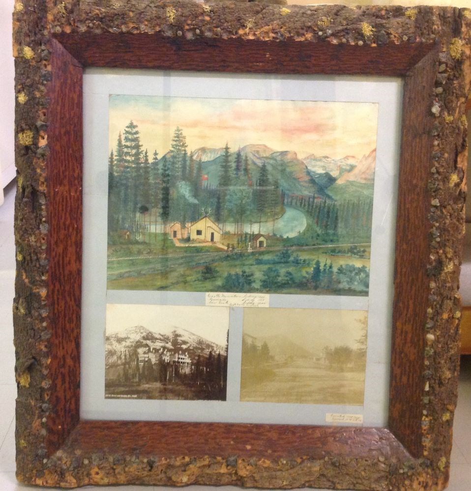
Castle Mountain Siding
https://archives.whyte.org/en/permalink/artifactzoc.13.01
- Artist
- C. Zollern
- Date
- 1895
- Medium
- watercolour; photograph on paper
- Catalogue Number
- ZoC.13.01
- Description
- Colour: green, yellow. Three frames inside one. Top picture is a painting of a group of wooden buildings left of center with a flag pole (flag is flying) and antlers on the roof. In front are railway tracks with a team of four workers going along on a cart. Behind is a river with a man fishing in i…
1 image
- Artist
- C. Zollern
- Title
- Castle Mountain Siding
- Date
- 1895
- Medium
- watercolour; photograph on paper
- Dimensions
- 34.8 x 47.5 cm
- Description
- Colour: green, yellow. Three frames inside one. Top picture is a painting of a group of wooden buildings left of center with a flag pole (flag is flying) and antlers on the roof. In front are railway tracks with a team of four workers going along on a cart. Behind is a river with a man fishing in it on the right. On both sides of the river are trees and in the distance are mountains. Sky fills the top. The lower two pictures are photographs. The left is of the first Banff Springs Hotel and Rundle Mountain. The right is looking down the main street of Banff in 1895.
- Credit
- Gift of Catharine Robb Whyte, O. C., Banff, 1974
- Catalogue Number
- ZoC.13.01
Images
This material is presented as originally created; it may contain outdated cultural descriptions and
potentially offensive content.
Read more.
Drawing of Rocky Mountain by J.L.*
https://archives.whyte.org/en/permalink/catalogue21324
- Medium
- Library - Maps and blueprints (unannotated; published)
- Map
- Published Date
- 1873
- Call Number
- C4-5.2
- Published Date
- 1873
- Subjects
- Rocky Mountain House
- Notes
- Photostatic copy from Public Archives * See The Cairn, vol III, no. 2 last page re: Jean L'Heureux by E.J. Hart
- * See: The Cairn, vol III, no. 2 last page re: Jean L'Hereux by E.J. Hart
- Accession Number
- 675
- Call Number
- C4-5.2
- Collection
- Archives Library
This material is presented as originally created; it may contain outdated cultural descriptions and
potentially offensive content.
Read more.
Topographical sheet
https://archives.whyte.org/en/permalink/catalogue24646
- Medium
- Library - Maps and blueprints (unannotated; published)
- Map
- Published Date
- 1890
- Publisher
- Dept. of the Interior
- Call Number
- C3-8.6
- Publisher
- Dept. of the Interior
- Published Date
- 1890
- Scale
- Scale: 1:40,000
- Relief: Contour interval 100 ft.
- Subjects
- Castle Mountain
- Notes
- Photostatic copy from Public Archives
- Accession Number
- 675
- Call Number
- C3-8.6
- Collection
- Archives Library
This material is presented as originally created; it may contain outdated cultural descriptions and
potentially offensive content.
Read more.
Topographical sheet
https://archives.whyte.org/en/permalink/catalogue24648
- Medium
- Library - Maps and blueprints (unannotated; published)
- Map
- Published Date
- 1890
- Publisher
- Dept. of the Interior
- Call Number
- C3-8.8
- Publisher
- Dept. of the Interior
- Published Date
- 1890
- Scale
- Scale: 1:40,000
- Relief: Contour interval 100 ft.
- Subjects
- Cascade Mountain
- Notes
- Photostatic copy from Public Archives
- Accession Number
- 675
- Call Number
- C3-8.8
- Collection
- Archives Library
This material is presented as originally created; it may contain outdated cultural descriptions and
potentially offensive content.
Read more.
Topographical sheet
https://archives.whyte.org/en/permalink/catalogue24651
- Medium
- Library - Maps and blueprints (unannotated; published)
- Map
- Published Date
- 1892
- Publisher
- Dept. of the Interior
- Call Number
- C3-8.11
- Publisher
- Dept. of the Interior
- Published Date
- 1892
- Scale
- Scale: 1:40,000
- Relief: Contour interval 100 ft.
- Subjects
- Copper Mountain
- Notes
- Photostatic copy from Public Archives
- Accession Number
- 675
- Call Number
- C3-8.11
- Collection
- Archives Library
This material is presented as originally created; it may contain outdated cultural descriptions and
potentially offensive content.
Read more.
Topographical sheet
https://archives.whyte.org/en/permalink/catalogue24656
- Medium
- Library - Maps and blueprints (unannotated; published)
- Map
- Published Date
- 1891
- Publisher
- Dept. of the Interior
- Call Number
- C3-8.16
- Publisher
- Dept. of the Interior
- Published Date
- 1891
- Scale
- Scale: 1:40,000
- Relief: Contour interval 100 ft.
- Subjects
- End Mountain
- Notes
- Photostatic copy from Public Archives
- Accession Number
- 675
- Call Number
- C3-8.16
- Collection
- Archives Library
This material is presented as originally created; it may contain outdated cultural descriptions and
potentially offensive content.
Read more.
Topographical sheets
https://archives.whyte.org/en/permalink/catalogue24652
- Medium
- Library - Maps and blueprints (unannotated; published)
- Map
- Published Date
- 1892
- Publisher
- Dept. of the Interior
- Call Number
- C3-8.12
- Publisher
- Dept. of the Interior
- Published Date
- 1892
- Scale
- Scale: 1: 40,000
- Relief: Contour interval 100 ft.
- Subjects
- Pilot Mountain
- Notes
- Photostatic copy from Public Archives
- Accession Number
- 675
- Call Number
- C3-8.12
- Collection
- Archives Library
This material is presented as originally created; it may contain outdated cultural descriptions and
potentially offensive content.
Read more.