Narrow Results By
- Part Of
- Peter and Catharine Whyte fonds
- Scope & Content
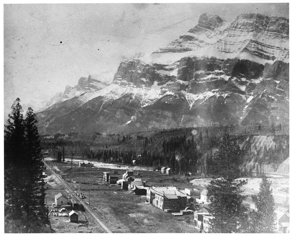
- Image of structures along a railway line, Rundle Mountain in the background
- Date Range
- [ca. 1889-1920]
- Reference Code
- V683 / III / A / 3 / PA - 258
- Description Level
- 6 / Item
- GMD
- Photograph
1 image
- Part Of
- Peter and Catharine Whyte fonds
- Description Level
- 6 / Item
- Fonds Number
- M36 / V683 / S37
- Series
- V683 / III / A / 3 : Peter and Catharine Whyte: Various Views of Banff and Area
- Sous-Fonds
- V683
- Accession Number
- .
- Reference Code
- V683 / III / A / 3 / PA - 258
- GMD
- Photograph
- Date Range
- [ca. 1889-1920]
- Physical Description
- Photograph: 1 print ; b&w.
- Scope & Content
- Image of structures along a railway line, Rundle Mountain in the background
- Subject Access
- Buildings
- Rundle Mountain
- Trains
- Geographic Access
- Anthracite
- Bankhead
- Language
- English
- Title Source
- Title based on item
- Processing Status
- Processed
Images
This material is presented as originally created; it may contain outdated cultural descriptions and
potentially offensive content.
Read more.
- Part Of
- Peter and Catharine Whyte fonds
- Scope & Content
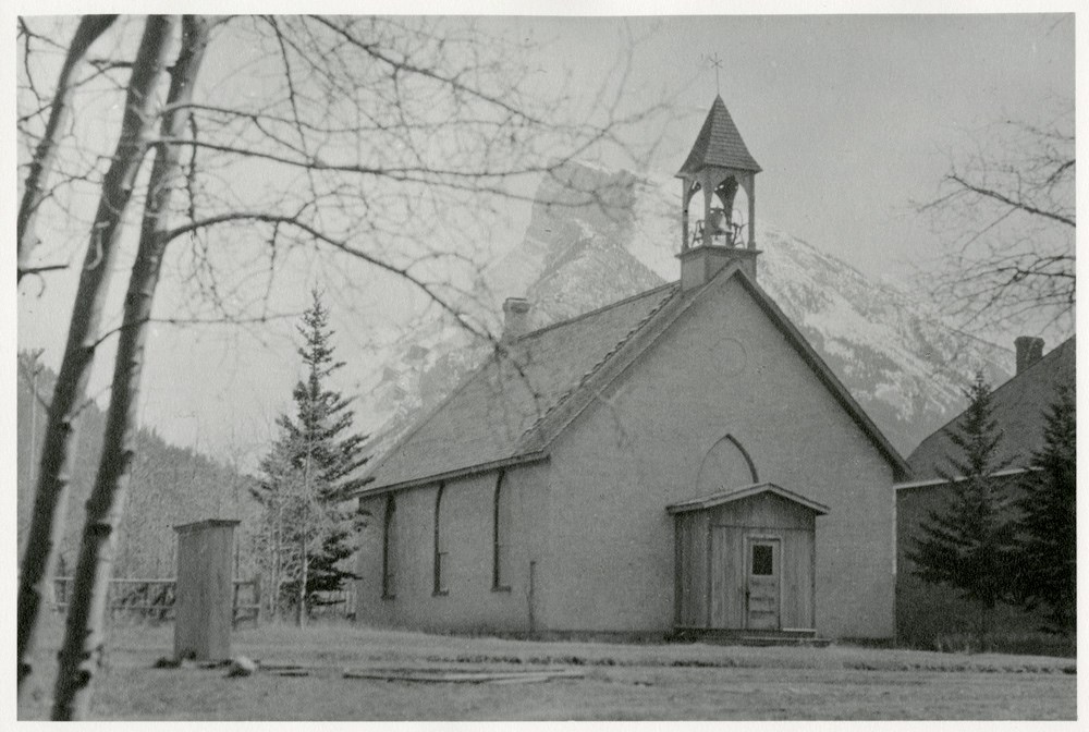
- Image of a church with a bell tower - possibly St. Geroge-in-the-Pines Anglican Church - with Rundle Mountain in the distance
- Date Range
- [ca. 1920-1940]
- Reference Code
- V683 / III / A / 5 / PA - 258
- Description Level
- 6 / Image
- GMD
- Photograph
1 image
- Part Of
- Peter and Catharine Whyte fonds
- Description Level
- 6 / Image
- Fonds Number
- M36 / V683 / S37
- Series
- V683 / III / A / 5 : Peter and Catharine Whyte: Landscapes
- Sous-Fonds
- V683
- Accession Number
- .
- Reference Code
- V683 / III / A / 5 / PA - 258
- GMD
- Photograph
- Date Range
- [ca. 1920-1940]
- Physical Description
- Photograph: 1 print ; b&w.
- Scope & Content
- Image of a church with a bell tower - possibly St. Geroge-in-the-Pines Anglican Church - with Rundle Mountain in the distance
- Geographic Access
- Banff
- Language
- English
- Title Source
- Title based on item
- Processing Status
- Processed
Images
This material is presented as originally created; it may contain outdated cultural descriptions and
potentially offensive content.
Read more.
East End of Rundle (EEOR) / Mount Rundle Summit Registers and Notes
https://archives.whyte.org/en/permalink/descriptions57665
- Part Of
- Alpine Club of Canada fonds
- Scope & Content
- Files consist of summit notes and summit registers from East End of Rundle and Mount Rundle produced by the Alpine Club of Canada between around 2001 to 2017. Summit records include entries from visitors to the various summits which pertain to individuals' hiking and climbing trips; details of spec…
- Date Range
- ca. 2001-2002
- 2014-2017
- Reference Code
- M200 / V / A / 26 to 29
- Description Level
- 5 / File
- GMD
- Textual record
- Organization record
- Part Of
- Alpine Club of Canada fonds
- Description Level
- 5 / File
- Fonds Number
- M200
- V14
- S6
- Series
- M200 / V: Summit Records
- Sous-Fonds
- M200
- Sub-Series
- M200 / V / A: Identified Summit Records
- Accession Number
- accn. 8119
- accn. 7779
- accn. 2023.20
- accn. 2023.32
- Reference Code
- M200 / V / A / 26 to 29
- Responsibility
- Summit Registers and Notes produced by Alpine Club of Canada
- Date Range
- ca. 2001-2002
- 2014-2017
- Physical Description
- 4 volumes 7 cm of textual records
- History / Biographical
- The East End of Rundle is part of the eastern ridge of Mount Rundle near Canmore, AB. From the summit, views of Ha Ling Peak and Spray Valley can be seen.
- Scope & Content
- Files consist of summit notes and summit registers from East End of Rundle and Mount Rundle produced by the Alpine Club of Canada between around 2001 to 2017. Summit records include entries from visitors to the various summits which pertain to individuals' hiking and climbing trips; details of specific events which occurred while at the summit, wildlife sightings, trail updates, and related topics. Files include: M200 / V / A / 26: Mt. Rundle Register [ca. 2001] M200 / V / A / 27: Mount Rundle East June 2002 - Sep 2002 M200 / V / A / 28: EEOR Summit Register [ca. 2014 - 2015] M200 / V / A / 29: East End of Rundle Summit Log [2016-2017]
- Name Access
- Alpine Club of Canada
- Subject Access
- Alpine Club of Canada
- Backcountry skiing
- Backpacking
- Banff
- Bow Valley
- Climbing
- Club
- Environment and Nature
- Environment
- Hiking
- Kananaskis Country
- Mountain
- Mountaineering
- Mountaineers
- Mountains
- Provincial parks and reserves
- Rundle Mountain
- Sports and leisure
- Sports and recreation
- Summit
- Trails
- Winter sports
- Geographic Access
- Canada
- Alberta
- Bow Valley
- Canmore
- Banff
- Banff National Park
- Grassi Lake
- Kananaskis Country
- Mount Rundle
- Rocky Mountains
- Rundle Mountain
- Spray Lakes
- Access Restrictions
- Restrictions may apply
- Language
- English
- French
- Mandarin
- Japanese
- Spanish
- Conservation
- Some registers have water damage and rust damage.
- Related Material
- M235
- Biographical Source Notes
- All Trails East End of Rundle (EEOR) https://www.alltrails.com/trail/canada/alberta/east-end-of-rundle-eeor
- Title Source
- Title based on contents of file
- Processing Status
- Processed
This material is presented as originally created; it may contain outdated cultural descriptions and
potentially offensive content.
Read more.
- Part Of
- Peter and Catharine Whyte fonds
- Scope & Content
- Image of Echo Creek in winter with Rundle Mountain in the distance
- Date Range
- [ca. 1920-1940]
- Reference Code
- V683 / III / A / 5 / PA - 46
- Description Level
- 6 / Image
- GMD
- Photograph
1 image
- Part Of
- Peter and Catharine Whyte fonds
- Description Level
- 6 / Image
- Fonds Number
- M36 / V683 / S37
- Series
- V683 / III / A / 5 : Peter and Catharine Whyte: Landscapes
- Sous-Fonds
- V683
- Accession Number
- .
- Reference Code
- V683 / III / A / 5 / PA - 46
- GMD
- Photograph
- Date Range
- [ca. 1920-1940]
- Physical Description
- Photographs: 1 print; b&w.
- Scope & Content
- Image of Echo Creek in winter with Rundle Mountain in the distance
- Subject Access
- Echo Creek
- Mountains
- Rivers
- Rundle Mountain
- Winter
- Geographic Access
- Banff National Park
- Language
- English
- Title Source
- Title based on item
- Processing Status
- Processed
Images

This material is presented as originally created; it may contain outdated cultural descriptions and
potentially offensive content.
Read more.
Lake Minnewanka
https://archives.whyte.org/en/permalink/descriptions52462
- Part Of
- Peter and Catharine Whyte fonds
- Scope & Content
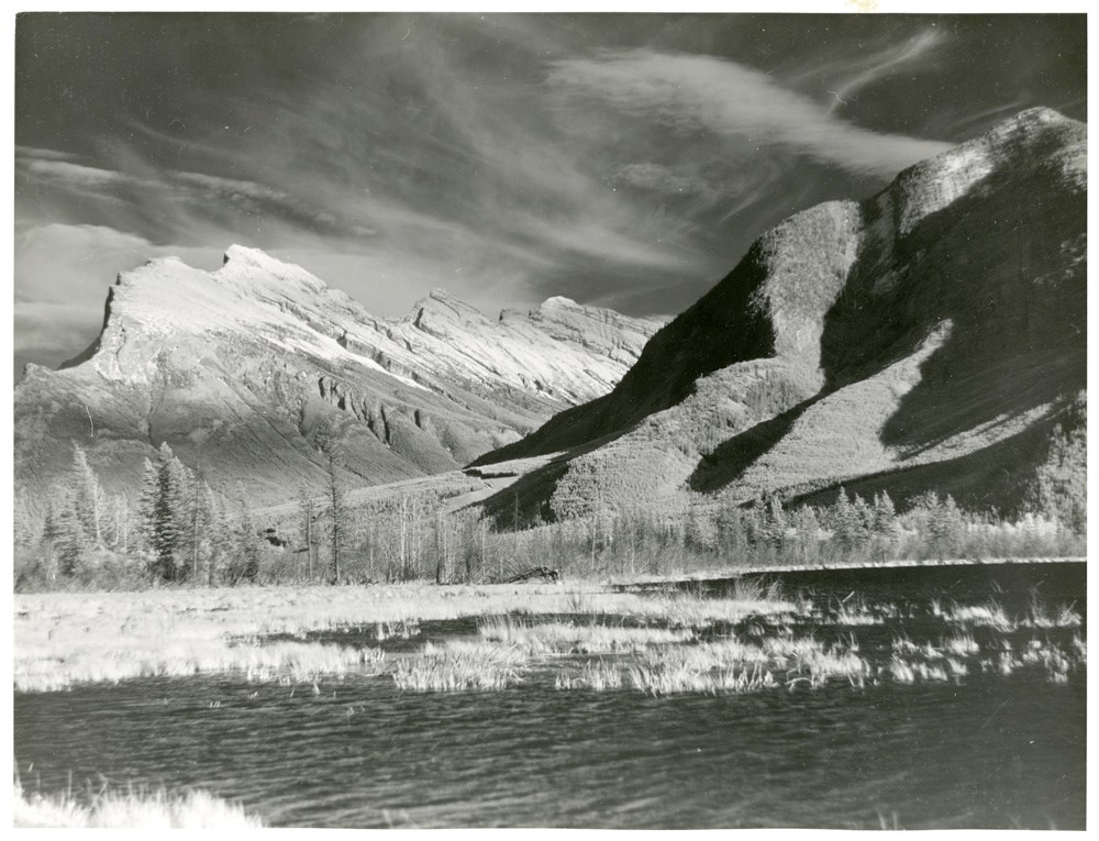
- Image of Lake Minnewanka looking south towards Rundle Mountain - logs in foreground
- Date Range
- [ca. 1920-1940]
- Reference Code
- V683 / III / A / 5 / PA - 44
- Description Level
- 6 / Image
- GMD
- Photograph
1 image
- Part Of
- Peter and Catharine Whyte fonds
- Description Level
- 6 / Image
- Fonds Number
- M36 / V683 / S37
- Series
- V683 / III / A / 5 : Peter and Catharine Whyte: Landscapes
- Sous-Fonds
- V683
- Accession Number
- .
- Reference Code
- V683 / III / A / 5 / PA - 44
- GMD
- Photograph
- Date Range
- [ca. 1920-1940]
- Physical Description
- Photographs: 1 print; b&w.
- Scope & Content
- Image of Lake Minnewanka looking south towards Rundle Mountain - logs in foreground
- Subject Access
- Lake Minnewanka
- Mountains
- Rundle Mountain
- Geographic Access
- Banff National Park
- Language
- English
- Title Source
- Title based on item
- Processing Status
- Processed
Images

This material is presented as originally created; it may contain outdated cultural descriptions and
potentially offensive content.
Read more.
- Date
- 2009
- Medium
- painting on paper
- Catalogue Number
- SmB.05.05
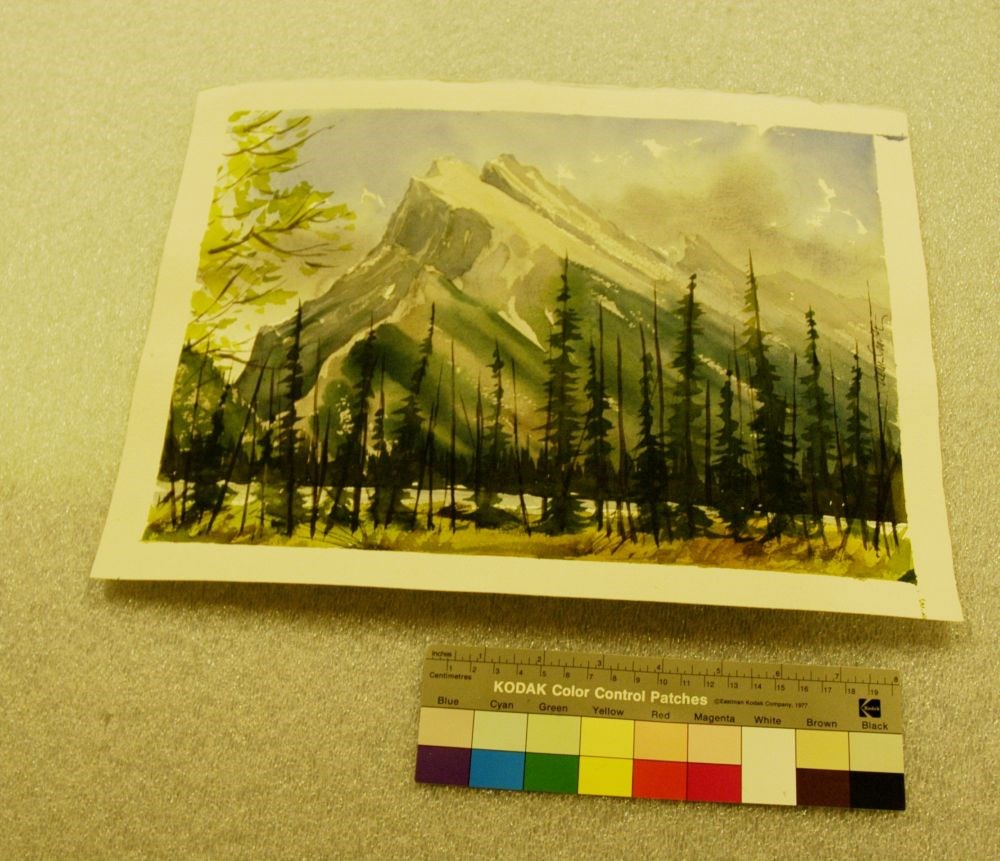
- Description
- A summer scene dominated by Mt. Rundle and the trees that flank Vermilion’s first lake. The dominant colours are light and dark green, black, blue, brown and grey. The foreground is green and brown low vegetation, out of which a line of lodgepole pines, some dead and still standing, rise to two-thi…
1 image
- Title
- Rundle
- Date
- 2009
- Medium
- painting on paper
- Dimensions
- 29.0 x 38.5 cm
- Description
- A summer scene dominated by Mt. Rundle and the trees that flank Vermilion’s first lake. The dominant colours are light and dark green, black, blue, brown and grey. The foreground is green and brown low vegetation, out of which a line of lodgepole pines, some dead and still standing, rise to two-thirds of the painting. Starting at the viewer’s far left, at mid-point, the branches of an aspen with green leaves fills the top far left of the painting. Vermilion’s first lake is visible though the lodgepoles and directly behind that, are the dark trees that line its opposite bank. Above the lake the lower slope of Tunnel Mountain is visible to the viewer’s left. The painting is dominated by majestic Mount Rundle, its lower slopes covered with muted green coniferous trees and its sheer rock face in varying shades of grey, blue, and brown. The deep blue sky has a few wisps of white showing through and some light grey clouds to the viewer’s right, above the peaks of the Rundle Range.
- Credit
- Purchased from Brett Smith, 108 Mile Ranch, 2009
- Catalogue Number
- SmB.05.05
Images
This material is presented as originally created; it may contain outdated cultural descriptions and
potentially offensive content.
Read more.
Rundle and Sulphur Mountains from Vermillion Lakes
https://archives.whyte.org/en/permalink/descriptions51633
- Part Of
- Peter and Catharine Whyte fonds
- Scope & Content
- Image of Rundle and Sulphur Mountains from the first Vermillion Lake
- Date Range
- [ca. 1920-1940]
- Reference Code
- V683 / III / A / 5 / PA - 262
- Description Level
- 6 / Image
- GMD
- Photograph
1 image
- Part Of
- Peter and Catharine Whyte fonds
- Description Level
- 6 / Image
- Fonds Number
- M36 / V683 / S37
- Series
- V683 / III / A / 5 : Peter and Catharine Whyte: Landscapes
- Sous-Fonds
- V683
- Accession Number
- .
- Reference Code
- V683 / III / A / 5 / PA - 262
- GMD
- Photograph
- Date Range
- [ca. 1920-1940]
- Physical Description
- Photograph: 1 print ; b&w.
- Scope & Content
- Image of Rundle and Sulphur Mountains from the first Vermillion Lake
- Subject Access
- Mountains
- Rundle Mountain
- Sulphur Mountain
- Vermillion Lakes
- Geographic Access
- Banff National Park
- Language
- English
- Title Source
- Title based on item
- Processing Status
- Processed
Images
This material is presented as originally created; it may contain outdated cultural descriptions and
potentially offensive content.
Read more.
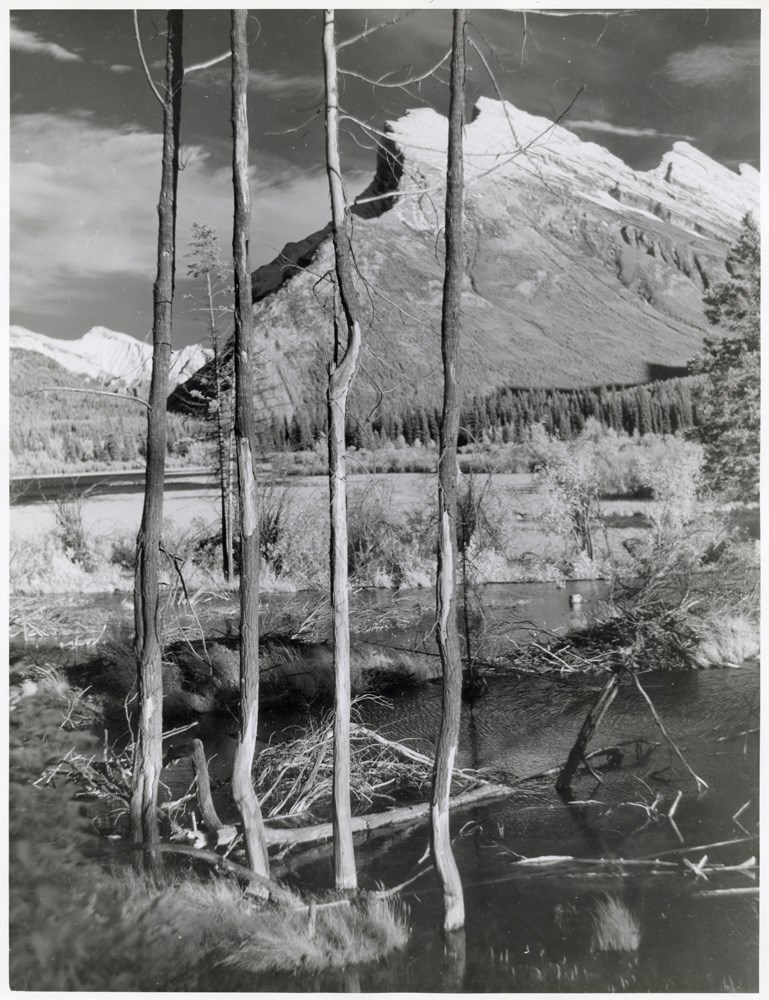
Rundle Mountain
https://archives.whyte.org/en/permalink/descriptions52789
- Part Of
- Peter and Catharine Whyte fonds
- Scope & Content
- Image of Rundle Mountain from Vermillion Lakes through trees
- Date Range
- [ca. 1900-1940]
- Reference Code
- V683 / III / A / 8 / PA - 659
- Description Level
- 6 / Item
- GMD
- Photograph
1 image
- Part Of
- Peter and Catharine Whyte fonds
- Description Level
- 6 / Item
- Fonds Number
- M36 / V683 / S37
- Series
- V683 / III / A / 8 : Peter and Catharine Whyte: Banff and Area Skiing
- Sous-Fonds
- V683
- Accession Number
- .
- Reference Code
- V683 / III / A / 8 / PA - 659
- GMD
- Photograph
- Date Range
- [ca. 1900-1940]
- Physical Description
- Photograph: 1 print; b&w.
- Scope & Content
- Image of Rundle Mountain from Vermillion Lakes through trees
- Subject Access
- Mountains
- Rundle Mountain
- Vermillion Lakes
- Geographic Access
- Banff National Park
- Language
- English
- Title Source
- Title based on item
- Processing Status
- Processed
Images
This material is presented as originally created; it may contain outdated cultural descriptions and
potentially offensive content.
Read more.
Rundle Mountain
https://archives.whyte.org/en/permalink/descriptions50100
- Part Of
- Peter and Catharine Whyte fonds
- Scope & Content
- Image of Rundle Mountain with [possibly] 40 Mile Creek in the foreground - covered in snow
- Date Range
- [ca. 1920-1940]
- Reference Code
- V683 / III / A / 5 / PA - 257
- Description Level
- 6 / Image
- GMD
- Photograph
1 image
- Part Of
- Peter and Catharine Whyte fonds
- Description Level
- 6 / Image
- Fonds Number
- M36 / V683 / S37
- Series
- V683 / III / A / 5 : Peter and Catharine Whyte: Landscapes
- Sous-Fonds
- V683
- Accession Number
- .
- Reference Code
- V683 / III / A / 5 / PA - 257
- GMD
- Photograph
- Date Range
- [ca. 1920-1940]
- Physical Description
- Photograph: 1 print ; b&w.
- Scope & Content
- Image of Rundle Mountain with [possibly] 40 Mile Creek in the foreground - covered in snow
- Subject Access
- Forty Mile Creek
- Rundle Mountain
- Winter
- Geographic Access
- Banff National Park
- Language
- English
- Title Source
- Title based on item
- Processing Status
- Processed
Images

This material is presented as originally created; it may contain outdated cultural descriptions and
potentially offensive content.
Read more.
Rundle Mountain and stream in winter
https://archives.whyte.org/en/permalink/descriptions51628
- Part Of
- Peter and Catharine Whyte fonds
- Scope & Content
- Image of Rundle Mountain with a stream [possibly 40 Mile Creek] in winter
- Date Range
- [ca. 1920-1940]
- Reference Code
- V683 / III / A / 5 / PA - 257
- Description Level
- 6 / Image
- GMD
- Photograph
1 image
- Part Of
- Peter and Catharine Whyte fonds
- Description Level
- 6 / Image
- Fonds Number
- M36 / V683 / S37
- Series
- V683 / III / A / 5 : Peter and Catharine Whyte: Landscapes
- Sous-Fonds
- V683
- Accession Number
- .
- Reference Code
- V683 / III / A / 5 / PA - 257
- GMD
- Photograph
- Date Range
- [ca. 1920-1940]
- Physical Description
- Photograph: 1 print ; b&w.
- Scope & Content
- Image of Rundle Mountain with a stream [possibly 40 Mile Creek] in winter
- Subject Access
- Mountains
- Rivers
- Rundle Mountain
- Winter
- Geographic Access
- Banff National Park
- Language
- English
- Title Source
- Title based on item
- Processing Status
- Processed
Images
This material is presented as originally created; it may contain outdated cultural descriptions and
potentially offensive content.
Read more.