Narrow Results By
Surveying the 120th meridian and the great divide : the Alberta/BC boundary survey, 1918-1924
https://archives.whyte.org/en/permalink/catalogue24952
- Medium
- Library - Book (including soft-cover and pamphlets)
- Published Date
- 2019
- Author
- Sherwood, Jay
- Publisher
- Halfmoon Bay, BC : Caitlin Press
- Call Number
- 08.3 Sh5s Volume 2
1 website
- Author
- Sherwood, Jay
- Responsibility
- Jay Sherwood
- Publisher
- Halfmoon Bay, BC : Caitlin Press
- Published Date
- 2019
- Physical Description
- 192 p. ; illus.
- Series
- Volume 2
- Subjects
- Surveyors
- Surveys and Mapping
- Surveys
- Great Divide Trail
- Alberta
- British Columbia
- British Columbia - Boundaries
- British Columbia - Surveys and Mapping
- Alberta - B.C. Boundary
- Alberta - Boundaries
- Wheeler, Arthur Oliver
- Cautley, Richard William
- History
- History of Alberta
- Abstract
- "Surveying the 120th Meridian and the Great Divide is the second book of a two-part series describing the initial Alberta/BC boundary survey undertaken between 1913-1924. Surveying the 120th Meridian focuses on the years 1918–1924, when the Alberta crew continued the survey of the 120th meridian while the BC crew split off to continue mapping the Great (Continental) Divide. The Alberta/BC boundary survey was a unique Canadian project that combined talented surveyors, high-tech surveying equipment, rugged crew members and Canadian wilderness. This is a story of adventure and danger: the crew climbed mountains and surveyed from the peaks of the Canadian Rockies; slogged through the muskeg north of the Peace River; occasionally crossed rivers at high water; and often worked in the rain, snow or cold. The boundary survey produced the first detailed maps of the terrain along the divide and the first pictures of the northern Canadian Rockies taken from an airplane. But the most important legacy of this project is the collection of approximately 5,000 photographs developed from high-quality glass plate negatives. These photographs provide full panoramas of the Rocky Mountain landscape as it looked over a century ago. Surveying the 120th Meridian and the Great Divide combines the best of these photographs, diary entries and government documents to recount the astonishing journey of the surveyors and their crew members as they explored Canada’s most dramatic landscape."-- Provided by publisher.
- Contents
- Maps
- Acknowledgements
- Introduction
- The Surveyors
- Surveying Methods 1918-1924
- Completion of the Boundary Survey, 1950-1953
- Conclusion
- Geographical Names
- Survey Crews, 1918-1924
- Sources Consulted
- Index
- Notes
- Features visual and textual material from the A.O. Wheeler fonds M546 / V771
- ISBN
- 9780773860091
- Accession Number
- 2019.90
- Call Number
- 08.3 Sh5s Volume 2
- Collection
- Archives Library
- URL Notes
- Publisher's website
Websites
This material is presented as originally created; it may contain outdated cultural descriptions and
potentially offensive content.
Read more.

Railways in southern Alberta
https://archives.whyte.org/en/permalink/catalogue20076
- Medium
- Library - Book (including soft-cover and pamphlets)
- Published Date
- 1973
- Author
- Bowman, R.F.P.
- Publisher
- Lethbridge, Alta. : Lethbridge Historical Society
- Call Number
- 08.2 B67r Pam
- Author
- Bowman, R.F.P.
- Responsibility
- R.F.P. Bowman
- Publisher
- Lethbridge, Alta. : Lethbridge Historical Society
- Published Date
- 1973
- Physical Description
- 40 p. : ill., map, ports. ; 28 cm.
- Abstract
- Pertains to the history of the southern Alberta railways, written as a labor of love from Lethbridge local, R.F.P. Bowman. The intent of the publication was to record the history of the early local railway, in an effort to preserve the history before it was to be forgotten. Author R.F.P. Bowman, worked to commemorate the events that were able to elevate the area of Lethbridge, Alberta from its infancy into a state of maturity.
- Contents
- Chapter I: The beginnings (pg. 7)
- Chapter II: The Galts (pg. 9)
- Chapter III: Enter Canadian Pacific (pg. 13)
- Chapter IV: The Canadian Pacific extends (pg. 24)
- Chapter V: Other efforts (pg. 27)
- Chapter VI: Passenger trains in the past tense (pg. 31)
- Chapter VII: Freight - the railway's main diet (pg. 34)
- Chapter VIII: The Lethbridge division (pg. 38)
- Accession Number
- 3069 a
- Call Number
- 08.2 B67r Pam
- Collection
- Archives Library
This material is presented as originally created; it may contain outdated cultural descriptions and
potentially offensive content.
Read more.
Alberta art : exhibition of art works from the collection of the Alberta Art Foundation
https://archives.whyte.org/en/permalink/catalogue20384
- Medium
- Library - Book (including soft-cover and pamphlets)
- Published Date
- [1979?]
- Publisher
- [Edmonton?] : The Foundation
- Call Number
- N6546 A4 A4
- Publisher
- [Edmonton?] : The Foundation
- Published Date
- [1979?]
- Physical Description
- 98p. : ill.
- Subjects
- Art - Alberta
- Artists - Alberta
- Glyde, H.G. (Henry George)
- Barry, Douglas
- May, Margaret
- Nicoll, Marion
- Tanabe, Takao
- Janvier, Alex
- Mitchell, Janet
- Snow, John
- Bates, Maxwell
- Notes
- Catalogue of an exhibition circulated in Japan (1979?)
- Text in English, French, and Japanese
- Call Number
- N6546 A4 A4
- Location
- Art Library is located in Curatorial Department - Please contact Curatorial Department for access
- Collection
- Art Library
This material is presented as originally created; it may contain outdated cultural descriptions and
potentially offensive content.
Read more.
[Alberta Municipalities]
https://archives.whyte.org/en/permalink/catalogue24447
- Medium
- Library - Maps and blueprints (unannotated; published)
- Map
- Published Date
- 1975
- Publisher
- Surveys Branch Alberta Transp.
- Call Number
- C9-5.14(b)
- Publisher
- Surveys Branch Alberta Transp.
- Published Date
- 1975
- Scale
- Scale: 1":40 miles
- Subjects
- Alberta
- Alberta Municipalities
- Notes
- Colour: Rocky Mtn Forest Reserve
- Accession Number
- SG9000
- Call Number
- C9-5.14(b)
- Collection
- Archives Library
This material is presented as originally created; it may contain outdated cultural descriptions and
potentially offensive content.
Read more.
[Alberta Municipalities, Department of Municipal Affairs]
https://archives.whyte.org/en/permalink/catalogue24446
- Medium
- Library - Maps and blueprints (unannotated; published)
- Map
- Published Date
- 1974
- Publisher
- Surveys Branch, Department of Highways and Transport
- Call Number
- C9-5.14(a)
- Publisher
- Surveys Branch, Department of Highways and Transport
- Published Date
- 1974
- Physical Description
- 2 sections; 1 map : col
- Scale
- Scale: 1:750,000
- Accession Number
- SG7500
- Call Number
- C9-5.14(a)
- Collection
- Archives Library
This material is presented as originally created; it may contain outdated cultural descriptions and
potentially offensive content.
Read more.
[Alberta municipalities] Map showing Alberta Municipalities. Rocky Mountains Forest Reserve, Metis Colonies
https://archives.whyte.org/en/permalink/catalogue24448
- Medium
- Library - Maps and blueprints (unannotated; published)
- Map
- Published Date
- 1977
- Call Number
- C9-5.14(c)
- Published Date
- 1977
- Scale
- Scale: 1":40 miles
- Subjects
- Alberta
- Alberta Municipalities
- Accession Number
- 11,500
- Call Number
- C9-5.14(c)
- Collection
- Archives Library
This material is presented as originally created; it may contain outdated cultural descriptions and
potentially offensive content.
Read more.
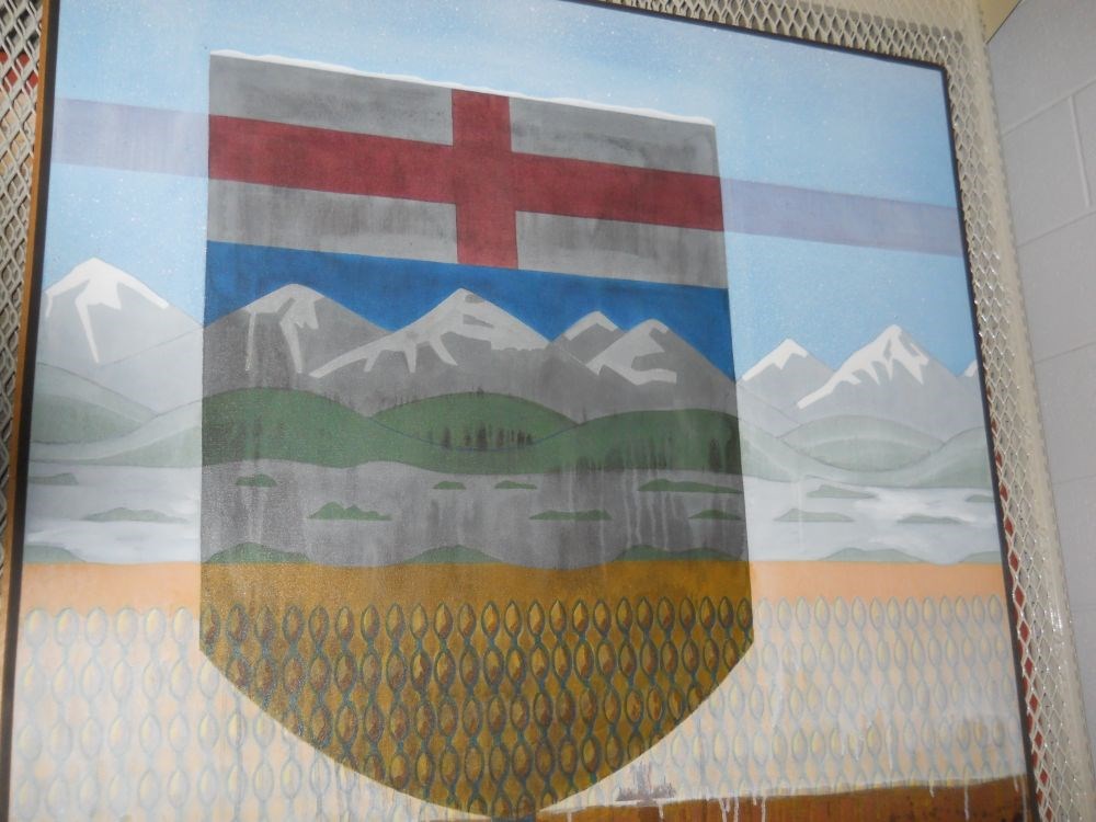
Alberta: Snow and Tar Sands
https://archives.whyte.org/en/permalink/artifactans.02.01
- Date
- 1977
- Medium
- oil on canvas
- Catalogue Number
- AnS.02.01
- Description
- Alberta flag emblem and rolling foothills and wheat fields. Opaque white paint drips close to bottom edge of painting.
1 image
- Title
- Alberta: Snow and Tar Sands
- Date
- 1977
- Medium
- oil on canvas
- Dimensions
- 121.5 x 123.0 cm
- Description
- Alberta flag emblem and rolling foothills and wheat fields. Opaque white paint drips close to bottom edge of painting.
- Credit
- Gift of Stephen Andrews, Banff, 1977
- Catalogue Number
- AnS.02.01
Images
This material is presented as originally created; it may contain outdated cultural descriptions and
potentially offensive content.
Read more.
[Alberta-Population] By Townships and Incorporated Places, 1971 Census of CAnada
https://archives.whyte.org/en/permalink/catalogue24426
- Medium
- Library - Maps and blueprints (unannotated; published)
- Map
- Published Date
- 1971
- Publisher
- Surveys Branch, Department of Highways and Transport
- Call Number
- C9-5.2(c)
- Publisher
- Surveys Branch, Department of Highways and Transport
- Published Date
- 1971
- Physical Description
- 1 map : black and white (census in red)
- Scale
- Scale: 12 miles: 1 inch
- Subjects
- Alberta
- Alberta-Population
- Accession Number
- SG7500
- Call Number
- C9-5.2(c)
- Collection
- Archives Library
This material is presented as originally created; it may contain outdated cultural descriptions and
potentially offensive content.
Read more.
[Alberta-Population] Census Divisions
https://archives.whyte.org/en/permalink/catalogue24428
- Medium
- Library - Maps and blueprints (unannotated; published)
- Map
- Published Date
- 1970
- Publisher
- Surveys Branch, Department of Highways and Transport
- Call Number
- C9-5.2(e)
- Publisher
- Surveys Branch, Department of Highways and Transport
- Published Date
- 1970
- Scale
- Scale: 1":40 miles
- Subjects
- Alberta
- Alberta-Population
- Notes
- Census area coloured
- Accession Number
- SG7500
- Call Number
- C9-5.2(e)
- Collection
- Archives Library
This material is presented as originally created; it may contain outdated cultural descriptions and
potentially offensive content.
Read more.
[Alberta-Population, Census Divisions]
https://archives.whyte.org/en/permalink/catalogue24429
- Medium
- Library - Maps and blueprints (unannotated; published)
- Map
- Published Date
- 1975
- Publisher
- Surveys Branch Alberta Transp.
- Call Number
- C9-5.2(f)
- Publisher
- Surveys Branch Alberta Transp.
- Published Date
- 1975
- Scale
- Scale: 1":40 miles
- Subjects
- Alberta
- Alberta-Population
- Census Divisions
- Notes
- Coloured areas denote census divisions
- Accession Number
- SG9000
- Call Number
- C9-5.2(f)
- Collection
- Archives Library
This material is presented as originally created; it may contain outdated cultural descriptions and
potentially offensive content.
Read more.