Narrow Results By
- Organization record 32
- Textual record 32
- Library - Book (including soft-cover and pamphlets) 30
- Library - Periodical 18
- Digital Chromogenic Colour Print Photograph
- Library - Maps and blueprints (unannotated; published)
- Map 4
- Archival Inkjet Print Photograph 1
- Library - Moving image (includes film and digital video - published) 1
Map of the Kootenay region to accompany report of Supt. S.B. Steele comanding the detachment of Mounted Police in B.C.
https://archives.whyte.org/en/permalink/catalogue21416
- Medium
- Library - Maps and blueprints (unannotated; published)
- Map
- Published Date
- 1888
- Call Number
- C10-6.2
- Published Date
- 1888
- Subjects
- Central British Columbia
- Notes
- Photostatic copy from Public Archives
- Accession Number
- 675
- Call Number
- C10-6.2
- Collection
- Archives Library
This material is presented as originally created; it may contain outdated cultural descriptions and
potentially offensive content.
Read more.
Map shewing the Distribution of the Indian Tribes of British Columbia by W.F. Tolmie and G.M. Dawson
https://archives.whyte.org/en/permalink/catalogue21365
- Medium
- Library - Maps and blueprints (unannotated; published)
- Map
- Published Date
- 1883
- Publisher
- Geological and Natural History Survey of Canada
- Call Number
- C6-10.2(a)
- Responsibility
- W.F. Tolmie and G.M. Dawson
- Publisher
- Geological and Natural History Survey of Canada
- Published Date
- 1883
- Subjects
- Indian Tribes of British Columbia
- Notes
- Accompanies "Comparative Vocabularies of the Indian Tribes of B.C."
- Accession Number
- 400
- Call Number
- C6-10.2(a)
- Collection
- Archives Library
This material is presented as originally created; it may contain outdated cultural descriptions and
potentially offensive content.
Read more.
Map shewing the Distribution of the Indian Tribes of British Columbia by W.F. Tolmie and G.M. Dawson
https://archives.whyte.org/en/permalink/catalogue21395
- Medium
- Library - Maps and blueprints (unannotated; published)
- Map
- Published Date
- 1883
- Publisher
- Geological and Natural History Survey of Canada
- Call Number
- C6-10.2(a)
- Responsibility
- W.F. Tolmie and G.M. Dawson
- Publisher
- Geological and Natural History Survey of Canada
- Published Date
- 1883
- Subjects
- Indian Tribes of British Columbia
- Notes
- Accompanies "Comparative Vocabularies of the Indian Tribes of B.C."
- Accession Number
- 400
- Call Number
- C6-10.2(a)
- Collection
- Archives Library
This material is presented as originally created; it may contain outdated cultural descriptions and
potentially offensive content.
Read more.
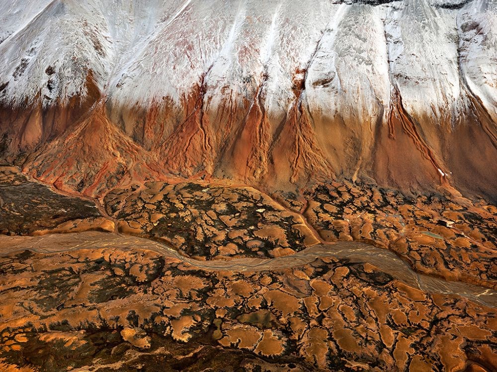
Mount Edziza #2
https://archives.whyte.org/en/permalink/artifactbue.18.12
- Date
- 2012
- Medium
- photograph on board
- Catalogue Number
- BuE.18.12
1 image
- Title
- Mount Edziza #2
- Date
- 2012
- Medium
- photograph on board
- Dimensions
- 153.4 x 203.2 cm
- Subject
- water
- Mount Edziza
- mountain
- British Columbia
- Credit
- Gift of Edward Burtynsky, Toronto, 2014
- Catalogue Number
- BuE.18.12
Images
This material is presented as originally created; it may contain outdated cultural descriptions and
potentially offensive content.
Read more.
Mount Edziza #3
https://archives.whyte.org/en/permalink/artifactbue.18.13
- Date
- 2012
- Medium
- photograph on board
- Catalogue Number
- BuE.18.13
1 image
- Title
- Mount Edziza #3
- Date
- 2012
- Medium
- photograph on board
- Dimensions
- 121.9 x 162.6 cm
- Subject
- water
- Mount Edziza
- mountain
- British Columbia
- Credit
- Gift of Edward Burtynsky, Toronto, 2014
- Catalogue Number
- BuE.18.13
Images

This material is presented as originally created; it may contain outdated cultural descriptions and
potentially offensive content.
Read more.
Mount Edziza #4
https://archives.whyte.org/en/permalink/artifactbue.18.14
- Date
- 2012
- Medium
- photograph on board
- Catalogue Number
- BuE.18.14
1 image
- Title
- Mount Edziza #4
- Date
- 2012
- Medium
- photograph on board
- Dimensions
- 121.9 x 162.6 cm
- Subject
- water
- Mount Edziza
- mountain
- British Columbia
- Credit
- Gift of Edward Burtynsky, Toronto, 2014
- Catalogue Number
- BuE.18.14
Images

This material is presented as originally created; it may contain outdated cultural descriptions and
potentially offensive content.
Read more.
[Province of British Columbia]
https://archives.whyte.org/en/permalink/catalogue24538
- Medium
- Library - Maps and blueprints (unannotated; published)
- Map
- Published Date
- 1884
- Author
- Mohun, Edward
- Call Number
- C10-10.1
- Author
- Mohun, Edward
- Published Date
- 1884
- Scale
- Scale: 1 inch - 50 miles
- Subjects
- British Columbia
- Notes
- Compiled and drawn by Edward Moun, C.E.
- Accession Number
- 440
- Call Number
- C10-10.1
- Collection
- Archives Library
This material is presented as originally created; it may contain outdated cultural descriptions and
potentially offensive content.
Read more.
- Date
- 2012
- Medium
- photograph on board
- Catalogue Number
- BuE.18.20
1 image
- Title
- Stikine River
- Date
- 2012
- Medium
- photograph on board
- Dimensions
- 121.9 x 162.6 cm
- Subject
- water
- Stikine River
- British Columbia
- Credit
- Gift of Edward Burtynsky, Toronto, 2014
- Catalogue Number
- BuE.18.20
Images

This material is presented as originally created; it may contain outdated cultural descriptions and
potentially offensive content.
Read more.