Narrow Results By
- Artist
- James Whaite
- Date
- prior to 1916
- Medium
- watercolour on paper
- Catalogue Number
- WhJ.05.01
- Description
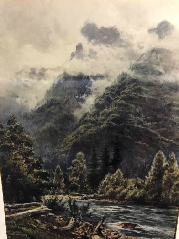
- A mountain scene, left foreground is covered with logs and rocks on grass, a river bank, running from bottom right to lower left centre is a fast flowing river, lots of foliage on trees on riverbank, mountains rise behind riverbank, tree covered, clouds on mountains tops and in the sky.
1 image
- Artist
- James Whaite
- Title
- Hope
- Date
- prior to 1916
- Medium
- watercolour on paper
- Dimensions
- 62.5 x 44.1 cm
- Description
- A mountain scene, left foreground is covered with logs and rocks on grass, a river bank, running from bottom right to lower left centre is a fast flowing river, lots of foliage on trees on riverbank, mountains rise behind riverbank, tree covered, clouds on mountains tops and in the sky.
- Subject
- landscape, mountain
- river
- forest
- Credit
- Gift of Charles C. Reid, Banff, Alberta, 1986
- Catalogue Number
- WhJ.05.01
Images
This material is presented as originally created; it may contain outdated cultural descriptions and
potentially offensive content.
Read more.
Mt. Sir Donald
https://archives.whyte.org/en/permalink/artifacthuw.05.01
- Date
- c. 1914
- Medium
- watercolour on paper
- Catalogue Number
- HuW.05.01
- Description
- A vertical painting with the bottom three quarters heavily forested with a small blue river in foreground. A pointed mountain stands to left with a flatter snow covered mountain to the right. A lightly cloudy sky top quarter.
- Title
- Mt. Sir Donald
- Date
- c. 1914
- Medium
- watercolour on paper
- Dimensions
- 26.1 x 13.3 cm
- Description
- A vertical painting with the bottom three quarters heavily forested with a small blue river in foreground. A pointed mountain stands to left with a flatter snow covered mountain to the right. A lightly cloudy sky top quarter.
- Subject
- landscape
- mountain
- Canadian Rockies
- Credit
- Gift of Dorothy Hutchinson, Winnipeg, 1994
- Catalogue Number
- HuW.05.01
This material is presented as originally created; it may contain outdated cultural descriptions and
potentially offensive content.
Read more.
Sectional map, special edition, showing lands disposed
https://archives.whyte.org/en/permalink/catalogue24596
- Medium
- Library - Maps and blueprints (unannotated; published)
- Map
- Published Date
- 1908
- Publisher
- Department of the Interior
- Call Number
- C11-6.19
- Publisher
- Department of the Interior
- Published Date
- 1908
- Scale
- 6 miles - 1 inch
- Notes
- References: Trails, Trails surveyed, Post Offices, Railway Stations, Range numbers
- Accession Number
- 400
- Call Number
- C11-6.19
- Collection
- Archives Library
This material is presented as originally created; it may contain outdated cultural descriptions and
potentially offensive content.
Read more.
Sectional map, special edition, showing lands disposed of
https://archives.whyte.org/en/permalink/catalogue24592
- Medium
- Library - Maps and blueprints (unannotated; published)
- Map
- Published Date
- 1908
- Publisher
- Department of the Interior
- Call Number
- C11-6.15
- Publisher
- Department of the Interior
- Published Date
- 1908
- Scale
- 6 miles - 1 inch
- Notes
- References: Trails, Trails surveyed, Post Offices, Railway Stations, Range numbers
- Accession Number
- 400
- Call Number
- C11-6.15
- Collection
- Archives Library
This material is presented as originally created; it may contain outdated cultural descriptions and
potentially offensive content.
Read more.
Special edition map showing lands disposed of
https://archives.whyte.org/en/permalink/catalogue24587
- Medium
- Library - Maps and blueprints (unannotated; published)
- Map
- Published Date
- 1908
- Publisher
- Dept. of the Interior
- Call Number
- C11-6.10
- Publisher
- Dept. of the Interior
- Published Date
- 1908
- Scale
- 6 miles - 1 inch
- Notes
- Sectional map
- References: Trails, Trails surveyed, Post Offices, Railway Stations, Range numbers, Township numbers...
- Accession Number
- 400
- Call Number
- C11-6.10
- Collection
- Archives Library
This material is presented as originally created; it may contain outdated cultural descriptions and
potentially offensive content.
Read more.
Special edition map showing lands disposed of
https://archives.whyte.org/en/permalink/catalogue24588
- Medium
- Library - Maps and blueprints (unannotated; published)
- Map
- Published Date
- 1908
- Publisher
- Dept. of the Interior
- Call Number
- C11-6.11
- Publisher
- Dept. of the Interior
- Published Date
- 1908
- Scale
- 6 miles - 1 inch
- Notes
- Sectional map
- References: Trails, Trails surveyed, Post Offices, Railway Stations, Range numbers, Township numbers....
- Accession Number
- 400
- Call Number
- C11-6.11
- Collection
- Archives Library
This material is presented as originally created; it may contain outdated cultural descriptions and
potentially offensive content.
Read more.
Topographical sheet
https://archives.whyte.org/en/permalink/catalogue24646
- Medium
- Library - Maps and blueprints (unannotated; published)
- Map
- Published Date
- 1890
- Publisher
- Dept. of the Interior
- Call Number
- C3-8.6
- Publisher
- Dept. of the Interior
- Published Date
- 1890
- Scale
- Scale: 1:40,000
- Relief: Contour interval 100 ft.
- Subjects
- Castle Mountain
- Notes
- Photostatic copy from Public Archives
- Accession Number
- 675
- Call Number
- C3-8.6
- Collection
- Archives Library
This material is presented as originally created; it may contain outdated cultural descriptions and
potentially offensive content.
Read more.
Topographical sheet
https://archives.whyte.org/en/permalink/catalogue24648
- Medium
- Library - Maps and blueprints (unannotated; published)
- Map
- Published Date
- 1890
- Publisher
- Dept. of the Interior
- Call Number
- C3-8.8
- Publisher
- Dept. of the Interior
- Published Date
- 1890
- Scale
- Scale: 1:40,000
- Relief: Contour interval 100 ft.
- Subjects
- Cascade Mountain
- Notes
- Photostatic copy from Public Archives
- Accession Number
- 675
- Call Number
- C3-8.8
- Collection
- Archives Library
This material is presented as originally created; it may contain outdated cultural descriptions and
potentially offensive content.
Read more.
Topographical sheet
https://archives.whyte.org/en/permalink/catalogue24651
- Medium
- Library - Maps and blueprints (unannotated; published)
- Map
- Published Date
- 1892
- Publisher
- Dept. of the Interior
- Call Number
- C3-8.11
- Publisher
- Dept. of the Interior
- Published Date
- 1892
- Scale
- Scale: 1:40,000
- Relief: Contour interval 100 ft.
- Subjects
- Copper Mountain
- Notes
- Photostatic copy from Public Archives
- Accession Number
- 675
- Call Number
- C3-8.11
- Collection
- Archives Library
This material is presented as originally created; it may contain outdated cultural descriptions and
potentially offensive content.
Read more.
Topographical sheet
https://archives.whyte.org/en/permalink/catalogue24656
- Medium
- Library - Maps and blueprints (unannotated; published)
- Map
- Published Date
- 1891
- Publisher
- Dept. of the Interior
- Call Number
- C3-8.16
- Publisher
- Dept. of the Interior
- Published Date
- 1891
- Scale
- Scale: 1:40,000
- Relief: Contour interval 100 ft.
- Subjects
- End Mountain
- Notes
- Photostatic copy from Public Archives
- Accession Number
- 675
- Call Number
- C3-8.16
- Collection
- Archives Library
This material is presented as originally created; it may contain outdated cultural descriptions and
potentially offensive content.
Read more.