Narrow Results By
- Catharine Robb Whyte, O. C. (1906 – 1979, Canadian) 32
- Peter Whyte (1905 – 1966, Canadian) 32
- Charles John Collings (1848 – 1931, British) 24
- James (Sr.) Simpson (1877 – 1972, Canadian) 17
- Ernest C. W Lamarque (1879 – 1970, Canadian) 14
- Peter or Catharine Whyte 4
- A.J. Casson (1898 – 1992) 1
- Adeline Baxter (1881 – 1959) 1
- Alfred Crocker Leighton, R. C. A. (1901 – 1965, Canadian) 1
- Carter, N.M. 1
- Chalifour, J.E., Chief Geographer 1
- Emily Carr (1871 – 1945, Canadian) 1
- Medium
- Library - Maps and blueprints (unannotated; published)
- Map
- Published Date
- 1922
- Publisher
- National Geographic Society
- Call Number
- C13-7.1
- Publisher
- National Geographic Society
- Published Date
- 1922
- Scale
- 1" = 185 miles
- Subjects
- Africa
- Notes
- there is a duplicate
- Accession Number
- 400
- 576
- Call Number
- C13-7.1
- Collection
- Archives Library
This material is presented as originally created; it may contain outdated cultural descriptions and
potentially offensive content.
Read more.
- Medium
- Library - Maps and blueprints (unannotated; published)
- Map
- Published Date
- 1927
- Publisher
- Dept. of the Interior, Ottawa
- Call Number
- C9-1.2
- Publisher
- Dept. of the Interior, Ottawa
- Published Date
- 1927
- Physical Description
- 1 map: col
- Scale
- Scale: 12 1/2 miles: 1 inch
- Subjects
- Alberta
- Accession Number
- 400
- Call Number
- C9-1.2
- Collection
- Archives Library
This material is presented as originally created; it may contain outdated cultural descriptions and
potentially offensive content.
Read more.
Alberta : Athabaska sheet
https://archives.whyte.org/en/permalink/catalogue24415
- Medium
- Library - Maps and blueprints (unannotated; published)
- Map
- Published Date
- 1914
- Publisher
- Ottawa: Office of the Surveyor General
- Edition
- 2d ed.
- Call Number
- C9-2.4
- Edition
- 2d ed.
- Publisher
- Ottawa: Office of the Surveyor General
- Published Date
- 1914
- Physical Description
- 1 map
- Scale
- Scale: 1:190,080
- Subjects
- Athabaska River
- Notes
- Sectional map
- Accession Number
- 5576
- 4008
- Call Number
- C9-2.4
- Collection
- Archives Library
This material is presented as originally created; it may contain outdated cultural descriptions and
potentially offensive content.
Read more.
Alberta and British Columbia [road map]
https://archives.whyte.org/en/permalink/catalogue24411
- Medium
- Library - Maps and blueprints (unannotated; published)
- Map
- Published Date
- 1953
- Publisher
- Imperial Esso Touring Service
- Call Number
- C9-1.21
- Publisher
- Imperial Esso Touring Service
- Published Date
- 1953
- Physical Description
- 8 maps on 1 sheet : col
- Scale
- Scale: 1 inch = ca 30 1/2 miles
- Subjects
- Alberta
- British Columbia
- Notes
- Contents : Alberta. -- British Columbia
- Insets feature maps of Edmonton, Calgary, Vancouver, Victoria, Alaska Highway, Fraser Valley. Cover features Waterton Lakes with Prince of Wales Hotel
- Accession Number
- 6787
- Call Number
- C9-1.21
- Collection
- Archives Library
This material is presented as originally created; it may contain outdated cultural descriptions and
potentially offensive content.
Read more.
[Alberta] Resources and Development
https://archives.whyte.org/en/permalink/catalogue24423
- Medium
- Library - Maps and blueprints (unannotated; published)
- Map
- Published Date
- 1952
- Publisher
- A. Shnitka, Qheens' Printer for Alberta
- Call Number
- C9-5.1
- Publisher
- A. Shnitka, Qheens' Printer for Alberta
- Published Date
- 1952
- Physical Description
- 1 map : col
- Scale
- Scale: 1 inch: 20 miles
- Subjects
- Alberta
- Accession Number
- 372
- Call Number
- C9-5.1
- Collection
- Archives Library
This material is presented as originally created; it may contain outdated cultural descriptions and
potentially offensive content.
Read more.
[Alberta] South-central portion
https://archives.whyte.org/en/permalink/catalogue24416
- Medium
- Library - Maps and blueprints (unannotated; published)
- Map
- Published Date
- 1910
- Publisher
- Dept. of the Interior, Ottawa
- Call Number
- C9-3.1
- Publisher
- Dept. of the Interior, Ottawa
- Published Date
- 1910
- Scale
- Bench marks
- Subjects
- Alberta
- Notes
- 1 duplicate in map room - Accn. 400
- Accession Number
- 400
- Call Number
- C9-3.1
- Collection
- Archives Library
This material is presented as originally created; it may contain outdated cultural descriptions and
potentially offensive content.
Read more.
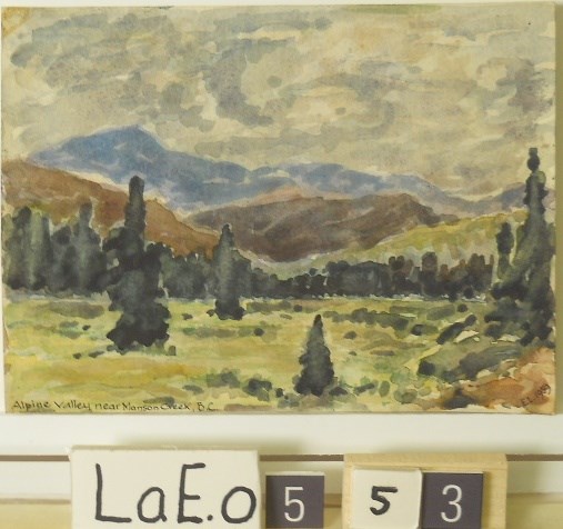
Alpine Valley near Manson Creek, B.C.
https://archives.whyte.org/en/permalink/artifactlae.05.53
- Date
- 1959
- Medium
- watercolour on paper
- Catalogue Number
- LaE.05.53
- Description
- see photobrhc E.L. 1959”
1 image
- Title
- Alpine Valley near Manson Creek, B.C.
- Date
- 1959
- Medium
- watercolour on paper
- Dimensions
- 13.9 x 18.0 cm
- Description
- see photobrhc E.L. 1959”
- Subject
- landscape
- mountains
- valley
- Ernest Lamarque
- Credit
- Gift of Ernest Lamarque (Estate), 1971
- Catalogue Number
- LaE.05.53
Images
This material is presented as originally created; it may contain outdated cultural descriptions and
potentially offensive content.
Read more.
An Outline Map of the Canadian Pacific Railway and Connecting Lines
https://archives.whyte.org/en/permalink/catalogue21429
- Medium
- Library - Maps and blueprints (unannotated; published)
- Map
- Published Date
- Checked to March 1925
- Call Number
- C11-3.2
- Published Date
- Checked to March 1925
- Subjects
- Canada
- Railway routes
- Notes
- World Cruises described on the reverse side of the map
- Accession Number
- 400
- Call Number
- C11-3.2
- Collection
- Archives Library
This material is presented as originally created; it may contain outdated cultural descriptions and
potentially offensive content.
Read more.
[Anahim Lake 93C, B.C.]
https://archives.whyte.org/en/permalink/catalogue24005
- Medium
- Library - Maps and blueprints (unannotated; published)
- Map
- Published Date
- 1955
- Publisher
- Dept. of Mines and Technical Surveys
- Call Number
- NTS
- 93C
- Publisher
- Dept. of Mines and Technical Surveys
- Published Date
- 1955
- Physical Description
- 1 map : col
- Scale
- Scale: 1:250,000
- Relief: Contour interval 500 ft.
- Subjects
- Anahim Lake
- British Columbia
- Accession Number
- 3000
- Call Number
- NTS
- 93C
- Collection
- Archives Library
This material is presented as originally created; it may contain outdated cultural descriptions and
potentially offensive content.
Read more.
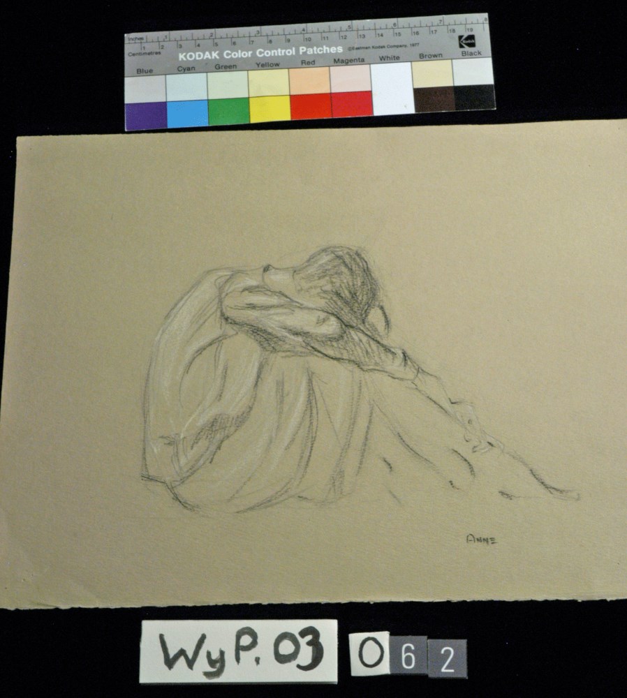
- Date
- 1916 – 1927
- Medium
- charcoal; pastel; on paper
- Catalogue Number
- WyP.03.062
- Description
- Person sitting with head bent over raised knees.
1 image
- Title
- Anne
- Date
- 1916 – 1927
- Medium
- charcoal; pastel; on paper
- Dimensions
- 26.4 x 33.3 cm
- Description
- Person sitting with head bent over raised knees.
- Credit
- Gift of Catharine Robb Whyte, O. C., Banff, 1975
- Catalogue Number
- WyP.03.062
Images
This material is presented as originally created; it may contain outdated cultural descriptions and
potentially offensive content.
Read more.
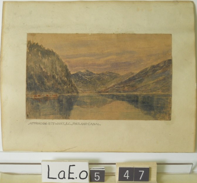
Approaching Stewart B.C., Portland Canal
https://archives.whyte.org/en/permalink/artifactlae.05.47
- Date
- 1921
- Medium
- watercolour on paper
- Catalogue Number
- LaE.05.47
- Description
- blhc to centre: EL.“APPROACHING STEWART, B.C., PORTLAND CANAL”
1 image
- Title
- Approaching Stewart B.C., Portland Canal
- Date
- 1921
- Medium
- watercolour on paper
- Dimensions
- 11.4 x 19.9 cm
- Description
- blhc to centre: EL.“APPROACHING STEWART, B.C., PORTLAND CANAL”
- Subject
- landscape
- mountains
- water
- Ernest Lamarque
- Credit
- Gift of Ernest Lamarque (Estate), 1971
- Catalogue Number
- LaE.05.47
Images
This material is presented as originally created; it may contain outdated cultural descriptions and
potentially offensive content.
Read more.
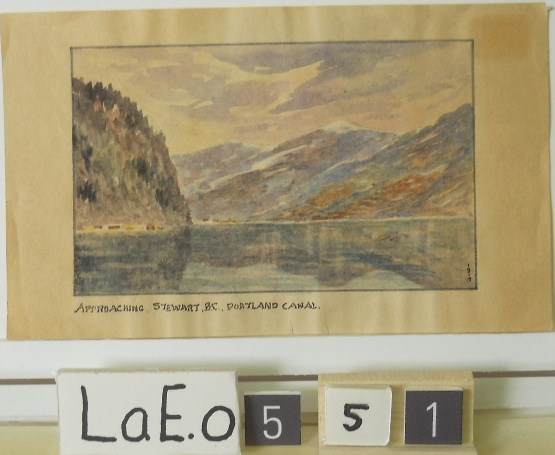
Approaching Stewart B.C. Portland Canal
https://archives.whyte.org/en/permalink/artifactlae.05.51
- Date
- 1919
- Medium
- watercolour on paper
- Catalogue Number
- LaE.05.51
1 image
- Title
- Approaching Stewart B.C. Portland Canal
- Date
- 1919
- Medium
- watercolour on paper
- Dimensions
- 8.7 x 14.1 cm
- Credit
- Gift of Ernest Lamarque (Estate), 1971
- Catalogue Number
- LaE.05.51
Images
This material is presented as originally created; it may contain outdated cultural descriptions and
potentially offensive content.
Read more.
[Arctic Regions] Map showing position of North Pole, Siberia, Greenland, Europe, North America etc. Ellesmere Island Region, Spitsbergen and Franz Josef Land
https://archives.whyte.org/en/permalink/catalogue24379
- Medium
- Library - Maps and blueprints (unannotated; published)
- Map
- Published Date
- 1925
- Publisher
- National Geographic Society
- Call Number
- C8-5.1
- Publisher
- National Geographic Society
- Published Date
- 1925
- Scale
- Scale: 231.6 miles to 1 inch
- Subjects
- Arctic Regions
- Accession Number
- 400
- Call Number
- C8-5.1
- Collection
- Archives Library
This material is presented as originally created; it may contain outdated cultural descriptions and
potentially offensive content.
Read more.
[Athabaska Falls 83C/12, Alberta]
https://archives.whyte.org/en/permalink/catalogue23455
- Medium
- Library - Maps and blueprints (unannotated; published)
- Map
- Published Date
- 1955
- Publisher
- Dept. of National Defence
- Call Number
- NTS
- 83C/12
- Publisher
- Dept. of National Defence
- Published Date
- 1955
- Physical Description
- 1 map : col
- Scale
- Scale: 1:50,000
- Relief: Contour interval 100'
- Subjects
- Athabaska Falls
- Alberta
- Notes
- National Topographic System
- Call Number
- NTS
- 83C/12
- Collection
- Archives Library
This material is presented as originally created; it may contain outdated cultural descriptions and
potentially offensive content.
Read more.
Athabaska Forest
https://archives.whyte.org/en/permalink/catalogue23248
- Medium
- Library - Maps and blueprints (unannotated; published)
- Map
- Published Date
- 1920 (signed Dec. 1919. Calgary/R.D.M)
- Publisher
- 1920 Forestry Branch
- Call Number
- C2-11.8
- Responsibility
- R.H. Campbell
- Publisher
- 1920 Forestry Branch
- Published Date
- 1920 (signed Dec. 1919. Calgary/R.D.M)
- Scale
- Scale: 3 miles to an inch
- Subjects
- Rocky Mountains Forest Reserve
- Notes
- Prepared under direction of R.H. Campbell Director of Forestry
- Call Number
- C2-11.8
- Collection
- Archives Library
This material is presented as originally created; it may contain outdated cultural descriptions and
potentially offensive content.
Read more.
(Athabaska River area) - junction with Snarling River
https://archives.whyte.org/en/permalink/catalogue24502
- Medium
- Library - Maps and blueprints (unannotated; published)
- Map
- Published Date
- February 24, 1911
- Publisher
- Department of the Interior
- Call Number
- C9-7.46
- Publisher
- Department of the Interior
- Published Date
- February 24, 1911
- Physical Description
- 1 map : black and white
- Scale
- 40 chains: 1 inch
- Accession Number
- SG7500
- Call Number
- C9-7.46
- Collection
- Archives Library
This material is presented as originally created; it may contain outdated cultural descriptions and
potentially offensive content.
Read more.
(Athabaska River-Talbot Lake area)
https://archives.whyte.org/en/permalink/catalogue24508
- Medium
- Library - Maps and blueprints (unannotated; published)
- Map
- Published Date
- October 19, 1911
- Publisher
- Department of the Interior
- Call Number
- C9-7.48
- Publisher
- Department of the Interior
- Published Date
- October 19, 1911
- Physical Description
- 1 map : black and white
- Scale
- 40 chains: 1 inch
- Accession Number
- SG7500
- Call Number
- C9-7.48
- Collection
- Archives Library
This material is presented as originally created; it may contain outdated cultural descriptions and
potentially offensive content.
Read more.
[Atlin 104N, B.C.]
https://archives.whyte.org/en/permalink/catalogue24007
- Medium
- Library - Maps and blueprints (unannotated; published)
- Map
- Published Date
- 1954
- Publisher
- Dept. of Mines and Technical Surveys
- Call Number
- NTS
- 104N
- Publisher
- Dept. of Mines and Technical Surveys
- Published Date
- 1954
- Physical Description
- 1 map : col
- Scale
- Scale: 1:250,000
- Relief: Contour interval 500 ft.
- Subjects
- Atlin
- British Columbia
- Notes
- National Topographic System
- Accession Number
- 3000
- Call Number
- NTS
- 104N
- Collection
- Archives Library
This material is presented as originally created; it may contain outdated cultural descriptions and
potentially offensive content.
Read more.
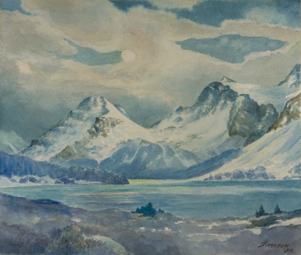
Autumn Evening, 1958
https://archives.whyte.org/en/permalink/artifactsij.05.60
- Date
- 1958
- Medium
- watercolour on paper
- Catalogue Number
- SiJ.05.60
- Description
- Cloudy, moonlit scene, mountains in background stretch across image, Bow Lake at the foot of the mountains in the foreground. In the immediate foreground at the bottom of the image is the shore of the lake, a few trees on it. At the centre left of the image, a line of trees on the bank extends i…
1 image
- Title
- Autumn Evening, 1958
- Date
- 1958
- Medium
- watercolour on paper
- Description
- Cloudy, moonlit scene, mountains in background stretch across image, Bow Lake at the foot of the mountains in the foreground. In the immediate foreground at the bottom of the image is the shore of the lake, a few trees on it. At the centre left of the image, a line of trees on the bank extends in towards the middle of the image.
- Subject
- landscape
- Canadian Rockies
- Bow Lake
- Credit
- Gift of James (Jr.) Simpson, Rocky Mountain House, 2000
- Catalogue Number
- SiJ.05.60
Images
This material is presented as originally created; it may contain outdated cultural descriptions and
potentially offensive content.
Read more.
- Medium
- Library - Maps and blueprints (unannotated; published)
- Map
- Published Date
- 1925
- Revision of map November, 1915
- Publisher
- Ottawa : Topographical Survey of Canada
- Call Number
- C3-1.2a
- Publisher
- Ottawa : Topographical Survey of Canada
- Published Date
- 1925
- Revision of map November, 1915
- Physical Description
- 1 map : col
- Scale
- 1:190,080
- Subjects
- Banff region
- Call Number
- C3-1.2a
- Collection
- Archives Library
This material is presented as originally created; it may contain outdated cultural descriptions and
potentially offensive content.
Read more.