Narrow Results By
William Royle fonds
https://archives.whyte.org/en/permalink/descriptions55701
- Part Of
- William Royle fonds
- Scope & Content
- Fonds consists of photographs, published booklets and film reels which belonged to William Royle. Content pertains to the Banff Boy Scouts: local events, including Banff Winter Carnival, Banff Indian Days and Banff's Centennial Parade in 1967; hiking, camping, skiing and other recreational activiti…
- Date Range
- [ca.1920-1930]
- 1959-1960
- [ca.1960-1970]
- 1978
- Reference Code
- M587 / V808
- Description Level
- 1 / Fonds
- GMD
- Photograph
- Transparency
- Textual record
- Published record
- Film
- Part Of
- William Royle fonds
- Description Level
- 1 / Fonds
- Fonds Number
- M587
- V808
- Sous-Fonds
- M587
- V808
- Accession Number
- 2021.29
- Reference Code
- M587 / V808
- Date Range
- [ca.1920-1930]
- 1959-1960
- [ca.1960-1970]
- 1978
- Physical Description
- ca.348 photographs (204 b&w and col. prints, 144 col. transparencies) -- 0.5 cm of textual records -- 7 film reels
- History / Biographical
- William "Bill" Royle (1905-1980) moved to Banff from Lethbridge in 1952 with his mother (Mary Elizabeth) and two young sons (Bernard and Walter), following the death of his wife. William started the business Banff Plumbing and Heating Ltd., which he operated until his death. William and his brother, John J. Royle, were also involved with a laundromat business in Banff. From its inception in 1953, William also worked as director and president of the Banff Park Savings and Credit Union (now Bow Valley Credit Union). In his spare time, William volunteered with the Banff Boy Scouts, as well as St. Mary's Church in Banff, the Seniors' Society and the Alberta Council of the Aging. William's son, Bernard, tragically passed away in a plane crash in 1969 while searching for new heliskiing routes in British Columbia with his friend, John Gow, who survived.
- Scope & Content
- Fonds consists of photographs, published booklets and film reels which belonged to William Royle. Content pertains to the Banff Boy Scouts: local events, including Banff Winter Carnival, Banff Indian Days and Banff's Centennial Parade in 1967; hiking, camping, skiing and other recreational activities; Bernard Royle and friends; the Banff High School curling team; natural views and wildlife in Alberta and British Columbia; and other related subjects. Includes three visual series: I - Prints ; II - Motion pictures ; III - Transparencies. Series I includes five sub-series: A - Boy Scouts [includes o.s. items] ; B - Banff Indian Days ; C - Banff Winter Carnival ; D - St. Mary's Baptist Church ; E - Misc.
- Name Access
- Royle, William
- Royle, Walter
- Royle, Bernard
- Subject Access
- Family and personal life
- Events
- Community events
- Sports
- Recreation
- Curling
- Banff Winter Carnival
- Banff Indian Days
- Cultural pluralism
- Scouting
- Boy Scouts of Canada
- Churches
- Religions
- Wildlife
- Geographic Access
- Canada
- Alberta
- Banff
- Banff National Park
- British Columbia
- Revelstoke
- Canmore
- Language
- English
- Biographical Source Notes
- https://time.com/5912476/heliski-survival-1969/
- Information provided by Walter Royle
- Title Source
- Title based on contents of fonds
- Processing Status
- Processed
This material is presented as originally created; it may contain outdated cultural descriptions and
potentially offensive content.
Read more.
British Columbia area
https://archives.whyte.org/en/permalink/descriptions56421
- Part Of
- Douglas Leighton fonds
- Scope & Content
- File consists of photographs of scenic views, tourism and people doing winter and summer activities in British Columbia.
- Date Range
- 1976
- 1979
- 1981
- 1983 - 1988
- 1990 - 1997
- 1999
- 2002
- Reference Code
- V222 / IV / B / 13 / NS - 1 to 136
- Description Level
- 5 / File
- GMD
- Photograph
- Transparency
- Part Of
- Douglas Leighton fonds
- Description Level
- 5 / File
- Fonds Number
- M133
- V222
- Series
- V222 / IV : Scenic Views
- Sous-Fonds
- V222
- Sub-Series
- V222 / IV / B: British Columbia
- Accession Number
- 2020.24
- Reference Code
- V222 / IV / B / 13 / NS - 1 to 136
- Date Range
- 1976
- 1979
- 1981
- 1983 - 1988
- 1990 - 1997
- 1999
- 2002
- Physical Description
- 136 photographs : col. slides ; 35 mm
- Scope & Content
- File consists of photographs of scenic views, tourism and people doing winter and summer activities in British Columbia.
- Name Access
- Leighton, Douglas
- Subject Access
- Activities
- Tourism
- scenic
- Geographic Access
- New Denver, BC
- Kaslo, BC
- Nelson, BC
- Kootenay National Park
- Radium, BC
- Vahalla Wilderness Park
- Edgewater, BC
- Glacier National Park
- Comox, BC
- Top of the World Provincial Park
- British Columbia
- Language
- English
- Creator
- Douglas Leighton
- Category
- Sports, recreation and leisure
- Tourism
- Title Source
- Title based on contents of file
- Processing Status
- Processed
This material is presented as originally created; it may contain outdated cultural descriptions and
potentially offensive content.
Read more.
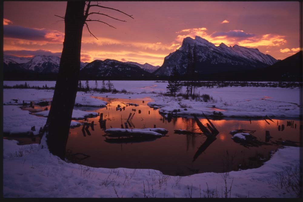
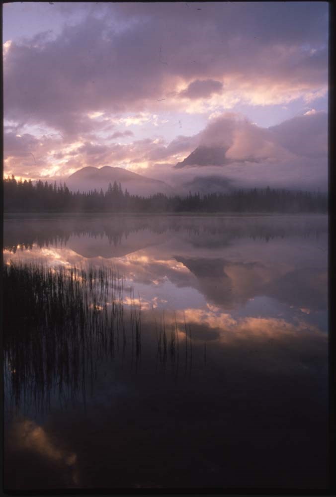
Canadian Rockies and other "active best"
https://archives.whyte.org/en/permalink/descriptions56446
- Part Of
- Douglas Leighton fonds
- Scope & Content
- File consists of photographs compiled by Douglas Leighton for publication. Includes photographs of landscapes, cityscapes, lakes, mountains, hotel, tourists, plants, waterfalls and glaciers.
- Date Range
- 1978
- 1981 - 1983
- 1987
- 1988
- 1990
- 1993 - 1995
- 1997
- 1998
- 2003
- 2006
- 2007
- Reference Code
- V222 / VI / C / 4 / NS - 1 to 119
- Description Level
- 5 / File
- GMD
- Photograph
- Transparency
4 images
- Part Of
- Douglas Leighton fonds
- Description Level
- 5 / File
- Fonds Number
- M133
- V222
- Series
- V222 / VI : Publication
- Sous-Fonds
- V222
- Sub-Series
- V222 / VI / C: Compiled for publication
- Accession Number
- 2020.24
- Reference Code
- V222 / VI / C / 4 / NS - 1 to 119
- Date Range
- 1978
- 1981 - 1983
- 1987
- 1988
- 1990
- 1993 - 1995
- 1997
- 1998
- 2003
- 2006
- 2007
- Physical Description
- 119 photographs : col. slides ; 35 mm
- Scope & Content
- File consists of photographs compiled by Douglas Leighton for publication. Includes photographs of landscapes, cityscapes, lakes, mountains, hotel, tourists, plants, waterfalls and glaciers.
- Name Access
- Leighton, Douglas
- Subject Access
- British Columbia
- Geographic Access
- Alberta
- British Columbia
- Banff National Park
- Banff
- Calgary, AB
- Edmonton, AB
- Kootenay, BC
- Yoho National Park
- Jasper National Park
- Cranbrook, BC
- Vancouver, BC
- Language
- English
- Creator
- Douglas Leighton
- Title Source
- Title based on contents of file
- Processing Status
- Processed
Images
This material is presented as originally created; it may contain outdated cultural descriptions and
potentially offensive content.
Read more.
- Part Of
- Ben Gadd fonds
- Scope & Content
- Sub-sub-series consists of ca.50 maps of various regions in Western Canada and Alaska which were collected by Ben Gadd. Maps are arranged according to associated highways which the mapped regions depict.
- Date Range
- [ca.1970-2005]
- Reference Code
- M590 / I / A / iv
- Description Level
- 4.1 / Sub-sub-series
- GMD
- Map
- Part Of
- Ben Gadd fonds
- Description Level
- 4.1 / Sub-sub-series
- Fonds Number
- M590
- V810
- S61
- Series
- M590 / I : Personal records
- Sous-Fonds
- M590
- Sub-Series
- M590 / I / A / iv : Travel guides and maps : Highway maps
- Accession Number
- 2021.20
- Reference Code
- M590 / I / A / iv
- GMD
- Map
- Date Range
- [ca.1970-2005]
- Physical Description
- ca.50 maps -- 4 paper scans of maps
- Scope & Content
- Sub-sub-series consists of ca.50 maps of various regions in Western Canada and Alaska which were collected by Ben Gadd. Maps are arranged according to associated highways which the mapped regions depict.
- Notes
- Regions included in file: Highway 3 Highway 6 Highway 11 Highway 16 Highway 22 & 40 Highway 93 [To Jasper] Highway 93 [To Radium] Highway 97 [Pine Pass] Highway 97 [Alaska Highway]
- Name Access
- Gadd, Ben
- Geographic Access
- Canada
- Alberta
- British Columbia
- Canadian Rocky Mountains
- Alaska
- Reproduction Restrictions
- Restrictions may apply
- Language
- English
- Title Source
- Title based on contents of file
- Processing Status
- Processed
This material is presented as originally created; it may contain outdated cultural descriptions and
potentially offensive content.
Read more.
Topographical maps
https://archives.whyte.org/en/permalink/descriptions56805
- Part Of
- Ben Gadd fonds
- Scope & Content
- Sub-sub series consists of topographical maps depicting various regions in Canada and the United States, which were collected by Ben Gadd. Includes ca.13 maps of regions in the United States (including Eagletail National Park in Arizona, Colorado Springs, and Montana); and ca.213 maps of regions in…
- Date Range
- [ca.1960-2005]
- Reference Code
- M590 / I / A / ii
- Description Level
- 4.1 / Sub-sub-series
- GMD
- Map
- Part Of
- Ben Gadd fonds
- Description Level
- 4.1 / Sub-sub-series
- Fonds Number
- M590
- V810
- S61
- Series
- M590 / I : Personal records
- Sous-Fonds
- M590
- Sub-Series
- M590 / I / A / ii : Travel guides and maps : Topographical maps
- Accession Number
- 2021.20
- Reference Code
- M590 / I / A / ii
- GMD
- Map
- Date Range
- [ca.1960-2005]
- Physical Description
- ca.226 topographical maps
- Scope & Content
- Sub-sub series consists of topographical maps depicting various regions in Canada and the United States, which were collected by Ben Gadd. Includes ca.13 maps of regions in the United States (including Eagletail National Park in Arizona, Colorado Springs, and Montana); and ca.213 maps of regions in Northern Canada, Western Canada and the Canadian Rockies (predominantly Alberta and British Columbia, as well as the Yukon).
- Notes
- Some maps include annotations by Ben Gadd
- Name Access
- Gadd, Ben
- Geographic Access
- Canada
- Alberta
- British Columbia
- Yukon
- Canadian Rocky Mountains
- Rocky Mountains
- Reproduction Restrictions
- Restrictions may apply
- Language
- English
- Category
- Exploration and travel
- Title Source
- Title based on contents of file
- Processing Status
- Processed
This material is presented as originally created; it may contain outdated cultural descriptions and
potentially offensive content.
Read more.
Travel guides - Alberta, British Columbia
https://archives.whyte.org/en/permalink/descriptions55920
- Part Of
- Ben Gadd fonds
- Scope & Content
- File consists of travel guides collected by Ben Gadd pertaining to various regions of Alberta and British Columbia.
- Date Range
- [ca.2000]
- 2008
- Reference Code
- M590 / I / A / i / 12
- Description Level
- 5 / File
- GMD
- Published record
- Textual record
- Map
- Part Of
- Ben Gadd fonds
- Description Level
- 5 / File
- Fonds Number
- M590
- V810
- S61
- Series
- M590 / I : Personal records
- Sous-Fonds
- M590
- Sub-Series
- M590 / I / A : Travel guides and maps
- Accession Number
- 2021.20
- Reference Code
- M590 / I / A / i / 12
- Date Range
- [ca.2000]
- 2008
- Physical Description
- 2 cm of textual records
- Scope & Content
- File consists of travel guides collected by Ben Gadd pertaining to various regions of Alberta and British Columbia.
- Notes
- Some items in file are annotated
- Subject Access
- Geography
- Travel
- Tourism
- Tourist information
- Geographic Access
- Canada
- Alberta
- British Columbia
- Reproduction Restrictions
- Copyright restrictions may apply
- Language
- English
- Category
- Exploration, discovery and travel
- Title Source
- Title based on contents of file
- Processing Status
- Processed
This material is presented as originally created; it may contain outdated cultural descriptions and
potentially offensive content.
Read more.
Travel guides - British Columbia
https://archives.whyte.org/en/permalink/descriptions55926
- Part Of
- Ben Gadd fonds
- Scope & Content
- File consists of travel guides collected by Ben Gadd pertaining to various locations in British Columbia, including Rogers Pass, Berg Lake Trail, Victoria and Vancouver.
- Date Range
- [ca.2000]
- 2003
- Reference Code
- M590 / I / A / i / 11
- Description Level
- 5 / File
- GMD
- Published record
- Textual record
- Map
- Part Of
- Ben Gadd fonds
- Description Level
- 5 / File
- Fonds Number
- M590
- V810
- S61
- Series
- M590 / I : Personal records
- Sous-Fonds
- M590
- Sub-Series
- M590 / I / A : Travel guides and maps
- Accession Number
- 2021.20
- Reference Code
- M590 / I / A / i / 11
- Date Range
- [ca.2000]
- 2003
- Physical Description
- 2 cm of textual records
- Scope & Content
- File consists of travel guides collected by Ben Gadd pertaining to various locations in British Columbia, including Rogers Pass, Berg Lake Trail, Victoria and Vancouver.
- Subject Access
- Geography
- Travel
- Tourism
- Tourist information
- Geographic Access
- Canada
- British Columbia
- Victoria
- Vancouver
- Rogers Pass
- Berg Lake
- Reproduction Restrictions
- Copyright restrictions may apply
- Language
- English
- Category
- Exploration, discovery and travel
- Title Source
- Title based on contents of file
- Processing Status
- Processed
This material is presented as originally created; it may contain outdated cultural descriptions and
potentially offensive content.
Read more.
Travel guides - Canadian Rockies, Montana
https://archives.whyte.org/en/permalink/descriptions55927
- Part Of
- Ben Gadd fonds
- Scope & Content
- File consists of travel guides collected by Ben Gadd pertaining to the Canadian Rockies, as well as regions in Montana.
- Date Range
- [ca.2000]
- 2009
- Reference Code
- M590 / I / A / i / 13
- Description Level
- 5 / File
- GMD
- Published record
- Textual record
- Map
- Part Of
- Ben Gadd fonds
- Description Level
- 5 / File
- Fonds Number
- M590
- V810
- S61
- Series
- M590 / I : Personal records
- Sous-Fonds
- M590
- Sub-Series
- M590 / I / A : Travel guides and maps
- Accession Number
- 2021.20
- Reference Code
- M590 / I / A / i / 13
- Date Range
- [ca.2000]
- 2009
- Physical Description
- 1 cm of textual records
- Scope & Content
- File consists of travel guides collected by Ben Gadd pertaining to the Canadian Rockies, as well as regions in Montana.
- Notes
- Some items in file are annotated
- Subject Access
- Geography
- Travel
- Tourism
- Tourist information
- Geographic Access
- Canada
- Alberta
- British Columbia
- Canadian Rocky Mountains
- United States of America
- Montana
- Reproduction Restrictions
- Copyright restrictions may apply
- Language
- English
- Category
- Exploration, discovery and travel
- Title Source
- Title based on contents of file
- Processing Status
- Processed
This material is presented as originally created; it may contain outdated cultural descriptions and
potentially offensive content.
Read more.
Travel guides - Icefields
https://archives.whyte.org/en/permalink/descriptions55917
- Part Of
- Ben Gadd fonds
- Scope & Content
- File consists of travel guides collected by Ben Gadd pertaining to Columbia Icefield, Icefields Parkway and the Wapta Icefields.
- Date Range
- 1994
- [ca.2000]
- Reference Code
- M590 / I / A / i / 7
- Description Level
- 5 / File
- GMD
- Published record
- Textual record
- Map
- Part Of
- Ben Gadd fonds
- Description Level
- 5 / File
- Fonds Number
- M590
- V810
- S61
- Series
- M590 / I : Personal records
- Sous-Fonds
- M590
- Sub-Series
- M590 / I / A : Travel guides and maps
- Accession Number
- 2021.20
- Reference Code
- M590 / I / A / i / 7
- Date Range
- 1994
- [ca.2000]
- Physical Description
- 1 cm of textual records
- Scope & Content
- File consists of travel guides collected by Ben Gadd pertaining to Columbia Icefield, Icefields Parkway and the Wapta Icefields.
- Notes
- Travel guide of Wapta Icefields includes annotations on cover by Ben Gadd.
- Subject Access
- Geography
- Travel
- Tourism
- Tourist information
- Geographic Access
- Canada
- Alberta
- Jasper National Park
- Columbia Icefield
- Icefields Parkway
- British Columbia
- Wapta Icefields
- Reproduction Restrictions
- Copyright restrictions may apply
- Language
- English
- Category
- Exploration, discovery and travel
- Title Source
- Title based on contents of file
- Processing Status
- Processed
This material is presented as originally created; it may contain outdated cultural descriptions and
potentially offensive content.
Read more.
Travel guides - Lake Louise, Yoho
https://archives.whyte.org/en/permalink/descriptions55913
- Part Of
- Ben Gadd fonds
- Scope & Content
- File consists of travel guides collected by Ben Gadd pertaining to areas near Lake Louise and Yoho National Park.
- Date Range
- 1998
- 2001
- Reference Code
- M590 / I / A / i / 3
- Description Level
- 5 / File
- GMD
- Published record
- Textual record
- Map
- Part Of
- Ben Gadd fonds
- Description Level
- 5 / File
- Fonds Number
- M590
- V810
- S61
- Series
- M590 / I : Personal records
- Sous-Fonds
- M590
- Sub-Series
- M590 / I / A : Travel guides and maps
- Accession Number
- 2021.20
- Reference Code
- M590 / I / A / i / 3
- Date Range
- 1998
- 2001
- Physical Description
- 2 cm of textual records
- Scope & Content
- File consists of travel guides collected by Ben Gadd pertaining to areas near Lake Louise and Yoho National Park.
- Subject Access
- Geography
- Travel
- Tourism
- Tourist information
- Geographic Access
- Canada
- Alberta
- British Columbia
- Lake Louise
- Yoho National Park
- Reproduction Restrictions
- Copyright restrictions may apply
- Language
- English
- Category
- Exploration, discovery and travel
- Title Source
- Title based on contents of file
- Processing Status
- Processed
This material is presented as originally created; it may contain outdated cultural descriptions and
potentially offensive content.
Read more.
Travel guides and maps
https://archives.whyte.org/en/permalink/descriptions56361
- Part Of
- Ben Gadd fonds
- Scope & Content
- Sub-series consists of travel brochures and maps which were collected and used by Ben Gadd. Sub-series contains five sub-sub series: M590 / I / A / i : Travel guides and pocket maps M590 / I / A / ii : Topographical maps M590 / I / A / iii : Geological maps M590 / I / A / iv : Highway maps M590 / …
- Date Range
- [ca.1920-2010]
- Reference Code
- M590 / I / A
- Description Level
- 4 / Sub-series
- GMD
- Map
- Textual record
- Part Of
- Ben Gadd fonds
- Description Level
- 4 / Sub-series
- Fonds Number
- M590
- V810
- S61
- Series
- M590 / I : Personal records
- Sous-Fonds
- M590
- Sub-Series
- M590 / I / A : Travel guides and maps
- Accession Number
- 2021.20
- Reference Code
- M590 / I / A
- GMD
- Map
- Textual record
- Date Range
- [ca.1920-2010]
- Physical Description
- ca. 274 maps -- ca. 61 travel guides, brochures
- Scope & Content
- Sub-series consists of travel brochures and maps which were collected and used by Ben Gadd. Sub-series contains five sub-sub series: M590 / I / A / i : Travel guides and pocket maps M590 / I / A / ii : Topographical maps M590 / I / A / iii : Geological maps M590 / I / A / iv : Highway maps M590 / I / A / v : Index maps, other
- Notes
- Some materials in sub-series are annotated with notes by Ben Gadd
- Name Access
- Gadd, Ben
- Subject Access
- Geography
- Geology
- Environment
- Map
- Tourism
- Tourist information
- Travel
- Trails
- Roads
- Transportation
- Natural history
- National parks and reserves
- Provincial parks and reserves
- Government
- Sports
- Recreation
- Hiking
- Geographic Access
- Canada
- Alberta
- British Columbia
- Banff National Park
- Jasper National Park
- Kootenay National Park
- Yoho National Park
- Waterton Lakes National Park
- Columbia Icefields
- United States of America
- Colorado
- Montana
- Yellowstone National Park
- Access Restrictions
- Restrictions may apply - some materials are fragile
- Reproduction Restrictions
- Restrictions may apply
- Language
- English
- Conservation
- Some fragile/torn materials stored in mylar
- Category
- Environment
- Exploration, discovery and travel
- Government
- Sports, recreation and leisure
- Transportation
- Tourism
- Title Source
- Title based on contents of sub-series
- Processing Status
- Processed
This material is presented as originally created; it may contain outdated cultural descriptions and
potentially offensive content.
Read more.
Travel guides and pocket maps
https://archives.whyte.org/en/permalink/descriptions56806
- Part Of
- Ben Gadd fonds
- Scope & Content
- Sub-sub-series consists of ca.30 travel maps and guides collected by Ben Gadd, primarily pertaining to regions in the United States. Includes regions in Colorado, Arizona, British Columbia, Alberta and Saskatchewan.
- Date Range
- [ca.1970-2005]
- Reference Code
- M590 / I / A / i
- Description Level
- 4.1 / Sub-sub-series
- GMD
- Map
- Part Of
- Ben Gadd fonds
- Description Level
- 4.1 / Sub-sub-series
- Fonds Number
- M590
- V810
- S61
- Series
- M590 / I : Personal records
- Sous-Fonds
- M590
- Sub-Series
- M590 / I / A / i : Travel guides and pocket maps
- Accession Number
- 2021.20
- Reference Code
- M590 / I / A / i
- GMD
- Map
- Date Range
- [ca.1970-2005]
- Physical Description
- ca.30 travel guides and maps
- Scope & Content
- Sub-sub-series consists of ca.30 travel maps and guides collected by Ben Gadd, primarily pertaining to regions in the United States. Includes regions in Colorado, Arizona, British Columbia, Alberta and Saskatchewan.
- Name Access
- Gadd, Ben
- Geographic Access
- Canada
- Alberta
- British Columbia
- Saskatchewan
- Canadian Rocky Mountains
- United States of America
- Colorado
- Arizona
- Reproduction Restrictions
- Restrictions may apply
- Language
- English
- Title Source
- Title based on contents of file
- Processing Status
- Processed
This material is presented as originally created; it may contain outdated cultural descriptions and
potentially offensive content.
Read more.