Narrow Results By
[British Columbia Forestry] Map showing forest stand types
https://archives.whyte.org/en/permalink/catalogue24537
- Medium
- Library - Maps and blueprints (unannotated; published)
- Map
- Published Date
- 1917
- Publisher
- Commission of Conservation Can.
- Call Number
- C10-9.1
- Publisher
- Commission of Conservation Can.
- Published Date
- 1917
- Scale
- Scale: 25 miles to the inch
- Subjects
- British Columbia
- Forestry
- Notes
- Accompanies "Forests of British Columbia" by H.N. Whitford 04.1/Wh
- 1 duplicate
- Accession Number
- 400
- Call Number
- C10-9.1
- Collection
- Archives Library
This material is presented as originally created; it may contain outdated cultural descriptions and
potentially offensive content.
Read more.
[British Columbia Game map] Sketch map showing game districts and regulations
https://archives.whyte.org/en/permalink/catalogue24541
- Medium
- Library - Maps and blueprints (unannotated; published)
- Map
- Published Date
- 1926
- Publisher
- Charles F. Banfield, Victoria
- Call Number
- C10-11.1
- Publisher
- Charles F. Banfield, Victoria
- Published Date
- 1926
- Scale
- Scale: 1 inch - 64 miles
- Subjects
- British Columbia
- Game map
- Notes
- Game regulations on reverse side of map
- Accession Number
- 400
- Call Number
- C10-11.1
- Collection
- Archives Library
This material is presented as originally created; it may contain outdated cultural descriptions and
potentially offensive content.
Read more.
Kootenay district, B.C.
https://archives.whyte.org/en/permalink/catalogue24519
- Medium
- Library - Maps and blueprints (unannotated; published)
- Map
- Published Date
- 1915
- Publisher
- Department of Lands, B.C.
- Call Number
- C10-2.3
- Publisher
- Department of Lands, B.C.
- Published Date
- 1915
- Scale
- Scale: 1:500,000
- Accession Number
- 400
- Call Number
- C10-2.3
- Collection
- Archives Library
This material is presented as originally created; it may contain outdated cultural descriptions and
potentially offensive content.
Read more.
Map showing the northern paortion of Vancouver Island
https://archives.whyte.org/en/permalink/catalogue24531
- Medium
- Library - Maps and blueprints (unannotated; published)
- Map
- Published Date
- 1919
- Publisher
- Dept. of Lands/Honourable T.D. Pattullo. J.E. Umbach Surveyor General
- Call Number
- C10-5.1
- Publisher
- Dept. of Lands/Honourable T.D. Pattullo. J.E. Umbach Surveyor General
- Published Date
- 1919
- Scale
- Scale: 4 miles - 1 inch
- Subjects
- British Columbia
- Vancouver Island
- Accession Number
- 400
- Call Number
- C10-5.1
- Collection
- Archives Library
This material is presented as originally created; it may contain outdated cultural descriptions and
potentially offensive content.
Read more.
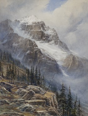
Mt. Stephan, B.C.
https://archives.whyte.org/en/permalink/artifactfrt.05.01
- Date
- 1925
- Medium
- watercolour on paper
- Catalogue Number
- FrT.05.01
- Description
- Mountain scene with rocky cliff interspersed with stands of conifers at left foreground. Large mountain [Mt. Stephen] with snow filled central gully and snow-capped peak in background. Signed “Thos W. Fripp 1925” at bottom left.
1 image
- Title
- Mt. Stephan, B.C.
- Date
- 1925
- Medium
- watercolour on paper
- Dimensions
- 51.0 x 38.0 cm
- Description
- Mountain scene with rocky cliff interspersed with stands of conifers at left foreground. Large mountain [Mt. Stephen] with snow filled central gully and snow-capped peak in background. Signed “Thos W. Fripp 1925” at bottom left.
- Subject
- mountains
- Mt. Stephen
- British Columbia
- Credit
- Gift of Rod Green, Calgary, 2021
- Catalogue Number
- FrT.05.01
Images
This material is presented as originally created; it may contain outdated cultural descriptions and
potentially offensive content.
Read more.
[Northern Peace River Sheet] Pre-emptor's map
https://archives.whyte.org/en/permalink/catalogue24525
- Medium
- Library - Maps and blueprints (unannotated; published)
- Map
- Published Date
- 1928
- Publisher
- Department of Lands, B.C.
- Call Number
- C10-3.3
- Publisher
- Department of Lands, B.C.
- Published Date
- 1928
- Scale
- Scale: 4 miles: 1 inch
- Subjects
- British Columbia
- Northern Peace River
- Accession Number
- 495
- Call Number
- C10-3.3
- Collection
- Archives Library
This material is presented as originally created; it may contain outdated cultural descriptions and
potentially offensive content.
Read more.
[Province of British Columbia]
https://archives.whyte.org/en/permalink/catalogue21419
- Medium
- Library - Maps and blueprints (unannotated; published)
- Map
- Published Date
- 1912
- Publisher
- Dept. of Lands, Victoria
- Call Number
- C10-10.2
- Publisher
- Dept. of Lands, Victoria
- Published Date
- 1912
- Subjects
- British Columbia
- Accession Number
- 400
- Call Number
- C10-10.2
- Collection
- Archives Library
This material is presented as originally created; it may contain outdated cultural descriptions and
potentially offensive content.
Read more.
[Province of British Columbia]
https://archives.whyte.org/en/permalink/catalogue24539
- Medium
- Library - Maps and blueprints (unannotated; published)
- Map
- Published Date
- 1912
- Publisher
- Dept. of Lands, Victoria
- Call Number
- C10-10.2
- Publisher
- Dept. of Lands, Victoria
- Published Date
- 1912
- Scale
- Scale: 35 miles - 1 inch
- Subjects
- British Columbia
- Accession Number
- 400
- Call Number
- C10-10.2
- Collection
- Archives Library
This material is presented as originally created; it may contain outdated cultural descriptions and
potentially offensive content.
Read more.
[Wildermere, Southern B.C.]
https://archives.whyte.org/en/permalink/catalogue24517
- Medium
- Library - Maps and blueprints (unannotated; published)
- Map
- Published Date
- 1918
- Publisher
- Department of Mines
- Call Number
- C10-2.1
- Publisher
- Department of Mines
- Published Date
- 1918
- Physical Description
- 1 map : col
- Scale
- Scale: 1:125,000
- Relief: Contour interval 200 ft.
- Subjects
- British Columbia
- Windermere
- Notes
- Duplicate = C3-4.1
- Accession Number
- 400
- Call Number
- C10-2.1
- Collection
- Archives Library
This material is presented as originally created; it may contain outdated cultural descriptions and
potentially offensive content.
Read more.
[Yale District, Southern B.C.] British Columbia
https://archives.whyte.org/en/permalink/catalogue24518
- Medium
- Library - Maps and blueprints (unannotated; published)
- Map
- Published Date
- 1912
- Publisher
- Dept. of Lands & Works, B.C.
- Call Number
- C10-2.2
- Publisher
- Dept. of Lands & Works, B.C.
- Published Date
- 1912
- Scale
- Scale: 1 inch - 8 miles
- Accession Number
- 400
- Call Number
- C10-2.2
- Collection
- Archives Library
This material is presented as originally created; it may contain outdated cultural descriptions and
potentially offensive content.
Read more.


