Narrow Results By
Canadian Rockies : they abound in wild animals, glaciers, and luxurious hotels
https://archives.whyte.org/en/permalink/catalogue24918
- Medium
- Library - Book (including soft-cover and pamphlets)
- Published Date
- 1947
- Publisher
- Life
- Call Number
- 02.6 L11c PAM OS
1 website
- Publisher
- Life
- Published Date
- 1947
- Subjects
- Banff National Park
- Travel
- Tourism
- Banff Springs Hotel
- Rundle Mount
- Athabaska River
- Brazeau
- Maligne Lake
- Bow River
- Canadian National Railway
- Canadian Pacific Railway
- Chateau Lake Louise
- Trails
- Mountaineering
- Columbia Icefield
- Abstract
- Pertains to the Canadian Rocky Mountains as a tourist destination in 1947 and features main geographical attractions such as the Mount Rundle, Athabaska River, Maligne Lake, Bow River in addition to the Banff Springs Hotel with map of Banff National Park and Jasper National Park.
- Notes
- In Life, June 9, 1947, pp. 68 - 76
- Accession Number
- 7889
- Call Number
- 02.6 L11c PAM OS
- Collection
- Archives Library
- URL Notes
- Specific volume with article can be viewed online via Google Books
Websites
This material is presented as originally created; it may contain outdated cultural descriptions and
potentially offensive content.
Read more.
New rivers of the north : the yarn of two amateur explorers
https://archives.whyte.org/en/permalink/catalogue3777
- Medium
- Library - Book (including soft-cover and pamphlets)
- Published Date
- 1913
- Author
- Footner, William Hulbert
- Publisher
- London : T. Fisher Unwin
- Call Number
- 02.5 F73
- Author
- Footner, William Hulbert
- Publisher
- London : T. Fisher Unwin
- Published Date
- 1913
- Physical Description
- 281p. : ill., ports., map
- Subjects
- Boating
- Fraser River
- Peace River
- Selwyn, Mount
- Accession Number
- 400
- Call Number
- 02.5 F73
- Collection
- Archives Library
This material is presented as originally created; it may contain outdated cultural descriptions and
potentially offensive content.
Read more.
Preliminary map : Bighorn River, Alberta
https://archives.whyte.org/en/permalink/catalogue24728
- Medium
- Library - Book (including soft-cover and pamphlets)
- Map
- Published Date
- 1941
- Author
- MacKay, B.R.
- Publisher
- Ottawa: Geological Survey of Canada
- Call Number
- C7-2.12, C7-2.12a
- Author
- MacKay, B.R.
- Publisher
- Ottawa: Geological Survey of Canada
- Published Date
- 1941
- Physical Description
- 2 maps
- Scale
- Sccale: 2 inches = 1 mile
- Notes
- Map 41-9
- Accession Number
- 5000
- Call Number
- C7-2.12, C7-2.12a
- Collection
- Archives Library
This material is presented as originally created; it may contain outdated cultural descriptions and
potentially offensive content.
Read more.
AAF aeronautical chart : North Saskatchewan River / compiled for the U.S. Army Air Forces by the U.S. Coast and Geodetic Survey
https://archives.whyte.org/en/permalink/catalogue24364
- Medium
- Library - Maps and blueprints (unannotated; published)
- Map
- Published Date
- 1943
- Publisher
- Washington, D.C.
- Call Number
- C6-12.1
- Publisher
- Washington, D.C.
- Published Date
- 1943
- Physical Description
- 1 map : col
- Scale
- 1 : 1,000,000
- Subjects
- Saskatchewan River, North
- Aviation
- Accession Number
- 4008
- Call Number
- C6-12.1
- Collection
- Archives Library
This material is presented as originally created; it may contain outdated cultural descriptions and
potentially offensive content.
Read more.
Alberta : Athabaska sheet
https://archives.whyte.org/en/permalink/catalogue24415
- Medium
- Library - Maps and blueprints (unannotated; published)
- Map
- Published Date
- 1914
- Publisher
- Ottawa: Office of the Surveyor General
- Edition
- 2d ed.
- Call Number
- C9-2.4
- Edition
- 2d ed.
- Publisher
- Ottawa: Office of the Surveyor General
- Published Date
- 1914
- Physical Description
- 1 map
- Scale
- Scale: 1:190,080
- Subjects
- Athabaska River
- Notes
- Sectional map
- Accession Number
- 5576
- 4008
- Call Number
- C9-2.4
- Collection
- Archives Library
This material is presented as originally created; it may contain outdated cultural descriptions and
potentially offensive content.
Read more.
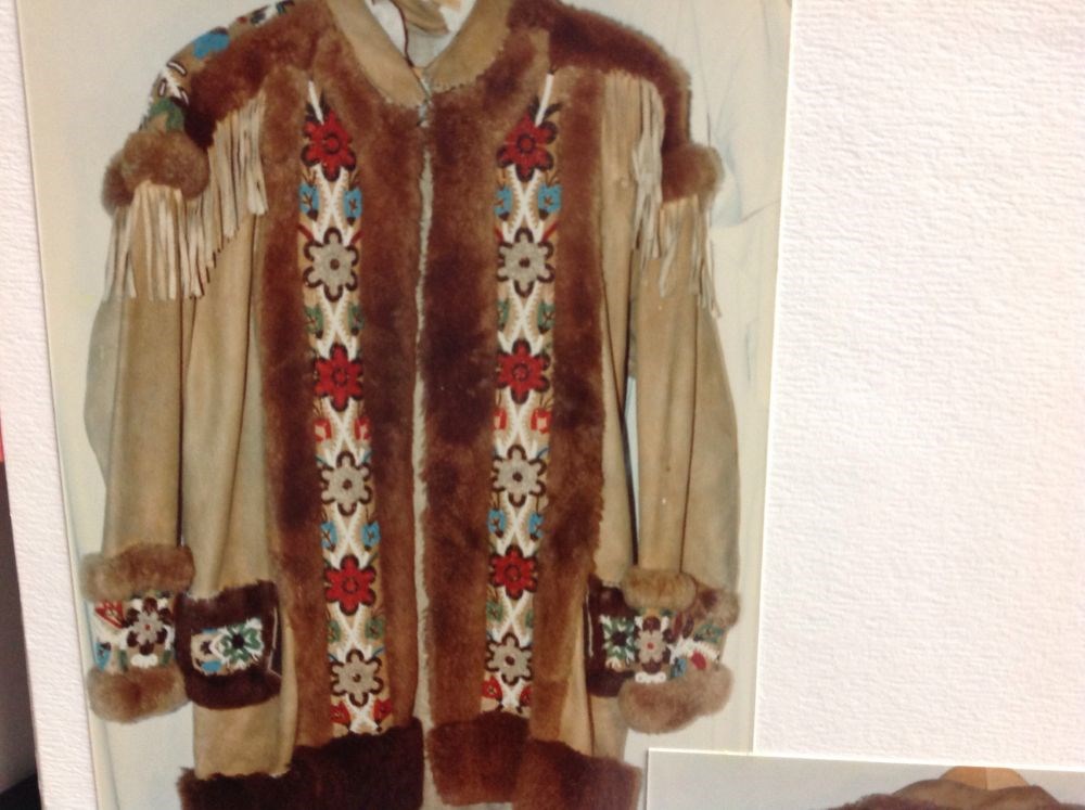
- Date
- 1945 – 1950
- Material
- skin, moose; hair, beaver; glass
- Catalogue Number
- 103.05.1019
- Description
- Fur trimmed, straight-cut, beaded jacket with beaded cuffs, woodland floral designs in brown/white/blue/green, beaded yoke, front panels and pocket flaps, buckskin fringe at shoulders and back, beaver fur outlines all beaded areas and bottom edge.
1 image
- Title
- Beaded Jacket
- Date
- 1945 – 1950
- Material
- skin, moose; hair, beaver; glass
- Dimensions
- 54.0 x 88.0 cm
- Description
- Fur trimmed, straight-cut, beaded jacket with beaded cuffs, woodland floral designs in brown/white/blue/green, beaded yoke, front panels and pocket flaps, buckskin fringe at shoulders and back, beaver fur outlines all beaded areas and bottom edge.
- Credit
- Gift of Mary Wrig Burles, 1969
- Catalogue Number
- 103.05.1019
Images
This material is presented as originally created; it may contain outdated cultural descriptions and
potentially offensive content.
Read more.
Bow Fort Site
https://archives.whyte.org/en/permalink/catalogue23331
- Medium
- Library - Maps and blueprints (unannotated; published)
- Map
- Published Date
- Jan., 1913
- Publisher
- Water Power Branch
- Call Number
- C5-6.4
- Publisher
- Water Power Branch
- Published Date
- Jan., 1913
- Scale
- 400 feet to the inch
- Notes
- (accompanies Bow River Power and Storage Investigations by M.C. Hendry 03.6)
- Accession Number
- 576
- Call Number
- C5-6.4
- Collection
- Archives Library
This material is presented as originally created; it may contain outdated cultural descriptions and
potentially offensive content.
Read more.
Bow Lake Storage Basin, Topographic Sheet No. 16
https://archives.whyte.org/en/permalink/catalogue23347
- Medium
- Library - Maps and blueprints (unannotated; published)
- Map
- Published Date
- Jan., 1913
- Publisher
- Water Power Branch
- Call Number
- C5-6.16
- Publisher
- Water Power Branch
- Published Date
- Jan., 1913
- Scale
- 400 feet to the inch
- Notes
- (accompanies Bow River Power and Storage Investigations by M.C. Hendry 03.6)
- Accession Number
- 576
- Call Number
- C5-6.16
- Collection
- Archives Library
This material is presented as originally created; it may contain outdated cultural descriptions and
potentially offensive content.
Read more.
[Bow River Basin above Calgary]
https://archives.whyte.org/en/permalink/catalogue24417
- Medium
- Library - Maps and blueprints (unannotated; published)
- Map
- Published Date
- 1912
- Publisher
- Dept. of the Interior Water Power Branch
- Call Number
- C9-3.2
- Publisher
- Dept. of the Interior Water Power Branch
- Published Date
- 1912
- Scale
- Scale: 4 miles: 1 inch
- Relief: Contour interval 500 ft.
- Subjects
- Bow River Basin
- Notes
- 2 duplicates in map room - Accn. 400
- Accession Number
- 400
- Call Number
- C9-3.2
- Collection
- Archives Library
This material is presented as originally created; it may contain outdated cultural descriptions and
potentially offensive content.
Read more.
Cascade River Power Site, Topographic Sheet 8
https://archives.whyte.org/en/permalink/catalogue23349
- Medium
- Library - Maps and blueprints (unannotated; published)
- Map
- Published Date
- Jan., 1913
- Publisher
- Water Power Branch
- Call Number
- C5-6.18
- Publisher
- Water Power Branch
- Published Date
- Jan., 1913
- Scale
- 50 feet to the inch
- Notes
- (accompanies Bow River Power and Storage Investigations by M.C. Hendry 03.6)
- Accession Number
- 576
- Call Number
- C5-6.18
- Collection
- Archives Library
This material is presented as originally created; it may contain outdated cultural descriptions and
potentially offensive content.
Read more.