Narrow Results By
Report of the Commission Appointed to Delimit the Boundary between the Provinces of Alberta and British Columbia - Part II - from 1917 to 1921
https://archives.whyte.org/en/permalink/catalogue24922
- Medium
- Library - Book (including soft-cover and pamphlets)
- Published Date
- 1923
- Author
- Alberta and British Columbia Boundary Commission
- Publisher
- Ottawa : Kings Printer
- Call Number
- 03.2 Al1ab A Atlas oversize copy 2 Part II 1917-1921
- 03.2 Al1ab A Atlas oversize and report copy 3 Part II 1917-1921
- Responsibility
- R.W. Cautley
- J.N Wallace
- A.O. Wheeler
- Publisher
- Ottawa : Kings Printer
- Published Date
- 1923
- Physical Description
- 1 atlas : illustrations ; 1 report
- Subjects
- Monuments and historic markers
- Surveys
- Boundaries
- Alberta
- British Columbia
- British Columbia - Boundaries
- British Columbia - Surveys and Mapping
- Alberta - B.C. Boundary
- Alberta - Boundaries
- Alberta British Columbia Boundary Commission
- Wheeler, Arthur Oliver
- Cautley, Richard William
- Wallace, James Nevin
- Atlases
- Maps
- Notes
- Atlas and report
- Accession Number
- 7202
- 8114
- Call Number
- 03.2 Al1ab A Atlas oversize copy 2 Part II 1917-1921
- 03.2 Al1ab A Atlas oversize and report copy 3 Part II 1917-1921
- Collection
- Archives Library
This material is presented as originally created; it may contain outdated cultural descriptions and
potentially offensive content.
Read more.
Report of the Commission Appointed to Delimit the Boundary between the Provinces of Alberta and British Columbia - Part III - from 1918 to 1924
https://archives.whyte.org/en/permalink/catalogue24923
- Medium
- Library - Book (including soft-cover and pamphlets)
- Published Date
- 1925
- Author
- Alberta and British Columbia Boundary Commission
- Publisher
- Ottawa : Kings Printer
- Call Number
- 03.2 Al1ab A Atlas oversize copy 2 Part III 1918-1924
- 03.2 Al1ab A Atlas oversize and report copy 3 Part III 1918-1924
- Responsibility
- R.W. Cautley
- A.O. Wheeler
- Publisher
- Ottawa : Kings Printer
- Published Date
- 1925
- Physical Description
- 1 atlas : illustrations ; 1 report
- Subjects
- Monuments and historic markers
- Surveys
- Boundaries
- Alberta
- British Columbia
- British Columbia - Boundaries
- British Columbia - Surveys and Mapping
- Alberta - B.C. Boundary
- Alberta - Boundaries
- Alberta British Columbia Boundary Commission
- Wheeler, Arthur Oliver
- Cautley, Richard William
- Wallace, James Nevin
- Atlases
- Maps
- Notes
- Atlas and report
- Accession Number
- 7202
- 8114
- Call Number
- 03.2 Al1ab A Atlas oversize copy 2 Part III 1918-1924
- 03.2 Al1ab A Atlas oversize and report copy 3 Part III 1918-1924
- Collection
- Archives Library
This material is presented as originally created; it may contain outdated cultural descriptions and
potentially offensive content.
Read more.
Eagle Valley - our legacy
https://archives.whyte.org/en/permalink/catalogue25283
- Medium
- Library - Book (including soft-cover and pamphlets)
- Published Date
- May 2018
- Author
- Macklin, Anne
- McCullough, Douglas
- Henry, Lynne
- Souster, Bill
- Greif, Frank
- Publisher
- Cochrane, AB : Satellite Printing Ltd.
- Call Number
- 08.2 E1e
1 website
- Responsibility
- The Eagle Valley Working Group
- Anne Macklin
- Douglas McCullough
- Lynne Henry
- Bill Souster
- Frank Greif
- Publisher
- Cochrane, AB : Satellite Printing Ltd.
- Published Date
- May 2018
- Physical Description
- 7 sections ; illustrations (some colour), colour maps
- Abstract
- In August 2016, a group of about 40 residents as well as a couple of county councillors met at the Eagle Valley Community Hall to discuss the process of creating a new area structure plan under the oversight of a steering committee. The result of that meeting was a consensus to create a working group to provide the county with input as well as to help officials “understand who we are as a community, the commitment that we have to the land we live on, and our heritage, cultural and social resources that are in the community,”.Five volunteers — Anne Macklin, Lynne Henry, Douglas McCullough, Bill Souster and Greif — formed the Eagle Valley Working Group, which is not affiliated with any recognized societies already in the region. Over the following six months, a questionnaire was formulated to glean information from the community’s residents. A summary of the survey’s results was then discussed during a meeting held at the Sundre Petroleum Operators Group’s office this past January. When the process started, a number of important stakeholders in terms of working relationships were identified, such as the oil and gas industry, social services including Greenwood Neighbourhood Place as well as the Town of Sundre. So following January’s meeting, the working group was tasked with preparing the legacy document. Included within its pages is information about Eagle Valley’s climate, oil and gas sector, geology, as well as infrastructure issues such as roads, wastewater, water, parks and recreation. A copy of the book, is available for sale at the Sundre Municipal Library. (Summarized from Mountainview Today article - website)
- Contents
- Reader's guide
- Introduction and background
- Pride of ownership
- Sense of values
- Environmental harmony
- Stewardship of resources
- Property protection and personal security
- Legislative and management framework
- Appendices
- Accession Number
- P2020.07
- Call Number
- 08.2 E1e
- Collection
- Archives Library
- URL Notes
- Article with further information
Websites
This material is presented as originally created; it may contain outdated cultural descriptions and
potentially offensive content.
Read more.
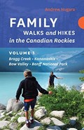
Family walks and hikes in the Canadian Rockies. Volume 1 : Bragg Creek - Kananaskis - Bow Valley - Banff National Park
https://archives.whyte.org/en/permalink/catalogue25204
- Medium
- Library - Book (including soft-cover and pamphlets)
- Published Date
- 2019
- Author
- Nugara, Andrew
- Publisher
- [Victoria, BC] : Rocky Mountain Books Ltd.
- Call Number
- 02.6 N89f Vol. 1
1 website
- Author
- Nugara, Andrew
- Responsibility
- Andrew Nugara
- Publisher
- [Victoria, BC] : Rocky Mountain Books Ltd.
- Published Date
- 2019
- Physical Description
- xx, 156 pages) : color illustrations, color maps
- Subjects
- Hiking
- Travel
- Banff National Park
- Kootenay National Park
- Highways
- Highways - Alberta
- Kananaskis Country
- Maps
- Lake Louise
- Lake Louise - Roads & Trails
- Abstract
- Family Walks and Hikes is an exciting new series of books written specifically for outdoor enthusiasts of all ages and abilities. These accurate, attractive guides feature expertly curated routes, informative maps, and colour photographs. The first book for the Canadian Rockies in the series brings together an inspiring collection of comfortable walks and spectacular hikes for visitors and locals looking for unique, guided wanderings in a number of diverse locations in the Rockies, including: Elbow Falls Powderface Ridge Troll Falls Elbow Lake Grotto Canyon Grassi Lakes Tunnel Mountain Johnston Canyon Stanley Glacier Plain Of Six Glaciers Bow Summit Ranging from charmingly easy to moderately challenging, these hikes are all accessible from reliable roads and popular staging areas. In addition, each hike is accompanied by a clear, colourful map, step by step directions, and full-colour photographs. Each route includes: detailed directions to trailheads colour maps and photographs seasonal information round-trip distances trail commentary difficulty ratings (from Rocky Mountain Books website)
- Contents
- Introduction
- Area Maps
- Highway 66, The Elbow
- Highway 40 South, Kananaskis Trail
- Highway 1, Bow Valley, Canmore, Highway 742 South
- Banff
- Kootenay National Park
- Lake Louise
- Icefield Parkway (Highway 93 North(
- Important Contacts
- Acknowledgements
- ISBN
- 9781771602242
- Accession Number
- P2020.07
- Call Number
- 02.6 N89f Vol. 1
- Collection
- Archives Library
- URL Notes
- Publishers website
Websites
This material is presented as originally created; it may contain outdated cultural descriptions and
potentially offensive content.
Read more.
Family walks and hikes in the Canadian Rockies. Volume 2 : Bragg Creek , Kananaskis , Moraine Lake , Yoho , Icefields Parkway , Jasper
https://archives.whyte.org/en/permalink/catalogue25205
- Medium
- Library - Book (including soft-cover and pamphlets)
- Published Date
- 2019
- Author
- Nugara, Andrew
- Publisher
- [Victoria, BC] : Rocky Mountain Books Ltd.
- Edition
- First
- Call Number
- 02.6 N89f Vol. 2
1 website
- Author
- Nugara, Andrew
- Responsibility
- Andrew Nugara
- Edition
- First
- Publisher
- [Victoria, BC] : Rocky Mountain Books Ltd.
- Published Date
- 2019
- Physical Description
- volumes : colour illustrations, colour maps ; 22 cm
- Subjects
- Hiking
- Travel
- Kananaskis Country
- Maps
- Highways
- Highways - Alberta
- Banff
- Moraine Lake
- Yoho National Park
- Jasper
- Abstract
- amily Walks and Hikes is an exciting series of books written specifically for outdoor enthusiasts of all ages and abilities. These accurate, attractive guides feature expertly curated routes, informative maps, and colour photographs. Andrew Nugara’s second book for families looking to experience the splendour of the Canadian Rockies describes additional trips in Bragg Creek, Banff, and Kananaskis that were not included in Volume 1 due to redevelopment of these hiking hotspots since the dramatic Alberta floods of 2013. As well, Volume 2 includes several new areas for family exploration, including Moraine Lake, Yoho, the north section of Highway 93 North, and Jasper. Some of the comfortable walks and spectacular hikes in this new volume are: Forgetmenot Ponds Nihahi Ridge King Creek Canyon Canadian Everest Trail Picklejar Lakes Yamnuska Ha Ling Peak Sunshine Meadows Paget Peak Lookout Takakkaw Falls Parker Ridge Athabasca Glacier Sunwapta Falls Maligne Canyon Ranging from charmingly easy to moderately challenging, all of these hikes are accessible from reliable roads and popular staging areas. In addition, each hike is accompanied by a clear, colourful map, step by step directions, and full-colour photographs. Each route includes: detailed directions to trailheads colour maps and photographs seasonal information round-trip distances trail commentary difficulty ratings (from Rocky Mountain Books website)
- Contents
- Introduction
- Area Maps
- Highway 66, the Elbow
- Highway 40 South, Kananaskis Trail
- Highway 1, Bow Valley, Canmore, Highway 742 South
- Banff Area
- Moraine Lake
- Yoho National Park
- Icefields Parkway (Highway 93 North)
- Jasper
- Important Contacts
- Acknowledgements
- Disclaimer
- ISBN
- 9781771603058
- Accession Number
- P2020.07
- Call Number
- 02.6 N89f Vol. 2
- Collection
- Archives Library
- URL Notes
- Publishers website
Websites
This material is presented as originally created; it may contain outdated cultural descriptions and
potentially offensive content.
Read more.

Where rivers meet : photographs and stories from the Bow Valley and the Kananaskis
https://archives.whyte.org/en/permalink/catalogue25282
- Medium
- Library - Book (including soft-cover and pamphlets)
- Published Date
- 2018
- Author
- Legault, Stephen
- Publisher
- [Victoria, British Columbia] : RMB
- Call Number
- 03.5 L46w
1 website
- Author
- Legault, Stephen
- Responsibility
- Stephen Legault
- Publisher
- [Victoria, British Columbia] : RMB
- Published Date
- 2018
- Physical Description
- 208 pages : illustrations (some colour), colour maps
- Subjects
- Hydrology
- Hydrology - Alberta
- Rivers
- Water
- Watersheds
- Bow River Basin
- Spray River
- Highwood Pass
- Maps
- Photography
- Abstract
- Until the 1980s, Kananaskis Country, the Bow Valley and Canmore were places most people drove past on their way to Ban National Park, Lake Louise, Jasper and points beyond. Today, Kananaskis Country gets more than three million visitors a year, and Canmore is a town twice the size of Banff. Encompassing a dizzying array of natural environments, from grasslands and foothills to deep mountain valleys and sweeping alpine vistas, Kananaskis Country and the Bow Valley attract visitors from around the world each year to this mountain paradise. Calgarians consider this landscape to be their backyard and they turn to it for recreation, solace and wilderness adventure. Where Rivers Meet will bring the beauty and wonder of this profound landscape and its wild creatures to visitors from around the world and local residents alike. This artistically designed coffee table book features over 200 black and white and colour images together with short essays and personal reflections on natural history, geology, the cultural background and the region’s communities, as well as the threats and solutions to development and social challenges found throughout Kananaskis Country and the Bow Valley. (From publisher's website)
- Contents
- Introduction
- The Bow Valley
- The Spray Valley
- The Kananaskis Valley
- The Highwood/Cataract
- The Elbow and Sheep Rivers
- Oz-ada Imne
- Epilogue: A love song
- Gratitude
- About the author
- Maps
- ISBN
- 9781771602396
- Accession Number
- P2020.07
- Call Number
- 03.5 L46w
- Location
- Reading Room
- Collection
- Archives Library
- URL Notes
- Publisher's website
Websites
This material is presented as originally created; it may contain outdated cultural descriptions and
potentially offensive content.
Read more.