Narrow Results By
3.Jasper National Park [b.Columbia Icefield area]. -- [ca.1930-ca.1970]
https://archives.whyte.org/en/permalink/descriptions3584
- Part Of
- Lawrence Grassi fonds
- Scope & Content
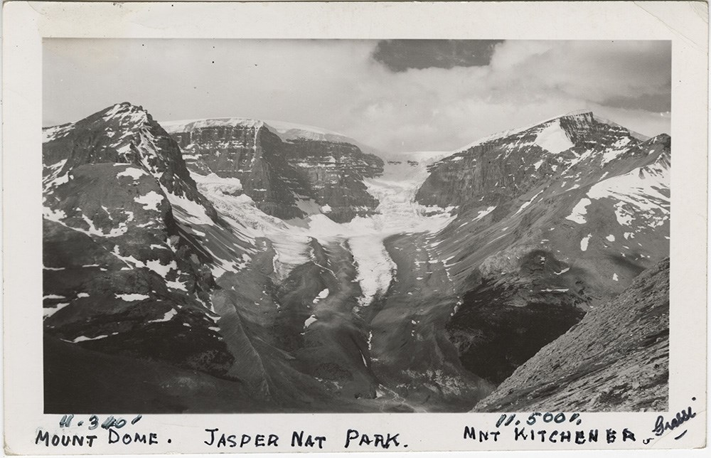
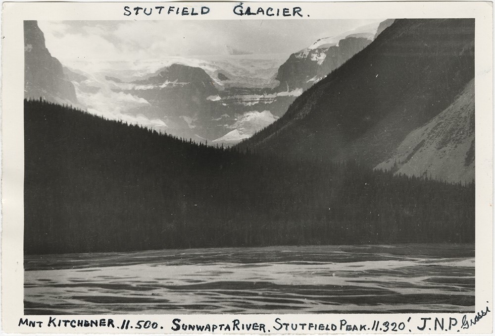
- Pertains to Mount Athabasca, Athabasca Glacier, Snow Dome and Stutfield Glacier.
- Date Range
- 1930-1970
- Reference Code
- V240 / 385 - 407
- Description Level
- 5 / File
- GMD
- Photograph, print
2 images
- Part Of
- Lawrence Grassi fonds
- Description Level
- 5 / File
- Fonds Number
- V227
- Series
- II.A. Landscape photographs
- Sous-Fonds
- V227
- Reference Code
- V240 / 385 - 407
- Date Range
- 1930-1970
- Physical Description
- 34 photographs : prints, negatives
- Scope & Content
- Pertains to Mount Athabasca, Athabasca Glacier, Snow Dome and Stutfield Glacier.
- Access Restrictions
- Access to negatives is by appointment only
- Processing Status
- Processed
Images
This material is presented as originally created; it may contain outdated cultural descriptions and
potentially offensive content.
Read more.
[Antarctic Regions]
https://archives.whyte.org/en/permalink/catalogue24849
- Medium
- Library - Maps and blueprints (unannotated; published)
- Map
- Published Date
- 1932
- Publisher
- National Geographic Society
- Call Number
- C13-10.1
- Publisher
- National Geographic Society
- Published Date
- 1932
- Scale
- 252.2 miles to 1 inch
- Subjects
- Antarctic Regions
- Accession Number
- 400
- Call Number
- C13-10.1
- Collection
- Archives Library
This material is presented as originally created; it may contain outdated cultural descriptions and
potentially offensive content.
Read more.
- Medium
- Library - Maps and blueprints (unannotated; published)
- Map
- Published Date
- 1933
- Publisher
- National Geographic Society
- Call Number
- C13-8.1
- Publisher
- National Geographic Society
- Published Date
- 1933
- Scale
- 237 miles to 1 inch
- Subjects
- Asia
- Accession Number
- 400
- Call Number
- C13-8.1
- Collection
- Archives Library
This material is presented as originally created; it may contain outdated cultural descriptions and
potentially offensive content.
Read more.
[Atlantic Ocean]
https://archives.whyte.org/en/permalink/catalogue24848
- Medium
- Library - Maps and blueprints (unannotated; published)
- Map
- Published Date
- 1939
- Publisher
- National Geographic Society
- Call Number
- C13-9.1
- Publisher
- National Geographic Society
- Published Date
- 1939
- Scale
- 316 miles to 1 inch
- Subjects
- Atlantic Ocean
- Accession Number
- 400
- Call Number
- C13-9.1
- Collection
- Archives Library
This material is presented as originally created; it may contain outdated cultural descriptions and
potentially offensive content.
Read more.
Automobile Road Map of Alberta
https://archives.whyte.org/en/permalink/catalogue24397
- Medium
- Library - Maps and blueprints (unannotated; published)
- Map
- Published Date
- 1939
- Publisher
- Alberta Motor Association
- Call Number
- C9-1.8
- Publisher
- Alberta Motor Association
- Published Date
- 1939
- Scale
- Scale: 17 1/2 miles to the inch
- Subjects
- Alberta-Highways
- Accession Number
- 2511
- 2933
- Call Number
- C9-1.8
- Collection
- Archives Library
This material is presented as originally created; it may contain outdated cultural descriptions and
potentially offensive content.
Read more.
Automobile Road Map of Alberta
https://archives.whyte.org/en/permalink/catalogue24398
- Medium
- Library - Maps and blueprints (unannotated; published)
- Map
- Published Date
- 1939
- Publisher
- Alberta Motor Association
- Call Number
- C9-1.8
- Publisher
- Alberta Motor Association
- Published Date
- 1939
- Scale
- Scale: 17 1/2 miles to the inch
- Subjects
- Alberta-Highways
- Accession Number
- 2511
- 2933
- Call Number
- C9-1.8
- Collection
- Archives Library
This material is presented as originally created; it may contain outdated cultural descriptions and
potentially offensive content.
Read more.
Banff National Park, Yoho Park and Kootenay Park
https://archives.whyte.org/en/permalink/catalogue21448
- Medium
- Library - Maps and blueprints (unannotated; published)
- Map
- Published Date
- 1930
- Publisher
- C.P.R.
- Call Number
- C3-6.3(b)
- Publisher
- C.P.R.
- Published Date
- 1930
- Physical Description
- Colour
- Subjects
- Canadian Rockies
- Notes
- Panoramic map showing main and branch lines of C.P.R. Railway
- Accession Number
- 1230
- Call Number
- C3-6.3(b)
- Collection
- Archives Library
This material is presented as originally created; it may contain outdated cultural descriptions and
potentially offensive content.
Read more.
- Medium
- Library - Maps and blueprints (unannotated; published)
- Map
- Published Date
- 1932
- Publisher
- Department of the Interior
- Call Number
- C2-1.1
- Publisher
- Department of the Interior
- Published Date
- 1932
- Physical Description
- 1 map : col
- Scale
- Scale: 3 miles : 1 inch
- Relief: Contour interval 250'
- Subjects
- Banff National Park
- Accession Number
- 400 (4 maps)
- 1003
- 2684
- Call Number
- C2-1.1
- Collection
- Archives Library
This material is presented as originally created; it may contain outdated cultural descriptions and
potentially offensive content.
Read more.
[Banff Townsite]
https://archives.whyte.org/en/permalink/catalogue23270
- Medium
- Library - Maps and blueprints (unannotated; published)
- Map
- Published Date
- June, 1930
- Publisher
- Winnipeg: Western Canada Insurance Underwriters Ass'n
- Call Number
- C4-1.14, 1930
- Publisher
- Winnipeg: Western Canada Insurance Underwriters Ass'n
- Published Date
- June, 1930
- Scale
- Scale: 1"-400'
- Subjects
- Banff townsite
- Notes
- 10 sheets of maps showing Business Lots, Recreation Areas, Population, Schools of Banff townsite in 1930
- See also: C4-1.14(a)
- Fire insurance map
- Accession Number
- 400
- Call Number
- C4-1.14, 1930
- Collection
- Archives Library
This material is presented as originally created; it may contain outdated cultural descriptions and
potentially offensive content.
Read more.
[Bearberry 820/15 West, Alberta]
https://archives.whyte.org/en/permalink/catalogue23487
- Medium
- Library - Maps and blueprints (unannotated; published)
- Map
- Published Date
- 1937
- Publisher
- Dept. of Mines and Technical Surveys
- Call Number
- NTS
- 820/15W
- Publisher
- Dept. of Mines and Technical Surveys
- Published Date
- 1937
- Physical Description
- 1 map : black and white
- Scale
- Scale: 1:50,000
- Relief: Contour interval 100'
- Notes
- National Topographic System
- Call Number
- NTS
- 820/15W
- Collection
- Archives Library
This material is presented as originally created; it may contain outdated cultural descriptions and
potentially offensive content.
Read more.