Narrow Results By
Mather family fonds
https://archives.whyte.org/en/permalink/descriptions269
- Part Of
- Mather family fonds
- Scope & Content
- Fonds consists of three series: I. Mather family; II. Bow River Boat House Ltd.; III. Other material. I. Mather family, 1895-1945, 2.5 cm of textual records, ca.900 photographs (negatives, prints), 3 photograph albums (486 prints), 4 cartographic records. Textual records consist of marriage and b…
- Date Range
- 1895-1953
- Reference Code
- M87 / V397
- Description Level
- 1 / Fonds
- GMD
- Photograph
- Album
- Negative
- Photograph print
- Textual record
- Corporate record
- Map
- Private record
- Published record
- Part Of
- Mather family fonds
- Description Level
- 1 / Fonds
- Fonds Number
- M 87
- V 397
- Sous-Fonds
- M 87
- V 397
- Accession Number
- 309, 594, 1788, 2153, 2788, 3121, 3264
- Reference Code
- M87 / V397
- GMD
- Photograph
- Album
- Negative
- Photograph print
- Textual record
- Corporate record
- Map
- Private record
- Published record
- Date Range
- 1895-1953
- Physical Description
- 13 cm of textual records. -- ca.900 photographs : negatives, prints. -- 3 photograph albums (486 prints)
- History / Biographical
- The Mather family were boat house operators at Banff, Alberta, Canada. William Mather, 1868-1927, emigrated to Ontario from Scotland in 1880 and came west ca.1888 to work for the Eau Claire Lumber Company on the Spray River near Banff. He worked for Raymond M. Rooper's boat house business on the Bow River and, in 1899, purchased the business. The Mather business included steamer tours in the summer and also involved winter sports on the Bow River. William Mather and Margaret McRavey Mather had four children, Jennie, Leslie, Allan and Hazel. With William Mather's death in 1927, the family incorporated its interests as the Bow River Boat House Limited, with Allan Mather as manager. The operation expanded to Lake Minnewanka in 1939. After Allan Mather's death in 1951, the business was sold to Ed Mader
- Scope & Content
- Fonds consists of three series: I. Mather family; II. Bow River Boat House Ltd.; III. Other material.
- I. Mather family, 1895-1945, 2.5 cm of textual records, ca.900 photographs (negatives, prints), 3 photograph albums (486 prints), 4 cartographic records. Textual records consist of marriage and birth certificates, 1896-1900; boathouse and property records, 1895-1917; estate papers, 1928-1943; agreements, 1929, 1931; and, stock certificates, 1929-1945. Photographs consist of: Mather family negatives, [before ca.1945?]; Jennie Mather photographs, [ca.1910-ca.1930]; Leslie Mather photographs, ca.1910-ca.1940; Other photographs, ca.1910-ca.1930. Photographs pertain to Mather family, activities, friends; Mather home and properties; boats and boating on Lake Minnewanka and the Bow River; winter sports, including skating, hockey and skiing; hiking, floods, Banff area mountain views and Rocky Mountain scenic views
- II. Bow River Boat House Ltd., 1929-1951, 7.5 cm of textual records. Series consists of agreements and certificates, 1938-1950; correspondence re Minnewanka bungalow camp, 1941-1942; financial statements, 1937-1951. Maps show locations of Mather and Bow River Boat House Ltd. leaseholds.
- III. Other material, [192-]-1953, 3 cm of textual records.
- Name Access
- Mather, Allan
- Mather, Jennie
- Mather, Leslie
- Mather, William
- Subject Access
- Bow River Boat House
- Family and personal life
- Minnewanka, Lake
- Sports, recreation and leisure
- Access Restrictions
- No restrictions on access
- Photographs are in the public domain (other restrictions may apply)
- Copyright, privacy, commercial use and other restrictions may apply
- Language
- Language is English
- Finding Aid
- Finding aids and reference tools: arrangement outline
- series and file description
- electronic finding aid
- Creator
- Mather, William
- Mather, Allan
- Title Source
- Title based on contents of fonds
- Processing Status
- Processed
This material is presented as originally created; it may contain outdated cultural descriptions and
potentially offensive content.
Read more.
Hiking trails in the Lake Louise, Paradise Valley, Moraine Lake and Lake O'Hara areas
https://archives.whyte.org/en/permalink/catalogue24326
- Medium
- Library - Maps and blueprints (unannotated; published)
- Map
- Published Date
- 1959?
- Publisher
- Ottawa: Canadian Government Travel Bureau
- Call Number
- C6-4.3pb
- Publisher
- Ottawa: Canadian Government Travel Bureau
- Published Date
- 1959?
- Physical Description
- 1 map : col
- Scale
- 3/4 inch = 1 mile
- Subjects
- Lake Louise region
- Lake O'Hara region
- Notes
- Textual information on reverse. Compiled in cooperation with The National Parks of Canada.
- Info file transfer
- Call Number
- C6-4.3pb
- Collection
- Archives Library
This material is presented as originally created; it may contain outdated cultural descriptions and
potentially offensive content.
Read more.
Hiking trails in the Lake Louise, Paradise Valley, Moraine Lake and Lake O'Hara areas
https://archives.whyte.org/en/permalink/catalogue23393
- Medium
- Library - Maps and blueprints (unannotated; published)
- Map
- Published Date
- 1959?
- Publisher
- Ottawa: Canadian Government Travel Bureau
- Call Number
- C6-4.3pb
- Publisher
- Ottawa: Canadian Government Travel Bureau
- Published Date
- 1959?
- Physical Description
- 1 map : col
- Scale
- 3/4 inch = 1 mile
- Subjects
- Lake Louise region
- Lake O'Hara region
- Notes
- Textual information on reverse. Compiled in cooperation with The National Parks of Canada.
- Info file transfer
- Call Number
- C6-4.3pb
- Collection
- Archives Library
This material is presented as originally created; it may contain outdated cultural descriptions and
potentially offensive content.
Read more.
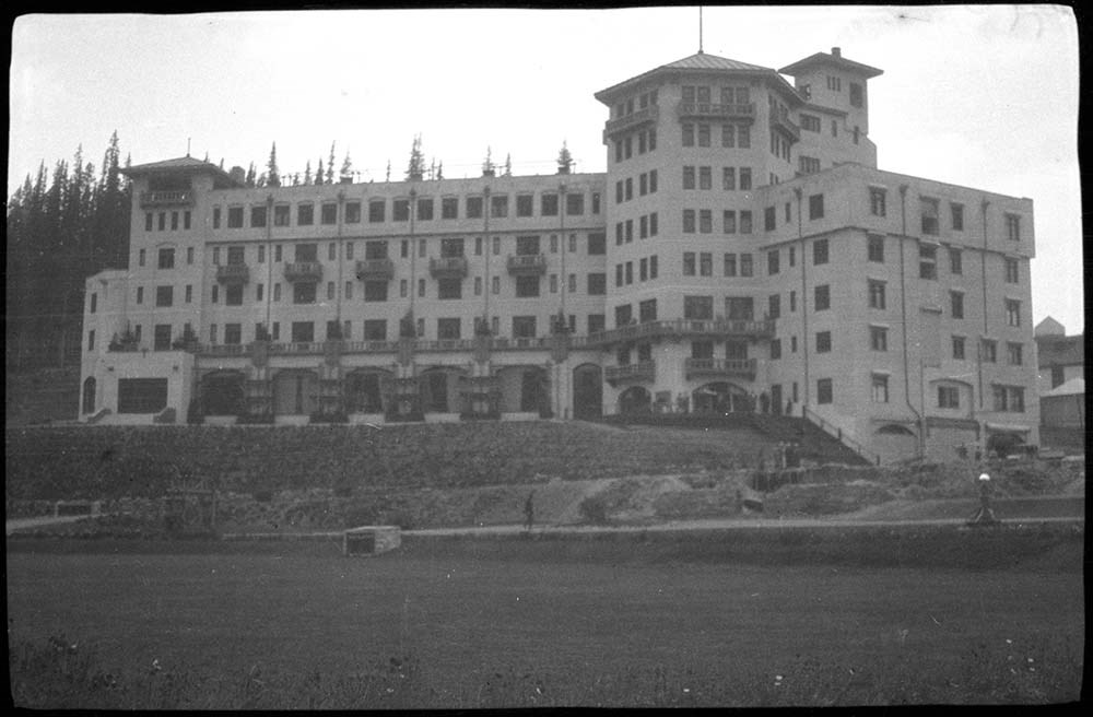
[Personal photographs]
https://archives.whyte.org/en/permalink/descriptions23836
- Part Of
- Luxton family fonds
- Scope & Content
- File consists of negatives depicting big horn sheep, canyons, Chateau Lake Louise, the Luxton House and garden.
- Date Range
- [1940-1960]
- Reference Code
- LUX / I / E4 / NA - 49 to NA - 53
- Description Level
- 5 / File
- GMD
- Photograph
- Negative
5 images
- Part Of
- Luxton family fonds
- Description Level
- 5 / File
- Fonds Number
- LUX
- Series
- LUX / I / E : Collected Material
- Sous-Fonds
- LUX / I : Norman Luxton sous-fonds
- Sub-Series
- LUX / I / E / 4 : Photographs
- Reference Code
- LUX / I / E4 / NA - 49 to NA - 53
- GMD
- Photograph
- Negative
- Date Range
- [1940-1960]
- Physical Description
- 5 photographs: b&w negatives ; 7.5 x 4.5 cm
- Scope & Content
- File consists of negatives depicting big horn sheep, canyons, Chateau Lake Louise, the Luxton House and garden.
- Subject Access
- Chateau Lake Louise
- Lake Louise
- Big Horn
- Big Horn Sheep
- Geographic Access
- Banff
- Banff National Park
- Lake Louise
- Processing Status
- Processed
Images


This material is presented as originally created; it may contain outdated cultural descriptions and
potentially offensive content.
Read more.
[Anahim Lake 93C, B.C.]
https://archives.whyte.org/en/permalink/catalogue24005
- Medium
- Library - Maps and blueprints (unannotated; published)
- Map
- Published Date
- 1955
- Publisher
- Dept. of Mines and Technical Surveys
- Call Number
- NTS
- 93C
- Publisher
- Dept. of Mines and Technical Surveys
- Published Date
- 1955
- Physical Description
- 1 map : col
- Scale
- Scale: 1:250,000
- Relief: Contour interval 500 ft.
- Subjects
- Anahim Lake
- British Columbia
- Accession Number
- 3000
- Call Number
- NTS
- 93C
- Collection
- Archives Library
This material is presented as originally created; it may contain outdated cultural descriptions and
potentially offensive content.
Read more.
Banff National Park and Lake Louise maps
https://archives.whyte.org/en/permalink/descriptions54945
- Scope & Content
- File consists of two folded maps and a small clipping [possibly top or bottom portion from a different map or one of maps in file]. One map is of Banff National Park and one is of Lake Louise [1959]. Banff National Park map has black pencil tracings over trail section near the bottom of the map and…
- Date Range
- 1959
- [1960-1970]
- Reference Code
- M545 / V / 53
- Description Level
- 5 / File
- GMD
- Textual record
- Published record
- Map
- Description Level
- 5 / File
- Fonds Number
- M545 / V635
- Series
- M545 / V : Administrative records
- Sous-Fonds
- M545
- Accession Number
- 8235
- Reference Code
- M545 / V / 53
- Date Range
- 1959
- [1960-1970]
- Physical Description
- 0.5 cm of textual records (2 maps ; 60.5 x 57.5 and 60 x 56.5 cm)
- Scope & Content
- File consists of two folded maps and a small clipping [possibly top or bottom portion from a different map or one of maps in file]. One map is of Banff National Park and one is of Lake Louise [1959]. Banff National Park map has black pencil tracings over trail section near the bottom of the map and annotation in bottom right corner which reads "Natural Bridge". Lake Louise map produced by the Government of Canada.
- Subject Access
- Banff National Park
- Environment
- Geography
- Map
- Lake Louise
- Travel
- Government
- National parks and reserves
- Trails
- Geographic Access
- Canada
- Alberta
- Banff National Park
- Lake Louise
- Language
- English
- Conservation
- Clipping stored in mylar due to significant staining and residue from tape
- Items kept folded [not placed in mylar] due to mass production of content and minimal/no annotations
- Title Source
- Title based on contents of file
- Processing Status
- Processed
This material is presented as originally created; it may contain outdated cultural descriptions and
potentially offensive content.
Read more.
[Bowser Lake 104A, B.C.]
https://archives.whyte.org/en/permalink/catalogue24011
- Medium
- Library - Maps and blueprints (unannotated; published)
- Map
- Published Date
- 1954
- Publisher
- Dept. of Mines and Technical Surveys
- Call Number
- NTS
- 104A
- Publisher
- Dept. of Mines and Technical Surveys
- Published Date
- 1954
- Physical Description
- 1 map : co
- Scale
- Scale: 1:250,000
- Relief: Contour interval 500 ft.
- Subjects
- Bowser Lake
- British Columbia
- Notes
- National Topographic System
- Accession Number
- 3000
- Call Number
- NTS
- 104A
- Collection
- Archives Library
This material is presented as originally created; it may contain outdated cultural descriptions and
potentially offensive content.
Read more.
B.S. Hotel "Oldies", B.S. Hotel Golf, Balfour Glacier, Timberline Hotel, Lake Louise "Oldies"
https://archives.whyte.org/en/permalink/descriptions54298
- Part Of
- Nicholas Morant fonds
- Scope & Content
- File consists of 23 negative photographs (colour and b&w), 30 colour transparencies and 1 colour print. Content pertains to Banff National Park AB views. Includes Balfour Glacier, Hector Lake, Bow Lake, Banff Springs Hotel, Banff Springs Hotel golf course, views from Chateau Lake Louise (1960s), Ti…
- Date Range
- [ca. 1960 - ca. 1970] [ca. 1965]
- Reference Code
- V500 / I / A7 / 30
- Description Level
- 4.2 / Sub-sub-sub series
- GMD
- Photograph
- Negative
- Transparency
- Part Of
- Nicholas Morant fonds
- Description Level
- 4.2 / Sub-sub-sub series
- Fonds Number
- M300 / S20 / V500
- Sous-Fonds
- V500
- Sub-Series
- V500 / I / A : Negatives and Transparencies
- Accession Number
- 7438
- Reference Code
- V500 / I / A7 / 30
- Responsibility
- Nicholas Morant
- Date Range
- [ca. 1960 - ca. 1970] [ca. 1965]
- Physical Description
- 54 Photographs: negatives, transparencies, print; b&w and colour
- Scope & Content
- File consists of 23 negative photographs (colour and b&w), 30 colour transparencies and 1 colour print. Content pertains to Banff National Park AB views. Includes Balfour Glacier, Hector Lake, Bow Lake, Banff Springs Hotel, Banff Springs Hotel golf course, views from Chateau Lake Louise (1960s), Timberline Hotel, Banff. Print photograph depicts bagpipe player near Banff Springs Hotel.
- Notes
- Contains duplicates. Negatives, transparencies and print stored in separate file boxes.
- Subject Access
- Banff National Park
- Banff Springs Hotel
- Chateau Lake Louise
- Hotel
- tourism
- Geographic Access
- Canada
- Alberta
- Banff
- Reproduction Restrictions
- Reference use only; no reproduction
- Language
- English
- Creator
- Nicholas Morant
- Title Source
- Title based on contents of file
- Processing Status
- Processed
This material is presented as originally created; it may contain outdated cultural descriptions and
potentially offensive content.
Read more.
Chateau Lake Louise and District
https://archives.whyte.org/en/permalink/descriptions54287
- Part Of
- Nicholas Morant fonds
- Scope & Content
- File consists of 10 negative photographs (b&w and colour) and 4 colour transparencies. Content pertains to Chateau Lake Louise, Canadian Pacific Railway hotel, Banff National Park, AB. Includes exterior views, swimming pool, activities; also region, including Mirror Lake and lower village area. One…
- Date Range
- [ca. 1950 - ca. 1960]
- ca. 1955
- Reference Code
- V500 / I / A7 / 22
- Description Level
- 4.2 / Sub-sub-sub series
- GMD
- Photograph
- Negative
- Transparency
- Part Of
- Nicholas Morant fonds
- Description Level
- 4.2 / Sub-sub-sub series
- Fonds Number
- M300 / S20 / V500
- Sous-Fonds
- V500
- Sub-Series
- V500 / I / A : Photography : Negatives and Transparencies
- Accession Number
- 7438
- Reference Code
- V500 / I / A7 / 22
- Responsibility
- Produced by Nicholas Morant
- Date Range
- [ca. 1950 - ca. 1960]
- ca. 1955
- Physical Description
- 14 Photographs: negatives and transparencies, b&w and colour
- Scope & Content
- File consists of 10 negative photographs (b&w and colour) and 4 colour transparencies. Content pertains to Chateau Lake Louise, Canadian Pacific Railway hotel, Banff National Park, AB. Includes exterior views, swimming pool, activities; also region, including Mirror Lake and lower village area. One image dated "ca. 1955".
- Notes
- Negatives and transparencies have been stored in separate file boxes. Contains duplicates of some images.
- Subject Access
- Chateau Lake Louise
- Hotel
- Canadian Pacific
- Swimming
- Geographic Access
- Canada
- Alberta
- Banff
- Access Restrictions
- Items in this file are not to be accessed or distributed without the explicit permission of their identified copyright owners.
- Reproduction Restrictions
- Reference use only; no reproduction
- Language
- English
- Creator
- Nicholas Morant
- Title Source
- Title based on contents of file
- Processing Status
- Processed
This material is presented as originally created; it may contain outdated cultural descriptions and
potentially offensive content.
Read more.
[Cry Lake 104 I B.C.]
https://archives.whyte.org/en/permalink/catalogue24032
- Medium
- Library - Maps and blueprints (unannotated; published)
- Map
- Published Date
- 1952
- Publisher
- Dept. of Mines and Technical Surveys
- Call Number
- NTS
- 104I
- Publisher
- Dept. of Mines and Technical Surveys
- Published Date
- 1952
- Physical Description
- Colour
- Scale
- Scale: 1:250,000
- Relief: Contour interval 500 ft.
- Subjects
- Cry Lake 104 I B.C.
- Notes
- National Topographic System
- Accession Number
- 3000
- Call Number
- NTS
- 104I
- Collection
- Archives Library
This material is presented as originally created; it may contain outdated cultural descriptions and
potentially offensive content.
Read more.