Narrow Results By
Abbot Pass Hut Registers
https://archives.whyte.org/en/permalink/descriptions57635
- Part Of
- Alpine Club of Canada fonds
- Scope & Content
- Sub-series of hut registers from Abbot Hut produced by the Alpine Club of Canada between 1954 and 2017. Registers include entries from visitors to the huts which pertain to individuals' hiking and climbing trips; details of specific events which occurred while staying at the hut, wildlife sightings…
- Date Range
- 1954 - 1970
- 1972 - 1983
- 1987 - 2009
- 2011 - 2018
- Reference Code
- M200 / IV / A
- Description Level
- 4 / Sub-series
- GMD
- Organization record
- Textual record
1 image
1 Electronic Resource
- Part Of
- Alpine Club of Canada fonds
- Description Level
- 4 / Sub-series
- Fonds Number
- M200
- V14
- S6
- Series
- M200 / IV: Hut Registers
- Sous-Fonds
- M200
- Sub-Series
- M200 / IV / A: Abbot Pass Hut Registers
- Accession Number
- accn. 2023.19
- accn. 8002
- accn. 2023.20
- accn. 2023.32
- accn. 1299
- accn. 1040
- accn. 2141
- accn. 3298
- accn. 3757
- accn. 6376
- accn. 6465
- accn. 6623
- accn. 7779
- accn. 2023.10
- accn. 2024.20
- Reference Code
- M200 / IV / A
- Responsibility
- Registers produced by Alpine Club of Canada
- Date Range
- 1954 - 1970
- 1972 - 1983
- 1987 - 2009
- 2011 - 2018
- Physical Description
- 53 cm of textual records (26 volumes)
- History / Biographical
- Abbot Pass Hut was built in 1922 and sits at an elevation of 2,926 meters. It is one of the highest structures in Canada. The hut was named after Philip Stanley Abbot who had died from a fall during the first known attempt to reach the summit of Mount Lefroy. The hut was a national historic site, but the hut was closed to visitors in 2018 due to the erosion of the slope beneath the hut. On June 30, 2022 Parks Canada officially removed Abbot Pass Hut, due to those environmental factors.
- Scope & Content
- Sub-series of hut registers from Abbot Hut produced by the Alpine Club of Canada between 1954 and 2017. Registers include entries from visitors to the huts which pertain to individuals' hiking and climbing trips; details of specific events which occurred while staying at the hut, wildlife sightings, custodial issues and updates, and related topics. The sub-series is separated into individual hut registers, arranged by date:
- M200 / IV / A / 1: Abbot Pass Hut register [1954 - 1960]
- M200 / IV / A / 2: [Abbot Pass Hut Register 1954 - 1970]
- M200 / IV / A / 3: [Abbot Pass Hut? loose register 1972 - 1974]
- M200 / IV / A / 4: [Abbot] Pass Hut [register 1974 - 1978]
- M200 / IV / A / 5: Abbot Hut [register 1979 - 1980]
- M200 / IV / A / 6: [Abbot]'s Hut Registry [1980 - 1982]
- M200 / IV / A / 7: [Abbot Pass Hut Register 1982 - 1983]
- M200 / IV / A / 8: [Abbot Pass register 1983]
- M200 / IV / A / 9: [Abbot Hut Register 1987]
- M200 / IV / A / 10: Abbot's Hut Bible [register, 1988 - 1992]
- M200 / IV / A / 11: Abbot Pass Hut 1992 - 93
- M200 / IV / A / 12: "Abbot Pass Hut Log Book" Aug. 24, 1993 - July 20, 1995
- M200 / IV / A / 13: Abbot Pass hut register Aug. 11, 1995 - July 30, 1996.
- M200 / IV / A / 14: [Abbot Pass] hut register July 30, 1996 - May 4, 1997
- M200 / IV / A / 15: "Abbot Pass Hut Register" June 26, 1997 - September 3, 1998
- M200 / IV / A / 16: Abbot Pass Hut [1998- 2000]
- M200 / IV / A / 17: Abbot Pass Sep 6, 2000 - July 26, 2002
- M200 / IV / A / 18: Abbot Hut Register 2002 - 2003
- M200 / IV / A / 19: Abbot Pass Aug 31, 2003 - Aug 20, 2005
- M200 / IV / A / 20: Abbot Pass Register 2004 - 2007
- M200 / IV / A / 21: Abbot Hut Register 2007 - 2009
- M200 / IV / A / 22: [2011 Abbot Hut Register]
- M200 / IV / A / 23: Abbot Hut Register [2012 - 2014]
- M200 / IV / A / 24: Abbot Pass Hut Register [2014 - 2016]
- M200 / IV / A / 25: Abbot Pass Hut Register, 2016 - 2017
- M200 / IV / A / 26: [Abbot Pass Hut Register: 2017-2018]
- Name Access
- Alpine Club of Canada
- Subject Access
- Abbot Pass Hut
- Cabins
- Cabins and shelters
- Climbing
- Environment
- Exploration
- Huts
- Mountains
- Geographic Access
- Canada
- Alberta
- British Columbia
- Canadian Rocky Mountains
- Access Restrictions
- Restrictions may apply
- Reproduction Restrictions
- Contains personal information
- Language
- English
- French
- Spanish
- Japanese
- German
- Conservation
- Some registers have been placed in mylar
- Biographical Source Notes
- The Alpine Club of Canada website: https://www.alpineclubofcanada.ca/abbot-pass-hut/ The Government of Canada website: https://parks.canada.ca/pn-np/bc/yoho/culture/abbot
- Title Source
- Title based on contents of sub-series
- Processing Status
- Processed
Electronic Resources

Images

This material is presented as originally created; it may contain outdated cultural descriptions and
potentially offensive content.
Read more.
Balfour Hut Registers
https://archives.whyte.org/en/permalink/descriptions57646
- Part Of
- Alpine Club of Canada fonds
- Scope & Content
- Sub-series of hut registers from the Balfour (Rob Ritchie) Hut produced by the Alpine Club of Canada between 1966 and 2019. Registers include entries from visitors to the huts which pertain to individuals' hiking and climbing trips; details of specific events which occurred while staying at the hut…
- Date Range
- 1966-2001
- 2007-2019
- Reference Code
- M200 / IV / I
- Description Level
- 4 / Sub-series
- GMD
- Textual record
- Organization record
- Part Of
- Alpine Club of Canada fonds
- Description Level
- 4 / Sub-series
- Fonds Number
- M200
- V14
- S6
- Series
- M200 / IV: Hut Registers
- Sous-Fonds
- M200
- Sub-Series
- M200 / IV / I: Balfour Hut Registers
- Accession Number
- accn. 2376
- accn. 3298
- accn. 3560
- accn. 7779
- accn. 2023.10
- accn. 2023.31
- accn. 2023.15
- Reference Code
- M200 / IV / I
- Responsibility
- Registers produced by Alpine Club of Canada
- Date Range
- 1966-2001
- 2007-2019
- Physical Description
- 20 cm of textual records 9 volumes
- History / Biographical
- According to the Alpine Club of Canada's website: "The Rob Ritchie Hut, also known as the Balfour Hut, is found on low, rocky hills at the toe of the Vulture Glacier, approximately 28 km northwest of the town of Lake Louise, AB. It is east of Balfour Pass and the Continental divide, just inside the Banff National Park boundary.[...] The Rob Ritchie Hut, also known as the Balfour Hut, is found on low, rocky hills at the toe of the Vulture Glacier, approximately 28 km northwest of the town of Lake Louise, AB. It is east of Balfour Pass and the Continental divide, just inside the Banff National Park boundary. This is the half-way mark for the Wapta Traverse and is usually used in conjunction with the other huts in this chain while attempting this classic cross-glacier ski trip. Usual approach is from Bow Hut through the Olive/St. Nicholas Col then down the gentle and pleasant Vulture Glacier to Balfour Pass, where the hut sits on a section of moraine beneath the impressive bulk of Mt. Balfour. Though most people will spend one night at the R.J. Ritchie (Balfour) Hut before continuing on to Scott Duncan, there is potential for good skiing here, especially on the Diableret Glacier which sits northwest of Mt. Balfour and makes for a fantastic run on a clear day! There is also an optional route to the summit of Mt. Gordon from this hut, which would be an excellent loop trip if combined with the normal route back towards Bow Hut. Use your imagination and some neat trip ideas will present themselves!"
- Scope & Content
- Sub-series of hut registers from the Balfour (Rob Ritchie) Hut produced by the Alpine Club of Canada between 1966 and 2019. Registers include entries from visitors to the huts which pertain to individuals' hiking and climbing trips; details of specific events which occurred while staying at the hut, wildlife sightings, custodial issues and updates, and related topics. The sub-series is separated into individual hut registers, arranged by date:
- M200 / IV / I / 1: Balfour Hut [Register] [1966-1971]
- M200 / IV / I / 2: Balfour Pass Hut [1971-1972]
- M200 / IV / I / 3: Balfour Pass Hut Register [1973-1974]
- M200 / IV / I / 4: Balfour Pass Hut [register 1974-1982]
- M200 / IV / I / 5: "Balfour Hut" [register] Sept. 2, 1982 - Nov. 17, 1989
- M200 / IV / I / 6: Balfour Hut Journal Nov. 22, 1989 - Apr. 25, 1997
- M200 / IV / I / 7: Balfour Hut Register [1997 -2001]
- M200 / IV / I / 8: Balfour Hut Register 2007 - 2015
- M200 / IV / I / 9: Balfour Hut register 2011 - 2019
- Name Access
- Alpine Club of Canada
- Subject Access
- Huts
- Cabins
- Cabins and shelters
- Backcountry skiing
- Banff National Park
- Buildings and facilities
- Climbing
- Environment and Nature
- Lake Louise
- Mountaineering
- Mountains
- Ski mountaineering
- Sports and leisure
- Sports and recreation
- Winter sports
- Wapta Traverse
- Geographic Access
- Canada
- Alberta
- Banff National Park
- Lake Louise, AB
- Access Restrictions
- Restrictions may apply
- Language
- English
- French
- German
- Japanese
- Spanish
- Biographical Source Notes
- Alpine Club of Canada website: https://www.alpineclubofcanada.ca/rob-ritchie-balfour-hut/"
- Title Source
- Title based on contents of sub-series
- Processing Status
- Processed
This material is presented as originally created; it may contain outdated cultural descriptions and
potentially offensive content.
Read more.
Banff Elementary School
https://archives.whyte.org/en/permalink/descriptions50099
- Part Of
- Peter and Catharine Whyte fonds
- Scope & Content
- Image of Banff Elementary School with a car parked in front of it - taken from across the street - Cascade Mountain visible in the distance
- Date Range
- [ca. 1940-1960]
- Reference Code
- V683 / III / A / 5 / PA - 227
- Description Level
- 6 / Image
- GMD
- Photograph
1 image
- Part Of
- Peter and Catharine Whyte fonds
- Description Level
- 6 / Image
- Fonds Number
- M36 / V683 / S37
- Series
- V683 / III / A / 5 : Peter and Catharine Whyte: Landscapes
- Sous-Fonds
- V683
- Accession Number
- .
- Reference Code
- V683 / III / A / 5 / PA - 227
- GMD
- Photograph
- Date Range
- [ca. 1940-1960]
- Physical Description
- Photograph: 1 print; b&w.
- Scope & Content
- Image of Banff Elementary School with a car parked in front of it - taken from across the street - Cascade Mountain visible in the distance
- Geographic Access
- Banff
- Language
- English
- Title Source
- Title based on item
- Processing Status
- Processed
Images

This material is presented as originally created; it may contain outdated cultural descriptions and
potentially offensive content.
Read more.
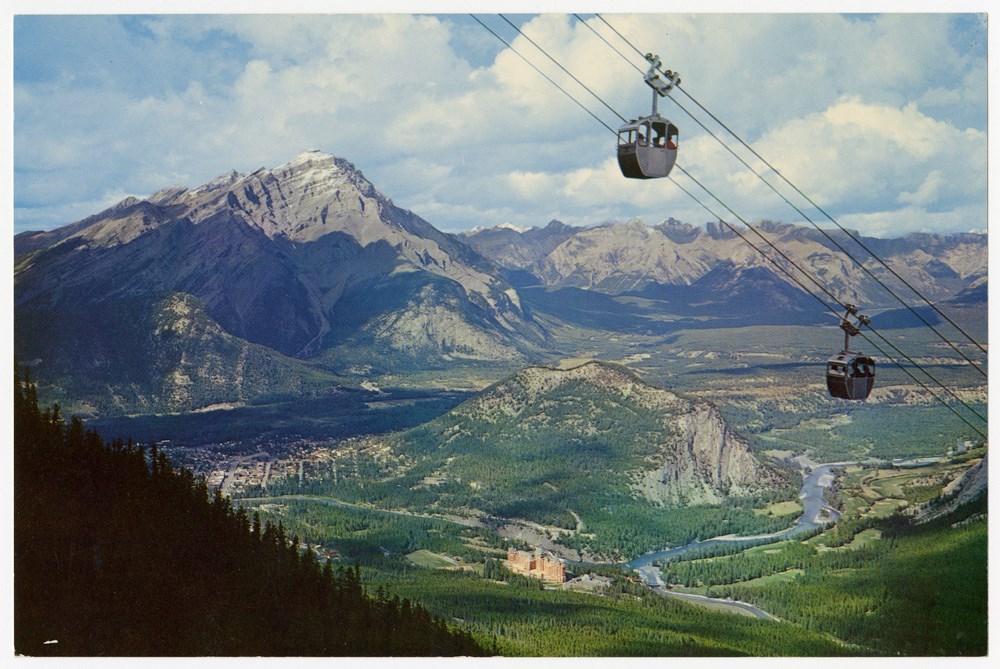
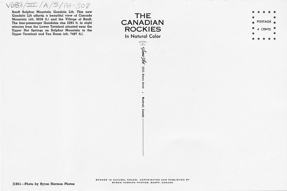
Banff Sulphur Mountain Gondola Lift
https://archives.whyte.org/en/permalink/descriptions51669
- Part Of
- Peter and Catharine Whyte fonds
- Scope & Content
- Image of the Sulphur Mountain gondola with the townsite, Tunnel Mountain, and Cascade Mountain in the background - title and details on the back
- Date Range
- [ca. 1940-1960]
- Reference Code
- V683 / III / A / 5 / PA - 308
- Description Level
- 6 / Image
- GMD
- Postcard
2 images
- Part Of
- Peter and Catharine Whyte fonds
- Description Level
- 6 / Image
- Fonds Number
- M36 / V683 / S37
- Series
- V683 / III / A / 5 : Peter and Catharine Whyte: Landscapes
- Sous-Fonds
- V683
- Accession Number
- .
- Reference Code
- V683 / III / A / 5 / PA - 308
- GMD
- Postcard
- Date Range
- [ca. 1940-1960]
- Physical Description
- Photograph: 1 print (front and back) ; b&w.
- Scope & Content
- Image of the Sulphur Mountain gondola with the townsite, Tunnel Mountain, and Cascade Mountain in the background - title and details on the back
- Subject Access
- Banff townsite
- Banff Springs Hotel
- Gondolas
- Mountains
- Geographic Access
- Banff
- Language
- English
- Title Source
- Title based on item
- Processing Status
- Processed
Images
This material is presented as originally created; it may contain outdated cultural descriptions and
potentially offensive content.
Read more.
Banff townsite
https://archives.whyte.org/en/permalink/descriptions51635
- Part Of
- Peter and Catharine Whyte fonds
- Scope & Content
- Image of the Banff townsite taken from Sulphur Mountain
- Date Range
- [ca. 1940-1960]
- Reference Code
- V683 / III / A / 5 / PA - 264
- Description Level
- 6 / Image
- GMD
- Photograph
1 image
- Part Of
- Peter and Catharine Whyte fonds
- Description Level
- 6 / Image
- Fonds Number
- M36 / V683 / S37
- Series
- V683 / III / A / 5 : Peter and Catharine Whyte: Landscapes
- Sous-Fonds
- V683
- Accession Number
- .
- Reference Code
- V683 / III / A / 5 / PA - 264
- GMD
- Photograph
- Date Range
- [ca. 1940-1960]
- Physical Description
- Photograph: 1 print ; b&w.
- Scope & Content
- Image of the Banff townsite taken from Sulphur Mountain
- Subject Access
- Banff townsite
- Buildings
- Geographic Access
- Banff
- Language
- English
- Title Source
- Title based on item
- Processing Status
- Processed
Images

This material is presented as originally created; it may contain outdated cultural descriptions and
potentially offensive content.
Read more.
Banff townsite from Sulphur Mountain
https://archives.whyte.org/en/permalink/descriptions51637
- Part Of
- Peter and Catharine Whyte fonds
- Scope & Content
- Image of the town of Banff with Rundle Mountain in the background - taken from Sulphur Mountain
- Date Range
- [ca. 1940-1960]
- Reference Code
- V683 / III / A / 5 / PA - 266
- Description Level
- 6 / Image
- GMD
- Photograph
1 image
- Part Of
- Peter and Catharine Whyte fonds
- Description Level
- 6 / Image
- Fonds Number
- M36 / V683 / S37
- Series
- V683 / III / A / 5 : Peter and Catharine Whyte: Landscapes
- Sous-Fonds
- V683
- Accession Number
- .
- Reference Code
- V683 / III / A / 5 / PA - 266
- GMD
- Photograph
- Date Range
- [ca. 1940-1960]
- Physical Description
- Photograph: 1 print ; b&w.
- Scope & Content
- Image of the town of Banff with Rundle Mountain in the background - taken from Sulphur Mountain
- Subject Access
- Banff townsite
- Buildings
- Geographic Access
- Banff
- Language
- English
- Title Source
- Title based on item
- Processing Status
- Processed
Images

This material is presented as originally created; it may contain outdated cultural descriptions and
potentially offensive content.
Read more.
Banff townsite in winter
https://archives.whyte.org/en/permalink/descriptions51611
- Part Of
- Peter and Catharine Whyte fonds
- Scope & Content
- Image of the Banff townsite at the base of Tunnel Mountain - possibly taken from Mt. Norquay
- Date Range
- [ca. 1940-1960]
- Reference Code
- V683 / III / A / 5 / PA - 240
- Description Level
- 6 / Image
- GMD
- Photograph
1 image
- Part Of
- Peter and Catharine Whyte fonds
- Description Level
- 6 / Image
- Fonds Number
- M36 / V683 / S37
- Series
- V683 / III / A / 5 : Peter and Catharine Whyte: Landscapes
- Sous-Fonds
- V683
- Accession Number
- .
- Reference Code
- V683 / III / A / 5 / PA - 240
- GMD
- Photograph
- Date Range
- [ca. 1940-1960]
- Physical Description
- Photograph: 1 print ; b&w.
- Scope & Content
- Image of the Banff townsite at the base of Tunnel Mountain - possibly taken from Mt. Norquay
- Subject Access
- Banff townsite
- Buildings
- Geographic Access
- Banff
- Language
- English
- Title Source
- Title based on item
- Processing Status
- Processed
Images

This material is presented as originally created; it may contain outdated cultural descriptions and
potentially offensive content.
Read more.
Banff-Windermere Highway and bridge
https://archives.whyte.org/en/permalink/descriptions51560
- Part Of
- Peter and Catharine Whyte fonds
- Scope & Content
- Image of a small bridge over the Bow River linking the original highway to the new unpaved Banff-Windermere Highway
- Date Range
- [ca. 1940-1960]
- Reference Code
- V683 / III / A / 5 / PA - 188
- Description Level
- 6 / Image
- GMD
- Photograph
1 image
- Part Of
- Peter and Catharine Whyte fonds
- Description Level
- 6 / Image
- Fonds Number
- M36 / V683 / S37
- Series
- V683 / III / A / 5 : Peter and Catharine Whyte: Landscapes
- Sous-Fonds
- V683
- Accession Number
- .
- Reference Code
- V683 / III / A / 5 / PA - 188
- GMD
- Photograph
- Date Range
- [ca. 1940-1960]
- Physical Description
- Photograph: 1 print ; b&w.
- Scope & Content
- Image of a small bridge over the Bow River linking the original highway to the new unpaved Banff-Windermere Highway
- Subject Access
- Banff-Windermere Highway
- Bridges
- Mountains
- Roads
- Geographic Access
- Banff National Park
- Language
- English
- Title Source
- Title based on item
- Processing Status
- Processed
Images

This material is presented as originally created; it may contain outdated cultural descriptions and
potentially offensive content.
Read more.
- Part Of
- Peter and Catharine Whyte fonds
- Scope & Content
- Image of a black bear sitting by the base of a tree - a building is visible behind more trees in the background
- Date Range
- [ca. 1940-1960]
- Reference Code
- V683 / III / A / 5 / PA - 184
- Description Level
- 6 / Image
- GMD
- Photograph
1 image
- Part Of
- Peter and Catharine Whyte fonds
- Description Level
- 6 / Image
- Fonds Number
- M36 / V683 / S37
- Series
- V683 / III / A / 5 : Peter and Catharine Whyte: Landscapes
- Sous-Fonds
- V683
- Accession Number
- .
- Reference Code
- V683 / III / A / 5 / PA - 184
- GMD
- Photograph
- Date Range
- [ca. 1940-1960]
- Physical Description
- Photograph: 1 print ; b&w.
- Scope & Content
- Image of a black bear sitting by the base of a tree - a building is visible behind more trees in the background
- Subject Access
- Animals
- Bears
- Black Bears
- Wildlife
- Geographic Access
- Banff
- Language
- English
- Title Source
- Title based on item
- Processing Status
- Processed
Images

This material is presented as originally created; it may contain outdated cultural descriptions and
potentially offensive content.
Read more.
- Part Of
- Peter and Catharine Whyte fonds
- Scope & Content
- Image of two small black bears around the corner of a stone building - possibly the Whyte house - trees throughout
- Date Range
- [ca. 1940-1960]
- Reference Code
- V683 / III / A / 5 / PA - 179
- Description Level
- 6 / Image
- GMD
- Photograph
1 image
- Part Of
- Peter and Catharine Whyte fonds
- Description Level
- 6 / Image
- Fonds Number
- M36 / V683 / S37
- Series
- V683 / III / A / 5 : Peter and Catharine Whyte: Landscapes
- Sous-Fonds
- V683
- Accession Number
- .
- Reference Code
- V683 / III / A / 5 / PA - 179
- GMD
- Photograph
- Date Range
- [ca. 1940-1960]
- Physical Description
- Photograph: 1 print ; b&w.
- Scope & Content
- Image of two small black bears around the corner of a stone building - possibly the Whyte house - trees throughout
- Subject Access
- Animals
- Bears
- Black Bears
- Wildlife
- Language
- English
- Title Source
- Title based on item
- Processing Status
- Processed
Images

This material is presented as originally created; it may contain outdated cultural descriptions and
potentially offensive content.
Read more.