Narrow Results By
[Personal photographs]
https://archives.whyte.org/en/permalink/descriptions23836
- Part Of
- Luxton family fonds
- Scope & Content
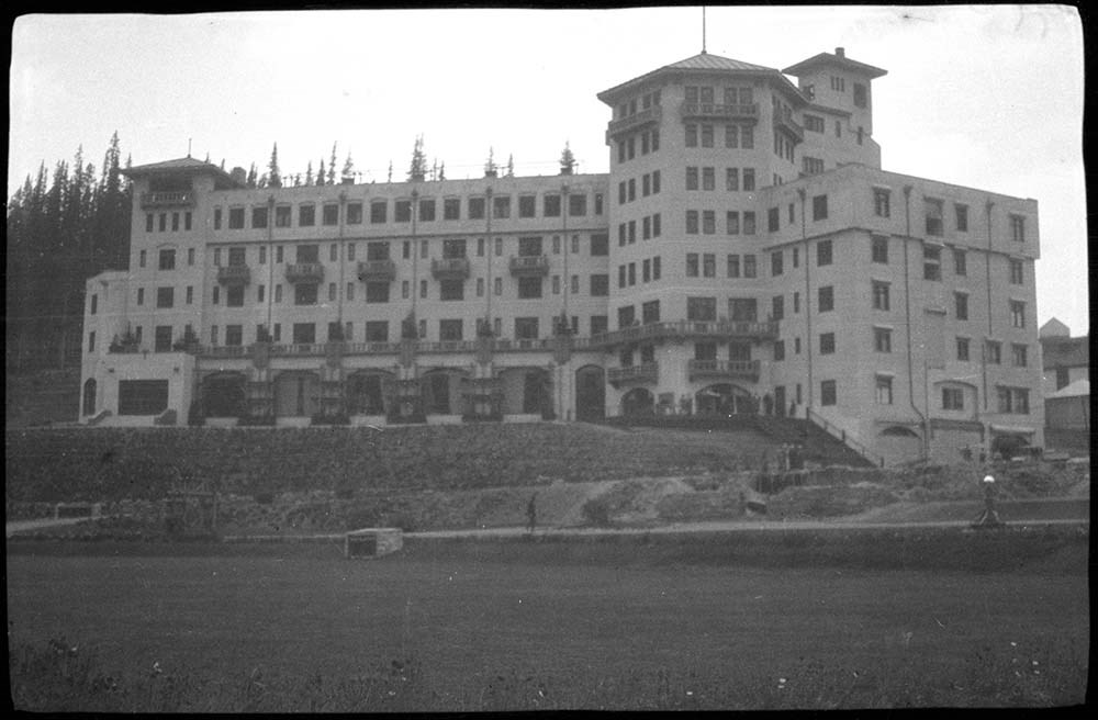
- File consists of negatives depicting big horn sheep, canyons, Chateau Lake Louise, the Luxton House and garden.
- Date Range
- [1940-1960]
- Reference Code
- LUX / I / E4 / NA - 49 to NA - 53
- Description Level
- 5 / File
- GMD
- Photograph
- Negative
5 images
- Part Of
- Luxton family fonds
- Description Level
- 5 / File
- Fonds Number
- LUX
- Series
- LUX / I / E : Collected Material
- Sous-Fonds
- LUX / I : Norman Luxton sous-fonds
- Sub-Series
- LUX / I / E / 4 : Photographs
- Reference Code
- LUX / I / E4 / NA - 49 to NA - 53
- GMD
- Photograph
- Negative
- Date Range
- [1940-1960]
- Physical Description
- 5 photographs: b&w negatives ; 7.5 x 4.5 cm
- Scope & Content
- File consists of negatives depicting big horn sheep, canyons, Chateau Lake Louise, the Luxton House and garden.
- Subject Access
- Chateau Lake Louise
- Lake Louise
- Big Horn
- Big Horn Sheep
- Geographic Access
- Banff
- Banff National Park
- Lake Louise
- Processing Status
- Processed
Images


This material is presented as originally created; it may contain outdated cultural descriptions and
potentially offensive content.
Read more.
[Baffin Island 37E/8E] Bieler Lake East, District of Franklin, Northwest Territories
https://archives.whyte.org/en/permalink/catalogue23471
- Medium
- Library - Maps and blueprints (unannotated; published)
- Map
- Published Date
- 1964
- Publisher
- Department of Mines and Technical Surveys
- Call Number
- NTS
- 37E/8E
- Publisher
- Department of Mines and Technical Surveys
- Published Date
- 1964
- Physical Description
- 1 map : black and white
- Scale
- Scale: 1:50,000
- Relief: Contour intervals
- Notes
- Arctic provisional map
- National Topographic System
- Accession Number
- 7000
- Call Number
- NTS
- 37E/8E
- Collection
- Archives Library
This material is presented as originally created; it may contain outdated cultural descriptions and
potentially offensive content.
Read more.
[Baffin Island 37E/8W] Bieler Lake East, District of Franklin, Northwest Territories
https://archives.whyte.org/en/permalink/catalogue23472
- Medium
- Library - Maps and blueprints (unannotated; published)
- Map
- Published Date
- 1964
- Publisher
- Department of Mines and Technical Surveys
- Call Number
- NTS
- 37E/8E
- Publisher
- Department of Mines and Technical Surveys
- Published Date
- 1964
- Physical Description
- 1 map : black and white
- Scale
- Scale: 1:50,000
- Relief: Contour intervals
- Notes
- Arctic provisional map
- National Topographic System
- Accession Number
- 7000
- Call Number
- NTS
- 37E/8E
- Collection
- Archives Library
This material is presented as originally created; it may contain outdated cultural descriptions and
potentially offensive content.
Read more.
[Baffin Island, Bieler Lake East] District of Franklin, Northwest Territories
https://archives.whyte.org/en/permalink/catalogue23473
- Medium
- Library - Maps and blueprints (unannotated; published)
- Map
- Published Date
- 1964
- Publisher
- Department of Mines and Technical Surveys
- Call Number
- NTS
- 37E/8W
- Publisher
- Department of Mines and Technical Surveys
- Published Date
- 1964
- Physical Description
- 1 map : black and white
- Scale
- Scale: 1:50,000
- Relief: Contour intervals
- Notes
- National Topographic System
- Arctic provisional map
- Accession Number
- 7000
- Call Number
- NTS
- 37E/8W
- Collection
- Archives Library
This material is presented as originally created; it may contain outdated cultural descriptions and
potentially offensive content.
Read more.
[Baffin Island, Bieler Lake West, Barnes Ice Cap 37E/7E] District of Franklin, Northwest Territories
https://archives.whyte.org/en/permalink/catalogue23469
- Medium
- Library - Maps and blueprints (unannotated; published)
- Map
- Published Date
- 1964
- Publisher
- Department of Mines and Technical Surveys
- Call Number
- NTS
- 37E/7E
- Publisher
- Department of Mines and Technical Surveys
- Published Date
- 1964
- Physical Description
- 1 map : black and white
- Scale
- Scale: 1:50,000
- Relief: Contour intervals
- Subjects
- Baffin Island, Bieler Lake West, Barnes Ice Cap
- District of Franklin, Northwest Territories
- Notes
- National Topographic System
- Accession Number
- 7000
- Call Number
- NTS
- 37E/7E
- Collection
- Archives Library
This material is presented as originally created; it may contain outdated cultural descriptions and
potentially offensive content.
Read more.
[Baffin Island, Bieler Lake West, Barnes Ice Cap 37E/7W] District of Franklin, Northwest Territories
https://archives.whyte.org/en/permalink/catalogue23470
- Medium
- Library - Maps and blueprints (unannotated; published)
- Map
- Published Date
- 1964
- Publisher
- Department of Mines and Technical Surveys
- Call Number
- NTS
- 37E/7W
- Publisher
- Department of Mines and Technical Surveys
- Published Date
- 1964
- Physical Description
- 1 map : black and white
- Scale
- Scale: 1:50,000
- Relief: Contour intervals
- Subjects
- Baffin Island, Bieler Lake West, Barnes Ice Cap
- District of Franklin, Northwest Territories
- Notes
- National Topographic System
- Arctic provisional map
- Accession Number
- 7000
- Call Number
- NTS
- 37E/7W
- Collection
- Archives Library
This material is presented as originally created; it may contain outdated cultural descriptions and
potentially offensive content.
Read more.
Banff National Park and Lake Louise maps
https://archives.whyte.org/en/permalink/descriptions54945
- Scope & Content
- File consists of two folded maps and a small clipping [possibly top or bottom portion from a different map or one of maps in file]. One map is of Banff National Park and one is of Lake Louise [1959]. Banff National Park map has black pencil tracings over trail section near the bottom of the map and…
- Date Range
- 1959
- [1960-1970]
- Reference Code
- M545 / V / 53
- Description Level
- 5 / File
- GMD
- Textual record
- Published record
- Map
- Description Level
- 5 / File
- Fonds Number
- M545 / V635
- Series
- M545 / V : Administrative records
- Sous-Fonds
- M545
- Accession Number
- 8235
- Reference Code
- M545 / V / 53
- Date Range
- 1959
- [1960-1970]
- Physical Description
- 0.5 cm of textual records (2 maps ; 60.5 x 57.5 and 60 x 56.5 cm)
- Scope & Content
- File consists of two folded maps and a small clipping [possibly top or bottom portion from a different map or one of maps in file]. One map is of Banff National Park and one is of Lake Louise [1959]. Banff National Park map has black pencil tracings over trail section near the bottom of the map and annotation in bottom right corner which reads "Natural Bridge". Lake Louise map produced by the Government of Canada.
- Subject Access
- Banff National Park
- Environment
- Geography
- Map
- Lake Louise
- Travel
- Government
- National parks and reserves
- Trails
- Geographic Access
- Canada
- Alberta
- Banff National Park
- Lake Louise
- Language
- English
- Conservation
- Clipping stored in mylar due to significant staining and residue from tape
- Items kept folded [not placed in mylar] due to mass production of content and minimal/no annotations
- Title Source
- Title based on contents of file
- Processing Status
- Processed
This material is presented as originally created; it may contain outdated cultural descriptions and
potentially offensive content.
Read more.
[Barriere Lakes 82M/5 East, B.C.]
https://archives.whyte.org/en/permalink/catalogue23482
- Medium
- Library - Maps and blueprints (unannotated; published)
- Map
- Published Date
- 1962
- Publisher
- Department of Mines and Technical Surveys
- Call Number
- NTS
- 82M/5E
- Publisher
- Department of Mines and Technical Surveys
- Published Date
- 1962
- Physical Description
- 1 map : col
- Scale
- Scale: 1:50,000
- Relief: Contour interval 100 ft.
- Subjects
- Barriere Lake
- British Columbia
- Notes
- National Topographic System
- Accession Number
- 7000
- Call Number
- NTS
- 82M/5E
- Collection
- Archives Library
This material is presented as originally created; it may contain outdated cultural descriptions and
potentially offensive content.
Read more.
[Bonaparte Lake 92P, B.C.]
https://archives.whyte.org/en/permalink/catalogue24009
- Medium
- Library - Maps and blueprints (unannotated; published)
- Map
- Published Date
- 1969
- Publisher
- Department of Energy, Mines and Resources
- Call Number
- NTS
- 92P
- Publisher
- Department of Energy, Mines and Resources
- Published Date
- 1969
- Physical Description
- 1 map : col
- Scale
- Scale: 1:250,000
- Relief: Contour interval 500 ft.
- Subjects
- Bonaparte Lake
- British Columbia
- Notes
- National Topographic System
- Accession Number
- 5500
- Call Number
- NTS
- 92P
- Collection
- Archives Library
This material is presented as originally created; it may contain outdated cultural descriptions and
potentially offensive content.
Read more.
B.S. Hotel "Oldies", B.S. Hotel Golf, Balfour Glacier, Timberline Hotel, Lake Louise "Oldies"
https://archives.whyte.org/en/permalink/descriptions54298
- Part Of
- Nicholas Morant fonds
- Scope & Content
- File consists of 23 negative photographs (colour and b&w), 30 colour transparencies and 1 colour print. Content pertains to Banff National Park AB views. Includes Balfour Glacier, Hector Lake, Bow Lake, Banff Springs Hotel, Banff Springs Hotel golf course, views from Chateau Lake Louise (1960s), Ti…
- Date Range
- [ca. 1960 - ca. 1970] [ca. 1965]
- Reference Code
- V500 / I / A7 / 30
- Description Level
- 4.2 / Sub-sub-sub series
- GMD
- Photograph
- Negative
- Transparency
- Part Of
- Nicholas Morant fonds
- Description Level
- 4.2 / Sub-sub-sub series
- Fonds Number
- M300 / S20 / V500
- Sous-Fonds
- V500
- Sub-Series
- V500 / I / A : Negatives and Transparencies
- Accession Number
- 7438
- Reference Code
- V500 / I / A7 / 30
- Responsibility
- Nicholas Morant
- Date Range
- [ca. 1960 - ca. 1970] [ca. 1965]
- Physical Description
- 54 Photographs: negatives, transparencies, print; b&w and colour
- Scope & Content
- File consists of 23 negative photographs (colour and b&w), 30 colour transparencies and 1 colour print. Content pertains to Banff National Park AB views. Includes Balfour Glacier, Hector Lake, Bow Lake, Banff Springs Hotel, Banff Springs Hotel golf course, views from Chateau Lake Louise (1960s), Timberline Hotel, Banff. Print photograph depicts bagpipe player near Banff Springs Hotel.
- Notes
- Contains duplicates. Negatives, transparencies and print stored in separate file boxes.
- Subject Access
- Banff National Park
- Banff Springs Hotel
- Chateau Lake Louise
- Hotel
- tourism
- Geographic Access
- Canada
- Alberta
- Banff
- Reproduction Restrictions
- Reference use only; no reproduction
- Language
- English
- Creator
- Nicholas Morant
- Title Source
- Title based on contents of file
- Processing Status
- Processed
This material is presented as originally created; it may contain outdated cultural descriptions and
potentially offensive content.
Read more.