Narrow Results By
Calgary Mountain Club fonds
https://archives.whyte.org/en/permalink/descriptions57638
- Part Of
- Calgary Mountain Club fonds
- Scope & Content
- Fonds consists of records pertaining to the Calgary Mountain Club. Fonds includes two volumes of club meeting minutes, 1960-1987; one financial ledger book, 1964-1980; bound volume containing the club's constitution, route descriptions, photographs, and related content from various expeditions; one…
- Date Range
- 1960-1987
- Reference Code
- M338
- V821
- Description Level
- 1 / Fonds
- GMD
- Organization record
- Photograph
- Published record
- Textual record
- Part Of
- Calgary Mountain Club fonds
- Description Level
- 1 / Fonds
- Fonds Number
- M338
- V821
- Sous-Fonds
- M338
- V821
- Accession Number
- 6772
- 2023.64
- Reference Code
- M338
- V821
- Responsibility
- Materials produced by CMC
- Date Range
- 1960-1987
- Physical Description
- 7 bound volumes -- two mounted b&w prints : 28 x 35 cm -- 3 cm textual records
- History / Biographical
- The Calgary Mountain Club (CMC) is Calgary's oldest mountaineering organization that is dedicated specifically to the furtherance of hard climbing objectives on significant peaks. These peaks are predominantly in the Canadian Rockies, but in many cases extend to significant mountain ranges throughout North America and Europe. The CMC was founded in 1960 and is still an active club as of 2023. Chic Scott's publication, "History of the Calgary Mountain Club" (1988) provides a detailed summary of the club's early history.
- Scope & Content
- Fonds consists of records pertaining to the Calgary Mountain Club. Fonds includes two volumes of club meeting minutes, 1960-1987; one financial ledger book, 1964-1980; bound volume containing the club's constitution, route descriptions, photographs, and related content from various expeditions; one copy of Chic Scott's publication, "History of the Calgary Mountain Club" (1988); registers for Archie Simpson Hut (1972-1974) and Castle Mountain Hut (1967-1984); two mounted black & white prints depicting the Graham Cooper Hut and Black Rock Needle; memorial booklet for Archie Simpson; and one folder of loose textual records including correspondence, pamphlets, administrative documents, and related materials.
- Name Access
- Calgary Mountain Club
- Subject Access
- Calgary Mountain Club
- Climbing
- Club
- Mountaineering
- Hiking
- Exploration
- Organizations
- Recreation
- Sports
- Geographic Access
- Canada
- Alberta
- Calgary
- Canadian Rocky Mountains
- Language
- English
- Related Material
- Chic Scott fonds: Calgary Mountain Club series (M57 / XII and V40 / XII)
- Biographical Source Notes
- Information provided by Ken Wiens
- Title Source
- Title based on contents of fonds
- Processing Status
- Processed
This material is presented as originally created; it may contain outdated cultural descriptions and
potentially offensive content.
Read more.
Banff National Park (general)
https://archives.whyte.org/en/permalink/descriptions55338
- Part Of
- Murray Hay fonds
- Scope & Content
- File consists of 4 prings : col. 35.1 x 24.8 cm or smaller and 4 maps (2 paper, 2 overlays) : col., on mylar ; 60.4 x 30. cm or smaller. File pertains to aerial views of Banff National Park, showing the towns of Banff and Lake Louise, ski hills (Norqay Ski Hill, Sunshine Village, and Lake Louise Sk…
- Date Range
- ca.1976-ca.2000
- Reference Code
- V795 / II / B / v / 1-2
- Description Level
- 5 / File
- GMD
- Map
- Private record
- Part Of
- Murray Hay fonds
- Description Level
- 5 / File
- Fonds Number
- M570 / V795
- Series
- V795 / II : Unpublished Material
- Sous-Fonds
- V795
- Sub-Series
- V795 / II / B : Alberta / v : Banff National Park
- Accession Number
- 2019.41
- Reference Code
- V795 / II / B / v / 1-2
- GMD
- Map
- Private record
- Date Range
- ca.1976-ca.2000
- Physical Description
- 4 prints : col. 35.1 x 24.8 cm or smaller
- 4 maps (2 paper, 2 overlays) : col., annotations, on mylar ; 60.4 x 30. cm or smaller
- Scope & Content
- File consists of 4 prings : col. 35.1 x 24.8 cm or smaller and 4 maps (2 paper, 2 overlays) : col., on mylar ; 60.4 x 30. cm or smaller. File pertains to aerial views of Banff National Park, showing the towns of Banff and Lake Louise, ski hills (Norqay Ski Hill, Sunshine Village, and Lake Louise Ski Resort), as well as other georgraphic features. The mylar overlays contain various amounts of detail and annotations - one consists of a dark red sheet overlayed with place names in negative.
- Notes
- Items not in oversize stored in downstairs vault.
- Name Access
- Hay, Murray
- Subject Access
- Advertising
- Artist
- Ski Maps
- Map
- Cartography
- Sports and recreation
- Tourism
- Tourist information
- Winter
- Winter sports
- Ski area
- Sunshine Village
- Norquay Ski Hill
- Lake Louise Ski Area
- Geographic Access
- Banff
- Lake Louise
- Banff National Park
- Alberta
- Canada
- Canadian Rocky Mountains
- Language
- English
- Creator
- Hay, Murray
- Title Source
- Title based on contents of file
- Processing Status
- Processed
This material is presented as originally created; it may contain outdated cultural descriptions and
potentially offensive content.
Read more.
Calgary Olympic Bid 1988
https://archives.whyte.org/en/permalink/descriptions54946
- Part Of
- Murray Hay fonds
- Scope & Content
- File consists of 10 prints : col. ; 64 x 61 cm or smaller. File pertains to Murray Hay's participation in Calgary's Olympic Bid in the early 1980s. File includes a variety of different reproduced draft maps depciting Calgary and Canada Olympic Park, Banff National Park, Kananaskis, Spray Valley, et…
- Date Range
- ca.1980-ca.1981
- Reference Code
- V795 / II / B / iv / 1-2
- Description Level
- 5 / File
- GMD
- Map
- Private record
- Part Of
- Murray Hay fonds
- Description Level
- 5 / File
- Fonds Number
- M570 / V795
- Series
- V795 / II : Unpublished Material
- Sous-Fonds
- V795
- Sub-Series
- V795 / II / B : Alberta / iv : Olympic Bid
- Accession Number
- 2019.41
- Reference Code
- V795 / II / B / iv / 1-2
- GMD
- Map
- Private record
- Date Range
- ca.1980-ca.1981
- Physical Description
- 10 prints : col. ; 64 x 61 cm or smaller
- Scope & Content
- File consists of 10 prints : col. ; 64 x 61 cm or smaller. File pertains to Murray Hay's participation in Calgary's Olympic Bid in the early 1980s. File includes a variety of different reproduced draft maps depciting Calgary and Canada Olympic Park, Banff National Park, Kananaskis, Spray Valley, etc.
- Notes
- Date range is approximate. The Olympic Bid was selected in 1981.
- One print depicting the City of Calgary with the Canadian Rockies in the background has a note taped to it that reads: "A view from Calgary to Banff showing Olympic sites for 1988 winter games (proximity exaggerated."
- Name Access
- Hay, Murray
- Subject Access
- Artist
- Ski Maps
- Map
- Cartography
- Sports and recreation
- Tourism
- Winter
- Winter sports
- Olympic Games (Winter)
- Geographic Access
- Calgary
- Banff National Park
- Alberta
- Canada
- Canadian Rocky Mountains
- Canada Olympic Park
- Spray Lakes
- Spray Valley
- Bow Valley
- Kananaskis
- Bragg Creek
- Canmore
- Language
- English
- Conservation
- V795 / II / B / iv / 2 : Masking tape should be removed and alternative preservation methods should be considered at a reasonable time to do so.
- Related Material
- M570 / III / C / i / 1
- Creator
- Hay, Murray
- Title Source
- Title based on contents of file
- Processing Status
- Processed
This material is presented as originally created; it may contain outdated cultural descriptions and
potentially offensive content.
Read more.
Fernie Alpine Resort
https://archives.whyte.org/en/permalink/descriptions54883
- Part Of
- Murray Hay fonds
- Scope & Content
- File consists of 2 maps (1 base, 4 overlays) : col., annotations, on mylar ; 32 x 27 cm and 30 x 22 cm, and 2 prints : col. ; 35 x 28 cm. File pertains to Murray Hay's rendering of the ski hill at Fernie, British Columbia. File includes two reproduced drafts with mylar overlays (one held together b…
- Date Range
- ca.1977-ca.1997
- Reference Code
- V795 / II / A / vi / 1-2
- Description Level
- 5 / File
- GMD
- Map
- Private record
- Part Of
- Murray Hay fonds
- Description Level
- 5 / File
- Fonds Number
- M570 / V795
- Series
- V795 / II : Unpublished Material
- Sous-Fonds
- V795
- Sub-Series
- V795 / II / A : British Columbia / vi : Fernie
- Accession Number
- 2019.41
- Reference Code
- V795 / II / A / vi / 1-2
- GMD
- Map
- Private record
- Date Range
- ca.1977-ca.1997
- Physical Description
- 2 maps (1 base, 4 overlays) : col., annotations, on mylar ; 32 x 27 cm and 30 x 22 cm
- 2 prints : col. ; 35 x 28 cm
- Scope & Content
- File consists of 2 maps (1 base, 4 overlays) : col., annotations, on mylar ; 32 x 27 cm and 30 x 22 cm, and 2 prints : col. ; 35 x 28 cm. File pertains to Murray Hay's rendering of the ski hill at Fernie, British Columbia. File includes two reproduced drafts with mylar overlays (one held together by tape or glue, the other by masking tape), and two reproduced draft prints of the ski area.
- Notes
- Date range is approximate. The Timberland sub-division was developed between 1981-1991. The resort was known as Fernie Snow Valley until 1997.
- Name Access
- Hay, Murray
- Subject Access
- Advertising
- Art
- Artist
- Ski Maps
- Cartography
- Sports and recreation
- Tourism
- Tourist information
- Winter
- Winter sports
- Ski area
- Geographic Access
- Fernie
- British Columbia
- Canada
- Canadian Rocky Mountains
- Language
- English
- Conservation
- Masking tape should be removed and alternative preservation methods should be considered at a reasonable time to do so.
- Creator
- Hay, Murray
- Title Source
- Title based on contents of file
- Processing Status
- Processed
This material is presented as originally created; it may contain outdated cultural descriptions and
potentially offensive content.
Read more.
Geology photos for geological views
https://archives.whyte.org/en/permalink/descriptions55990
- Part Of
- Ben Gadd fonds
- Scope & Content
- File consists of printed photographs compiled by Ben Gadd pertaining to his book, Handbook of the Canadian Rockies. Images depict mountain views; bighorn sheep posing on steep rock; and highway views, possibly including Icefields Parkway.
- Date Range
- [ca.1990-1995]
- Reference Code
- V810 / II / A / PA - 40 to 138
- Description Level
- 5 / File
- GMD
- Photograph
- Part Of
- Ben Gadd fonds
- Description Level
- 5 / File
- Fonds Number
- M590
- V810
- S61
- Series
- V810 / II : Research and publication records
- Sous-Fonds
- V810
- Sub-Series
- V810 / II / B : Handbook of the Canadian Rockies
- Accession Number
- 2021.20
- Reference Code
- V810 / II / A / PA - 40 to 138
- GMD
- Photograph
- Responsibility
- Produced by Ben Gadd
- Date Range
- [ca.1990-1995]
- Physical Description
- 99 photographs : col. prints ; 15 x 10 cm
- Scope & Content
- File consists of printed photographs compiled by Ben Gadd pertaining to his book, Handbook of the Canadian Rockies. Images depict mountain views; bighorn sheep posing on steep rock; and highway views, possibly including Icefields Parkway.
- Material Details
- Photographs were originally stored in Tekarra Color Lab envelope
- Subject Access
- Publication
- Landscapes
- Travel
- Roads
- Wildlife
- Bighorn Sheep
- Mountains
- Geology
- Environment
- Natural history
- Geographic Access
- Canada
- Alberta
- Columbia Icefield
- Jasper National Park
- Canadian Rocky Mountains
- Reproduction Restrictions
- Restrictions may apply
- Language
- English
- Title Source
- Original title used
- Processing Status
- Processed
This material is presented as originally created; it may contain outdated cultural descriptions and
potentially offensive content.
Read more.
HCR info files - Geomorphology and Pleistocene
https://archives.whyte.org/en/permalink/descriptions55957
- Part Of
- Ben Gadd fonds
- Scope & Content
- File consists of published research material collected by Ben Gadd pertaining to the study of Geomorphology and the Pleistocene Epoch. File includes one photograph print sent to Ben Gadd depicting a boulder [in file M590/II/A/32].
- Date Range
- 1958
- 1966-1967
- 1973-1989
- 1991-1995
- 2004
- 2007-2010
- Reference Code
- M590 / II / A / 32 to 37
- Description Level
- 5 / File
- GMD
- Textual record
- Published record
- Photograph
- Part Of
- Ben Gadd fonds
- Description Level
- 5 / File
- Fonds Number
- M590
- V810
- S61
- Series
- M590 / II : Research and publication records
- Sous-Fonds
- M590
- Sub-Series
- M590 / II / A : Handbook of the Canadian Rockies
- Accession Number
- 2021.20
- Reference Code
- M590 / II / A / 32 to 37
- Responsibility
- Photograph produced by Alan Kane, 1994
- Date Range
- 1958
- 1966-1967
- 1973-1989
- 1991-1995
- 2004
- 2007-2010
- Physical Description
- 12 cm of textual records -- 1 photograph : col. print
- Scope & Content
- File consists of published research material collected by Ben Gadd pertaining to the study of Geomorphology and the Pleistocene Epoch. File includes one photograph print sent to Ben Gadd depicting a boulder [in file M590/II/A/32].
- Storage Range
- Materials stored in two file boxes: M590/II/A/26 to 32 and M590/II/A/33 to 38
- Name Access
- Gadd, Ben
- Subject Access
- Publication
- Research
- Natural history
- Environment
- Geology
- Geographic Access
- Canada
- Canadian Rocky Mountains
- Reproduction Restrictions
- Copyright restrictions may apply
- Language
- English
- Category
- Environment
- Title Source
- Title based on contents of file
- Processing Status
- Processed
This material is presented as originally created; it may contain outdated cultural descriptions and
potentially offensive content.
Read more.
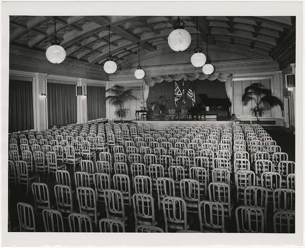
Hotels 1, hotel extras 1
https://archives.whyte.org/en/permalink/descriptions21590
- Part Of
- Nicholas Morant fonds
- Scope & Content
- File pertains to Canadian Pacific Railway hotels, specifically the Chateau Frontenac, Quebec City; Royal York Hotel, Toronto; Hotel Saskatchewan, Regina; Banff Springs Hotel, Alberta; Chateau Lake Louise, Alberta; Empress Hotel, Victoria; and Empress Hotel Motor Lodge, Victoria. Includes labelled …
- Date Range
- [between 1930 and 1980]
- Reference Code
- V500 / C1 / 36 to 39
- Description Level
- 5 / File
- GMD
2 images
- Part Of
- Nicholas Morant fonds
- Description Level
- 5 / File
- Fonds Number
- M300 / S20 / V500
- Series
- I.C. Photography : prints
- Sous-Fonds
- V500
- Reference Code
- V500 / C1 / 36 to 39
- GMD
- Date Range
- [between 1930 and 1980]
- Physical Description
- 121 photographs : prints, b/w
- Scope & Content
- File pertains to Canadian Pacific Railway hotels, specifically the Chateau Frontenac, Quebec City; Royal York Hotel, Toronto; Hotel Saskatchewan, Regina; Banff Springs Hotel, Alberta; Chateau Lake Louise, Alberta; Empress Hotel, Victoria; and Empress Hotel Motor Lodge, Victoria. Includes labelled set: BSH public rooms 1966, 2 items (folder 38)
- Geographic Access
- Alberta
- British Columbia
- Ontario
- Quebec
- Saskatchewan
- Processing Status
- Processed
Images
This material is presented as originally created; it may contain outdated cultural descriptions and
potentially offensive content.
Read more.
Illustrations - geo
https://archives.whyte.org/en/permalink/descriptions55991
- Part Of
- Ben Gadd fonds
- Scope & Content
- File consists of photographs taken or collected by Ben Gadd pertaining to rock formations and other geological features near Meadow Creek and Miette in Jasper National Park. File also includes four photographs from Jim Aitken and the Geological Survey of Canada (Calgary, Ottawa).
- Date Range
- [ca.1990-1995]
- Reference Code
- V810 / II / A / PA - 139 to 162
- Description Level
- 5 / File
- GMD
- Photograph
- Textual record
- Part Of
- Ben Gadd fonds
- Description Level
- 5 / File
- Fonds Number
- M590
- V810
- S61
- Series
- V810 / II : Research and publication records
- Sous-Fonds
- V810
- Sub-Series
- V810 / II / A : Handbook of the Canadian Rockies
- Accession Number
- 2021.20
- Reference Code
- V810 / II / A / PA - 139 to 162
- Responsibility
- Produced by Ben Gadd, Jim Aitken, Geological Survey of Canada
- Date Range
- [ca.1990-1995]
- Physical Description
- 24 photographs : b&w and col. prints ; 20 x 15 cm or smaller
- Scope & Content
- File consists of photographs taken or collected by Ben Gadd pertaining to rock formations and other geological features near Meadow Creek and Miette in Jasper National Park. File also includes four photographs from Jim Aitken and the Geological Survey of Canada (Calgary, Ottawa).
- Notes
- Most photographs are annotated on back by Ben Gadd. Photos V810/II/A/PA-10 and 162 accompanied in file by corresponding notes/textual records
- Material Details
- Original storage envelopes (annotated) stored in folder with prints
- Name Access
- Gadd, Ben
- Subject Access
- Research
- Environment
- Geology
- Geological formation
- Geography
- Surveying
- Surveys
- Government
- Science and technology
- Geographic Access
- Canada
- Alberta
- Jasper National Park
- Miette
- Calgary
- Ontario
- Ottawa
- Reproduction Restrictions
- Restrictions may apply
- Language
- English
- Related Material
- Corresponding negative film [for V810/II/A/PA-139 to 158]: V810 / II / A / NA - 16 to 23
- Category
- Environment
- Science and technology
- Government
- Title Source
- Original title used
- Processing Status
- Processed
This material is presented as originally created; it may contain outdated cultural descriptions and
potentially offensive content.
Read more.
Lake Louise Area
https://archives.whyte.org/en/permalink/descriptions54925
- Part Of
- Murray Hay fonds
- Scope & Content
- File consists of 6 prints : col. ; 25.5 x 20 cm or smaller. File pertains to Murray Hay's renderings of the Lake Louise ski area. File includes six reproduced draft prints of original paintings of the Lake Louise ski area created by Murray Hay (different iterations).
- Date Range
- ca.1976-ca.2000
- Reference Code
- V795 / II / B / ii / 1
- Description Level
- 5 / File
- GMD
- Map
- Private record
- Part Of
- Murray Hay fonds
- Description Level
- 5 / File
- Fonds Number
- M570 / V795
- Series
- V795 / I : Unpublished Material
- Sous-Fonds
- V795
- Sub-Series
- V795 / I / B : Alberta / ii : Lake Louise
- Accession Number
- 2019.41
- Reference Code
- V795 / II / B / ii / 1
- GMD
- Map
- Private record
- Date Range
- ca.1976-ca.2000
- Physical Description
- 6 prints : col. ; 25.5 x 20 cm or smaller
- Scope & Content
- File consists of 6 prints : col. ; 25.5 x 20 cm or smaller. File pertains to Murray Hay's renderings of the Lake Louise ski area. File includes six reproduced draft prints of original paintings of the Lake Louise ski area created by Murray Hay (different iterations).
- Name Access
- Hay, Murray
- Subject Access
- Advertising
- Artist
- Ski Maps
- Map
- Cartography
- Sports and recreation
- Tourism
- Tourist information
- Winter
- Winter sports
- Ski area
- Lake Louise Ski Area
- Geographic Access
- Lake Louise
- Alberta
- Canada
- Canadian Rocky Mountains
- Language
- English
- Related Material
- M570 / III / B / ii / 1-2
- Creator
- Hay, Murray
- Title Source
- Title based on contents of file
- Processing Status
- Processed
This material is presented as originally created; it may contain outdated cultural descriptions and
potentially offensive content.
Read more.
- Part Of
- Murray Hay fonds
- Scope & Content
- File consists of 2 prints : col. ; 35 x 28 cm. File pertains to Murray Hay's rendering of Marmot Basin ski area in Jasper National Park. File includes two iterations of reproduction draft prints of Hay's map of Marmot Basin.
- Date Range
- ca.1976-ca.2000
- Reference Code
- V795 / II / B / i / 1
- Description Level
- 5 / File
- GMD
- Map
- Private record
- Part Of
- Murray Hay fonds
- Description Level
- 5 / File
- Fonds Number
- M570 / V795
- Series
- V795 / II : Unpublished Material
- Sous-Fonds
- V795
- Sub-Series
- V795 / II / B : Alberta / i : Jasper National Park
- Accession Number
- 2019.41
- Reference Code
- V795 / II / B / i / 1
- GMD
- Map
- Private record
- Date Range
- ca.1976-ca.2000
- Physical Description
- 2 prints : col. ; 35 x 28 cm
- Scope & Content
- File consists of 2 prints : col. ; 35 x 28 cm. File pertains to Murray Hay's rendering of Marmot Basin ski area in Jasper National Park. File includes two iterations of reproduction draft prints of Hay's map of Marmot Basin.
- Name Access
- Hay, Murray
- Subject Access
- Advertising
- Artist
- Ski Maps
- Ski area
- Map
- Cartography
- Sports and recreation
- Tourism
- Tourist information
- Winter
- Winter sports
- Geographic Access
- Jasper Marmot Basin
- Jasper National Park
- Alberta
- Canada
- Canadian Rocky Mountains
- Language
- English
- Related Material
- M570 / III / B / iii / 1
- Creator
- Hay, Murray
- Title Source
- Title based on contents of file
- Processing Status
- Processed
This material is presented as originally created; it may contain outdated cultural descriptions and
potentially offensive content.
Read more.