Narrow Results By
Construction, Banff-Windermere Higw
https://archives.whyte.org/en/permalink/descriptions57602
- Part Of
- Bruno Engler fonds
- Scope & Content
- Item consists of one 16 mm motion picture pertaining to construction of the Banff-Windermere Highway. Includes mostly footage of large construction machines grading and building the foundations of the highway, as well as drilling underneath the highway, presumably for drainage purposes. The origina…
- Date Range
- 1958
- Reference Code
- V190 / VI / NF - 24
- Description Level
- 6 / Item
- GMD
- Film
- Motion picture
1 image
- Part Of
- Bruno Engler fonds
- Description Level
- 6 / Item
- Fonds Number
- M323 / S40 / V190
- Series
- VI : Retained file
- Sous-Fonds
- V190
- Accession Number
- 7436
- Reference Code
- V190 / VI / NF - 24
- GMD
- Film
- Motion picture
- Date Range
- 1958
- Physical Description
- 1 motion picture (1 film reel: ca. 300'): 16 mm, original, col., silent
- History / Biographical
- See fonds level description
- Scope & Content
- Item consists of one 16 mm motion picture pertaining to construction of the Banff-Windermere Highway. Includes mostly footage of large construction machines grading and building the foundations of the highway, as well as drilling underneath the highway, presumably for drainage purposes. The original label on the case reads "Construction, Banff-Windermere Higw, Color, Date 1958, Footage 300ft, Camera: B. Engler."
- Subject Access
- Automobiles
- Construction
- Mountains
- Scenery
- scenic
- Roads
- Geographic Access
- Banff National Park
- Alberta
- Kootenay National Park
- British Columbia
- Language
- English
- Creator
- Engler, Bruno
- Title Source
- Original title kept
- Processing Status
- Processed
Images

This material is presented as originally created; it may contain outdated cultural descriptions and
potentially offensive content.
Read more.
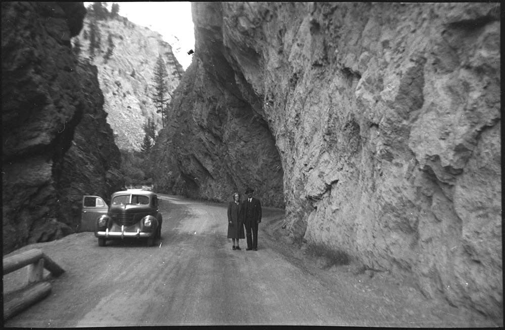
[Radium and berry picking]
https://archives.whyte.org/en/permalink/descriptions23830
- Part Of
- Luxton family fonds
- Scope & Content
- Item consists of negatives of couple standing in rock cut at Radium and Norman Luxon [?] holding a box of berries
- Date Range
- [1940-1960]
- Reference Code
- LUX / I / E4 / NA - 31 to NA - 32
- Description Level
- 6 / Item
- GMD
- Photograph
- Negative
2 images
- Part Of
- Luxton family fonds
- Description Level
- 6 / Item
- Fonds Number
- LUX
- Series
- LUX / I / E : Collected Material
- Sous-Fonds
- LUX / I : Norman Luxton sous-fonds
- Sub-Series
- LUX / I / E / 4 : Photographs
- Reference Code
- LUX / I / E4 / NA - 31 to NA - 32
- GMD
- Photograph
- Negative
- Date Range
- [1940-1960]
- Physical Description
- 2 photographs : b&w negatives ; 7 x 4.5 cm
- Scope & Content
- Item consists of negatives of couple standing in rock cut at Radium and Norman Luxon [?] holding a box of berries
- Subject Access
- Automobiles
- Family
- Roads
- Geographic Access
- Alberta
- British Columbia
- Radium
- Related Material
- Corresponding print for NA-31 is: LUX / I / E4 PA-157.
- Processing Status
- Processed
Images

This material is presented as originally created; it may contain outdated cultural descriptions and
potentially offensive content.
Read more.
Travel guides and maps
https://archives.whyte.org/en/permalink/descriptions56361
- Part Of
- Ben Gadd fonds
- Scope & Content
- Sub-series consists of travel brochures and maps which were collected and used by Ben Gadd. Sub-series contains five sub-sub series: M590 / I / A / i : Travel guides and pocket maps M590 / I / A / ii : Topographical maps M590 / I / A / iii : Geological maps M590 / I / A / iv : Highway maps M590 / …
- Date Range
- [ca.1920-2010]
- Reference Code
- M590 / I / A
- Description Level
- 4 / Sub-series
- GMD
- Map
- Textual record
- Part Of
- Ben Gadd fonds
- Description Level
- 4 / Sub-series
- Fonds Number
- M590
- V810
- S61
- Series
- M590 / I : Personal records
- Sous-Fonds
- M590
- Sub-Series
- M590 / I / A : Travel guides and maps
- Accession Number
- 2021.20
- Reference Code
- M590 / I / A
- GMD
- Map
- Textual record
- Date Range
- [ca.1920-2010]
- Physical Description
- ca. 274 maps -- ca. 61 travel guides, brochures
- Scope & Content
- Sub-series consists of travel brochures and maps which were collected and used by Ben Gadd. Sub-series contains five sub-sub series: M590 / I / A / i : Travel guides and pocket maps M590 / I / A / ii : Topographical maps M590 / I / A / iii : Geological maps M590 / I / A / iv : Highway maps M590 / I / A / v : Index maps, other
- Notes
- Some materials in sub-series are annotated with notes by Ben Gadd
- Name Access
- Gadd, Ben
- Subject Access
- Geography
- Geology
- Environment
- Map
- Tourism
- Tourist information
- Travel
- Trails
- Roads
- Transportation
- Natural history
- National parks and reserves
- Provincial parks and reserves
- Government
- Sports
- Recreation
- Hiking
- Geographic Access
- Canada
- Alberta
- British Columbia
- Banff National Park
- Jasper National Park
- Kootenay National Park
- Yoho National Park
- Waterton Lakes National Park
- Columbia Icefields
- United States of America
- Colorado
- Montana
- Yellowstone National Park
- Access Restrictions
- Restrictions may apply - some materials are fragile
- Reproduction Restrictions
- Restrictions may apply
- Language
- English
- Conservation
- Some fragile/torn materials stored in mylar
- Category
- Environment
- Exploration, discovery and travel
- Government
- Sports, recreation and leisure
- Transportation
- Tourism
- Title Source
- Title based on contents of sub-series
- Processing Status
- Processed
This material is presented as originally created; it may contain outdated cultural descriptions and
potentially offensive content.
Read more.