Narrow Results By
- Catharine Robb Whyte, O. C. (1906 – 1979, Canadian) 94
- Charles John Collings (1848 – 1931, British) 86
- James (Sr.) Simpson (1877 – 1972, Canadian) 71
- Robert William Sinclair (1939 – , Canadian) 68
- Peter Whyte (1905 – 1966, Canadian) 67
- Ernest C. W Lamarque (1879 – 1970, Canadian) 64
- John Hartman (1950 – , Canadian) 31
- Janet Holly Middleton (1922 – 2018, Canadian) 17
- Walter Joseph Phillips, R. C. A. (1884 – 1963, Canadian) 17
- Henry George Glyde (1906 – 1998, Canadian) 14
- Alfred Crocker Leighton, R. C. A. (1901 – 1965, Canadian) 13
- Unknown 11
- Photograph 29389
- Negative 17291
- Library - Book (including soft-cover and pamphlets) 14629
- Transparency 3187
- Library - Periodical 3157
- Library - Postcard 2944
- Textual record 2863
- Lantern slide 2559
- Map 2131
- Photograph print 2127
- Library - Maps and blueprints (unannotated; published)
- Graphite Drawing 1627
18 Flight Index Maps
https://archives.whyte.org/en/permalink/catalogue21509
- Subjects
- Aerial Photo Maps
- Notes
- Xerox copies
- Accession Number
- 2000
- Call Number
- C12-4
- Collection
- Archives Library
This material is presented as originally created; it may contain outdated cultural descriptions and
potentially offensive content.
Read more.
1978 map of Mount Assiniboine Provincial Park
https://archives.whyte.org/en/permalink/catalogue21315
- Medium
- Library - Maps and blueprints (unannotated; published)
- Map
- Published Date
- 1978 (transfered to manuscrpits Oct. 1994)
- Publisher
- Ministry of Recreation and Conservation
- Call Number
- C2-10.1 (e)
- Publisher
- Ministry of Recreation and Conservation
- Published Date
- 1978 (transfered to manuscrpits Oct. 1994)
- Subjects
- Mount Assiniboine Provincial Park
- Notes
- Descriptive Legend on back of map re: History Winter Activity, Access, Avalanche Safety, Equipment, Trail and Camping Information etc.
- Accession Number
- 11000
- Call Number
- C2-10.1 (e)
- Collection
- Archives Library
This material is presented as originally created; it may contain outdated cultural descriptions and
potentially offensive content.
Read more.
(a): Topographical sheets|(b): Original map
https://archives.whyte.org/en/permalink/catalogue24654
- Medium
- Library - Maps and blueprints (unannotated; published)
- Map
- Published Date
- 1889
- Publisher
- Dept. of the Interior
- Call Number
- C3-8.14 (a)
- C3-8.14 (b)
- Publisher
- Dept. of the Interior
- Published Date
- 1889
- Scale
- Scale:1:40,000
- Relief: Contour interval 100 ft.
- Subjects
- Anthracite
- Notes
- (b): 8 dup in map room
- Accession Number
- 675
- 400
- 3069
- Call Number
- C3-8.14 (a)
- C3-8.14 (b)
- Collection
- Archives Library
This material is presented as originally created; it may contain outdated cultural descriptions and
potentially offensive content.
Read more.
AAF aeronautical chart : North Saskatchewan River / compiled for the U.S. Army Air Forces by the U.S. Coast and Geodetic Survey
https://archives.whyte.org/en/permalink/catalogue24364
- Medium
- Library - Maps and blueprints (unannotated; published)
- Map
- Published Date
- 1943
- Publisher
- Washington, D.C.
- Call Number
- C6-12.1
- Publisher
- Washington, D.C.
- Published Date
- 1943
- Physical Description
- 1 map : col
- Scale
- 1 : 1,000,000
- Subjects
- Saskatchewan River, North
- Aviation
- Accession Number
- 4008
- Call Number
- C6-12.1
- Collection
- Archives Library
This material is presented as originally created; it may contain outdated cultural descriptions and
potentially offensive content.
Read more.
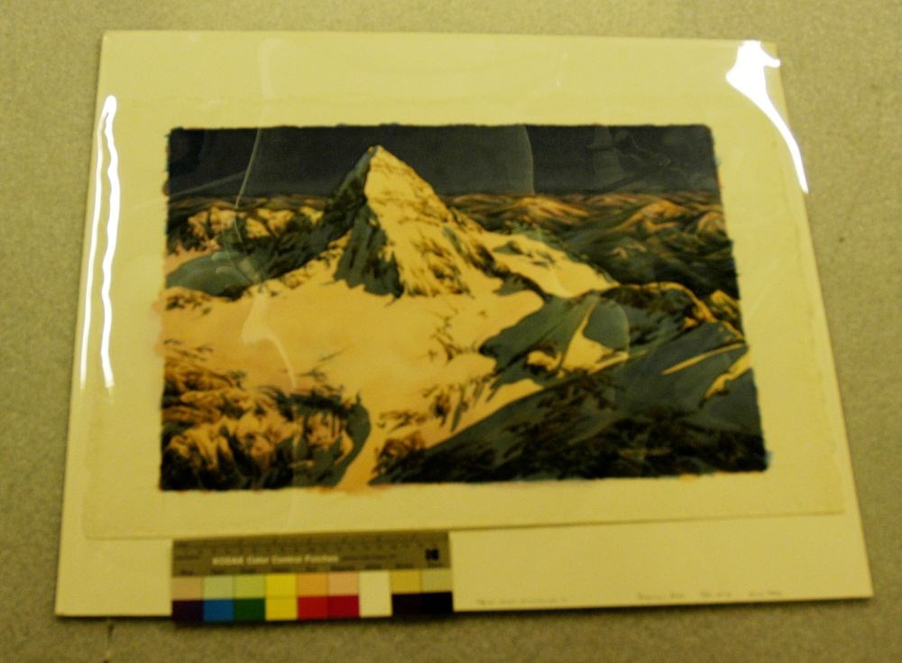
Above Mount Assiniboine #1
https://archives.whyte.org/en/permalink/artifactthr.05.01
- Artist
- Rene Thibault (1947 – )
- Date
- 2009
- Medium
- watercolour on paper
- Catalogue Number
- ThR.05.01
- Description
- Predominant colours are pink, blue, purple, green and brown. The painting is dominated by the pyramidal-shaped Mt. Assiniboine and the icefield below it. It appears to be an aerial view of sunrise on the mountain. The foreground is comprised of rocks showing through a snow-covered approach to the m…
1 image
- Artist
- Rene Thibault (1947 – )
- Title
- Above Mount Assiniboine #1
- Date
- 2009
- Medium
- watercolour on paper
- Dimensions
- 38.0 x 58.0 cm
- Description
- Predominant colours are pink, blue, purple, green and brown. The painting is dominated by the pyramidal-shaped Mt. Assiniboine and the icefield below it. It appears to be an aerial view of sunrise on the mountain. The foreground is comprised of rocks showing through a snow-covered approach to the mountain peak. The rocks are various shades of very dark blue, lighter blue and brown. To the viewer’s left the snow is tinged in various shades of pink as the morning light strikes it and the view to the right is still in the blue shades of shadow. The artist’s signature in white is in this area. The middle of the painting is the pink glow of the sun on snow with some shaded snow and rocks still showing to the viewer’s right. The top-half is a snow-covered Mt. Assiniboine with brown rock bands; viewer’s right in the sun’s light and viewer’s left in the shade. Beyond the mountain are hills and valleys of pink, blue and green. The sky is a very deep shade of purple and blue.
- Subject
- landscape
- mountains
- Mt. Assiniboine
- Credit
- Gift of Rene Thibault, 2009
- Catalogue Number
- ThR.05.01
Images
This material is presented as originally created; it may contain outdated cultural descriptions and
potentially offensive content.
Read more.
Abruzzi, Mount
https://archives.whyte.org/en/permalink/catalogue23436
- Medium
- Library - Maps and blueprints (unannotated; published)
- Map
- Published Date
- Updated from aerial photographs, taken in 1972. Culture check, 1975. Info current as of 1975.
- Publisher
- Surveys and Mapping Branch, Dept. of Energy, Mines and Resources
- Edition
- Edition 2
- Call Number
- NTS
- 82J/6
- Edition
- Edition 2
- Publisher
- Surveys and Mapping Branch, Dept. of Energy, Mines and Resources
- Published Date
- Updated from aerial photographs, taken in 1972. Culture check, 1975. Info current as of 1975.
- Scale
- Scale: 1:50,000
- Subjects
- Mount Abruzzi
- Notes
- National Topographic System
- Complete reference/reverse side of map
- Accession Number
- 9500
- Call Number
- NTS
- 82J/6
- Collection
- Archives Library
This material is presented as originally created; it may contain outdated cultural descriptions and
potentially offensive content.
Read more.
[Abruzzi, Mount 82J/6 East, B.C.]
https://archives.whyte.org/en/permalink/catalogue23438
- Medium
- Library - Maps and blueprints (unannotated; published)
- Map
- Published Date
- 1966
- Publisher
- Dept. of Mines and Technical Surveys
- Call Number
- NTS
- 82J/6E
- Publisher
- Dept. of Mines and Technical Surveys
- Published Date
- 1966
- Physical Description
- 1 map : col
- Scale
- Scale: 1:50,000
- Relief: Contour interval 100'
- Subjects
- Mount Abruzzi
- British Columbia
- Notes
- National Topographic System
- Accession Number
- 718
- Call Number
- NTS
- 82J/6E
- Collection
- Archives Library
This material is presented as originally created; it may contain outdated cultural descriptions and
potentially offensive content.
Read more.
[Abruzzi, Mount 82J/6 West, B.C.]
https://archives.whyte.org/en/permalink/catalogue23437
- Medium
- Library - Maps and blueprints (unannotated; published)
- Map
- Published Date
- 1966
- Publisher
- Dept. of Mines and Technical Surveys
- Call Number
- NTS
- 82J/6W
- Publisher
- Dept. of Mines and Technical Surveys
- Published Date
- 1966
- Physical Description
- 1 map : col
- Scale
- Scale: 1:50,000
- Relief: Contour interval 100'
- Subjects
- Mount Abruzzi
- British Columbia
- Notes
- National Topographic System
- Accession Number
- 718
- Call Number
- NTS
- 82J/6W
- Collection
- Archives Library
This material is presented as originally created; it may contain outdated cultural descriptions and
potentially offensive content.
Read more.
[Adams Lookout, Alberta]
https://archives.whyte.org/en/permalink/catalogue23439
- Medium
- Library - Maps and blueprints (unannotated; published)
- Map
- Published Date
- 1962
- Publisher
- Dept. of Mines & Technical Surveys
- Call Number
- NTS
- 83E/10E
- Publisher
- Dept. of Mines & Technical Surveys
- Published Date
- 1962
- Scale
- Scale: 1:50,000
- Subjects
- Adams Lookout
- Alberta
- Notes
- National Topographic System
- Accession Number
- 12000
- Call Number
- NTS
- 83E/10E
- Collection
- Archives Library
This material is presented as originally created; it may contain outdated cultural descriptions and
potentially offensive content.
Read more.
[Adams Lookout, Alberta]
https://archives.whyte.org/en/permalink/catalogue23440
- Medium
- Library - Maps and blueprints (unannotated; published)
- Map
- Published Date
- 1962
- Publisher
- Dept. of Mines and Technical Surveys
- Call Number
- NTS
- 83W/10W
- Publisher
- Dept. of Mines and Technical Surveys
- Published Date
- 1962
- Scale
- Scale: 1:50,000
- Subjects
- Adams Lookout
- Alberta
- Notes
- National Topographic System
- Accession Number
- 12000
- Call Number
- NTS
- 83W/10W
- Collection
- Archives Library
This material is presented as originally created; it may contain outdated cultural descriptions and
potentially offensive content.
Read more.
[Adams Plateau 82M/4 East, B.C.]
https://archives.whyte.org/en/permalink/catalogue23441
- Medium
- Library - Maps and blueprints (unannotated; published)
- Map
- Published Date
- 1961
- Publisher
- Department of Mines and Technical Surveys
- Call Number
- NTS
- 82M/4E
- Publisher
- Department of Mines and Technical Surveys
- Published Date
- 1961
- Physical Description
- 1 map : col
- Scale
- Scale: 1:50,000
- Relief: Contour interval 100 ft.
- Subjects
- Adams Plateau
- British Columbia
- Notes
- National Topographic System
- Accession Number
- 7000
- Call Number
- NTS
- 82M/4E
- Collection
- Archives Library
This material is presented as originally created; it may contain outdated cultural descriptions and
potentially offensive content.
Read more.
[Adams Plateau 82M/4 West, B.C.]
https://archives.whyte.org/en/permalink/catalogue23442
- Medium
- Library - Maps and blueprints (unannotated; published)
- Map
- Published Date
- 1961
- Publisher
- Department of Mines and Technical Surveys
- Call Number
- NTS
- 82M/4W
- Publisher
- Department of Mines and Technical Surveys
- Published Date
- 1961
- Physical Description
- 1 map : col
- Scale
- Scale: 1:50,000
- Relief: Contour interval 100 ft.
- Subjects
- Adams Plateau
- British Columbia
- Notes
- National Topographic System
- Accession Number
- 7000
- Call Number
- NTS
- 82M/4W
- Collection
- Archives Library
This material is presented as originally created; it may contain outdated cultural descriptions and
potentially offensive content.
Read more.
[Adams River 82M/11 East, B.C.]
https://archives.whyte.org/en/permalink/catalogue23443
- Medium
- Library - Maps and blueprints (unannotated; published)
- Map
- Published Date
- 1961
- Publisher
- Dept. of Mines and Technical Surveys
- Call Number
- NTS
- 82M/11E
- Publisher
- Dept. of Mines and Technical Surveys
- Published Date
- 1961
- Physical Description
- 1 map : col
- Scale
- Scale: 1:50,000
- Relief: Contour interval 100 ft.
- Subjects
- Adams River
- British Columbia
- Notes
- National Topographic System
- Accession Number
- 3000
- Call Number
- NTS
- 82M/11E
- Collection
- Archives Library
This material is presented as originally created; it may contain outdated cultural descriptions and
potentially offensive content.
Read more.
[Adams River 82M/11 West, B.C.]
https://archives.whyte.org/en/permalink/catalogue23444
- Medium
- Library - Maps and blueprints (unannotated; published)
- Map
- Published Date
- 1961
- Publisher
- Dept. of Mines and Technical Surveys
- Call Number
- NTS
- 82M/11W
- Publisher
- Dept. of Mines and Technical Surveys
- Published Date
- 1961
- Physical Description
- 1 map : col
- Scale
- Scale: 1:50,000
- Relief: Contour interval 100 ft.
- Subjects
- Adams River
- British Columbia
- Notes
- National Topographic System
- Accession Number
- 3000
- Call Number
- NTS
- 82M/11W
- Collection
- Archives Library
This material is presented as originally created; it may contain outdated cultural descriptions and
potentially offensive content.
Read more.
Aerochrome Infrared photograph of Banff and surrounding area
https://archives.whyte.org/en/permalink/catalogue24805
- Medium
- Library - Maps and blueprints (unannotated; published)
- Map
- Published Date
- August 1972
- Call Number
- C12-4.22
- Published Date
- August 1972
- Scale
- 1:17,000
- Subjects
- Banff - Aerial Photo
- Notes
- Legend: 12 designated townsite areas
- See: Fig. 1, 2, 3 on reverse side of map
- Call Number
- C12-4.22
- Collection
- Archives Library
This material is presented as originally created; it may contain outdated cultural descriptions and
potentially offensive content.
Read more.
- Medium
- Library - Maps and blueprints (unannotated; published)
- Map
- Published Date
- 1922
- Publisher
- National Geographic Society
- Call Number
- C13-7.1
- Publisher
- National Geographic Society
- Published Date
- 1922
- Scale
- 1" = 185 miles
- Subjects
- Africa
- Notes
- there is a duplicate
- Accession Number
- 400
- 576
- Call Number
- C13-7.1
- Collection
- Archives Library
This material is presented as originally created; it may contain outdated cultural descriptions and
potentially offensive content.
Read more.
[Africa, Northwestern]
https://archives.whyte.org/en/permalink/catalogue24841
- Medium
- Library - Maps and blueprints (unannotated; published)
- Map
- Published Date
- 1966
- Publisher
- National Geographic Society
- Call Number
- C13-7.3
- Publisher
- National Geographic Society
- Published Date
- 1966
- Scale
- Scale: 125 miles to 1 inch
- Relief: Bench marks
- Subjects
- Northwestern Africa
- Call Number
- C13-7.3
- Collection
- Archives Library
This material is presented as originally created; it may contain outdated cultural descriptions and
potentially offensive content.
Read more.
[Africa, Southern]
https://archives.whyte.org/en/permalink/catalogue24840
- Medium
- Library - Maps and blueprints (unannotated; published)
- Map
- Published Date
- 1962
- Publisher
- National Geographic Society
- Call Number
- C13-7.2
- Publisher
- National Geographic Society
- Published Date
- 1962
- Scale
- Scale: 125 miles to 1 inch
- Relief: bench marks
- Subjects
- Southern Africa
- Accession Number
- 495
- Call Number
- C13-7.2
- Collection
- Archives Library
This material is presented as originally created; it may contain outdated cultural descriptions and
potentially offensive content.
Read more.
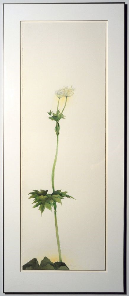
- Date
- 2000
- Medium
- watercolour on arches paper
- Catalogue Number
- SiR.05.45
- Description
- A thin green plant rises from the bottom centre, from a dark mass. The stem has several leaves part way up and at the top, with two white flowers.
1 image
- Title
- Aftermath
- Date
- 2000
- Medium
- watercolour on arches paper
- Dimensions
- 151 x 50.5 cm
- Description
- A thin green plant rises from the bottom centre, from a dark mass. The stem has several leaves part way up and at the top, with two white flowers.
- Credit
- Gift of Robert William Sinclair, Edmonton, 2010
- Catalogue Number
- SiR.05.45
Images
This material is presented as originally created; it may contain outdated cultural descriptions and
potentially offensive content.
Read more.
Airplane Lake, British Columbia
https://archives.whyte.org/en/permalink/artifactlae.05.02
- Date
- 1936
- Medium
- watercolour on paper
- Catalogue Number
- LaE.05.02
- Description
- General colour: light green, brown. The lake sits in the lower third of the picture between two points of grassy treed land. One comes from the left side across the bottom, the other from the right side, part way up to right of center. A brown mountain range rises up from the lake and to the right …
1 image
- Title
- Airplane Lake, British Columbia
- Date
- 1936
- Medium
- watercolour on paper
- Dimensions
- 26.9 x 43.5 cm
- Description
- General colour: light green, brown. The lake sits in the lower third of the picture between two points of grassy treed land. One comes from the left side across the bottom, the other from the right side, part way up to right of center. A brown mountain range rises up from the lake and to the right side. Sky beyond with two birds flying center and left.
- Subject
- landscape
- mountain
- lake
- Ernest Lamarque
- Credit
- Gift of Ernest Lamarque (Estate), 1971
- Catalogue Number
- LaE.05.02
Images

This material is presented as originally created; it may contain outdated cultural descriptions and
potentially offensive content.
Read more.