Narrow Results By
Columbia Valley
https://archives.whyte.org/en/permalink/catalogue24627
- Physical Description
- Black and white
- Scale
- Relief: Spot heights
- Subjects
- Selkirk Mountains
- Accession Number
- 400
- Call Number
- C3-4.6
- Collection
- Archives Library
This material is presented as originally created; it may contain outdated cultural descriptions and
potentially offensive content.
Read more.
Drainage Patterns
https://archives.whyte.org/en/permalink/catalogue21492
- Medium
- Library - Maps and blueprints (unannotated; published)
- Map
- Published Date
- 1900
- Call Number
- C12-1.17
- Published Date
- 1900
- Subjects
- Rocky Mountains
- Notes
- 2 sections
- Photostatic copy from Public Archives
- Accession Number
- 675
- Call Number
- C12-1.17
- Collection
- Archives Library
This material is presented as originally created; it may contain outdated cultural descriptions and
potentially offensive content.
Read more.
Low Clouds, Rocky Mountains
https://archives.whyte.org/en/permalink/artifactgar.05.01
- Date
- n.d.
- Medium
- watercolour on paper
- Catalogue Number
- GaR.05.01
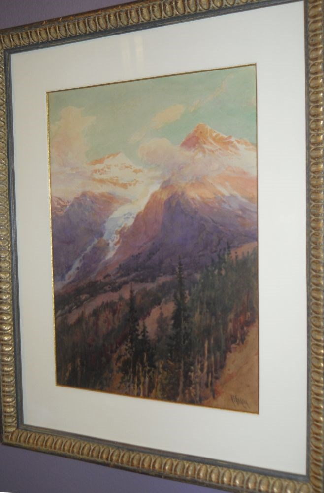
- Description
- Vertical watercolour where vantage point is at mid-slope of a mountainside, looking to two peaks in the upper portion of the watercolour. In immediate foreground are coniferous trees painted in dark green and tan. The two peaks are shades of purple, coral and pink. A glacier or snow covered area…
1 image
- Title
- Low Clouds, Rocky Mountains
- Date
- n.d.
- Medium
- watercolour on paper
- Dimensions
- 34.2 x 24.4 cm
- Description
- Vertical watercolour where vantage point is at mid-slope of a mountainside, looking to two peaks in the upper portion of the watercolour. In immediate foreground are coniferous trees painted in dark green and tan. The two peaks are shades of purple, coral and pink. A glacier or snow covered area extends down from between the two peaks. Snow is prominent on the left peak. Low clouds obscure the peaks. The sky is blue.
- Subject
- landscape
- Rocky Mountains
- Credit
- Purchased from The Collector’s Gallery, Calgary, 2004
- Catalogue Number
- GaR.05.01
Images
This material is presented as originally created; it may contain outdated cultural descriptions and
potentially offensive content.
Read more.
The main range adjacent to the Canadian Pacific Railway
https://archives.whyte.org/en/permalink/catalogue24638
- Medium
- Library - Maps and blueprints (unannotated; published)
- Map
- Published Date
- 1907
- Publisher
- Dept. of the Interior
- Call Number
- C3-7.2
- Publisher
- Dept. of the Interior
- Published Date
- 1907
- Physical Description
- Black and white
- Scale
- Scale: 1:80,000
- Relief: Contour interval 250'
- Subjects
- Rocky Mountains
- Accession Number
- 400
- Call Number
- C3-7.2
- Collection
- Archives Library
This material is presented as originally created; it may contain outdated cultural descriptions and
potentially offensive content.
Read more.
Map Of A portion Of The Watershed Of Rocky Mountains From Survey by S.E.S. Allen
https://archives.whyte.org/en/permalink/catalogue24797
- Medium
- Library - Maps and blueprints (unannotated; published)
- Map
- Published Date
- n.d.
- Publisher
- J.L. Smith, Philadelphia
- Call Number
- C12-1.29
- Publisher
- J.L. Smith, Philadelphia
- Published Date
- n.d.
- Scale
- 1 mile to the inch
- Subjects
- Rocky Mountains
- Notes
- Photostatic copy from A.C.C.
- Accession Number
- 2487
- Copy 2
- Call Number
- C12-1.29
- Collection
- Archives Library
This material is presented as originally created; it may contain outdated cultural descriptions and
potentially offensive content.
Read more.
- Date
- 1984
- Medium
- watercolour on paper
- Catalogue Number
- KnD.05.03
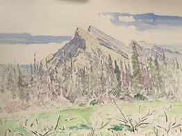
- Description
- A watercolour landscape painting of Mount Rundle with blue and white sky in the top half, and evergreen trees in the middle. The bottom third is loosely drawn shrubbery and green grassy area
1 image
- Title
- Mt. Rundle
- Date
- 1984
- Medium
- watercolour on paper
- Dimensions
- 55.9 x 76.2 cm
- Description
- A watercolour landscape painting of Mount Rundle with blue and white sky in the top half, and evergreen trees in the middle. The bottom third is loosely drawn shrubbery and green grassy area
- Credit
- Gift of Dorothy Elsie Knowles Perehudoff, Saskatoon, 2016
- Catalogue Number
- KnD.05.03
Images
This material is presented as originally created; it may contain outdated cultural descriptions and
potentially offensive content.
Read more.
Parks of the Canadian Rockies
https://archives.whyte.org/en/permalink/catalogue21449
- Medium
- Library - Maps and blueprints (unannotated; published)
- Map
- Published Date
- 1970
- Publisher
- Mitchell Map Services, Vancouver
- Call Number
- C3-6.4
- Publisher
- Mitchell Map Services, Vancouver
- Published Date
- 1970
- Subjects
- Rocky Mountains
- Notes
- Copy 2
- Accession Number
- 1000
- Call Number
- C3-6.4
- Collection
- Archives Library
This material is presented as originally created; it may contain outdated cultural descriptions and
potentially offensive content.
Read more.
Preliminary map of the Canadian Rocky Mtns between Jarvis Pass and Yellowhead Pass showing the route followed by Mary Jobe in August 1914|Mary Jobe's trip through the northern Rockies
https://archives.whyte.org/en/permalink/catalogue23371
- Medium
- Library - Maps and blueprints (unannotated; published)
- Map
- Published Date
- 1915
- Publisher
- Bulletin of the American Geographic Society, vol. XLV11, 7
- Call Number
- C6-3.9(a)
- C6-3.9(b)
- Publisher
- Bulletin of the American Geographic Society, vol. XLV11, 7
- Published Date
- 1915
- Scale
- 1:300,000
- Subjects
- Rocky Mountains
- Canadian
- Notes
- xerox copy of M.67, M2.1
- Accession Number
- 6500
- Call Number
- C6-3.9(a)
- C6-3.9(b)
- Collection
- Archives Library
This material is presented as originally created; it may contain outdated cultural descriptions and
potentially offensive content.
Read more.
Preliminary map of the Canadian Rocky Mtns between Jarvis Pass and Yellowhead Pass showing the route followed by Mary Jobe in August 1914|Mary Jobe's trip through the northern Rockies
https://archives.whyte.org/en/permalink/catalogue24304
- Medium
- Library - Maps and blueprints (unannotated; published)
- Map
- Published Date
- 1915
- Publisher
- Bulletin of the American Geographic Society, vol. XLV11, 7
- Call Number
- C6-3.9(a)
- C6-3.9(b)
- Publisher
- Bulletin of the American Geographic Society, vol. XLV11, 7
- Published Date
- 1915
- Scale
- 1:300,000
- Subjects
- Rocky Mountains
- Canadian
- Notes
- xerox copy of M.67, M2.1
- Accession Number
- 6500
- Call Number
- C6-3.9(a)
- C6-3.9(b)
- Collection
- Archives Library
This material is presented as originally created; it may contain outdated cultural descriptions and
potentially offensive content.
Read more.
Reconnaissace map of the Northern Selkiek Mountains and the Big Bend of the Columbia River
https://archives.whyte.org/en/permalink/catalogue24625
- Medium
- Library - Maps and blueprints (unannotated; published)
- Map
- Published Date
- 1915
- Publisher
- Surveyor General's Office
- Call Number
- C3-4.4
- Publisher
- Surveyor General's Office
- Published Date
- 1915
- Physical Description
- Colour
- Scale
- 1:250,000
- Subjects
- Selkirk Mountains
- Accession Number
- 1105
- 5956
- Call Number
- C3-4.4
- Collection
- Archives Library
This material is presented as originally created; it may contain outdated cultural descriptions and
potentially offensive content.
Read more.